Worthing, East

Settlement in Sussex Worthing

England

Worthing, East

Worthing : winter sunshine by the beach
Worthing : winter sunshine by the beach Credit: Jim Osley

Worthing is a town located on the southeastern coast of England, within the county of East Sussex. Situated on the English Channel, Worthing is known for its scenic beauty and rich history. The town covers an area of approximately 32 square kilometers and has a population of around 110,000 people.

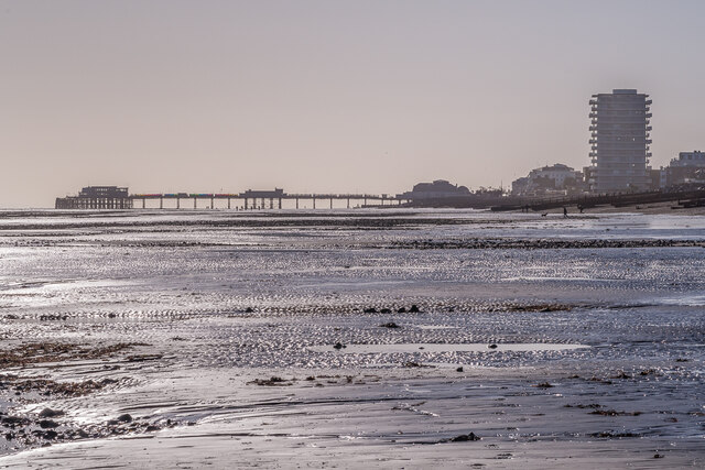
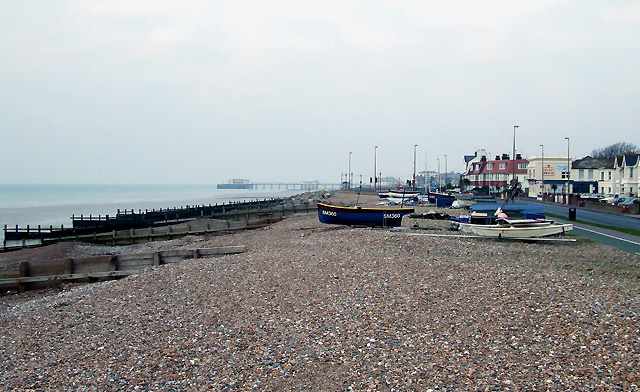
With its origins dating back to the Stone Age, Worthing has evolved over the centuries into a popular seaside resort. Its long pebble beach stretches for around five miles, attracting tourists and locals alike. The Victorian pier, built in 1862, is a prominent landmark and offers stunning views of the coastline.

Worthing boasts a temperate climate, with mild winters and cool summers. The town experiences relatively high levels of rainfall throughout the year. The area's geography is characterized by a combination of urban development and green spaces. Worthing has several parks and gardens, such as Beach House Park and Highdown Gardens, which provide serene environments for relaxation and recreation.

Culturally, Worthing offers a diverse range of activities and events. The town is home to various art galleries, museums, and theaters, including the Pavilion Theatre and the Worthing Museum and Art Gallery. The annual Worthing International Birdman competition attracts participants from around the world, who attempt to fly the furthest distance from the town's pier.

Transportation in Worthing is well-developed, with easy access to nearby cities like Brighton and Chichester. The town has a comprehensive bus network, and Worthing railway station connects to London and other major cities.

In summary, Worthing is a picturesque seaside town in East Sussex, renowned for its beautiful beach, cultural attractions, and convenient location.

If you have any feedback on the listing, please let us know in the comments section below.

Worthing, East Images

Images are sourced within 2km of 50.817025/-0.351011 or Grid Reference TQ1603. Thanks to Geograph Open Source API. All images are credited.

Worthing : winter sunshine by the beach
Worthing Lido Grade II listed building from 1925. Built to a design by architects Adshead and Ramsey. Description at this <span class="nowrap"><a title="https://historicengland.org.uk/listing/the-list/list-entry/1250795?section=official-listing" rel="nofollow ugc noopener" href="https://historicengland.org.uk/listing/the-list/list-entry/1250795?section=official-listing">Link</a><img style="margin-left:2px;" alt="External link" title="External link - shift click to open in new window" src="https://s1.geograph.org.uk/img/external.png" width="10" height="10"/></span>.
Worthing Lido
Grade II listed building from 1925. Built to a design by architects Adshead and Ramsey. Description at this LinkExternal link.
Worthing Pier Grade II listed : history and description at this <span class="nowrap"><a title="https://historicengland.org.uk/listing/the-list/list-entry/1263242" rel="nofollow ugc noopener" href="https://historicengland.org.uk/listing/the-list/list-entry/1263242">Link</a><img style="margin-left:2px;" alt="External link" title="External link - shift click to open in new window" src="https://s1.geograph.org.uk/img/external.png" width="10" height="10"/></span>.
Worthing Pier
Grade II listed : history and description at this LinkExternal link.
Worthing Pavilion Theatre Grade II listed building at the foot of Worthing Pier from 1926 (architects: Adshead & Ramsey). History at this <span class="nowrap"><a title="https://wtm.uk/visit/wtmstory/history-of-the-pavilion/" rel="nofollow ugc noopener" href="https://wtm.uk/visit/wtmstory/history-of-the-pavilion/">Link</a><img style="margin-left:2px;" alt="External link" title="External link - shift click to open in new window" src="https://s1.geograph.org.uk/img/external.png" width="10" height="10"/></span>.
Worthing Pavilion Theatre
Grade II listed building at the foot of Worthing Pier from 1926 (architects: Adshead & Ramsey). History at this LinkExternal link.
Worthing : veteran mods with scooters More on the mod sub-culture at this <span class="nowrap"><a title="https://en.wikipedia.org/wiki/Mod_(subculture)" rel="nofollow ugc noopener" href="https://en.wikipedia.org/wiki/Mod_(subculture)">Link</a><img style="margin-left:2px;" alt="External link" title="External link - shift click to open in new window" src="https://s1.geograph.org.uk/img/external.png" width="10" height="10"/></span>.
Worthing : veteran mods with scooters
More on the mod sub-culture at this LinkExternal link.
Worthing : mod scooters More on the mod sub-culture at this <span class="nowrap"><a title="https://en.wikipedia.org/wiki/Mod_(subculture)" rel="nofollow ugc noopener" href="https://en.wikipedia.org/wiki/Mod_(subculture)">Link</a><img style="margin-left:2px;" alt="External link" title="External link - shift click to open in new window" src="https://s1.geograph.org.uk/img/external.png" width="10" height="10"/></span>.
Worthing : mod scooters
More on the mod sub-culture at this LinkExternal link.
Worthing : mural, West Buildings
Worthing : Salvation Army citadel Built in 1912 to a design by Oswald Archer, architect to the Salvation Army.
(Worthing Gazette - Wednesday 03 April 1912, p. 3)
Worthing : Salvation Army citadel
Built in 1912 to a design by Oswald Archer, architect to the Salvation Army. (Worthing Gazette - Wednesday 03 April 1912, p. 3)
Worthing : Connaught Cinema Built as The Picturedrome in 1913-1914, the "Moderne" styling to the frontage dates from 1933. More at this <span class="nowrap"><a title="http://cinematreasures.org/theaters/23914" rel="nofollow ugc noopener" href="http://cinematreasures.org/theaters/23914">Link</a><img style="margin-left:2px;" alt="External link" title="External link - shift click to open in new window" src="https://s1.geograph.org.uk/img/external.png" width="10" height="10"/></span>.
Worthing : Connaught Cinema
Built as The Picturedrome in 1913-1914, the "Moderne" styling to the frontage dates from 1933. More at this LinkExternal link.
Worthing : Royal Arcade
Worthing : housing terrace, New Parade
Worthing : fishing boats and sales point
Worthing : fishing vessels
Worthing : Beach House Grade II* listed building built to a design by architect John Rebecca. Description at this <span class="nowrap"><a title="https://historicengland.org.uk/listing/the-list/list-entry/1025808" rel="nofollow ugc noopener" href="https://historicengland.org.uk/listing/the-list/list-entry/1025808">Link</a><img style="margin-left:2px;" alt="External link" title="External link - shift click to open in new window" src="https://s1.geograph.org.uk/img/external.png" width="10" height="10"/></span>.
Worthing : Beach House
Grade II* listed building built to a design by architect John Rebecca. Description at this LinkExternal link.
Worthing : Dome Cinema Grade II* listed building. Description at this <span class="nowrap"><a title="https://historicengland.org.uk/listing/the-list/list-entry/1250850?section=official-list-entry" rel="nofollow ugc noopener" href="https://historicengland.org.uk/listing/the-list/list-entry/1250850?section=official-list-entry">Link</a><img style="margin-left:2px;" alt="External link" title="External link - shift click to open in new window" src="https://s1.geograph.org.uk/img/external.png" width="10" height="10"/></span>. For the full story of the Dome see this <span class="nowrap"><a title="https://www.worthingdomecinema.com/" rel="nofollow ugc noopener" href="https://www.worthingdomecinema.com/">Link</a><img style="margin-left:2px;" alt="External link" title="External link - shift click to open in new window" src="https://s1.geograph.org.uk/img/external.png" width="10" height="10"/></span>.
Worthing : Dome Cinema
Grade II* listed building. Description at this LinkExternal link. For the full story of the Dome see this LinkExternal link.
East Worthing Beach Looking along East Worthing Beach at low tide, with Worthing Pier in the background and the apartment block Bayside Vista on the right.
East Worthing Beach
Looking along East Worthing Beach at low tide, with Worthing Pier in the background and the apartment block Bayside Vista on the right.
Worthing Pier A telephoto view of Worthing Pier seen at low tide from East Worthing Beach.
Worthing Pier
A telephoto view of Worthing Pier seen at low tide from East Worthing Beach.
Worthing Pier - Grade II listed Bicycle parking at entrance to the pier and theatre.
Worthing Pier - Grade II listed
Bicycle parking at entrance to the pier and theatre.
Show me another place!

Worthing, East is located at Grid Ref: TQ1603 (Lat: 50.817025, Lng: -0.351011)

Administrative County: West Sussex

District: Worthing

Police Authority: Sussex

What 3 Words

///paper.riots.rinse. Near Worthing, West Sussex

Related Wikis

East Worthing

East Worthing is a residential area of Worthing in the Worthing district, in the county of West Sussex, England, situated immediately to the east of Worthing...

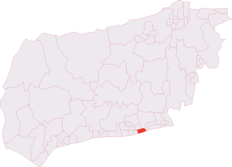
Worthing East (electoral division)

Worthing East is an electoral division of West Sussex in the United Kingdom, and returns one member to sit on West Sussex County Council. == Extent... ==
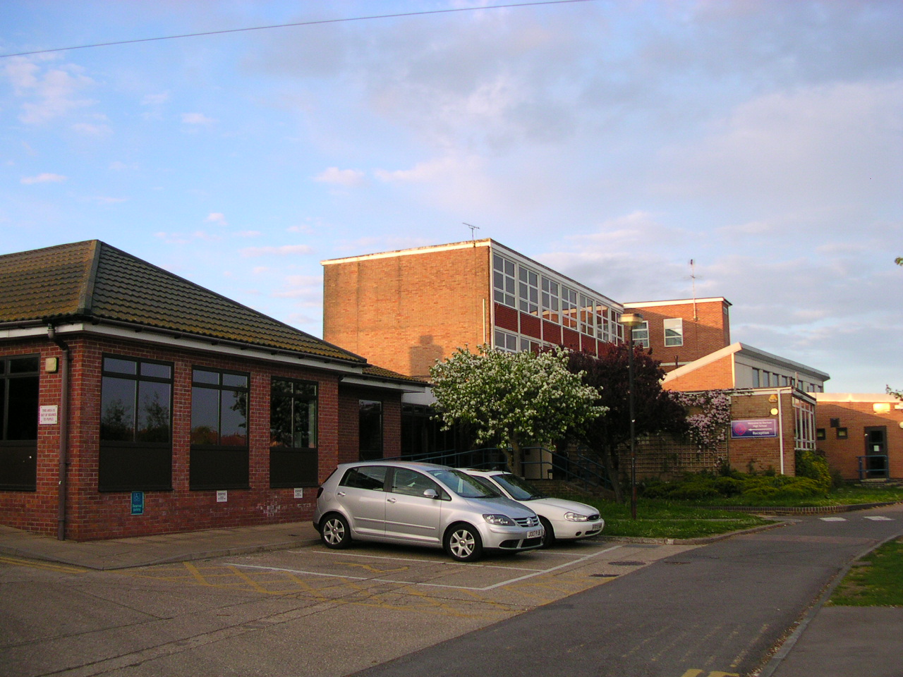
Davison High School

Davison High School is a girls' Church of England secondary school serving pupils aged 11 to 16 in Worthing, West Sussex, England. In its last inspection...

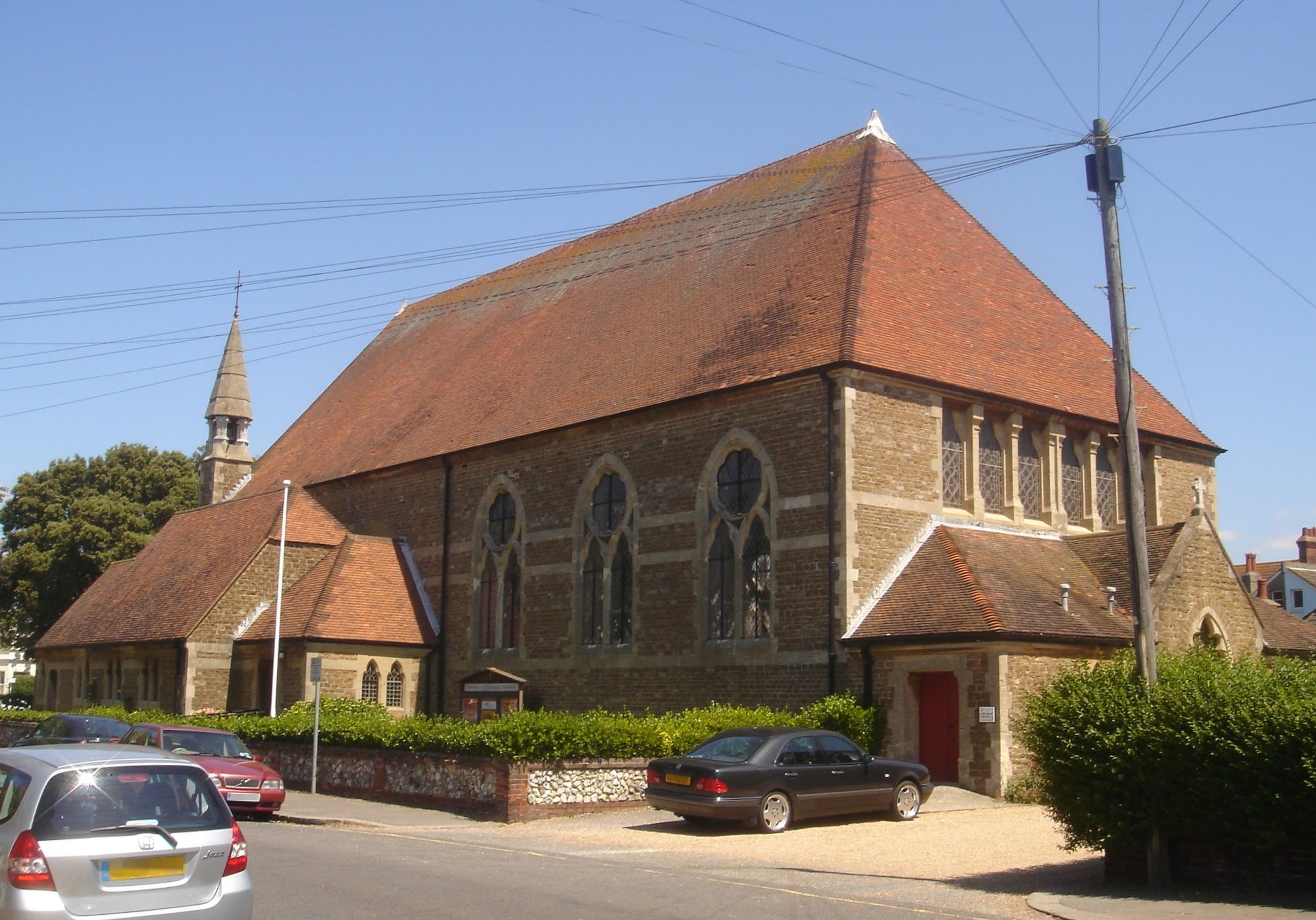
St George's Church, Worthing

St George's Church is an Anglican church in the East Worthing area of the borough of Worthing, one of seven local government districts in the English county...

Nearby Amenities

Located within 500m of 50.817025,-0.351011
Created By: almien_coastlines
Source: PGS
Lat/Long: 50.812679/-0.35027
Created By: almien_coastlines
Source: PGS
Lat/Long: 50.812917/-0.349447
Created By: almien_coastlines
Source: PGS
Lat/Long: 50.813145/-0.34822
Created By: almien_coastlines
Source: PGS
Lat/Long: 50.813383/-0.347398
Traffic Signals
Traffic Signals: pedestrian_crossing
Traffic Signals Direction: forward
Lat/Long: 50.8131391/-0.35176
Bicycle Parking
Bicycle Parking: stands
Capacity: 4
Check Date: 2022-07-20
Covered: no
Lat/Long: 50.8139467/-0.3477529
Traffic Signals
Traffic Signals: pedestrian_crossing
Traffic Signals Direction: both
Lat/Long: 50.8140083/-0.3479898
Bench
Backrest: yes
Lat/Long: 50.8139642/-0.3476147
Bus Stop
Gannon Road
Bus: yes
Naptan AtcoCode: 4400WO0400
Naptan Bearing: W
Naptan CommonName: Gannon Road
Naptan Indicator: adj
Naptan Landmark: Gannon Road
Naptan NaptanCode: wsxdpmag
Naptan ShortCommonName: Gannon Road
Naptan Street: Lyndhurst Road
Naptan Verified: no
Public Transport: platform
Source: naptan_import
Lat/Long: 50.8164753/-0.3566568
Bus Stop
Gannon Road
Naptan AtcoCode: 4400WO0401
Naptan Bearing: E
Naptan CommonName: Gannon Road
Naptan Indicator: opp
Naptan Landmark: Windsor Road
Naptan NaptanCode: wsxdpmaj
Naptan ShortCommonName: Gannon Road
Naptan Street: Lyndhurst Road
Naptan Verified: no
Source: naptan_import
Lat/Long: 50.8166842/-0.3561668
Bus Stop
Coronation Buildings
Naptan AtcoCode: 4400WO0402
Naptan Bearing: E
Naptan CommonName: Coronation Buildings
Naptan Indicator: opp
Naptan Landmark: Chatham Road
Naptan NaptanCode: wsxdpmam
Naptan ShortCommonName: Coronation Buildings
Naptan Street: Brougham Road
Naptan Verified: no
Source: naptan_import
Lat/Long: 50.8171215/-0.3514666
Bus Stop
Coronation Buildings
Naptan AtcoCode: 4400WO0403
Naptan Bearing: W
Naptan CommonName: Coronation Buildings
Naptan Indicator: adj
Naptan Landmark: Chatham Road
Naptan NaptanCode: wsxdpmap
Naptan ShortCommonName: Coronation Buildings
Naptan Street: Brougham Road
Naptan Verified: no
Source: naptan_import
Lat/Long: 50.8169943/-0.3513717
Bus Stop
Ford Garage
Naptan AtcoCode: 4400WO0404
Naptan Bearing: W
Naptan CommonName: Ford Garage
Naptan Indicator: o/s Training Centre
Naptan Landmark: Dinnages Ford Garage
Naptan NaptanCode: wsxdpmat
Naptan Street: Brougham Road
Naptan Verified: no
Source: naptan_import
Lat/Long: 50.8170579/-0.3495097
Bus Stop
Ford Garage
Bus: yes
Naptan AtcoCode: 4400WO0405
Naptan Bearing: E
Naptan CommonName: Ford Garage
Naptan Indicator: o/s Garage
Naptan Landmark: Dinnages Ford Garage
Naptan NaptanCode: wsxdpmaw
Naptan Street: Brougham Road
Naptan Verified: no
Public Transport: platform
Source: naptan_import
Lat/Long: 50.8171725/-0.3487107
Bus Stop
Brookdean Road
Naptan AtcoCode: 4400WO0406
Naptan Bearing: W
Naptan CommonName: Brookdean Road
Naptan Indicator: o/s Coronation Homelets
Naptan Landmark: Brookdean Road
Naptan NaptanCode: wsxdpmda
Naptan Street: Brougham Road
Naptan Verified: no
Source: naptan_import
Lat/Long: 50.8168852/-0.346208
Bus Stop
Brookdean Road
Naptan AtcoCode: 4400WO0407
Naptan Bearing: E
Naptan CommonName: Brookdean Road
Naptan Indicator: adj Brookdean Rd
Naptan Landmark: Brookdean Road
Naptan NaptanCode: wsxdpmdg
Naptan Street: Brougham Road
Naptan Verified: no
Source: naptan_import
Lat/Long: 50.8169618/-0.3452683
Bus Stop
Chester Avenue
Naptan AtcoCode: 4400WO0408
Naptan Bearing: N
Naptan CommonName: Chester Avenue
Naptan Indicator: adj
Naptan Landmark: Lyndhurst Road
Naptan NaptanCode: wsxdpmdj
Naptan ShortCommonName: Chester Avenue
Naptan Street: Ham Road
Naptan Verified: no
Source: naptan_import
Lat/Long: 50.8174294/-0.3522508
Bus Stop
Chester Avenue
Bus: yes
Naptan AtcoCode: 4400WO0409
Naptan Bearing: S
Naptan CommonName: Chester Avenue
Naptan Indicator: opp
Naptan Landmark: Brougham Road
Naptan NaptanCode: wsxdpmdm
Naptan ShortCommonName: Chester Avenue
Naptan Street: Ham Road
Naptan Verified: no
Public Transport: platform
Source: naptan_import
Lat/Long: 50.8173812/-0.3520253
Bus Stop
Mansfield Road
Bus: yes
Naptan AtcoCode: 4400WO0410
Naptan Bearing: S
Naptan CommonName: Mansfield Road
Naptan Indicator: adj
Naptan Landmark: Meadow Road
Naptan NaptanCode: wsxdpmdp
Naptan ShortCommonName: Mansfield Road
Naptan Street: Ham Road
Naptan Verified: no
Public Transport: platform
Source: naptan_import
Lat/Long: 50.8183475/-0.3523036
Bus Stop
Mansfield Road
Naptan AtcoCode: 4400WO0411
Naptan Bearing: N
Naptan CommonName: Mansfield Road
Naptan Indicator: opp
Naptan Landmark: Mansfield Road
Naptan NaptanCode: wsxdpmdt
Naptan ShortCommonName: Mansfield Road
Naptan Street: Ham Road
Naptan Verified: no
Source: naptan_import
Lat/Long: 50.8184955/-0.3525966
Bus Stop
East Worthing Station
Bench: no
Bin: no
Lit: yes
Naptan AtcoCode: 4400WO0412
Naptan Bearing: S
Naptan CommonName: East Worthing Station
Naptan Indicator: opp Chesswood Road
Naptan Landmark: Chesswood Road
Naptan NaptanCode: wsxdpmdw
Naptan Street: Ham Road
Naptan Verified: no
Shelter: no
Source: naptan_import
Tactile Paving: no
Lat/Long: 50.8205215/-0.3540444
Bus Stop
East Worthing Station
Bench: no
Bin: yes
Bus: yes
Lit: yes
Naptan AtcoCode: 4400WO0413
Naptan Bearing: N
Naptan CommonName: East Worthing Station
Naptan Indicator: adj Chesswood Road
Naptan Landmark: Chesswood Road
Naptan NaptanCode: wsxdpmga
Naptan Street: Ham Road
Naptan Verified: no
Public Transport: platform
Shelter: no
Source: naptan_import
Tactile Paving: no
Lat/Long: 50.8208599/-0.3544442
Bus Stop
Windsor Road
Bench: no
Bin: no
Naptan AtcoCode: 4400WO0454
Naptan Bearing: E
Naptan CommonName: Windsor Road
Naptan Indicator: Opp The Esplanade
Naptan Landmark: Windsor Road
Naptan NaptanCode: wsxdptat
Naptan Street: Brighton Road
Public Transport: platform
Shelter: no
Source: naptan_import
Lat/Long: 50.8130072/-0.3539368
Bus Stop
The Half Brick
Bench: yes
Bin: yes
Bus: yes
Lit: yes
Naptan AtcoCode: 4400WO0455
Naptan Bearing: W
Naptan CommonName: The Half Brick
Naptan Indicator: Opp The Half Brick
Naptan Landmark: B2223
Naptan NaptanCode: wsxdptaw
Naptan Street: Brighton Road
Naptan Verified: no
Public Transport: platform
Shelter: yes
Source: naptan_import
Tactile Paving: no
Lat/Long: 50.8129905/-0.3519065
Bus Stop
The Half Brick
Bench: no
Bus: yes
Naptan AtcoCode: 4400WO0456
Naptan Bearing: E
Naptan CommonName: The Half Brick
Naptan Indicator: o/s Windsor Court
Naptan Landmark: B2223
Naptan NaptanCode: wsxdptda
Naptan Street: Brighton Road
Naptan Verified: no
Public Transport: platform
Shelter: no
Source: naptan_import
Lat/Long: 50.8135844/-0.35064
Bus Stop
Heatherstone Road
Bench: no
Bin: no
Lit: yes
Naptan AtcoCode: 4400WO0457
Naptan Bearing: E
Naptan CommonName: Heatherstone Road
Naptan Indicator: adj Heatherstone Rd
Naptan Landmark: Heatherstone Road
Naptan NaptanCode: wsxdptdg
Naptan Street: Brighton Road
Naptan Verified: no
Shelter: no
Source: naptan_import
Tactile Paving: no
Lat/Long: 50.8141623/-0.3476244
Bus Stop
Heatherstone Road
Bench: yes
Bin: yes
Lit: yes
Naptan AtcoCode: 4400WO0458
Naptan Bearing: W
Naptan CommonName: Heatherstone Road
Naptan Indicator: Opp Heatherstone Rd
Naptan Landmark: Heatherstone Road
Naptan NaptanCode: wsxdptdj
Naptan Street: Brighton Road
Naptan Verified: no
Public Transport: platform
Shelter: yes
Source: naptan_import
Tactile Paving: no
Lat/Long: 50.8140958/-0.3473107
Turning Circle
Source: Bing
Lat/Long: 50.8174146/-0.3572746
Turning Circle
Source: Bing
Lat/Long: 50.8175517/-0.3562646
Post Box
Brand: Royal Mail
Brand Wikidata: Q638098
Brand Wikipedia: en:Royal Mail
Collection Plate: CP8D
Collection Times: Mo-Fr 09:00, Sa 07:00
Operator: Royal Mail
Operator Wikidata: Q638098
Post Box Type: pillar
Ref: BN11 1698D
Royal Cypher: EIIR
Royal Cypher Wikidata: Q33102113
Lat/Long: 50.8148006/-0.3550691
Generator Output Electricity: yes
Generator Source: solar
Generator Type: solar_photovoltaic_panel
Location: roof
Power: generator
Lat/Long: 50.8165166/-0.3474955
Generator Output Electricity: yes
Generator Source: solar
Generator Type: solar_photovoltaic_panel
Location: roof
Power: generator
Lat/Long: 50.8192506/-0.3521901
Generator Output Electricity: yes
Generator Source: solar
Generator Type: solar_photovoltaic_panel
Location: roof
Power: generator
Lat/Long: 50.8186219/-0.3504199
Generator Output Electricity: yes
Generator Source: solar
Generator Type: solar_photovoltaic_panel
Location: roof
Power: generator
Lat/Long: 50.8177653/-0.3535607
Generator Output Electricity: yes
Generator Source: solar
Generator Type: solar_photovoltaic_panel
Location: roof
Power: generator
Lat/Long: 50.8177831/-0.3529197
Bus: yes
Direction: forward
Public Transport: stop_position
Lat/Long: 50.8129475/-0.3538838
Traffic Signals
Traffic Signals: pedestrian_crossing
Traffic Signals Direction: forward
Lat/Long: 50.8131088/-0.351546
Post Box
Brand: Royal Mail
Brand Wikidata: Q638098
Collection Times: Mo-Fr 09:00; Sa 07:00
Operator: Royal Mail
Operator Wikidata: Q638098
Post Box Design: 2010_pattern
Post Box Mounting: pier
Post Box Type: lamp
Ref: BN11 1694D
Royal Cypher: EIIR
Royal Cypher Wikidata: Q33102113
Survey Date: 2021-05-11
Wikimedia Commons: File:Looking across Brighton Road towards Heatherstone Road - geograph.org.uk - 1984005.jpg
Lat/Long: 50.8142099/-0.3474453
Post Box
Brand: Royal Mail
Brand Wikidata: Q638098
Brand Wikipedia: en:Royal Mail
Collection Times: Mo-Fr 09:00; Sa 07:00
Operator: Royal Mail
Operator Wikidata: Q638098
Post Box Design: type_b
Post Box Type: pillar
Ref: BN11 1695D
Royal Cypher: GR
Royal Cypher Wikidata: Q33102273
Lat/Long: 50.8130211/-0.3528016
Generator Method: photovoltaic
Generator Output Electricity: yes
Generator Source: solar
Generator Type: solar_photovoltaic_panel
Location: roof
Power: generator
Lat/Long: 50.8182576/-0.3562698
Generator Method: photovoltaic
Generator Output Electricity: yes
Generator Source: solar
Generator Type: solar_photovoltaic_panel
Location: roof
Power: generator
Lat/Long: 50.8199843/-0.3505996
Generator Method: photovoltaic
Generator Output Electricity: yes
Generator Source: solar
Generator Type: solar_photovoltaic_panel
Location: roof
Power: generator
Lat/Long: 50.8200724/-0.3501624
Generator Method: photovoltaic
Generator Output Electricity: yes
Generator Source: solar
Generator Type: solar_photovoltaic_panel
Location: roof
Power: generator
Lat/Long: 50.8207757/-0.3517583
Post Box
Collection Plate: CP7D
Collection Times: Mo-Fr 09:00; Sa 07:00
Last Checked: 2020-12-10
Operator: Royal Mail
Operator Wikidata: Q638098
Post Box Type: lamp
Ref: BN11 1680D
Royal Cypher: EIIR
Royal Cypher Wikidata: Q33102113
Source: survey
Lat/Long: 50.8208204/-0.3541508
Post Box
Brand: Post Office
Brand Wikidata: Q1783168
Brand Wikipedia: en:Post Office Ltd
Operator: Post Office
Operator Wikidata: Q1783168
Lat/Long: 50.8167425/-0.3518784
Post Box
Brand: Royal Mail
Brand Wikidata: Q638098
Operator: Royal Mail
Operator Wikidata: Q638098
Royal Cypher: GVIR
Royal Cypher Wikidata: Q33102169
Lat/Long: 50.8168643/-0.3456378
Post Box
Brand: Royal Mail
Brand Wikidata: Q638098
Operator: Royal Mail
Operator Wikidata: Q638098
Royal Cypher: GVIR
Royal Cypher Wikidata: Q33102169
Lat/Long: 50.8200532/-0.3485067
Barrier: bollard
Bicycle: yes
Foot: yes
Lat/Long: 50.8129109/-0.3529299
Barrier: bollard
Bicycle: yes
Foot: yes
Lat/Long: 50.812905/-0.3536209
Waste Basket
Colour: red
Waste: dog_excrement
Lat/Long: 50.8128884/-0.3528881
Barrier: kerb
Kerb: lowered
Tactile Paving: no
Lat/Long: 50.8129308/-0.3528943
Crossing
Crossing: unmarked
Crossing Island: no
Crossing Markings: no
Tactile Paving: no
Lat/Long: 50.8130348/-0.3529348
Give Way
Direction: forward
Lat/Long: 50.8130151/-0.3529342
Barrier: kerb
Kerb: lowered
Tactile Paving: no
Lat/Long: 50.8130304/-0.353001
Bicycle Rental
East Worthing Station
Bicycle Rental: docking_station
Brand: Donkey Republic
Brand Wikidata: Q63753939
Covered: no
Fee: yes
Network: Adur&Worthing
Operator: Donkey Republic
Payment App: yes
Website: https://www.donkey.bike/cities/bike-rental-worthing/
Lat/Long: 50.8205638/-0.3543037
Crossing
Crossing: traffic_signals
Crossing Island: no
Crossing Markings: dots
Kerb: lowered
Tactile Paving: yes
Lat/Long: 50.8170642/-0.3520204
Traffic Signals
Traffic Signals Direction: backward
Lat/Long: 50.8171484/-0.3520398
Cycleway: asl
Lat/Long: 50.8171085/-0.3520306
Traffic Signals
Traffic Signals Direction: forward
Lat/Long: 50.8170306/-0.3516904
Cycleway: asl
Lat/Long: 50.8170255/-0.3517512
Crossing
Crossing: traffic_signals
Crossing Island: no
Crossing Markings: dots
Kerb: lowered
Tactile Paving: yes
Lat/Long: 50.8170189/-0.3518306
Crossing
Crossing: traffic_signals
Crossing Island: no
Crossing Markings: dots
Kerb: lowered
Tactile Paving: yes
Lat/Long: 50.816915/-0.3519887
Traffic Signals
Traffic Signals Direction: forward
Lat/Long: 50.8168149/-0.3519686
Cycleway: asl
Lat/Long: 50.8168552/-0.3519767
Crossing
Crossing: traffic_signals
Crossing Island: no
Crossing Markings: dots
Kerb: lowered
Tactile Paving: yes
Lat/Long: 50.8169896/-0.3521946
Cycleway: asl
Lat/Long: 50.8169859/-0.3522421
Traffic Signals
Traffic Signals Direction: forward
Lat/Long: 50.8169807/-0.3523094
Give Way
Direction: forward
Lat/Long: 50.8202618/-0.3552041
Give Way
Direction: backward
Lat/Long: 50.8204803/-0.3541724
Traffic Calming: island
Lat/Long: 50.8204676/-0.3542475
The data included in this document is from www.openstreetmap.org. The data is made available under ODbL.

Have you been to Worthing, East?

Leave your review of Worthing, East below (or comments, questions and feedback).