Ide's Common

Wood, Forest in Sussex Chichester

England

Ide's Common

Middle Barn Farm Middle Barn Farm around 1985
Middle Barn Farm Credit: James Dominick

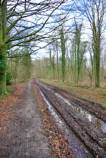
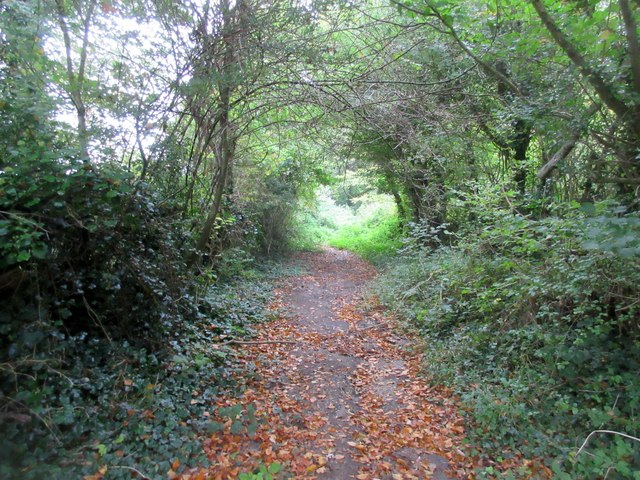
Ide's Common, Sussex is a picturesque woodland area located in the southeastern part of England. Spanning over a vast expanse of land, it is a site of great natural beauty and biodiversity. The woodlands are densely populated with a variety of tree species, including oak, beech, and birch, creating a lush and vibrant environment.

The forest floor is covered in a thick carpet of moss, which adds to the enchanting atmosphere of the area. In spring, the woodland comes alive with a burst of vibrant colors as wildflowers, such as bluebells and primroses, bloom in abundance.

The common is also home to a diverse range of wildlife. It serves as a habitat for numerous bird species, such as woodpeckers and nightingales, which fill the air with their melodious songs. Additionally, the woodlands provide shelter to various small mammals, including foxes, badgers, and squirrels.

The area is a popular destination for nature enthusiasts and hikers, offering a network of well-maintained trails that wind through the woods, providing breathtaking views of the surrounding landscape. These trails also lead to the nearby Ide's Hill, which offers panoramic views of the South Downs National Park.

The common holds significant historical and cultural value as well. It is believed to have been used as a hunting ground by ancient civilizations and was later used as a source of timber for shipbuilding during the medieval period.

Overall, Ide's Common, Sussex is a haven of natural beauty, biodiversity, and historical significance, attracting visitors from near and far who seek to immerse themselves in the tranquility of this stunning woodland area.

If you have any feedback on the listing, please let us know in the comments section below.

Ide's Common Images

Images are sourced within 2km of 50.894724/-0.66897644 or Grid Reference SU9311. Thanks to Geograph Open Source API. All images are credited.

Middle Barn Farm Middle Barn Farm around 1985
Middle Barn Farm
Middle Barn Farm around 1985
Selhurst Park A field of oilseed rape seen from Selhurstpark Road.
Selhurst Park
A field of oilseed rape seen from Selhurstpark Road.
Selhurst Park A field of oilseed rape seen from Selhurstpark Road.  On the top of the hill in the middle distance can be seen Halnaker Windmill (see <a href="https://www.geograph.org.uk/photo/2104890">SU9209 : Halnaker Windmill</a>).
Selhurst Park
A field of oilseed rape seen from Selhurstpark Road. On the top of the hill in the middle distance can be seen Halnaker Windmill (see SU9209 : Halnaker Windmill).
Selhurst Park A field of oilseed rape seen from Selhurstpark Road.  On the top of the hill on the far right of the photo can be seen Halnaker Windmill (see <a href="https://www.geograph.org.uk/photo/2104890">SU9209 : Halnaker Windmill</a>).
Selhurst Park
A field of oilseed rape seen from Selhurstpark Road. On the top of the hill on the far right of the photo can be seen Halnaker Windmill (see SU9209 : Halnaker Windmill).
Memorial at the crash site of a Douglas Skytrain A close up of the memorial marking the crash site of a Douglas Skytrain, more commonly known as an American Dakota, which crashed in poor visibility on 11th February 1945, killing all 7 people on board. The plane had been returning to the UK from Europe on postal duties.

Having taken off from Paris to return to Wiltshire the plane was picked up by the radar at Tangmere airfield, noting that the plane was flying low over the South Downs, in low cloud and fog, on an East/West course. It was subsequently concluded that the pilot had been lost and thought that he was further south flying over the sea, presumably looking for a landmark on the coast to regain their position. Unfortunately, they were flying over a high point of the Downs and crashed on Sutton Down.

The loss of live is additionally marked by the Four Nations War Memorial in the Church nearby in Upwaltham. This also commemorates the loss of the 8 airmen who died when their Avro Lancaster crashed, almost exactly a year previously to the day, on the opposite side of the valley at Crown Tegleaze.
Memorial at the crash site of a Douglas Skytrain
A close up of the memorial marking the crash site of a Douglas Skytrain, more commonly known as an American Dakota, which crashed in poor visibility on 11th February 1945, killing all 7 people on board. The plane had been returning to the UK from Europe on postal duties. Having taken off from Paris to return to Wiltshire the plane was picked up by the radar at Tangmere airfield, noting that the plane was flying low over the South Downs, in low cloud and fog, on an East/West course. It was subsequently concluded that the pilot had been lost and thought that he was further south flying over the sea, presumably looking for a landmark on the coast to regain their position. Unfortunately, they were flying over a high point of the Downs and crashed on Sutton Down. The loss of live is additionally marked by the Four Nations War Memorial in the Church nearby in Upwaltham. This also commemorates the loss of the 8 airmen who died when their Avro Lancaster crashed, almost exactly a year previously to the day, on the opposite side of the valley at Crown Tegleaze.
Track. Eartham Wood Also a public bridleway.
Track. Eartham Wood
Also a public bridleway.
View south-east from Selhurst Wood car park The wooded hill is probably Nore Hill.
View south-east from Selhurst Wood car park
The wooded hill is probably Nore Hill.
View east from Red Copse Looking towards Nore Hill in the distance.
View east from Red Copse
Looking towards Nore Hill in the distance.
Farm buildings, Droke Lane
Footpath from Eartham Wood Monarch's Way follows public footpath 398 towards A285.
Footpath from Eartham Wood
Monarch's Way follows public footpath 398 towards A285.
Footpath through wood Monarch's Way follows public footpath 398 towards A285.
Footpath through wood
Monarch's Way follows public footpath 398 towards A285.
Clearing for overhead power line Viewed from public footpath 398, Monarch's Way.
Clearing for overhead power line
Viewed from public footpath 398, Monarch's Way.
Footpath on edge of Ides Common Monarch's Way follows public footpath 398 towards Eartham Wood.
Footpath on edge of Ides Common
Monarch's Way follows public footpath 398 towards Eartham Wood.
Farm track south of Ides Common Monarch's Way follows public footpath 398 through woods.
Farm track south of Ides Common
Monarch's Way follows public footpath 398 through woods.
Farm track with canopy Monarch's Way follows public footpath 398.
Farm track with canopy
Monarch's Way follows public footpath 398.
Overhead power lines to Middle Barn Farm Viewed from public footpath 398, Monarch's Way.
Overhead power lines to Middle Barn Farm
Viewed from public footpath 398, Monarch's Way.
Overhead power lines crossing Monarch's Way  Monarch's Way follows public footpath 398 towards A285 and Ides Common.
Overhead power lines crossing Monarch's Way
Monarch's Way follows public footpath 398 towards A285 and Ides Common.
Redundant stile Monarch's Way follows public footpath 398 adjacent to ploughed field. OS map appears to show the right of way passing through the corn field to the east of the path. Another example of realignment with actuality.
Redundant stile
Monarch's Way follows public footpath 398 adjacent to ploughed field. OS map appears to show the right of way passing through the corn field to the east of the path. Another example of realignment with actuality.
Show me another place!

Ide's Common is located at Grid Ref: SU9311 (Lat: 50.894724, Lng: -0.66897644)

Administrative County: West Sussex

District: Chichester

Police Authority: Sussex

What 3 Words

///acrobats.snails.harmony. Near Fontwell, West Sussex

Related Wikis

Eartham

Eartham is a village and civil parish in the District of Chichester in West Sussex, England located 8.5 kilometres (5.3 mi) north east of Chichester east...

Great Ballard School

Great Ballard School is a co-educational independent school for children aged 2½ to 16 years. It was founded in 1924 and set up at its current location...

Upwaltham

Upwaltham is a scattered settlement and civil parish in the South Downs, in the District of Chichester of West Sussex, England. It surrounds a parish church...
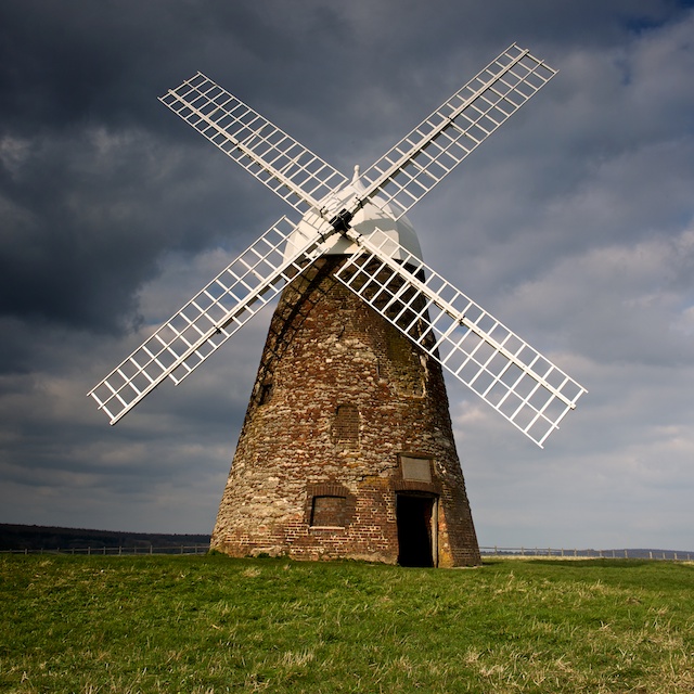
Halnaker Windmill

Halnaker Windmill is a tower mill which stands on Halnaker Hill, northeast of Chichester, Sussex, England. The mill is reached by a public footpath from...

Nearby Amenities

Located within 500m of 50.894724,-0.66897644
Power: pole
Lat/Long: 50.8943174/-0.6757477
Power: pole
Lat/Long: 50.8953545/-0.6758148
Give Way
Direction: forward
Lat/Long: 50.8907933/-0.6710833
The data included in this document is from www.openstreetmap.org. The data is made available under ODbL.

Have you been to Ide's Common?

Leave your review of Ide's Common below (or comments, questions and feedback).