America Wood

Wood, Forest in Lincolnshire

England

America Wood

Road junction at Black Walk Nook
Road junction at Black Walk Nook Credit: David Brown

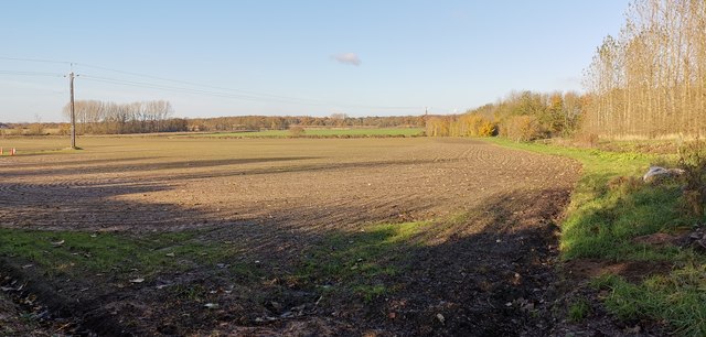
America Wood, located in Lincolnshire, England, is a picturesque forest area encompassing approximately 70 hectares. Nestled in the heart of rural Lincolnshire, it offers visitors a serene and tranquil escape from the bustling city life. The woodland is easily accessible, situated just off the A15 road, making it an ideal destination for nature enthusiasts and locals looking for a peaceful retreat.

The forest is predominantly composed of deciduous trees such as oak, ash, birch, and beech, which create a vibrant and diverse ecosystem. Throughout the year, America Wood showcases a stunning display of colors, with vibrant greens in the spring and summer, followed by a breathtaking array of reds, oranges, and yellows in the autumn.

The forest is also home to various wildlife species, including deer, foxes, rabbits, and a plethora of bird species. This makes America Wood a popular spot for birdwatchers and wildlife photographers, who can capture captivating shots of the local fauna in their natural habitat.

Visitors to America Wood can enjoy a range of activities, from leisurely strolls along its well-maintained trails to more adventurous pursuits such as cycling and horseback riding. The forest also offers picnic areas, providing the perfect setting for a family outing or a peaceful picnic amidst nature.

Overall, America Wood in Lincolnshire is a scenic and tranquil woodland that offers a delightful escape to nature lovers. Its diverse flora and fauna, coupled with its accessibility and range of activities, make it a must-visit destination for both locals and tourists seeking solace and a connection with the natural world.

If you have any feedback on the listing, please let us know in the comments section below.

America Wood Images

Images are sourced within 2km of 53.513378/-0.61230291 or Grid Reference SE9202. Thanks to Geograph Open Source API. All images are credited.

Road junction at Black Walk Nook
Cut Mark: Cleatham, Cleatham Hall Farm Cut bench mark on the south-east angle of a large farm building at Cleatham Hall Farm.  See <a title="https://www.geograph.org.uk/photo/7332574" href="https://www.geograph.org.uk/photo/7332574">Link</a> for a wider view and <span class="nowrap"><a title="https://www.bench-marks.org.uk/bm179252" rel="nofollow ugc noopener" href="https://www.bench-marks.org.uk/bm179252">Link</a><img style="margin-left:2px;" alt="External link" title="External link - shift click to open in new window" src="https://s1.geograph.org.uk/img/external.png" width="10" height="10"/></span> for details of the mark.
Cut Mark: Cleatham, Cleatham Hall Farm
Cut bench mark on the south-east angle of a large farm building at Cleatham Hall Farm. See Link for a wider view and LinkExternal link for details of the mark.
Farm Building at Cleatham Hall Farm There is a cut bench mark on the near angle of this large farm building at Cleatham Hall Farm.  See <a title="https://www.geograph.org.uk/photo/7332571" href="https://www.geograph.org.uk/photo/7332571">Link</a> for a closer view and <span class="nowrap"><a title="https://www.bench-marks.org.uk/bm179252" rel="nofollow ugc noopener" href="https://www.bench-marks.org.uk/bm179252">Link</a><img style="margin-left:2px;" alt="External link" title="External link - shift click to open in new window" src="https://s1.geograph.org.uk/img/external.png" width="10" height="10"/></span> for details of the mark.
Farm Building at Cleatham Hall Farm
There is a cut bench mark on the near angle of this large farm building at Cleatham Hall Farm. See Link for a closer view and LinkExternal link for details of the mark.
Cut Mark on a House at the Junction of Cleatham Road and Manton Road This benchmark is on the angle of the house at the road junction.  It is not listed by the Ordnance Survey but appears on old maps up to 1961.  See <a title="https://www.geograph.org.uk/photo/7332596" href="https://www.geograph.org.uk/photo/7332596">Link</a> for a building view and <span class="nowrap"><a title="https://www.bench-marks.org.uk/bm179254" rel="nofollow ugc noopener" href="https://www.bench-marks.org.uk/bm179254">Link</a><img style="margin-left:2px;" alt="External link" title="External link - shift click to open in new window" src="https://s1.geograph.org.uk/img/external.png" width="10" height="10"/></span> for details of the mark.
Cut Mark on a House at the Junction of Cleatham Road and Manton Road
This benchmark is on the angle of the house at the road junction. It is not listed by the Ordnance Survey but appears on old maps up to 1961. See Link for a building view and LinkExternal link for details of the mark.
House at the Junction of Cleatham Road and Manton Road There is a benchmark is on the angle of the house at the road junction.  It is not listed by the Ordnance Survey but appears on old maps up to 1961.  See <a title="https://www.geograph.org.uk/photo/7332592" href="https://www.geograph.org.uk/photo/7332592">Link</a> for a close view and <span class="nowrap"><a title="https://www.bench-marks.org.uk/bm179254" rel="nofollow ugc noopener" href="https://www.bench-marks.org.uk/bm179254">Link</a><img style="margin-left:2px;" alt="External link" title="External link - shift click to open in new window" src="https://s1.geograph.org.uk/img/external.png" width="10" height="10"/></span> for details of the mark.
House at the Junction of Cleatham Road and Manton Road
There is a benchmark is on the angle of the house at the road junction. It is not listed by the Ordnance Survey but appears on old maps up to 1961. See Link for a close view and LinkExternal link for details of the mark.
Stitched up? Ditch and puddles in field south of Brigg Road, Messingham: aerial 2023 The water-filled ditch marks the position of a former field boundary, the pools seem to suggest truncated ends of ridge and furrow.
Stitched up? Ditch and puddles in field south of Brigg Road, Messingham: aerial 2023
The water-filled ditch marks the position of a former field boundary, the pools seem to suggest truncated ends of ridge and furrow.
Quarry near Manton: aerial 2018
Driveway/Entrance to Cleatham Hall
Road junction near Manton.
Gated track in Black Walk Nook
Black Walk Nook Area of ancient woodland.
Black Walk Nook
Area of ancient woodland.
Drainage ditch near Black Walk Nook
Cleatham Villa
Cleatham Villa
Newly installed 33Kv electricity pylons near Kirton in Lindsey
Farmland at Cheatham
Entrance to Cheatham Hall Now a hotel
Entrance to Cheatham Hall
Now a hotel
Cheatham Hall Now a hotel
Cheatham Hall
Now a hotel
St.Hybald's church, Manton Made redundant by the Church of England's Diocese of Lincoln in 1998, and sold for residential use in 2003.
St.Hybald's church, Manton
Made redundant by the Church of England's Diocese of Lincoln in 1998, and sold for residential use in 2003.
Show me another place!

America Wood is located at Grid Ref: SE9202 (Lat: 53.513378, Lng: -0.61230291)

Unitary Authority: North Lincolnshire

Police Authority: Humberside

What 3 Words

///visits.sheepish.heats. Near Manton, Lincolnshire

Nearby Locations

Manton America Wood

Related Wikis

Manton, Lincolnshire

Manton is a village and civil parish in North Lincolnshire, England. The population of the civil parish at the 2011 census was 123. The village is situated...

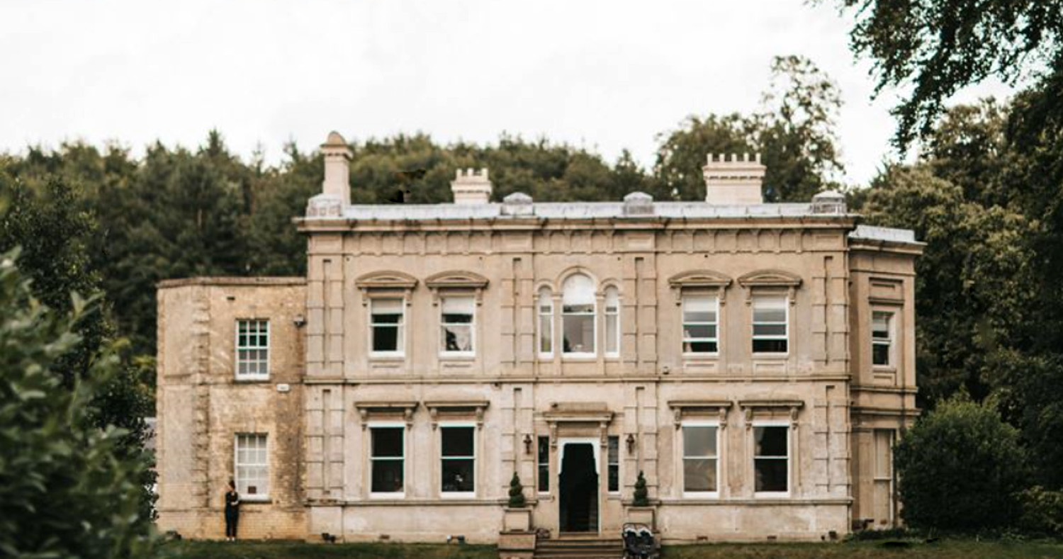
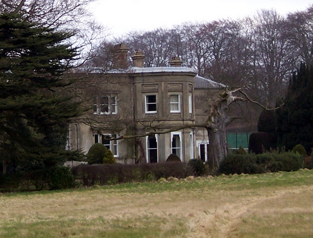
Cleatham Hall, Lincolnshire

Cleatham Hall is an English country house located near Manton in Lincolnshire, England. The building is of special interest and has a Grade II listing...

Messingham

Messingham is a village and civil parish in North Lincolnshire, England. The village is situated on the A159, 4 miles (6 km) south from the centre of Scunthorpe...

Scunthorpe (UK Parliament constituency)

Scunthorpe is a constituency represented in the House of Commons of the UK Parliament since 2019 by Holly Mumby-Croft, a member of the Conservative Party...

Nearby Amenities

Located within 500m of 53.513378,-0.61230291
Power: tower
Lat/Long: 53.5176854/-0.6141039
Generator Method: wind_turbine
Generator Source: wind
Power: generator
Lat/Long: 53.5164939/-0.609709
The data included in this document is from www.openstreetmap.org. The data is made available under ODbL.

Have you been to America Wood?

Leave your review of America Wood below (or comments, questions and feedback).