Cottesmore Wood

Wood, Forest in Rutland

England

Cottesmore Wood

St. Nicholas, Cottesmore Grade II Listed

The current church mostly dates from the 13th and 14th centuries, and is built of stone from Clipsham, which is nearby. The tower dates to the 14th century. In the northern wall some 12th-century stonework can be seen.


<span class="nowrap"><a title="https://en.wikipedia.org/wiki/St_Nicholas%27_Church,_Cottesmore" rel="nofollow ugc noopener" href="https://en.wikipedia.org/wiki/St_Nicholas%27_Church,_Cottesmore">Link</a><img style="margin-left:2px;" alt="External link" title="External link - shift click to open in new window" src="https://s1.geograph.org.uk/img/external.png" width="10" height="10"/></span>
St. Nicholas, Cottesmore Credit: Brian Deegan

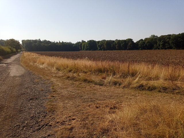
Cottesmore Wood is a picturesque woodland located in the county of Rutland, England. Spanning an area of approximately 150 acres, it is renowned for its natural beauty and diverse wildlife. The wood is situated near the village of Cottesmore, in close proximity to the bustling market town of Oakham.

The wood is predominantly composed of native broadleaf trees, such as oak, ash, and birch. These majestic trees create a dense canopy, providing a habitat for a wide range of flora and fauna. Bluebells carpet the forest floor in the spring, creating a stunning display of vibrant colors. The wood is also home to a variety of wildlife, including deer, badgers, foxes, and a plethora of bird species.

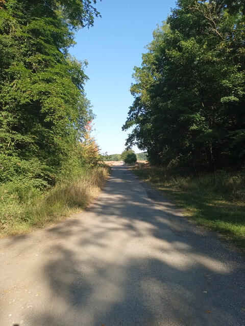
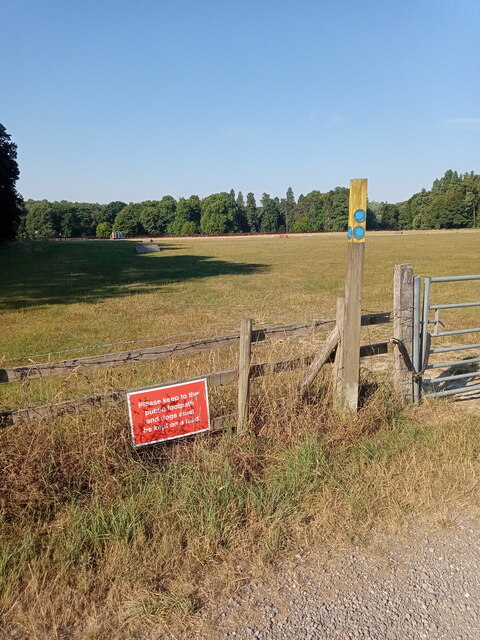
Cottesmore Wood is a popular destination for nature lovers, walkers, and wildlife enthusiasts. It offers a network of well-maintained footpaths, allowing visitors to explore the wood at their leisure. The serene atmosphere and tranquil setting make it an ideal location for relaxation and contemplation.

Managed by the Forestry Commission, Cottesmore Wood is also an important site for conservation and sustainable forest management. The Commission ensures that the wood is carefully preserved, balancing the needs of wildlife with the enjoyment of visitors.

Overall, Cottesmore Wood in Rutland is a natural haven where visitors can immerse themselves in the beauty of nature, observe diverse wildlife, and enjoy peaceful walks amidst an enchanting woodland setting.

If you have any feedback on the listing, please let us know in the comments section below.

Cottesmore Wood Images

Images are sourced within 2km of 52.706829/-0.64422844 or Grid Reference SK9112. Thanks to Geograph Open Source API. All images are credited.

St. Nicholas, Cottesmore Grade II Listed

The current church mostly dates from the 13th and 14th centuries, and is built of stone from Clipsham, which is nearby. The tower dates to the 14th century. In the northern wall some 12th-century stonework can be seen.


<span class="nowrap"><a title="https://en.wikipedia.org/wiki/St_Nicholas%27_Church,_Cottesmore" rel="nofollow ugc noopener" href="https://en.wikipedia.org/wiki/St_Nicholas%27_Church,_Cottesmore">Link</a><img style="margin-left:2px;" alt="External link" title="External link - shift click to open in new window" src="https://s1.geograph.org.uk/img/external.png" width="10" height="10"/></span>
St. Nicholas, Cottesmore
Grade II Listed The current church mostly dates from the 13th and 14th centuries, and is built of stone from Clipsham, which is nearby. The tower dates to the 14th century. In the northern wall some 12th-century stonework can be seen. LinkExternal link
Cottage at the end of the Leas
Cottesmore The pub sign by the bus stop is for the pub on this side of the B668 road (<a href="https://www.geograph.org.uk/photo/6901001">SK9013 : The famous sun</a>).
Cottesmore
The pub sign by the bus stop is for the pub on this side of the B668 road (SK9013 : The famous sun).
The Leas A short curved road parallel to the village main street.
The Leas
A short curved road parallel to the village main street.
The Village Shop and Church, what more does a Village need?
The Village
Shop and Church, what more does a Village need?
Cottages under the trees A grade II building of 1775 - see <span class="nowrap"><a title="https://historicengland.org.uk/listing/the-list/list-entry/1177099" rel="nofollow ugc noopener" href="https://historicengland.org.uk/listing/the-list/list-entry/1177099">Link</a><img style="margin-left:2px;" alt="External link" title="External link - shift click to open in new window" src="https://s1.geograph.org.uk/img/external.png" width="10" height="10"/></span>
Cottages under the trees
A grade II building of 1775 - see LinkExternal link
Commonwealth war graves, Cottesmore Mainly of Canadian and Australian servicemen.
Commonwealth war graves, Cottesmore
Mainly of Canadian and Australian servicemen.
War graves, Cottesmore Mainly of post WW2 British service personnel.
War graves, Cottesmore
Mainly of post WW2 British service personnel.
Cemetery extension, Cottesmore
Autumn sown crop off Rogue's Lane, Cottesmore
Field beside the footpath Next to a decent track for cycling on.
Field beside the footpath
Next to a decent track for cycling on.
Path, north of Exton Park Facing north west.
Path, north of Exton Park
Facing north west.
Field with jumps Several horse jumps are dotted around the field beyond the sign.
Field with jumps
Several horse jumps are dotted around the field beyond the sign.
The Plough, Main Street, Greetham
Church Lane, Greetham Seen from Main Street. The Grade II Listed Village Well is on the left under the tree. <span class="nowrap"><a title="https://historicengland.org.uk/listing/the-list/list-entry/1073219" rel="nofollow ugc noopener" href="https://historicengland.org.uk/listing/the-list/list-entry/1073219">Link</a><img style="margin-left:2px;" alt="External link" title="External link - shift click to open in new window" src="https://s1.geograph.org.uk/img/external.png" width="10" height="10"/></span>
Church Lane, Greetham
Seen from Main Street. The Grade II Listed Village Well is on the left under the tree. LinkExternal link
Former Chapel, Main Street, Greetham Former Primitive Methodist Chapel opened in 1889, as indicated by the datestone at the top of the gable and closed in 1960. I don't know what its use was in 2009 when the image was taken, but in 2014 it was being used as 2 garages. <span class="nowrap"><a title="https://www.myprimitivemethodists.org.uk/content/chapels/rutland/greetham_primitive_methodist_chapel" rel="nofollow ugc noopener" href="https://www.myprimitivemethodists.org.uk/content/chapels/rutland/greetham_primitive_methodist_chapel">Link</a><img style="margin-left:2px;" alt="External link" title="External link - shift click to open in new window" src="https://s1.geograph.org.uk/img/external.png" width="10" height="10"/></span>
Former Chapel, Main Street, Greetham
Former Primitive Methodist Chapel opened in 1889, as indicated by the datestone at the top of the gable and closed in 1960. I don't know what its use was in 2009 when the image was taken, but in 2014 it was being used as 2 garages. LinkExternal link
Wooden Bus Shelter, Main Street, Greetham This image was taken in October 2009. Google Street View from May 2021 shows a new, more open shelter which will not give as much protection in bad weather, but it does have a bench seat inside.
Wooden Bus Shelter, Main Street, Greetham
This image was taken in October 2009. Google Street View from May 2021 shows a new, more open shelter which will not give as much protection in bad weather, but it does have a bench seat inside.
The Thatch, 5 Main Street, Cottesmore Grade II Listed 18th century cottage. This is a grade II listed 18th century thatched cottage. Mr H D Smith, headmaster of the Central School lived here in the 1930s. He also lived at Ivy Cottage next door.
The Thatch, 5 Main Street, Cottesmore
Grade II Listed 18th century cottage. This is a grade II listed 18th century thatched cottage. Mr H D Smith, headmaster of the Central School lived here in the 1930s. He also lived at Ivy Cottage next door.
Show me another place!

Cottesmore Wood is located at Grid Ref: SK9112 (Lat: 52.706829, Lng: -0.64422844)

Unitary Authority: Rutland

Police Authority: Leicestershire

What 3 Words

///lofts.conquests.secures. Near Cottesmore, Rutland

Related Wikis

Cottesmore, Rutland

Cottesmore (often pronounced Cotts'more) is a village and civil parish in the north of the county of Rutland in the East Midlands of England. In terms...

St Nicholas' Church, Cottesmore

St Nicholas' Church is a church in Cottesmore, Rutland. It is a Grade II* listed building.The Cottesmore Benefice is part of the North Rutland Churches...

Cottesmore Amateurs F.C.

Cottesmore AFC (formerly known as Cottesmore Amateurs FC) is a football club based in Cottesmore, Rutland, England. They are currently members of the Leicestershire...

Exton Hall

Exton Hall is an English country house on the western edge of the village of Exton, Rutland, England, standing in its own extensive park, and is the country...

Related Videos

Rocks By Rail Museum - Quarry Shunting Spring Bank Holiday 2023

Shunting the quarry at the Rocks By Rail Museum Spring Bank Holiday 2023 operating day. See close up shunting movements ...

Exton Village Walk, English Countryside 4K

https://www.buymeacoffee.com/Daveswalks All support is hugely appreciated and it helps me keep the channel going! No talking ...

Rocks By Rail Museum - Ruston Bucyrus 22 Dragline excavator Bank Holiday 2023

Watching the Ruston Bucyrus 22 Dragline excavator at the Rocks By Rail Museum Spring Bank Holiday 2023 operating day.

Exton Walk FORT HENRY Exton dog walk , Rutland area walk

Exton walk in Rutland County UK visiting lake and Fort William building I can provide GPX file for this walk for your gps devices I ...

Nearby Amenities

Located within 500m of 52.706829,-0.64422844
The data included in this document is from www.openstreetmap.org. The data is made available under ODbL.

Have you been to Cottesmore Wood?

Leave your review of Cottesmore Wood below (or comments, questions and feedback).