East Morton
Settlement in Yorkshire
England
East Morton
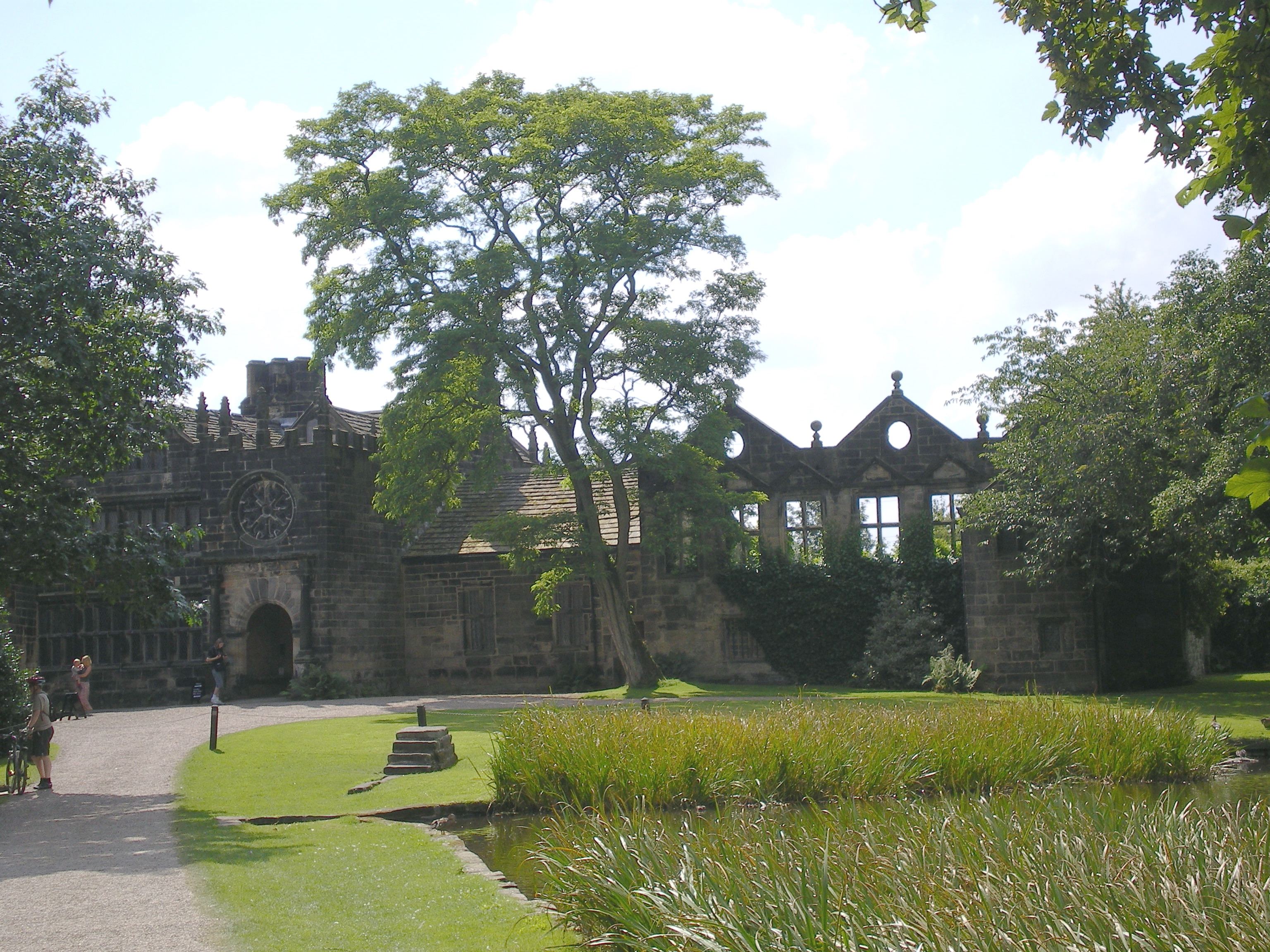
![East Riddlesden Hall and grounds [1] The south front of the hall.
Built on the site of an earlier building, the hall was erected in the 1640s and added to in 1692. Constructed of ashlar under stone slate roofs, the hall has two two-storey porches with wheel (or Yorkshire rose) windows. Many original internal features and fittings remain. Listed, grade I, with details at:
<span class="nowrap"><a title="https://historicengland.org.uk/listing/the-list/list-entry/1283478" rel="nofollow ugc noopener" href="https://historicengland.org.uk/listing/the-list/list-entry/1283478">Link</a><img style="margin-left:2px;" alt="External link" title="External link - shift click to open in new window" src="https://s1.geograph.org.uk/img/external.png" width="10" height="10"/></span>
East Riddlesden Hall is sited on the banks of the River Aire, in Riddlesden, about 1¼ miles northeast of Keighley. Once the centre of a thriving agricultural estate, the grounds of the hall include a tithe barn. Saved from demolition by two local men in 1934, the house and grounds are now in the care of the National Trust.](https://s3.geograph.org.uk/geophotos/07/02/14/7021447_f9e03490.jpg)
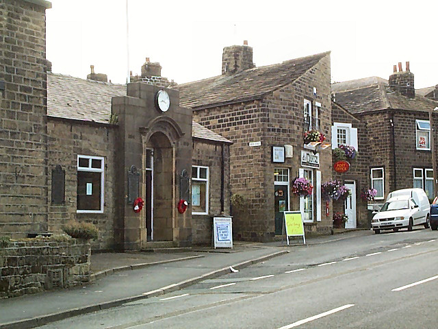
East Morton is a quaint village located in the metropolitan county of West Yorkshire, England. Situated approximately 4 miles west of the market town of Keighley, East Morton is nestled in the Aire Valley, surrounded by picturesque countryside and rolling hills.
The village is renowned for its charming character and traditional stone-built houses, which give it a distinct Yorkshire feel. It is home to a close-knit community, with a population of around 2,000 residents. The village boasts a range of amenities, including a primary school, a village hall, a post office, and a local pub, which serves as a popular gathering place for locals and visitors alike.
East Morton is also known for its beautiful green spaces, such as East Morton Park, which offers a tranquil retreat for nature enthusiasts. The park features well-maintained walking trails, a children's play area, and ample space for picnics and outdoor activities. Additionally, the village benefits from its proximity to the Leeds and Liverpool Canal, providing opportunities for leisurely walks and boat trips.
The village holds a rich history, with its origins dating back to the 12th century. It has managed to retain much of its historic charm, with notable landmarks such as East Morton Hall, a Grade II listed building. The village also hosts annual events, such as a summer fair and a Christmas market, which further contribute to its vibrant community spirit.
Overall, East Morton offers a peaceful and idyllic setting, combining natural beauty, historical significance, and a strong sense of community. It is a desirable place to live for those seeking a rural retreat while still being within easy reach of nearby towns and cities.
If you have any feedback on the listing, please let us know in the comments section below.
East Morton Images
Images are sourced within 2km of 53.874562/-1.853192 or Grid Reference SE0942. Thanks to Geograph Open Source API. All images are credited.
![East Riddlesden Hall and grounds [2] The entrance porch in the south front.
Built on the site of an earlier building, the hall was erected in the 1640s and added to in 1692. Constructed of ashlar under stone slate roofs, the hall has two two-storey porches with wheel (or Yorkshire rose) windows. Many original internal features and fittings remain. Listed, grade I, with details at:
<span class="nowrap"><a title="https://historicengland.org.uk/listing/the-list/list-entry/1283478" rel="nofollow ugc noopener" href="https://historicengland.org.uk/listing/the-list/list-entry/1283478">Link</a><img style="margin-left:2px;" alt="External link" title="External link - shift click to open in new window" src="https://s1.geograph.org.uk/img/external.png" width="10" height="10"/></span>
East Riddlesden Hall is sited on the banks of the River Aire, in Riddlesden, about 1¼ miles northeast of Keighley. Once the centre of a thriving agricultural estate, the grounds of the hall include a tithe barn. Saved from demolition by two local men in 1934, the house and grounds are now in the care of the National Trust.](https://s3.geograph.org.uk/geophotos/07/02/14/7021451_f4beef7d.jpg)
![East Riddlesden Hall and grounds [3] The north front of the hall.
Built on the site of an earlier building, the hall was erected in the 1640s and added to in 1692. Constructed of ashlar under stone slate roofs, the hall has two two-storey porches with wheel (or Yorkshire rose) windows. Many original internal features and fittings remain. Listed, grade I, with details at:
<span class="nowrap"><a title="https://historicengland.org.uk/listing/the-list/list-entry/1283478" rel="nofollow ugc noopener" href="https://historicengland.org.uk/listing/the-list/list-entry/1283478">Link</a><img style="margin-left:2px;" alt="External link" title="External link - shift click to open in new window" src="https://s1.geograph.org.uk/img/external.png" width="10" height="10"/></span>
East Riddlesden Hall is sited on the banks of the River Aire, in Riddlesden, about 1¼ miles northeast of Keighley. Once the centre of a thriving agricultural estate, the grounds of the hall include a tithe barn. Saved from demolition by two local men in 1934, the house and grounds are now in the care of the National Trust.](https://s2.geograph.org.uk/geophotos/07/02/14/7021454_c4022af1.jpg)
![East Riddlesden Hall and grounds [4] The south front of the hall.
Built on the site of an earlier building, the hall was erected in the 1640s and added to in 1692. Constructed of ashlar under stone slate roofs, the hall has two two-storey porches with wheel (or Yorkshire rose) windows. Many original internal features and fittings remain. Listed, grade I, with details at:
<span class="nowrap"><a title="https://historicengland.org.uk/listing/the-list/list-entry/1283478" rel="nofollow ugc noopener" href="https://historicengland.org.uk/listing/the-list/list-entry/1283478">Link</a><img style="margin-left:2px;" alt="External link" title="External link - shift click to open in new window" src="https://s1.geograph.org.uk/img/external.png" width="10" height="10"/></span>
East Riddlesden Hall is sited on the banks of the River Aire, in Riddlesden, about 1¼ miles northeast of Keighley. Once the centre of a thriving agricultural estate, the grounds of the hall include a tithe barn. Saved from demolition by two local men in 1934, the house and grounds are now in the care of the National Trust.](https://s3.geograph.org.uk/geophotos/07/02/14/7021455_f86a2c1a.jpg)
![East Riddlesden Hall and grounds [5] One of the rooms of the hall.
Built on the site of an earlier building, the hall was erected in the 1640s and added to in 1692. Constructed of ashlar under stone slate roofs, the hall has two two-storey porches with wheel (or Yorkshire rose) windows. Many original internal features and fittings remain. Listed, grade I, with details at:
<span class="nowrap"><a title="https://historicengland.org.uk/listing/the-list/list-entry/1283478" rel="nofollow ugc noopener" href="https://historicengland.org.uk/listing/the-list/list-entry/1283478">Link</a><img style="margin-left:2px;" alt="External link" title="External link - shift click to open in new window" src="https://s1.geograph.org.uk/img/external.png" width="10" height="10"/></span>
East Riddlesden Hall is sited on the banks of the River Aire, in Riddlesden, about 1¼ miles northeast of Keighley. Once the centre of a thriving agricultural estate, the grounds of the hall include a tithe barn. Saved from demolition by two local men in 1934, the house and grounds are now in the care of the National Trust.](https://s3.geograph.org.uk/geophotos/07/02/14/7021459_7feb94f1.jpg)
![East Riddlesden Hall and grounds [6] One of the rooms of the hall.
Built on the site of an earlier building, the hall was erected in the 1640s and added to in 1692. Constructed of ashlar under stone slate roofs, the hall has two two-storey porches with wheel (or Yorkshire rose) windows. Many original internal features and fittings remain. Listed, grade I, with details at:
<span class="nowrap"><a title="https://historicengland.org.uk/listing/the-list/list-entry/1283478" rel="nofollow ugc noopener" href="https://historicengland.org.uk/listing/the-list/list-entry/1283478">Link</a><img style="margin-left:2px;" alt="External link" title="External link - shift click to open in new window" src="https://s1.geograph.org.uk/img/external.png" width="10" height="10"/></span>
East Riddlesden Hall is sited on the banks of the River Aire, in Riddlesden, about 1¼ miles northeast of Keighley. Once the centre of a thriving agricultural estate, the grounds of the hall include a tithe barn. Saved from demolition by two local men in 1934, the house and grounds are now in the care of the National Trust.](https://s2.geograph.org.uk/geophotos/07/02/14/7021462_a66091ac.jpg)
![East Riddlesden Hall and grounds [7] The remains of a wing added in 1708 and demolished in 1905.
Built on the site of an earlier building, the hall was erected in the 1640s and added to in 1692. Constructed of ashlar under stone slate roofs, the hall has two two-storey porches with wheel (or Yorkshire rose) windows. Many original internal features and fittings remain. Listed, grade I, with details at:
<span class="nowrap"><a title="https://historicengland.org.uk/listing/the-list/list-entry/1283478" rel="nofollow ugc noopener" href="https://historicengland.org.uk/listing/the-list/list-entry/1283478">Link</a><img style="margin-left:2px;" alt="External link" title="External link - shift click to open in new window" src="https://s1.geograph.org.uk/img/external.png" width="10" height="10"/></span>
East Riddlesden Hall is sited on the banks of the River Aire, in Riddlesden, about 1¼ miles northeast of Keighley. Once the centre of a thriving agricultural estate, the grounds of the hall include a tithe barn. Saved from demolition by two local men in 1934, the house and grounds are now in the care of the National Trust.](https://s0.geograph.org.uk/geophotos/07/02/14/7021476_84ab1d01.jpg)
![East Riddlesden Hall and grounds [8] Dated 1642, this outbuilding is now used as a National Trust shop. Originally, possibly, the building was a range of guest accommodation. Constructed of ashlar under a stone slate roof. Listed, grade II, with details at: <span class="nowrap"><a title="https://historicengland.org.uk/listing/the-list/list-entry/1283458" rel="nofollow ugc noopener" href="https://historicengland.org.uk/listing/the-list/list-entry/1283458">Link</a><img style="margin-left:2px;" alt="External link" title="External link - shift click to open in new window" src="https://s1.geograph.org.uk/img/external.png" width="10" height="10"/></span>
East Riddlesden Hall is sited on the banks of the River Aire, in Riddlesden, about 1¼ miles northeast of Keighley. Once the centre of a thriving agricultural estate, the grounds of the hall include a tithe barn. Saved from demolition by two local men in 1934, the house and grounds are now in the care of the National Trust.](https://s0.geograph.org.uk/geophotos/07/02/14/7021488_46ad888b.jpg)
![East Riddlesden Hall and grounds [9] This 17th century outbuilding is now used as visitor toilets.
Constructed of squared, coursed stone under a stone slate roof. Listed, grade II, with details at: <span class="nowrap"><a title="https://historicengland.org.uk/listing/the-list/list-entry/1313909" rel="nofollow ugc noopener" href="https://historicengland.org.uk/listing/the-list/list-entry/1313909">Link</a><img style="margin-left:2px;" alt="External link" title="External link - shift click to open in new window" src="https://s1.geograph.org.uk/img/external.png" width="10" height="10"/></span>
East Riddlesden Hall is sited on the banks of the River Aire, in Riddlesden, about 1¼ miles northeast of Keighley. Once the centre of a thriving agricultural estate, the grounds of the hall include a tithe barn. Saved from demolition by two local men in 1934, the house and grounds are now in the care of the National Trust.](https://s3.geograph.org.uk/geophotos/07/02/14/7021495_fb5e6497.jpg)
![East Riddlesden Hall and grounds [10] This double-sided mounting block is set on the south edge of the lake. Probably 17th century of stone. Listed, grade II, with details at: <span class="nowrap"><a title="https://historicengland.org.uk/listing/the-list/list-entry/1199281" rel="nofollow ugc noopener" href="https://historicengland.org.uk/listing/the-list/list-entry/1199281">Link</a><img style="margin-left:2px;" alt="External link" title="External link - shift click to open in new window" src="https://s1.geograph.org.uk/img/external.png" width="10" height="10"/></span>
East Riddlesden Hall is sited on the banks of the River Aire, in Riddlesden, about 1¼ miles northeast of Keighley. Once the centre of a thriving agricultural estate, the grounds of the hall include a tithe barn. Saved from demolition by two local men in 1934, the house and grounds are now in the care of the National Trust.](https://s3.geograph.org.uk/geophotos/07/02/14/7021499_d71413eb.jpg)
![East Riddlesden Hall and grounds [11] Two members of the lawn mowing gang.
East Riddlesden Hall is sited on the banks of the River Aire, in Riddlesden, about 1¼ miles northeast of Keighley. Once the centre of a thriving agricultural estate, the grounds of the hall include a tithe barn. Saved from demolition by two local men in 1934, the house and grounds are now in the care of the National Trust.](https://s1.geograph.org.uk/geophotos/07/02/15/7021501_cd39a29f.jpg)
![East Riddlesden Hall and grounds [12] Part of the gardens of the hall.
East Riddlesden Hall is sited on the banks of the River Aire, in Riddlesden, about 1¼ miles northeast of Keighley. Once the centre of a thriving agricultural estate, the grounds of the hall include a tithe barn. Saved from demolition by two local men in 1934, the house and grounds are now in the care of the National Trust.](https://s3.geograph.org.uk/geophotos/07/02/22/7022235_1dc19589.jpg)
![East Riddlesden Hall and grounds [13] Part of the gardens of the hall.
East Riddlesden Hall is sited on the banks of the River Aire, in Riddlesden, about 1¼ miles northeast of Keighley. Once the centre of a thriving agricultural estate, the grounds of the hall include a tithe barn. Saved from demolition by two local men in 1934, the house and grounds are now in the care of the National Trust.](https://s0.geograph.org.uk/geophotos/07/02/22/7022236_d4d0e3fd.jpg)
![East Riddlesden Hall and grounds [14] Part of the gardens of the hall.
East Riddlesden Hall is sited on the banks of the River Aire, in Riddlesden, about 1¼ miles northeast of Keighley. Once the centre of a thriving agricultural estate, the grounds of the hall include a tithe barn. Saved from demolition by two local men in 1934, the house and grounds are now in the care of the National Trust.](https://s1.geograph.org.uk/geophotos/07/02/22/7022237_75dc8d4d.jpg)
![East Riddlesden Hall and grounds [15] A bird feeding station in the gardens of the hall.
East Riddlesden Hall is sited on the banks of the River Aire, in Riddlesden, about 1¼ miles northeast of Keighley. Once the centre of a thriving agricultural estate, the grounds of the hall include a tithe barn. Saved from demolition by two local men in 1934, the house and grounds are now in the care of the National Trust.](https://s2.geograph.org.uk/geophotos/07/02/22/7022238_03da4416.jpg)
![East Riddlesden Hall and grounds [16] The gate piers at the entrance to the hall. These fine piers are probably late 17th century and are listed, grade II, with details at: <span class="nowrap"><a title="https://historicengland.org.uk/listing/the-list/list-entry/1313910" rel="nofollow ugc noopener" href="https://historicengland.org.uk/listing/the-list/list-entry/1313910">Link</a><img style="margin-left:2px;" alt="External link" title="External link - shift click to open in new window" src="https://s1.geograph.org.uk/img/external.png" width="10" height="10"/></span>
East Riddlesden Hall is sited on the banks of the River Aire, in Riddlesden, about 1¼ miles northeast of Keighley. Once the centre of a thriving agricultural estate, the grounds of the hall include a tithe barn. Saved from demolition by two local men in 1934, the house and grounds are now in the care of the National Trust.](https://s3.geograph.org.uk/geophotos/07/02/22/7022239_8e1aba27.jpg)
![East Riddlesden Hall and grounds [17] Alongside the entrance to the grounds stands this barn. Built in the 17th century of coursed stone under a stone slate roof. The Queen Post roof is a later alteration. Listed, grade II, with details at: <span class="nowrap"><a title="https://historicengland.org.uk/listing/the-list/list-entry/1199343" rel="nofollow ugc noopener" href="https://historicengland.org.uk/listing/the-list/list-entry/1199343">Link</a><img style="margin-left:2px;" alt="External link" title="External link - shift click to open in new window" src="https://s1.geograph.org.uk/img/external.png" width="10" height="10"/></span>
East Riddlesden Hall is sited on the banks of the River Aire, in Riddlesden, about 1¼ miles northeast of Keighley. Once the centre of a thriving agricultural estate, the grounds of the hall include a tithe barn. Saved from demolition by two local men in 1934, the house and grounds are now in the care of the National Trust.](https://s1.geograph.org.uk/geophotos/07/02/22/7022241_b6a19ca6.jpg)
![East Riddlesden Hall and grounds [18] This magnificent aisled barn, with its two pairs of arched and gabled wagon entrances, was built in the late 17th century. Constructed of coursed stone under a stone slate roof on King Post trusses. Listed, grade I, with details at: <span class="nowrap"><a title="https://historicengland.org.uk/listing/the-list/list-entry/1134153" rel="nofollow ugc noopener" href="https://historicengland.org.uk/listing/the-list/list-entry/1134153">Link</a><img style="margin-left:2px;" alt="External link" title="External link - shift click to open in new window" src="https://s1.geograph.org.uk/img/external.png" width="10" height="10"/></span>
East Riddlesden Hall is sited on the banks of the River Aire, in Riddlesden, about 1¼ miles northeast of Keighley. Once the centre of a thriving agricultural estate, the grounds of the hall include a tithe barn. Saved from demolition by two local men in 1934, the house and grounds are now in the care of the National Trust.](https://s2.geograph.org.uk/geophotos/07/02/22/7022242_55fa82ed.jpg)
East Morton is located at Grid Ref: SE0942 (Lat: 53.874562, Lng: -1.853192)
Division: West Riding
Unitary Authority: Bradford
Police Authority: West Yorkshire
What 3 Words
///verve.liners.pixel. Near Bingley, West Yorkshire
Nearby Locations
Related Wikis
East Morton
East Morton is a small village which lies 2 miles (3 km) north of Bingley and 2.5 miles (4 km) east of Keighley, in the county of West Yorkshire, England...
Keighley East
Keighley East (population 14,929 - 2001 UK census) is a ward within the City of Bradford Metropolitan District Council in the county of West Yorkshire...

Crossflatts
Crossflatts is a ribbon development in Airedale along the old route of the A650 road between Bingley and Keighley, in the Metropolitan Borough of Bradford...
East Riddlesden Hall
East Riddlesden Hall is a 17th-century manor house in Keighley, West Yorkshire, England, now owned by the National Trust. == History == The hall was built...
Nearby Amenities
Located within 500m of 53.874562,-1.853192Have you been to East Morton?
Leave your review of East Morton below (or comments, questions and feedback).