Longrove Plantations

Wood, Forest in Buckinghamshire

England

Longrove Plantations

Farmland, Hughenden The footpath heading towards Great Moseley Farm crossing an arable field.
Farmland, Hughenden Credit: Andrew Smith

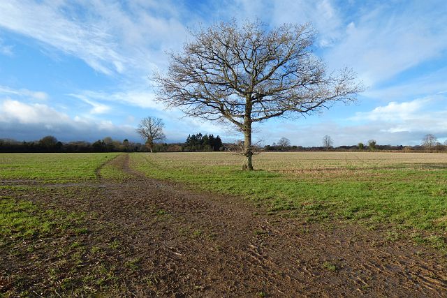
Longrove Plantations is a picturesque woodland area located in Buckinghamshire, England. Nestled in the heart of the county, this enchanting forest covers a vast expanse of land, providing a serene retreat for nature enthusiasts and outdoor enthusiasts alike.

The plantation is known for its dense population of various tree species, including oak, beech, and birch, which create a stunning canopy of green. The woodlands are meticulously maintained, with well-marked trails that wind their way through the trees, offering visitors the opportunity to explore and immerse themselves in the beauty of nature.

Longrove Plantations is also home to a diverse range of wildlife, making it a haven for nature lovers. Visitors might spot deer grazing peacefully among the trees, or hear the delightful chirping of birds as they flit from branch to branch. The plantation's commitment to preserving the natural habitat has resulted in a flourishing ecosystem, attracting a multitude of species.

Aside from its natural wonders, Longrove Plantations boasts several amenities designed to enhance visitors' experiences. There are picnic areas scattered throughout the forest, offering a tranquil setting for a family outing or a peaceful lunch amidst nature. Additionally, there are well-maintained restroom facilities and ample parking for visitors.

Whether one seeks a peaceful stroll through the woods, a chance to observe wildlife in their natural habitat, or simply a break from the hustle and bustle of everyday life, Longrove Plantations in Buckinghamshire is an idyllic destination that offers a true escape into nature.

If you have any feedback on the listing, please let us know in the comments section below.

Longrove Plantations Images

Images are sourced within 2km of 51.671458/-0.75212039 or Grid Reference SU8697. Thanks to Geograph Open Source API. All images are credited.

Farmland, Hughenden The footpath heading towards Great Moseley Farm crossing an arable field.
Farmland, Hughenden
The footpath heading towards Great Moseley Farm crossing an arable field.
The Basil & Thyme/ Lounge India Restaurants, Great Kingshill Situated in Missenden Road HP15 6EB, this brick and flint building used to be the Red Lion public house until it closed a few years ago, then refurbished. It reopened on Monday 31st May 2021 as the Basil & Thyme Restaurant plus Lounge India Restaurant and takeaway. The Lounge India pub sign can be seen on the extreme right of the photo.
The Basil & Thyme/ Lounge India Restaurants, Great Kingshill
Situated in Missenden Road HP15 6EB, this brick and flint building used to be the Red Lion public house until it closed a few years ago, then refurbished. It reopened on Monday 31st May 2021 as the Basil & Thyme Restaurant plus Lounge India Restaurant and takeaway. The Lounge India pub sign can be seen on the extreme right of the photo.
Coombe Lane at the junction of Westwood Drive
Hunts Hill Lane at the junction of Coombe Lane
Hunts Hill Lane, Naphill
Coombe Lane, Hughenden Valley From Valley Road
Coombe Lane, Hughenden Valley
From Valley Road
Valley Road, Hughenden Valley
Coombe Lane, Hughenden Valley At the junction of Burnham Road.
Coombe Lane, Hughenden Valley
At the junction of Burnham Road.
Main Road, Naphill
Main Road, Naphill
Tree on Bryants Bottom Road
Bryants Bottom Road, Hughenden Valley
Rural scene in Hughenden Valley
Valley Road, Hughenden Valley
Pasture, Hughenden Fields between Great Kingshill and Widmer End are seen from one of the area's many footpaths.
Pasture, Hughenden
Fields between Great Kingshill and Widmer End are seen from one of the area's many footpaths.
Label on top of decorated postbox, Heath End This label is attached to the knitted crown on top of the post box in Heath End Road near St Margaret's Grove. It has the following wording:

                                       Made with love
                                        for our village
                                                ♥
                               GK Postbox Topper Ladies

   Incidentally, GK stands for Great Kingshill which is adjacent to Heath End.
Label on top of decorated postbox, Heath End
This label is attached to the knitted crown on top of the post box in Heath End Road near St Margaret's Grove. It has the following wording: Made with love for our village ♥ GK Postbox Topper Ladies Incidentally, GK stands for Great Kingshill which is adjacent to Heath End.
Decorated Post Box in Heath End This Elizabeth II postbox is located in Heath End Road HP15 6HL and has a knitted crown on its top to commemorate the coronation of King Charles III on Saturday 6th May 2023. The wording on the label below the top is at <a title="https://www.geograph.org.uk/photo/7479279" href="https://www.geograph.org.uk/photo/7479279">Link</a>. St Margaret's Road can just be seen to the left of the postbox.
Decorated Post Box in Heath End
This Elizabeth II postbox is located in Heath End Road HP15 6HL and has a knitted crown on its top to commemorate the coronation of King Charles III on Saturday 6th May 2023. The wording on the label below the top is at Link. St Margaret's Road can just be seen to the left of the postbox.
Decorated Post Box in Great Kingshill Situated on the A4128 Missenden Road, this EIIR post box is decorated with seashore items on 
the top including a seagull, and bucket and spade. Round the side and back of the box is a collage of fish swimming in the sea. A wooden shelter can be seen behind the postbox.
Decorated Post Box in Great Kingshill
Situated on the A4128 Missenden Road, this EIIR post box is decorated with seashore items on the top including a seagull, and bucket and spade. Round the side and back of the box is a collage of fish swimming in the sea. A wooden shelter can be seen behind the postbox.
Show me another place!

Longrove Plantations is located at Grid Ref: SU8697 (Lat: 51.671458, Lng: -0.75212039)

Unitary Authority: Buckinghamshire

Police Authority: Thames Valley

What 3 Words

///symphonic.regaining.shin. Near High Wycombe, Buckinghamshire

Related Wikis

Pipers Corner School

Pipers Corner School is a private independent day school for girls in Great Kingshill, Buckinghamshire, England. There are 605 pupils aged from 4 to 18...

Prestwood Local Nature Reserve

Prestwood Local Nature Reserve or Prestwood (Picnic Site) is a 2.1 hectares (5.2 acres) Local Nature Reserve in Prestwood in Buckinghamshire. It is in...

Cryers Hill

Cryers Hill is a hamlet in the parish of Hughenden and in Buckinghamshire, England. It was formerly known as Ravensmere (sometimes 'Ravening'). The hamlet...

Great Kingshill

Great Kingshill is a small village in the parish of Hughenden in Buckinghamshire, England. It is located in the Chiltern Hills, about five miles west...

Nearby Amenities

Located within 500m of 51.671458,-0.75212039
Crossing: informal
Lat/Long: 51.6701961/-0.7566548
Pub
The Harrow
Addr City: Hughenden Valley
Addr Housenumber: 62
Addr Postcode: HP14 4LX
Addr Street: Warrendene Road
Contact Facebook: https://www.facebook.com/The-Harrow-Pub-847079525409577/
Fhrs Id: 486256
Food: yes
Internet Access: wlan
Internet Access Fee: no
Phone: +44 1494 564105
Smoking: outside
Source: FHRS
Toilets: yes
Toilets Wheelchair: yes
Website: https://www.harrowhughenden.co.uk/
Wheelchair: yes
Lat/Long: 51.6700869/-0.7563904
Post Box
Collection Times: Mo-Fr 09:00; Sa 07:00
Drive Through: no
Operator: Royal Mail
Operator Wikidata: Q638098
Post Box Type: lamp
Ref: HP14 113D
Royal Cypher: EIIR
Lat/Long: 51.6703391/-0.7567172
Access: yes
Barrier: kissing_gate
Bicycle: unknown
Foot: designated
Horse: unknown
Motor Vehicle: no
Lat/Long: 51.6704403/-0.7568115
Bus Stop
Warrendene Road
Bench: no
Bin: no
Lit: no
Public Transport: platform
Shelter: no
Tactile Paving: no
Lat/Long: 51.6721461/-0.7554211
Bus Stop
The Harrow PH
Bench: no
Bin: no
Covered: no
Lit: no
Public Transport: platform
Shelter: no
Tactile Paving: no
Lat/Long: 51.6690217/-0.7563674
Bus Stop
The Harrow PH
Bench: no
Bin: no
Lit: no
Naptan AtcoCode: 040000003666
Naptan NaptanCode: bucdpgmd
Public Transport: platform
Shelter: yes
Tactile Paving: no
Lat/Long: 51.6692242/-0.7563052
Addr City: Hughenden Valley
Addr Housename: Geno
Addr Postcode: HP14 4LW
Addr Street: Valley Road
Entrance: yes
Lat/Long: 51.6697854/-0.7562536
Addr City: Hughenden Valley
Addr Housename: Mayfair
Addr Postcode: HP14 4LW
Addr Street: Valley Road
Entrance: yes
Lat/Long: 51.6697445/-0.7562399
Waste Basket
Check Date: 2022-04-30
Material: metal
Waste: litter
Lat/Long: 51.6703421/-0.756774
Deeter Electronics Ltd
Addr City: Hughenden Valley
Addr Housename: Deeter House
Addr Postcode: HP14 4LW
Addr Street: Valley Road
Check Date: 2023-04-23
Contact Website: http://www.deeter.co.uk/
Office: company
Website: http://www.deeter.co.uk/
Lat/Long: 51.6675878/-0.7548317
Barrier: kissing_gate
Lat/Long: 51.6706655/-0.7488376
Parking
Access: yes
Fee: no
Park Ride: no
Parking: surface
Supervised: no
Lat/Long: 51.6702307/-0.7568059
Historic: memorial
Inscription: This tree was planned by Hughenden Parish Council to mark the Millennium
Memorial: stone
Lat/Long: 51.6700037/-0.756915
Bench
Backrest: yes
Colour: brown
Material: wood;metal
Lat/Long: 51.6699705/-0.7570154
Direction: 170
Generator Method: photovoltaic
Generator Output Electricity: yes
Generator Solar Modules: 7
Generator Source: solar
Generator Type: solar_photovoltaic_panel
Location: roof
Power: generator
Lat/Long: 51.6687992/-0.7577915
Direction: 170
Generator Method: photovoltaic
Generator Output Electricity: yes
Generator Solar Modules: 2
Generator Source: solar
Generator Type: solar_photovoltaic_panel
Location: roof
Power: generator
Lat/Long: 51.6689725/-0.7577443
Direction: 170
Generator Method: photovoltaic
Generator Output Electricity: yes
Generator Solar Modules: 12
Generator Source: solar
Generator Type: solar_photovoltaic_panel
Location: roof
Power: generator
Lat/Long: 51.6692832/-0.7581385
Direction: 170
Generator Method: photovoltaic
Generator Output Electricity: yes
Generator Solar Modules: 6
Generator Source: solar
Generator Type: solar_photovoltaic_panel
Location: roof
Power: generator
Lat/Long: 51.6693137/-0.7579756
Direction: 230
Generator Method: photovoltaic
Generator Output Electricity: yes
Generator Solar Modules: 10
Generator Source: solar
Generator Type: solar_photovoltaic_panel
Location: roof
Power: generator
Lat/Long: 51.6671275/-0.7528478
Direction: 230
Generator Method: photovoltaic
Generator Output Electricity: yes
Generator Solar Modules: 3
Generator Source: solar
Generator Type: solar_photovoltaic_panel
Location: roof
Power: generator
Lat/Long: 51.6676527/-0.7540543
Direction: 145
Fixme: survey for panel count
Generator Method: photovoltaic
Generator Output Electricity: yes
Generator Solar Modules: 16
Generator Source: solar
Generator Type: solar_photovoltaic_panel
Location: roof
Power: generator
Lat/Long: 51.6684387/-0.7543927
Direction: 160
Generator Method: photovoltaic
Generator Output Electricity: yes
Generator Solar Modules: 12
Generator Source: solar
Generator Type: solar_photovoltaic_panel
Location: roof
Power: generator
Lat/Long: 51.6699109/-0.7557518
Direction: 185
Generator Method: photovoltaic
Generator Output Electricity: yes
Generator Solar Modules: 2
Generator Source: solar
Generator Type: solar_photovoltaic_panel
Location: roof
Power: generator
Lat/Long: 51.6724704/-0.7548521
Direction: 190
Generator Method: photovoltaic
Generator Output Electricity: yes
Generator Solar Modules: 12
Generator Source: solar
Generator Type: solar_photovoltaic_panel
Location: roof
Power: generator
Lat/Long: 51.6727949/-0.7547659
Direction: 100
Generator Method: photovoltaic
Generator Output Electricity: yes
Generator Solar Modules: 10
Generator Source: solar
Generator Type: solar_photovoltaic_panel
Location: roof
Power: generator
Lat/Long: 51.6728228/-0.7547176
FRIARS GARDENS
Operator: Scottish and Southern Electricity Networks
Operator Wikidata: Q43080530
Power: substation
Ref: 2414201
Lat/Long: 51.6679457/-0.7548049
Crossing
Crossing: unmarked
Crossing Island: no
Tactile Paving: yes
Lat/Long: 51.6683464/-0.7559187
Direction: 180
Generator Method: photovoltaic
Generator Output Electricity: yes
Generator Solar Modules: 10
Generator Source: solar
Generator Type: solar_photovoltaic_panel
Location: roof
Power: generator
Lat/Long: 51.6685036/-0.7564862
Addr Housename: Winnie's Cottage
Addr Street: Valley Road
Lat/Long: 51.6703626/-0.7562296
Addr Housename: Woodsyde
Addr Street: Warrendene Road
Lat/Long: 51.6716322/-0.7551539
Addr Housename: Bekenvale
Addr Street: Warrendene Road
Lat/Long: 51.6726784/-0.7548061
Addr Housename: Cypress Cottage
Addr Street: Warrendene Road
Lat/Long: 51.6718261/-0.7550868
Addr Housename: Scotsdale
Addr Street: Warrendene Road
Lat/Long: 51.6723825/-0.7548025
Addr Housename: Pipers Cottage
Addr Street: Warrendene Road
Lat/Long: 51.6710993/-0.7555931
Addr Housename: Sandalwood
Addr Street: Warrendene Road
Lat/Long: 51.6742081/-0.7544362
Addr Housename: St Giles
Addr Street: Valley Road
Lat/Long: 51.670712/-0.7558596
Addr Housename: Roselyn
Addr Street: Warrendene Road
Lat/Long: 51.6724873/-0.7547874
Addr Housename: Quantulus
Addr Street: Warrendene Road
Lat/Long: 51.6745513/-0.7551235
Addr Housename: Kingsleigh
Addr Street: Warrendene Road
Lat/Long: 51.6719315/-0.7550087
Addr Housename: New Dawn
Addr Street: Warrendene Road
Lat/Long: 51.6727523/-0.7547938
Addr Housename: Santosa
Addr Street: Warrendene Road
Lat/Long: 51.6743679/-0.754402
Addr Housename: Marlbro
Addr Street: Warrendene Road
Lat/Long: 51.6744632/-0.7543986
Generator Method: photovoltaic
Generator Solar Modules: 3
Generator Source: solar
Generator Type: solar_photovoltaic_panel
Location: roof
Power: generator
Lat/Long: 51.6685164/-0.7565608
Addr Housename: December Cottage
Addr Street: Warrendene Road
Lat/Long: 51.6709349/-0.7556371
Addr Housename: Willow Cottage
Addr Street: Warrendene Road
Lat/Long: 51.6742576/-0.7552224
Addr Housename: Oak Dene
Addr Street: Warrendene Road
Lat/Long: 51.6717324/-0.7551217
Addr Housename: Nsansa
Addr Street: Valley Road
Lat/Long: 51.6705428/-0.7560238
Addr Housename: Foxleigh
Addr Street: Warrendene Road
Lat/Long: 51.6710255/-0.7555945
Addr Housename: Robinswood
Addr Street: Warrendene Road
Lat/Long: 51.6734187/-0.7547339
Addr Housename: Hillview
Addr Street: Warrendene Road
Lat/Long: 51.6735599/-0.7547417
Addr Housename: Nomads
Addr Street: Warrendene Road
Lat/Long: 51.6712552/-0.7555296
Addr Housename: Fairfield
Addr Street: Warrendene Road
Lat/Long: 51.6732471/-0.7547384
Addr Housename: Clover Cottage
Addr Street: Warrendene Road
Lat/Long: 51.6711472/-0.7555839
Addr Housename: Denivale
Addr Street: Warrendene Road
Lat/Long: 51.6726306/-0.7548001
Addr Housename: The Rowans
Addr Street: Warrendene Road
Lat/Long: 51.674079/-0.7545061
Addr Housename: Lower Warren Farmhouse
Addr Street: Hatches Lane
Lat/Long: 51.6753493/-0.7536317
Addr Housename: Humbugs
Addr Street: Warrendene Road
Lat/Long: 51.6739489/-0.7546845
Addr Housename: Oaklin
Addr Street: Warrendene Road
Lat/Long: 51.6740201/-0.7552882
Addr Housename: Thornfield
Addr Street: Warrendene Road
Lat/Long: 51.6713235/-0.7554093
Addr Housename: Shamrock
Addr Street: Warrendene Road
Lat/Long: 51.6724608/-0.754799
Addr Housename: Eleanor
Addr Street: Warrendene Road
Lat/Long: 51.6722635/-0.7548299
Addr Housename: Flintstones
Addr Street: Warrendene Road
Lat/Long: 51.6742669/-0.7544307
Addr Housename: Casa Neustra
Addr Street: Warrendene Road
Lat/Long: 51.6745676/-0.754391
Addr Housename: Westlea
Addr Street: Warrendene Road
Lat/Long: 51.6714382/-0.7553078
Addr Housename: Charters
Addr Street: Warrendene Road
Lat/Long: 51.6715211/-0.7552149
Addr Housename: Pedwell
Addr Street: Warrendene Road
Lat/Long: 51.6723339/-0.7548067
Addr Housename: Lillidale
Addr Street: Warrendene Road
Lat/Long: 51.6724205/-0.7547953
Addr Housename: Leaways
Addr Street: Warrendene Road
Lat/Long: 51.6736401/-0.7547446
Addr Housename: Braeside
Addr Street: Warrendene Road
Lat/Long: 51.6737042/-0.7547261
Addr Housename: Newbury
Addr Housenumber: 1
Addr Street: Warrendene Road
Lat/Long: 51.6750965/-0.7547865
Addr Housename: Snowdrops Cottage
Addr Street: Warrendene Road
Lat/Long: 51.6725637/-0.754795
Addr Housename: Sunset Cottage
Addr Street: Warrendene Road
Lat/Long: 51.6725228/-0.7547977
Addr Housename: Pensax
Addr Street: Warrendene Road
Lat/Long: 51.6738087/-0.7547298
Addr Housename: Pippins
Addr Street: Warrendene Road
Lat/Long: 51.6746732/-0.7543549
Addr Housename: High Chiltern
Addr Street: Warrendene Road
Lat/Long: 51.6728731/-0.7547792
Addr Housename: Eleazar
Addr Street: Warrendene Road
Lat/Long: 51.673035/-0.7547415
Addr Housename: Farthings
Addr Street: Warrendene Road
Lat/Long: 51.6747284/-0.7550474
Addr Housename: Barleyend
Addr Street: Warrendene Road
Lat/Long: 51.6747769/-0.7543232
Addr Housename: Emerald Cottage
Addr Street: Warrendene Road
Lat/Long: 51.675057/-0.7548012
Addr Housename: Four Gables
Addr Street: Warrendene Road
Lat/Long: 51.6748399/-0.7542066
Addr Housename: Kirklees
Addr Street: Warrendene Road
Lat/Long: 51.6748321/-0.7550015
Addr Housename: Sissinghurst
Addr Street: Warrendene Road
Lat/Long: 51.6746381/-0.7551258
Addr Housename: Carlins
Addr Street: Warrendene Road
Lat/Long: 51.6744839/-0.7551619
Addr Housename: Andelain
Addr Street: Warrendene Road
Lat/Long: 51.6743474/-0.7551994
Addr Housename: Dalehurst
Addr Street: Warrendene Road
Lat/Long: 51.6744118/-0.7551768
Addr Housename: Warendene
Addr Street: Warrendene Road
Lat/Long: 51.6741336/-0.7552601
Fire Hydrant
Emergency: fire_hydrant
Fire Hydrant Diameter: 100
Fire Hydrant Position: sidewalk
Fire Hydrant Type: underground
Lat/Long: 51.6728911/-0.7551532
Generator Method: photovoltaic
Generator Solar Modules: 4
Generator Source: solar
Generator Type: solar_photovoltaic_panel
Location: roof
Power: generator
Lat/Long: 51.6693171/-0.7567433
Fire Hydrant
Emergency: fire_hydrant
Fire Hydrant Diameter: 100
Fire Hydrant Position: lane
Fire Hydrant Type: underground
Lat/Long: 51.6753939/-0.7544817
The data included in this document is from www.openstreetmap.org. The data is made available under ODbL.

Have you been to Longrove Plantations?

Leave your review of Longrove Plantations below (or comments, questions and feedback).