Brooke Covert

Wood, Forest in Rutland

England

Brooke Covert

Oakham's 12th century Castle Hall
Oakham's 12th century Castle Hall Credit: Neil Theasby

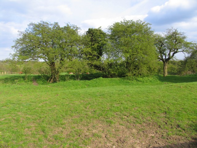
Brooke Covert, Rutland, also known as Wood or Forest, is a picturesque and serene area located in the county of Rutland, England. This beautiful woodland covers an extensive area of approximately 200 acres, encompassing a diverse range of flora and fauna.

The forest is predominantly composed of ancient oak trees, which provide a majestic canopy and create a magical atmosphere. Walking through Brooke Covert, visitors can immerse themselves in the tranquility of nature, listening to the melodious songs of birds and observing various wildlife species such as deer, foxes, and squirrels.

The woodland is crisscrossed by well-maintained footpaths, enabling visitors to explore the area and discover hidden gems along the way. There are also several picnic spots scattered throughout the forest, where visitors can relax and enjoy the peaceful surroundings.

Brooke Covert is not only a haven for nature enthusiasts but also a valuable ecological site. It supports a rich biodiversity and is home to numerous rare plants and animals. The forest management team works tirelessly to preserve and protect this natural habitat.

In addition to its natural beauty, Brooke Covert offers various recreational activities for visitors. There are designated areas for horse riding and cycling, providing opportunities for outdoor enthusiasts to enjoy different forms of exercise.

Overall, Brooke Covert, Rutland, is a captivating woodland that offers a tranquil escape from the hustle and bustle of everyday life. Its scenic beauty, diverse wildlife, and recreational activities make it a perfect destination for nature lovers and outdoor enthusiasts alike.

If you have any feedback on the listing, please let us know in the comments section below.

Brooke Covert Images

Images are sourced within 2km of 52.654532/-0.73697333 or Grid Reference SK8507. Thanks to Geograph Open Source API. All images are credited.

Oakham's 12th century Castle Hall
"Oakham Level Crossing" signal box
Ceremonial horseshoes in Castle Hall, Oakham Castle It is thought that this tradition is linked to the de Ferrers' family name; Ferrier was the Norman French word for farrier and the horseshoe has been a symbol of the de Ferrers family since Henry de Ferrers arrived in England in 1066.
Ceremonial horseshoes in Castle Hall, Oakham Castle
It is thought that this tradition is linked to the de Ferrers' family name; Ferrier was the Norman French word for farrier and the horseshoe has been a symbol of the de Ferrers family since Henry de Ferrers arrived in England in 1066.
Passer-by in Oakham Walking past the Rutland Toys and Dance Boutique - no longer in business.
Passer-by in Oakham
Walking past the Rutland Toys and Dance Boutique - no longer in business.
Birds on a roof Good example of Cold Overton Road dwellings
Birds on a roof
Good example of Cold Overton Road dwellings
Bridleway to Braunston Road
Bridleway to Gunthorpe
Bridleway to Gunthorpe According to OS the bridleway doesn't strictly keep to this concrete track but in practical terms it does.
Bridleway to Gunthorpe
According to OS the bridleway doesn't strictly keep to this concrete track but in practical terms it does.
Barn at Home Farm, Brooke
Rough grazing between Braunston and Brooke
Bridleway to Egleton
Bridleway to Egleton Follows the line of the hedge.
Bridleway to Egleton
Follows the line of the hedge.
Footpath towards Gunthorpe This footpath connects with a bridleway to Gunthorpe after a couple of fields. The footpath sign isn't quite pointing in the right direction but does point to where the footpath and bridleway join.
Footpath towards Gunthorpe
This footpath connects with a bridleway to Gunthorpe after a couple of fields. The footpath sign isn't quite pointing in the right direction but does point to where the footpath and bridleway join.
Junction of bridleways near Bridge Farm, Brooke
Bridleway from Gunthorpe near Brooke
Bridleway to Gunthorpe Well used by horses which makes it difficult for walkers when the ground is wet.
Bridleway to Gunthorpe
Well used by horses which makes it difficult for walkers when the ground is wet.
Electricity line crossing a bridleway near Brooke
Bridleway to Brooke The village of Brooke just visible in the trees in the centre of the picture.
Bridleway to Brooke
The village of Brooke just visible in the trees in the centre of the picture.
Show me another place!

Brooke Covert is located at Grid Ref: SK8507 (Lat: 52.654532, Lng: -0.73697333)

Unitary Authority: Rutland

Police Authority: Leicestershire

What 3 Words

///fetch.polka.footballers. Near Oakham, Rutland

Nearby Locations

Brooke Covert

Related Wikis

Oakham Urban District

Oakham was an Urban District in Rutland, England from 1911 to 1974. It was created under the Local Government Act 1894. Oakham Rural District had included...

Brooke Priory

Brooke Priory was a minor house of Augustinian monks in Brooke, Rutland. It was a cell of St Mary's Abbey, Kenilworth. == History == It was founded by...

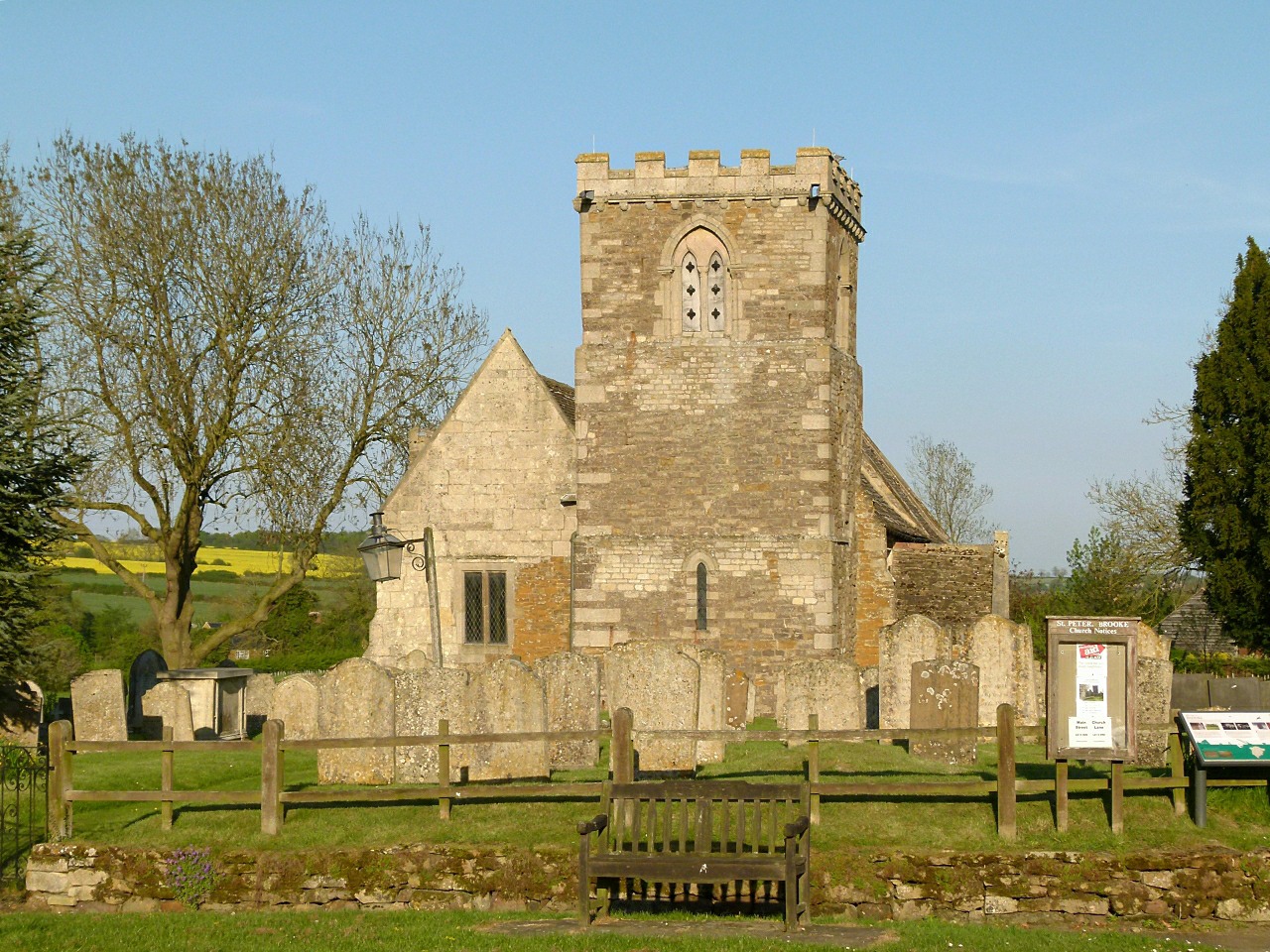
St Peter's Church, Brooke, Rutland

St Peter's Church is a Church of England parish church in Brooke, Rutland. It is a Grade I listed building. == History == The church has a carved doorway...

Oakham–Kettering line

The Oakham–Kettering line is a railway line in the East Midlands of England. Currently it has one passenger station in operation, at Corby. == Current... ==

Nearby Amenities

Located within 500m of 52.654532,-0.73697333
Power: tower
Source: OS OpenData Vector Map District
Lat/Long: 52.657184/-0.7331047
Power: tower
Source: OS OpenData Vector Map District
Lat/Long: 52.6555793/-0.7374776
Fixme: complicated junction of power lines here, see OS VMD
Power: tower
Source: OS OpenData Vector Map District
Lat/Long: 52.6547955/-0.74054
Power: tower
Source: OS OpenData Vector Map District
Lat/Long: 52.6527038/-0.7393279
Power: tower
Lat/Long: 52.6546892/-0.7401564
Power: tower
Lat/Long: 52.6547978/-0.740531
Power: tower
Lat/Long: 52.6550748/-0.7404132
Power: tower
Lat/Long: 52.655189/-0.7407489
Power: pole
Lat/Long: 52.6553459/-0.7422458
Power: pole
Lat/Long: 52.6558626/-0.7394409
Power: pole
Lat/Long: 52.6561696/-0.7379431
Power: pole
Lat/Long: 52.656566/-0.7370302
Power: pole
Lat/Long: 52.6571198/-0.7357969
Power: pole
Lat/Long: 52.6576674/-0.7346322
Power: pole
Lat/Long: 52.6581378/-0.7336685
Place: farm
Lat/Long: 52.6519042/-0.7424728
The data included in this document is from www.openstreetmap.org. The data is made available under ODbL.

Have you been to Brooke Covert?

Leave your review of Brooke Covert below (or comments, questions and feedback).