Hellbottom Wood

Wood, Forest in Buckinghamshire

England

Hellbottom Wood

Simulated rabbit shoot with clay pigeons at EJ Churchill Shooting Ground near High Wycombe, Bucks Here an ardent shooter tries his aim at these difficult variation of clay pigeons.
Simulated rabbit shoot with clay pigeons at EJ Churchill Shooting Ground near High Wycombe, Bucks Credit: Jeremy Bolwell

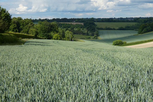
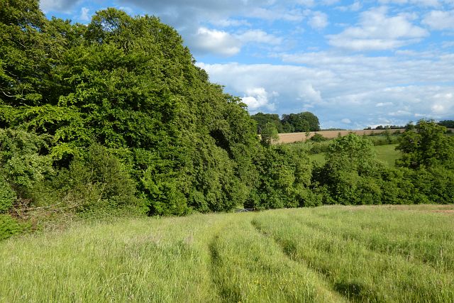
Hellbottom Wood is a picturesque woodland located in the county of Buckinghamshire, England. Covering an extensive area of approximately 100 acres, this ancient forest is nestled amidst the rolling Chiltern Hills, providing a serene and enchanting escape for nature lovers and outdoor enthusiasts alike.

The woodland boasts a diverse range of flora and fauna, with towering oak trees, beech trees, and hazel groves dominating the landscape. A rich carpet of bluebells blankets the forest floor during springtime, creating a breathtaking sight for visitors. The dense canopy of the trees provides a haven for a variety of bird species, including woodpeckers, owls, and thrushes, making it a haven for birdwatchers.

Hellbottom Wood is crisscrossed by a network of well-maintained trails, offering visitors the opportunity to explore its natural wonders. The paths wind through the forest, leading to hidden clearings and babbling brooks, adding to the sense of tranquility and seclusion. The wood also features a small pond, teeming with aquatic life, which serves as a watering hole for the local wildlife.

History and folklore surround Hellbottom Wood, adding to its allure. Local legends speak of mysterious happenings within the forest, with tales of ghostly apparitions and supernatural occurrences. The wood's name, Hellbottom, is said to derive from its dark reputation as a place of eerie and unsettling experiences.

Overall, Hellbottom Wood in Buckinghamshire is a captivating and idyllic woodland, offering a peaceful retreat for those seeking solace in nature. Its breathtaking beauty, diverse wildlife, and intriguing history make it a truly enchanting destination for visitors of all ages.

If you have any feedback on the listing, please let us know in the comments section below.

Hellbottom Wood Images

Images are sourced within 2km of 51.631576/-0.81154371 or Grid Reference SU8293. Thanks to Geograph Open Source API. All images are credited.

Simulated rabbit shoot with clay pigeons at EJ Churchill Shooting Ground near High Wycombe, Bucks Here an ardent shooter tries his aim at these difficult variation of clay pigeons.
Simulated rabbit shoot with clay pigeons at EJ Churchill Shooting Ground near High Wycombe, Bucks
Here an ardent shooter tries his aim at these difficult variation of clay pigeons.
West Wycombe : entrance, Hellfire Caves Deecription and background at <a href="https://www.geograph.org.uk/photo/3562974">SU8294 : Hellfire Caves, Church Lane, West Wycombe</a>.
West Wycombe : entrance, Hellfire Caves
West Wycombe Park View from the Dashwood Mausoleum.
West Wycombe Park
View from the Dashwood Mausoleum.
West Wycombe : St Paul's Church The church was built in 1875 to a design by architect John West Hugall.
West Wycombe : St Paul's Church
The church was built in 1875 to a design by architect John West Hugall.
The Dashwood Mausoleum
The Whites Beaconsfield Terrace in Adams Park Adams Park is the home of Wycombe Wanderers.
The Whites Beaconsfield Terrace in Adams Park
Adams Park is the home of Wycombe Wanderers.
The Frank Adams Stand at Adams Park Adams Park is the home of Wycombe Wanderers.
The Frank Adams Stand at Adams Park
Adams Park is the home of Wycombe Wanderers.
The Lords Stand at Adams Park
The Frank Adams Stand at Adams Park Adams Park is the home of Wycombe Wanderers.
The Frank Adams Stand at Adams Park
Adams Park is the home of Wycombe Wanderers.
The Whites Beaconsfield Terrace at Adams Park Adams Park is the home of Wycombe Wanderers.
The Whites Beaconsfield Terrace at Adams Park
Adams Park is the home of Wycombe Wanderers.
The Lords Stand at Adams Park Adams Park is the home of Wycombe Wanderers.
The Lords Stand at Adams Park
Adams Park is the home of Wycombe Wanderers.
Railway bridge over Cookshall Lane This bridge carries the Chiltern Main Line over Cookshall Lane in West Wycombe.  The abutments in the foreground carried the old Wycombe railway single track before the line was rebuilt and doubled in the early 1900's.
Railway bridge over Cookshall Lane
This bridge carries the Chiltern Main Line over Cookshall Lane in West Wycombe. The abutments in the foreground carried the old Wycombe railway single track before the line was rebuilt and doubled in the early 1900's.
Farmland, Lane End Fields of wheat in the valley descending from Fryers Farm.
Farmland, Lane End
Fields of wheat in the valley descending from Fryers Farm.
Farmland, High Wycombe A reinstated bridleway crossing a field of wheat to the east of Hellbottom Wood.
Farmland, High Wycombe
A reinstated bridleway crossing a field of wheat to the east of Hellbottom Wood.
Woods and farmland, Wheeler End A footpath descends at the western end of Great Wood.
Woods and farmland, Wheeler End
A footpath descends at the western end of Great Wood.
West Wycombe - Tudor House "A Fine English Butchers" on West Wycombe High Street which has a range of historic buildings and shops dating from the 16th century. This street was once the coaching road between London and Oxford.
<span class="nowrap"><a title="www.nationaltrust.org.uk" rel="nofollow ugc noopener" href="http://www.nationaltrust.org.uk">Link</a><img style="margin-left:2px;" alt="External link" title="External link - shift click to open in new window" src="https://s1.geograph.org.uk/img/external.png" width="10" height="10"/></span>
West Wycombe - Tudor House
"A Fine English Butchers" on West Wycombe High Street which has a range of historic buildings and shops dating from the 16th century. This street was once the coaching road between London and Oxford. LinkExternal link
West Wycombe - High Street West Wycombe High Street has a range of historic buildings and shops dating from the 16th century. This street was once the coaching road between London and Oxford.
<span class="nowrap"><a title="www.nationaltrust.org.uk" rel="nofollow ugc noopener" href="http://www.nationaltrust.org.uk">Link</a><img style="margin-left:2px;" alt="External link" title="External link - shift click to open in new window" src="https://s1.geograph.org.uk/img/external.png" width="10" height="10"/></span>
West Wycombe - High Street
West Wycombe High Street has a range of historic buildings and shops dating from the 16th century. This street was once the coaching road between London and Oxford. LinkExternal link
West Wycombe - Church Loft West Wycombe High Street has a range of historic buildings and shops dating from the 16th century. Church Loft is timber framed with later brick infill - and has been a jail.
This street was once the coaching road between London and Oxford.
<span class="nowrap"><a title="www.nationaltrust.org.uk" rel="nofollow ugc noopener" href="http://www.nationaltrust.org.uk">Link</a><img style="margin-left:2px;" alt="External link" title="External link - shift click to open in new window" src="https://s1.geograph.org.uk/img/external.png" width="10" height="10"/></span>
West Wycombe - Church Loft
West Wycombe High Street has a range of historic buildings and shops dating from the 16th century. Church Loft is timber framed with later brick infill - and has been a jail. This street was once the coaching road between London and Oxford. LinkExternal link
Show me another place!

Hellbottom Wood is located at Grid Ref: SU8293 (Lat: 51.631576, Lng: -0.81154371)

Unitary Authority: Buckinghamshire

Police Authority: Thames Valley

What 3 Words

///long.summer.humble. Near High Wycombe, Buckinghamshire

Related Wikis

Adams Park

Adams Park is an association football stadium in High Wycombe, Buckinghamshire, England. Built in 1990, it is the home ground of the local Wycombe Wanderers...

Wycombe District

Wycombe District was a local government district in Buckinghamshire in south-central England. Its council was based in the town of High Wycombe. The district...

West Wycombe Park

West Wycombe Park is a country house built between 1740 and 1800 near the village of West Wycombe in Buckinghamshire, England. It was conceived as a pleasure...

Piddington and Wheeler End

Piddington and Wheeler End is a small civil parish within Wycombe District Council, Buckinghamshire, England. Within the parish are the main hamlets of...

West Wycombe

West Wycombe is a small village famed for its manor houses and its hills. It is three miles west of High Wycombe, Buckinghamshire, England. The historic...

The Swan, West Wycombe

The Swan is a Grade II listed pub at High Street, West Wycombe, Buckinghamshire.It is on the Campaign for Real Ale's National Inventory of Historic Pub...

Lane End, Buckinghamshire

Lane End is a village and civil parish in Buckinghamshire, England. It is just south of the M40 from High Wycombe, about 2 miles (3.2 km) west of Booker...

Piddington, Buckinghamshire

Piddington is a hamlet in the parish of Piddington and Wheeler End in Buckinghamshire, England. It is located on the main A40 between Stokenchurch and...

Nearby Amenities

Located within 500m of 51.631576,-0.81154371
Power: pole
Lat/Long: 51.6273268/-0.8119261
Power: pole
Lat/Long: 51.6277081/-0.8132109
Power: pole
Lat/Long: 51.6281043/-0.8146566
Power: pole
Lat/Long: 51.6284756/-0.8159441
The data included in this document is from www.openstreetmap.org. The data is made available under ODbL.

Have you been to Hellbottom Wood?

Leave your review of Hellbottom Wood below (or comments, questions and feedback).