East Guldeford

Settlement in Sussex Rother

England

East Guldeford

Northpoint Beach Watersports Centre
Northpoint Beach Watersports Centre Credit: Andrew Curtis

East Guldeford is a small village located in the district of Rother, Sussex, England. Situated on the southern coast, it is part of the civil parish of Iden. The village is set amidst picturesque countryside, with rolling hills and meandering streams that contribute to its charm.

East Guldeford is home to a population of around 200 residents, living in a mix of historic and modern houses. The architecture in the village is predominantly traditional, with a few modern additions. The village is known for its tight-knit community and friendly atmosphere, which is evident in the various social activities organized for residents throughout the year.

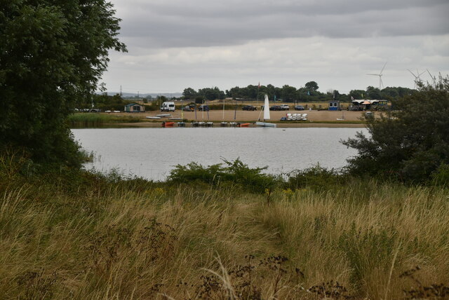
The village is surrounded by lush green fields and farmland, providing a peaceful and tranquil environment. It enjoys close proximity to the beautiful coastline, with Camber Sands, a renowned sandy beach, just a short distance away. This makes East Guldeford an attractive destination for nature enthusiasts and beachgoers alike.

Despite its small size, East Guldeford is not far from larger towns and amenities. The nearby town of Rye, with its medieval history and charming streets, offers a range of services including shops, restaurants, and schools. Additionally, the vibrant city of Brighton is within an hour's drive, providing access to a wider range of cultural and entertainment options.

Overall, East Guldeford is a beautiful and idyllic village nestled in the Sussex countryside, offering a peaceful and close-knit community with easy access to both stunning natural landscapes and nearby towns.

If you have any feedback on the listing, please let us know in the comments section below.

East Guldeford Images

Images are sourced within 2km of 50.960817/0.754528 or Grid Reference TQ9321. Thanks to Geograph Open Source API. All images are credited.

Northpoint Beach Watersports Centre
Island in flooded gravel pit
Creek, River Rother The River Rother runs for 35 miles from Rotherfield, East Sussex, entering Kent after Bodiam where it follows the county border to Wittersham, where it rejoins East Sussex to the mouth at Rye.

There are two other River Rothers in Yorkshire and in Hampshire to West Sussex.
Creek, River Rother
The River Rother runs for 35 miles from Rotherfield, East Sussex, entering Kent after Bodiam where it follows the county border to Wittersham, where it rejoins East Sussex to the mouth at Rye. There are two other River Rothers in Yorkshire and in Hampshire to West Sussex.
Creek and marsh
Creek and marsh
Small lake
Small lake
Flooded gravel pit
Flooded gravel pit
Boats moored on the River Rother The River Rother runs for 35 miles from Rotherfield, East Sussex, entering Kent after Bodiam where it follows the county border to Wittersham, where it rejoins East Sussex to the mouth at Rye.

There are two other River Rothers in Yorkshire and in Hampshire to West Sussex.
Boats moored on the River Rother
The River Rother runs for 35 miles from Rotherfield, East Sussex, entering Kent after Bodiam where it follows the county border to Wittersham, where it rejoins East Sussex to the mouth at Rye. There are two other River Rothers in Yorkshire and in Hampshire to West Sussex.
River Rother The River Rother runs for 35 miles from Rotherfield, East Sussex, entering Kent after Bodiam where it follows the county border to Wittersham, where it rejoins East Sussex to the mouth at Rye.

There are two other River Rothers in Yorkshire and in Hampshire to West Sussex.
River Rother
The River Rother runs for 35 miles from Rotherfield, East Sussex, entering Kent after Bodiam where it follows the county border to Wittersham, where it rejoins East Sussex to the mouth at Rye. There are two other River Rothers in Yorkshire and in Hampshire to West Sussex.
Footpath by River Rother
Field between Harbour Road and River Brede at Rye St Mary's church and the Ypres Tower are two of Rye's landmarks which are visible in the background..
Field between Harbour Road and River Brede at Rye
St Mary's church and the Ypres Tower are two of Rye's landmarks which are visible in the background..
Solvent recovery works, Rye Harbour Photographed from Gun Garden, Rye. An unexpected sight in this pretty corner.
Solvent recovery works, Rye Harbour
Photographed from Gun Garden, Rye. An unexpected sight in this pretty corner.
Old Gravel pit by Camber Rd
Flooded Gravel pit by Camber Rd
Sheep grazing by a flooded gravel pit
Flooded pit, Camber Rd
Sheep grazing by Camber Rd The area around here is low grade farmland, not suitable for much more than grazing sheep.
Sheep grazing by Camber Rd
The area around here is low grade farmland, not suitable for much more than grazing sheep.
Sheep grazing by Camber Rd
Show me another place!

East Guldeford is located at Grid Ref: TQ9321 (Lat: 50.960817, Lng: 0.754528)

Administrative County: East Sussex

District: Rother

Police Authority: Sussex

What 3 Words

///importers.blankets.revisit. Near Rye, East Sussex

Related Wikis

East Guldeford

East Guldeford is a village and civil parish in the Rother district of East Sussex, England. The village is located one mile (1.6 km) east of Rye on the...

Houghton Green Cliff

Houghton Green Cliff is a 0.14-hectare (0.35-acre) geological Site of Special Scientific Interest north of Rye in East Sussex, United Kingdom. It is a...

Rye railway station (Rye and Camber Tramway)

Rye railway station was a terminal station on the Rye and Camber Tramway in East Sussex, connecting Rye to Camber. Although the station was close to the...
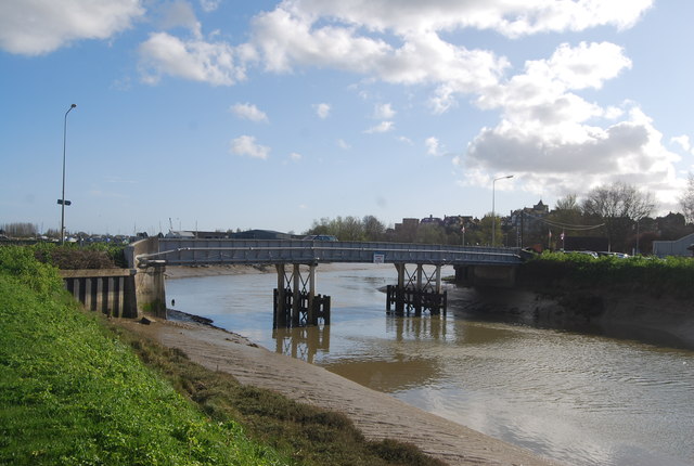
Monk Bretton Bridge

The Monk Bretton Bridge is a road bridge over the River Rother in Rye, East Sussex. It carries the A259 road, a major road between Folkestone and Hastings...

Playden

Playden is a village and civil parish in the Rother district of East Sussex, England. The village is located one mile (1.6 km) north-west of Rye. ��2...

Rye Studio School

Rye Studio School was a mixed studio school located in Rye, East Sussex, England. It opened in 2013 and catered for students aged 14–19 years. It was located...

Rye College

Rye College, formerly known as Thomas Peacocke Community College, is a coeducational secondary school with academy status, located in Rye, East Sussex...

Rye Austin Friary

Rye Austin Friary was an Augustinian friary in Conduit Street, Rye, East Sussex, England. Founded at an earlier site on the East cliff in 1364, the community...

Nearby Amenities

Located within 500m of 50.960817,0.754528
Created By: PaulY
Lat/Long: 50.9607015/0.7546642
Created By: PaulY
Lat/Long: 50.964771/0.7557779
East Guldeford
Crossing Activation: automatic
Crossing Barrier: half
Crossing Bell: yes
Crossing Light: yes
Description: Automatic Half Barrier Crossing (AHBC)
Railway: level_crossing
Lat/Long: 50.9618976/0.7538623
East Guldeford
Place: village
Source: npe
Lat/Long: 50.9588134/0.755803
Give Way
Direction: backward
Lat/Long: 50.9585492/0.7551569
Cafe
Beryl's Cafe
Addr Postcode: TN31 7PA
Fhrs Id: 766076
Lat/Long: 50.9594843/0.7548165
Salts Farm Shop
Addr Postcode: TN31 7PA
Addr Street: Folkestone Road
Fhrs Id: 766003
Shop: convenience
Lat/Long: 50.9591126/0.754602
Power: pole
Lat/Long: 50.9639487/0.7499789
Power: pole
Lat/Long: 50.9634786/0.75116
Power: pole
Lat/Long: 50.9629871/0.7523992
Power: pole
Lat/Long: 50.962397/0.7538684
Power: pole
Lat/Long: 50.9621464/0.7544814
Power: pole
Lat/Long: 50.9616712/0.7561408
Power: pole
Lat/Long: 50.9611614/0.7579014
Power: pole
Lat/Long: 50.9606666/0.7595647
Power: pole
Lat/Long: 50.9602849/0.7608519
Railway: level_crossing
Lat/Long: 50.9648876/0.7574563
Railway: level_crossing
Lat/Long: 50.9593027/0.7495937
Traffic Calming: island
Lat/Long: 50.958539/0.755207
The data included in this document is from www.openstreetmap.org. The data is made available under ODbL.

Have you been to East Guldeford?

Leave your review of East Guldeford below (or comments, questions and feedback).