Guy's Thorns

Wood, Forest in Buckinghamshire

England

Guy's Thorns

Direction Sign – Signpost opposite Church Lane, Oving Located on the east side of the junction of Church Lane, Baulk Road and Bowling Alley in Oving parish. 3 arms, 1 missing, and annulus finial. See also <a title="https://www.geograph.org.uk/photo/6044672" href="https://www.geograph.org.uk/photo/6044672">Link</a> and <span class="nowrap"><a title="http://www.flickr.com/photos/13171205@N08/3984808019" rel="nofollow ugc noopener" href="http://www.flickr.com/photos/13171205@N08/3984808019">Link</a><img style="margin-left:2px;" alt="External link" title="External link - shift click to open in new window" src="https://s1.geograph.org.uk/img/external.png" width="10" height="10"/></span>.

Milestone Society National ID: BU_SP7821
Direction Sign – Signpost opposite Church Lane, Oving Credit: M Hatton

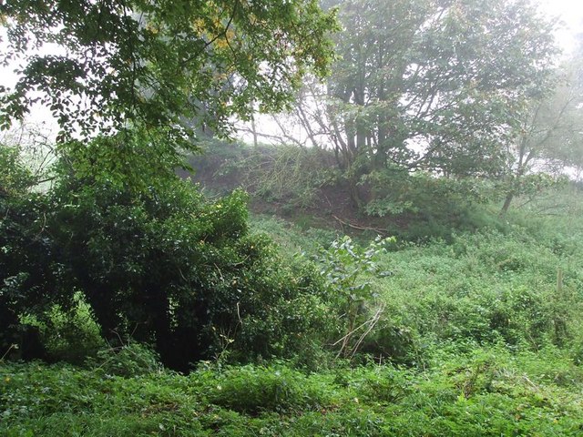
Guy's Thorns is a picturesque woodland located in Buckinghamshire, England. It is situated in the heart of the Chiltern Hills, an Area of Outstanding Natural Beauty. This ancient forest covers an area of approximately 120 acres and is renowned for its diverse wildlife and tranquil atmosphere.

The woodland is predominantly composed of native tree species such as oak, beech, and ash, which provide a dense canopy, creating a shaded and cool environment. The forest floor is rich in flora, with carpets of bluebells, wild garlic, and wood anemones adorning the forest during springtime.

Guy's Thorns is a haven for wildlife enthusiasts, offering a habitat for various species of birds, mammals, and insects. Birdwatchers can spot a range of species, including woodpeckers, nuthatches, and tawny owls. The forest is also home to deer and foxes, which can occasionally be seen roaming through the undergrowth.

The woodland is a popular destination for nature walks, with well-maintained trails winding through the forest, providing visitors with the opportunity to explore its beauty at their own pace. These paths are also suitable for cyclists and horse riders, ensuring accessibility for all.

Despite its natural beauty, Guy's Thorns is not equipped with any visitor facilities, such as toilets or cafes. However, its remote location and lack of amenities contribute to its peaceful and unspoiled charm.

Overall, Guy's Thorns is a hidden gem in Buckinghamshire, offering nature lovers a chance to immerse themselves in the serene beauty of a traditional English woodland.

If you have any feedback on the listing, please let us know in the comments section below.

Guy's Thorns Images

Images are sourced within 2km of 51.899967/-0.85546254 or Grid Reference SP7822. Thanks to Geograph Open Source API. All images are credited.

Direction Sign – Signpost opposite Church Lane, Oving Located on the east side of the junction of Church Lane, Baulk Road and Bowling Alley in Oving parish. 3 arms, 1 missing, and annulus finial. See also <a title="https://www.geograph.org.uk/photo/6044672" href="https://www.geograph.org.uk/photo/6044672">Link</a> and <span class="nowrap"><a title="http://www.flickr.com/photos/13171205@N08/3984808019" rel="nofollow ugc noopener" href="http://www.flickr.com/photos/13171205@N08/3984808019">Link</a><img style="margin-left:2px;" alt="External link" title="External link - shift click to open in new window" src="https://s1.geograph.org.uk/img/external.png" width="10" height="10"/></span>.

Milestone Society National ID: BU_SP7821
Direction Sign – Signpost opposite Church Lane, Oving
Located on the east side of the junction of Church Lane, Baulk Road and Bowling Alley in Oving parish. 3 arms, 1 missing, and annulus finial. See also Link and LinkExternal link. Milestone Society National ID: BU_SP7821
The A413 north of Whitchurch
Whitchurch Road, Hurdlesgrove Here is an earlier view <a title="https://www.geograph.org.uk/photo/5684048" href="https://www.geograph.org.uk/photo/5684048">Link</a>
Whitchurch Road, Hurdlesgrove
Here is an earlier view Link
Holy Well, Scorne Lane, North Marston This edifice marks the site of a well that was supplied by a spring whose waters were claimed to have curative properties. The spring was discovered in 1290 by the then rector of North Marston, Sir John Scorne and until the Reformation the site was a place of pilgrimage. Following a drowning in 1861, the well fell into disuse and was covered over, and by 1900 had been replaced with a pump. The renovations carried out in 2004-5 included the construction of the present shelter.
Holy Well, Scorne Lane, North Marston
This edifice marks the site of a well that was supplied by a spring whose waters were claimed to have curative properties. The spring was discovered in 1290 by the then rector of North Marston, Sir John Scorne and until the Reformation the site was a place of pilgrimage. Following a drowning in 1861, the well fell into disuse and was covered over, and by 1900 had been replaced with a pump. The renovations carried out in 2004-5 included the construction of the present shelter.
Cottages at north end of High Street, North Marston
Oving - All Saints Church All Saints, Oving dates from the C13th and is EH Grade II* listed <span class="nowrap"><a title="https://historicengland.org.uk/listing/the-list/list-entry/1117846?section=official-list-entry" rel="nofollow ugc noopener" href="https://historicengland.org.uk/listing/the-list/list-entry/1117846?section=official-list-entry">Link</a><img style="margin-left:2px;" alt="External link" title="External link - shift click to open in new window" src="https://s1.geograph.org.uk/img/external.png" width="10" height="10"/></span>
Oving - All Saints Church
All Saints, Oving dates from the C13th and is EH Grade II* listed LinkExternal link
Oving - The 'Black Boy' public house The 'Black Boy' is the only pub in the village of Oving, though there used to be two or possibly three others, all long closed - see information at foot of this description.
It is somewhat larger inside than this external view would suggest and it has a large garden at the rear (see <a href="https://www.geograph.org.uk/photo/7450312">SP7821 : Oving - Garden of the 'Black Boy' pub</a>).
It is EH Grade II listed: <span class="nowrap"><a title="https://historicengland.org.uk/listing/the-list/list-entry/1319260?section=official-list-entry" rel="nofollow ugc noopener" href="https://historicengland.org.uk/listing/the-list/list-entry/1319260?section=official-list-entry">Link</a><img style="margin-left:2px;" alt="External link" title="External link - shift click to open in new window" src="https://s1.geograph.org.uk/img/external.png" width="10" height="10"/></span>
Good food and ale, see their own website here: <span class="nowrap"><a title="https://www.theblackboyoving.co.uk" rel="nofollow ugc noopener" href="https://www.theblackboyoving.co.uk">Link</a><img style="margin-left:2px;" alt="External link" title="External link - shift click to open in new window" src="https://s1.geograph.org.uk/img/external.png" width="10" height="10"/></span>

Former pubs of Oving
The Butchers Arms - closed after 1966 - see <span class="nowrap"><a title="https://pubshistory.com/Buckinghamshire/Oving/ButchersArms.shtml" rel="nofollow ugc noopener" href="https://pubshistory.com/Buckinghamshire/Oving/ButchersArms.shtml">Link</a><img style="margin-left:2px;" alt="External link" title="External link - shift click to open in new window" src="https://s1.geograph.org.uk/img/external.png" width="10" height="10"/></span> and <span class="nowrap"><a title="https://www.francisfrith.com/uk/oving/the-butchers-arms-oving_memory-220501" rel="nofollow ugc noopener" href="https://www.francisfrith.com/uk/oving/the-butchers-arms-oving_memory-220501">Link</a><img style="margin-left:2px;" alt="External link" title="External link - shift click to open in new window" src="https://s1.geograph.org.uk/img/external.png" width="10" height="10"/></span>
The Crown Inn - closed after 1871 - see <span class="nowrap"><a title="https://pubshistory.com/Buckinghamshire/Oving/CrownInn.shtml" rel="nofollow ugc noopener" href="https://pubshistory.com/Buckinghamshire/Oving/CrownInn.shtml">Link</a><img style="margin-left:2px;" alt="External link" title="External link - shift click to open in new window" src="https://s1.geograph.org.uk/img/external.png" width="10" height="10"/></span>
The Beer House - may have been a beer wholesaler rather than a pub, the only information about this establishment is from the 1871 census - see <span class="nowrap"><a title="https://pubshistory.com/Buckinghamshire/Oving/BowlingAlley.shtml" rel="nofollow ugc noopener" href="https://pubshistory.com/Buckinghamshire/Oving/BowlingAlley.shtml">Link</a><img style="margin-left:2px;" alt="External link" title="External link - shift click to open in new window" src="https://s1.geograph.org.uk/img/external.png" width="10" height="10"/></span>
Oving - The 'Black Boy' public house
The 'Black Boy' is the only pub in the village of Oving, though there used to be two or possibly three others, all long closed - see information at foot of this description. It is somewhat larger inside than this external view would suggest and it has a large garden at the rear (see SP7821 : Oving - Garden of the 'Black Boy' pub). It is EH Grade II listed: LinkExternal link Good food and ale, see their own website here: LinkExternal link Former pubs of Oving The Butchers Arms - closed after 1966 - see LinkExternal link and LinkExternal link The Crown Inn - closed after 1871 - see LinkExternal link The Beer House - may have been a beer wholesaler rather than a pub, the only information about this establishment is from the 1871 census - see LinkExternal link
Oving - Garden of the 'Black Boy' pub Large garden at the rear of <a href="https://www.geograph.org.uk/photo/7450310">SP7821 : Oving - The 'Black Boy' public house</a>.
There are excellent views to North Marston and Granborough from here - see <a href="https://www.geograph.org.uk/photo/7450313">SP7722 : View to North Marston from Oving</a>
Oving - Garden of the 'Black Boy' pub
Large garden at the rear of SP7821 : Oving - The 'Black Boy' public house. There are excellent views to North Marston and Granborough from here - see SP7722 : View to North Marston from Oving
View to North Marston from Oving Looking over rolling Buckinghamshire countryside to the village of North Marston from <a href="https://www.geograph.org.uk/photo/7450312">SP7821 : Oving - Garden of the 'Black Boy' pub</a> in Oving.
View to North Marston from Oving
Looking over rolling Buckinghamshire countryside to the village of North Marston from SP7821 : Oving - Garden of the 'Black Boy' pub in Oving.
St Mary, North Marston - south-east elevation
St Mary, North Marston - south elevation looking west
St Mary, North Marston - north elevation looking east
St Mary, North Marston - west tower
Track to Maynes Hill Farm, Hoggeston
Oving village Looking towards the centre of the village . The church is hidden, but can just be made out behind the trunk of the lone, bare tree.
Oving village
Looking towards the centre of the village . The church is hidden, but can just be made out behind the trunk of the lone, bare tree.
View from the lane to Creslow Creslow is a hamlet at the end of a cul-de-sac lane. This view is from that lane a little way after it has left the A413. Near the far right of the image can just be seen a little brick hut which is at SP803220. That's about the most noteworthy feature of this square !!!
View from the lane to Creslow
Creslow is a hamlet at the end of a cul-de-sac lane. This view is from that lane a little way after it has left the A413. Near the far right of the image can just be seen a little brick hut which is at SP803220. That's about the most noteworthy feature of this square !!!
Farm buildings, Hurdlesgrove Farm A pigsty which is coming apart at one end.
Farm buildings, Hurdlesgrove Farm
A pigsty which is coming apart at one end.
Farmyard, Hurdlesgrove Farm A farmyard dominated by a very large heap of manure, so high that it blots out the view beyond apart from a couple of treetops.  It would not have looked any more appealing even on a less wet day.
Farmyard, Hurdlesgrove Farm
A farmyard dominated by a very large heap of manure, so high that it blots out the view beyond apart from a couple of treetops. It would not have looked any more appealing even on a less wet day.
Show me another place!

Guy's Thorns is located at Grid Ref: SP7822 (Lat: 51.899967, Lng: -0.85546254)

Unitary Authority: Buckinghamshire

Police Authority: Thames Valley

What 3 Words

///charmingly.activism.sapping. Near Winslow, Buckinghamshire

Nearby Locations

Oving Guy's Thorns

Related Wikis

North Marston

North Marston is a village and also a civil parish in the Buckinghamshire district in the ceremonial county of Buckinghamshire, England. It is located...

Oving, Buckinghamshire

Oving (historically , more recently ) is a village and also a civil parish within Aylesbury Vale district in Buckinghamshire, England. It is located about...

Bolbec Castle

Bolbec Castle or Bolebec Castle, was a castle in the village of Whitchurch, Buckinghamshire, England. == History == The motte and bailey castle was illegally...

Creslow

Creslow (occasionally also known as Christlow) is a village and civil parish within Aylesbury Vale district in Buckinghamshire, England. It is close to...

Granborough

Granborough (previously Grandborough) is a village and civil parish in Buckinghamshire, England. It is around 5 miles (8 km) north of Waddesdon and 7 miles...

Pitchcott

Pitchcott is a village and civil parish in the Aylesbury Vale district of Buckinghamshire, England. It is about 3 miles (5 km) north-east of Waddesdon...

Hoggeston

Hoggeston is a village and civil parish within the Aylesbury Vale district in Buckinghamshire, England. It is located around 2+1⁄2 miles (4 km) south-east...

Creslow Park

Creslow Park is a large specialist technical facility located in Creslow, in the Aylesbury Vale in the English county of Buckinghamshire. It was originally...

Have you been to Guy's Thorns?

Leave your review of Guy's Thorns below (or comments, questions and feedback).