Ash Plantation

Wood, Forest in Hampshire East Hampshire

England

Ash Plantation

Oast House Twin square kiln oast house.
Oast House Credit: Oast House Archive

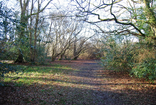
Ash Plantation is a picturesque woodland located in Hampshire, England. Spanning over a vast area of approximately 100 acres, it is a popular destination for nature enthusiasts and outdoor lovers. The forest is primarily composed of a variety of ash trees, hence its name, which provide a dense and serene canopy over the woodland floor.

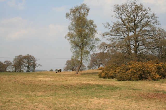
The plantation is renowned for its rich biodiversity, housing an abundance of flora and fauna. It is home to numerous species of birds, including woodpeckers, owls, and various songbirds, making it an ideal spot for birdwatching. The forest floor is also adorned with a colorful array of wildflowers, such as bluebells and primroses, which bloom during the spring season, creating a vibrant and enchanting atmosphere.

The tranquility of Ash Plantation makes it a perfect place for leisurely walks and peaceful picnics. There are well-maintained trails that wind through the forest, offering visitors the opportunity to explore and immerse themselves in the natural beauty of the surroundings. Additionally, the plantation provides facilities such as picnic areas, benches, and information boards to enhance the visitor experience.

Ash Plantation is not only a haven for nature enthusiasts but also serves as an important ecological site. It plays a vital role in maintaining the local ecosystem by providing habitat and shelter for various wildlife species. The forest also contributes to the overall conservation efforts in the region, preserving the natural heritage of Hampshire.

Overall, Ash Plantation in Hampshire is a captivating woodland that offers a peaceful retreat and a chance to connect with nature in a serene and picturesque setting.

If you have any feedback on the listing, please let us know in the comments section below.

Ash Plantation Images

Images are sourced within 2km of 51.131854/-0.91941293 or Grid Reference SU7537. Thanks to Geograph Open Source API. All images are credited.

Oast House Twin square kiln oast house.
Oast House
Twin square kiln oast house.
Farmland, Binsted
Farmland, Binsted
Grassland, Binsted
Grassland, Binsted
Farmland, Binsted
Farmland, Binsted
Track and grassland, Kingsley
Pasture, Worldham
Pasture, Worldham
Farmland, Worldham
Farmland, Worldham
Pasture, Worldham
Pasture, Worldham
Farmland and cottages, Worldham
Farmland, Worldham
Farmland, Worldham
Shortheath Common Looking across Shortheath Common pond standing close by to the car park area.
Shortheath Common
Looking across Shortheath Common pond standing close by to the car park area.
Oakhanger village hall Photo of Oakhanger village hall taken from standing on the green that sits in front of it.
Oakhanger village hall
Photo of Oakhanger village hall taken from standing on the green that sits in front of it.
St Mary Magdalene's Church in Oakhanger The front view of St Mary Magdalene's Church in Oakhanger.
St Mary Magdalene's Church in Oakhanger
The front view of St Mary Magdalene's Church in Oakhanger.
Lane to Hartley Mauditt The sign is some way from any village, it seems to be at the start of the Hartley Mauditt estate, or at least its woodlands. The two posts may be an indication of this.
Lane to Hartley Mauditt
The sign is some way from any village, it seems to be at the start of the Hartley Mauditt estate, or at least its woodlands. The two posts may be an indication of this.
Shortheath Pond Part of the Shortheath Common nature reserve.
Shortheath Pond
Part of the Shortheath Common nature reserve.
Hilltop junction The third way, down the hill with a falling rock hazard, is signed to Oakhanger and Blackmoor.
Hilltop junction
The third way, down the hill with a falling rock hazard, is signed to Oakhanger and Blackmoor.
Lane to Hartley Maunditt Pedestrians need not hazard this narrow defile (not there is much traffic), there is a path along the field edge up to the right.
Lane to Hartley Maunditt
Pedestrians need not hazard this narrow defile (not there is much traffic), there is a path along the field edge up to the right.
Hartley Maunditt church St. Leonard's is the only building of the village proper left, a field to the north is mapped as site of the old village, but nothing obvious is to be seen.
Hartley Maunditt church
St. Leonard's is the only building of the village proper left, a field to the north is mapped as site of the old village, but nothing obvious is to be seen.
Show me another place!

Ash Plantation is located at Grid Ref: SU7537 (Lat: 51.131854, Lng: -0.91941293)

Administrative County: Hampshire

District: East Hampshire

Police Authority: Hampshire

What 3 Words

///cookery.pastime.litigate. Near Alton, Hampshire

Related Wikis

Nearby Amenities

Located within 500m of 51.131854,-0.91941293
Barrier: kissing_gate
Lat/Long: 51.130644/-0.9204931
Barrier: kissing_gate
Lat/Long: 51.133585/-0.9249165
Barrier: kissing_gate
Lat/Long: 51.1285467/-0.9175634
Barrier: kissing_gate
Lat/Long: 51.1324278/-0.9219667
Power: tower
Ref: PKF9
Lat/Long: 51.1289725/-0.9240979
Power: tower
Ref: PKF10
Lat/Long: 51.1293603/-0.9204611
Power: tower
Ref: PKF11
Lat/Long: 51.1297833/-0.9166908
King John's Hill
Ele: 129
Natural: peak
Lat/Long: 51.1336136/-0.9210588
The data included in this document is from www.openstreetmap.org. The data is made available under ODbL.

Have you been to Ash Plantation?

Leave your review of Ash Plantation below (or comments, questions and feedback).