Clawson Thorns

Wood, Forest in Leicestershire Melton

England

Clawson Thorns

Grass field off Clawson Lane A hazy Vale of Belvour beyond.
Grass field off Clawson Lane Credit: Jonathan Thacker

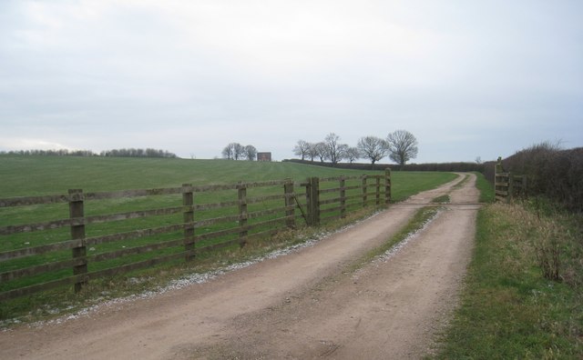
Clawson Thorns is a small woodland area located in Leicestershire, England. Situated near the villages of Waltham on the Wolds and Ab Kettleby, this forested patch covers approximately 50 acres of land. Known for its picturesque scenery and tranquil atmosphere, Clawson Thorns offers a serene escape from the hustle and bustle of everyday life.

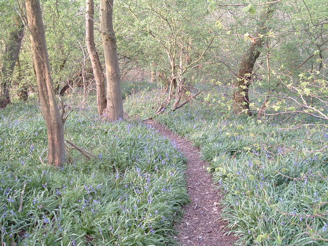
The woodland is predominantly composed of native tree species, including oak, ash, birch, and beech. These towering trees provide shelter and a habitat for a diverse range of wildlife, making it a popular spot for nature enthusiasts and bird watchers. Visitors to Clawson Thorns can expect to encounter various species such as woodpeckers, owls, and squirrels during their exploration of the area.

The forest is crisscrossed with a network of well-maintained footpaths, allowing visitors to easily navigate through the woods. These paths wind their way through the trees, providing glimpses of sunlight filtering through the dense foliage and creating a magical ambiance.

Clawson Thorns also boasts a rich history, with evidence of human habitation dating back to prehistoric times. Archaeological excavations have unearthed artifacts and ancient burial sites, revealing the presence of early settlers in the area.

For those seeking a peaceful retreat in nature, Clawson Thorns offers an idyllic setting. Its tranquil woodland, diverse wildlife, and historical significance make it a hidden gem in Leicestershire's countryside.

If you have any feedback on the listing, please let us know in the comments section below.

Clawson Thorns Images

Images are sourced within 2km of 52.823374/-0.91788957 or Grid Reference SK7325. Thanks to Geograph Open Source API. All images are credited.

Grass field off Clawson Lane A hazy Vale of Belvour beyond.
Grass field off Clawson Lane
A hazy Vale of Belvour beyond.
Mill Farm seen from Sandpit Lane, Long Clawson Mill Farm is in the centre of the picture.
Mill Farm seen from Sandpit Lane, Long Clawson
Mill Farm is in the centre of the picture.
Sand Pit Lane, Long Clawson
Grass field and horses, Long Clawson
Footpath and houses, Long Clawson
Clawson Lane
Clawson Lane
A green lane north of Ironstone Lane The probable route of 'le ferdgate' continuing as a public access route across the Leicestershire Wolds
A green lane north of Ironstone Lane
The probable route of 'le ferdgate' continuing as a public access route across the Leicestershire Wolds
A green lane north of Ironstone Lane The probable route of 'le ferdgate' continuing as a public access route and the parish boundary across the Leicestershire Wolds
A green lane north of Ironstone Lane
The probable route of 'le ferdgate' continuing as a public access route and the parish boundary across the Leicestershire Wolds
A crossing of salt ways The green lane following the route of 'le ferdgate' (used as a saltway <span class="nowrap"><a title="https://epns.nottingham.ac.uk/browse/id/53285cd4b47fc40adf00110f-Framland+Hundred" rel="nofollow ugc noopener" href="https://epns.nottingham.ac.uk/browse/id/53285cd4b47fc40adf00110f-Framland+Hundred">Link</a><img style="margin-left:2px;" alt="External link" title="External link - shift click to open in new window" src="https://s1.geograph.org.uk/img/external.png" width="10" height="10"/></span> ) crossing Langdyke Lane, the route of the Roman road Margary 58a (aka the Salt Way).
A crossing of salt ways
The green lane following the route of 'le ferdgate' (used as a saltway LinkExternal link ) crossing Langdyke Lane, the route of the Roman road Margary 58a (aka the Salt Way).
'le ferdgate' crossing Langdyke Lane A crossing of two ancient (pre-Roman origins?) roads: 'le ferdgate' and the Salt Way
'le ferdgate' crossing Langdyke Lane
A crossing of two ancient (pre-Roman origins?) roads: 'le ferdgate' and the Salt Way
Public access route crossing a tributary to Scalford Brook Double hedges and the parish boundary continuing the route of 'le ferdgate' across the Leicestershire Wolds
Public access route crossing a tributary to Scalford Brook
Double hedges and the parish boundary continuing the route of 'le ferdgate' across the Leicestershire Wolds
An ancient route much abused The route of 'le ferdgate' rendered almost impassable by modern 4WDs and motorbikes
An ancient route much abused
The route of 'le ferdgate' rendered almost impassable by modern 4WDs and motorbikes
Public access route across the Leicestershire Wolds The route of 'le ferdgate' approaching the top of the Belvoir escarpment
Public access route across the Leicestershire Wolds
The route of 'le ferdgate' approaching the top of the Belvoir escarpment
Crossing Clawson Lane at the top of the Belvoir escarpment The route of 'le ferdgate' about to drop down Brock Hill
Crossing Clawson Lane at the top of the Belvoir escarpment
The route of 'le ferdgate' about to drop down Brock Hill
Brock Hill down to the Vale of Belvoir The route of  'le ferdgate' into the Vale of Belvoir.
The village of Harby, where " ...  Walter son of Roger de Herdebi  [granted] land and meadow in Herdebi ... part abutting 'in le Ferdgate' ... " <span class="nowrap"><a title="https://www.british-history.ac.uk/ancient-deeds/vol3/pp387-399" rel="nofollow ugc noopener" href="https://www.british-history.ac.uk/ancient-deeds/vol3/pp387-399">Link</a><img style="margin-left:2px;" alt="External link" title="External link - shift click to open in new window" src="https://s1.geograph.org.uk/img/external.png" width="10" height="10"/></span> lies in the vale about 3 miles ahead.
Brock Hill down to the Vale of Belvoir
The route of 'le ferdgate' into the Vale of Belvoir. The village of Harby, where " ... Walter son of Roger de Herdebi [granted] land and meadow in Herdebi ... part abutting 'in le Ferdgate' ... " LinkExternal link lies in the vale about 3 miles ahead.
Core sample by old railway line This core sample has been discarded next to the deep cutting carrying the former Midland Railway line between Holwell and Wycomb Junction. Perhaps someone is thinking of resuming ironstone quarrying in this area?
Core sample by old railway line
This core sample has been discarded next to the deep cutting carrying the former Midland Railway line between Holwell and Wycomb Junction. Perhaps someone is thinking of resuming ironstone quarrying in this area?
The Old Manor House, Long Clawson Shows a contrast between the ironstone used in the construction of the building and the freestone used for window surrounds.
The Old Manor House, Long Clawson
Shows a contrast between the ironstone used in the construction of the building and the freestone used for window surrounds.
The track to Clawson Hill Farm Looks isolated and bleak on a cold February afternoon.
The track to Clawson Hill Farm
Looks isolated and bleak on a cold February afternoon.
Show me another place!

Clawson Thorns is located at Grid Ref: SK7325 (Lat: 52.823374, Lng: -0.91788957)

Administrative County: Leicestershire

District: Melton

Police Authority: Leicestershire

What 3 Words

///toasted.myself.hospitals. Near Long Clawson, Leicestershire

Nearby Locations

Clawson Thorns

Related Wikis

Holwell Mouth

Holwell Mouth is a 14.5-hectare (36-acre) biological Site of Special Scientific Interest south-east of Nether Broughton in Leicestershire. It is common...

Long Clawson

Long Clawson is a village and former civil parish, now included in that of Clawson, Hose and Harby, in the Melton district and the county of Leicestershire...

Long Clawson and Hose railway station

Long Clawson and Hose railway station was a railway station serving the villages of Long Clawson and Hose, Leicestershire on the Great Northern and London...

Holwell Reserves

Holwell Reserves is a 16.4 hectares (41 acres) nature reserve north of Melton Mowbray in Leicestershire. It is owned and managed by the Leicestershire...

Ab Kettleby Manor

Ab Kettleby Manor is an early 17th-century house in the village of Ab Kettleby, Leicestershire. Built of ironstone with a central brick chimney the house...

Ab Kettleby

Ab Kettleby is a village and civil parish in the Melton district of Leicestershire, England, located 3 miles (4.8 km) north of Melton Mowbray, on the A606...

St James' Church, Ab Kettleby

St James’ Church, Ab Kettleby is a Grade II* listed parish church in the Church of England in Ab Kettleby, Leicestershire. == History == The church dates...

Melton Rural District

Melton was a rural district in Leicestershire, England from 1894 to 1935. It was created in 1894 under the Local Government Act 1894 as a successor to...

Nearby Amenities

Located within 500m of 52.823374,-0.91788957
LONGCLAWSONA5
Man Made: petroleum_well
Source: DECC
Lat/Long: 52.8240589/-0.9200778
LONGCLAWSON2
Disused: yes
Man Made: petroleum_well
Ref GB Decc: LO/06-4
Source: DECC
Lat/Long: 52.82325/-0.9246667
LONGCLAWSONA4
Disused: yes
Man Made: petroleum_well
Ref GB Decc: LO/06-A4
Source: DECC
Lat/Long: 52.82325/-0.9168889
LONGCLAWSONC1
Disused: yes
Man Made: petroleum_well
Ref GB Decc: LO/06-C1
Source: DECC
Lat/Long: 52.8207778/-0.9210833
LONGCLAWSON4
Disused: yes
Man Made: petroleum_well
Ref GB Decc: LO/06-A2
Source: DECC
Lat/Long: 52.8231667/-0.9246944
LONGCLAWSON5
Disused: yes
Man Made: petroleum_well
Ref GB Decc: LO/06-A3
Source: DECC
Lat/Long: 52.8233056/-0.9247778
LONGCLAWSONA5Z
Disused: yes
Man Made: petroleum_well
Ref GB Decc: LO/06-A5Z
Source: DECC
Lat/Long: 52.8232917/-0.924775
LONGCLAWSONC2
Disused: yes
Man Made: petroleum_well
Ref GB Decc: LO/06-C2
Source: DECC
Lat/Long: 52.8221944/-0.9210556
The data included in this document is from www.openstreetmap.org. The data is made available under ODbL.

Have you been to Clawson Thorns?

Leave your review of Clawson Thorns below (or comments, questions and feedback).