Crowsley Park Woods

Wood, Forest in Oxfordshire South Oxfordshire

England

Crowsley Park Woods

Direction Sign – Signpost on the B481, Sonning Common Located on the southwest side of the crossroads of the B481 Peppard Road and Bird in Hand Lane, opposite The Bird in Hand public house in Sonning Common parish. 4 arms and annulus finial. See also <a title="https://www.geograph.org.uk/photo/4070130" href="https://www.geograph.org.uk/photo/4070130">Link</a> and <a title="https://www.geograph.org.uk/photo/4070122" href="https://www.geograph.org.uk/photo/4070122">Link</a>.

Milestone Society National ID: OX_SU7179
Direction Sign – Signpost on the B481, Sonning Common Credit: John V Nicholls

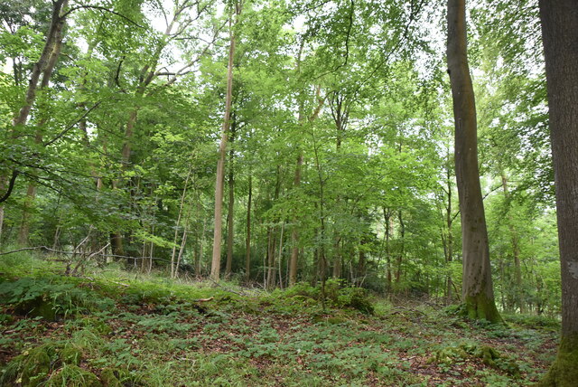
Crowsley Park Woods is a picturesque woodland located in Oxfordshire, England. Spanning over 100 acres, this dense forest is known for its natural beauty and diverse ecosystem. The woods are situated on the outskirts of the village of Crowsley, providing a tranquil escape from the bustle of urban life.

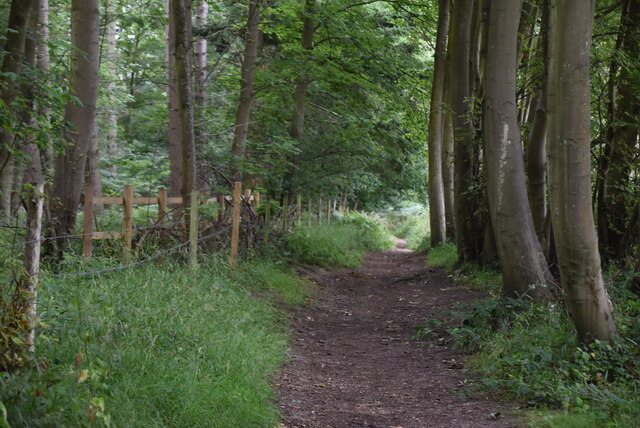
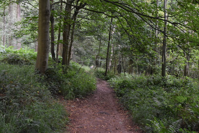
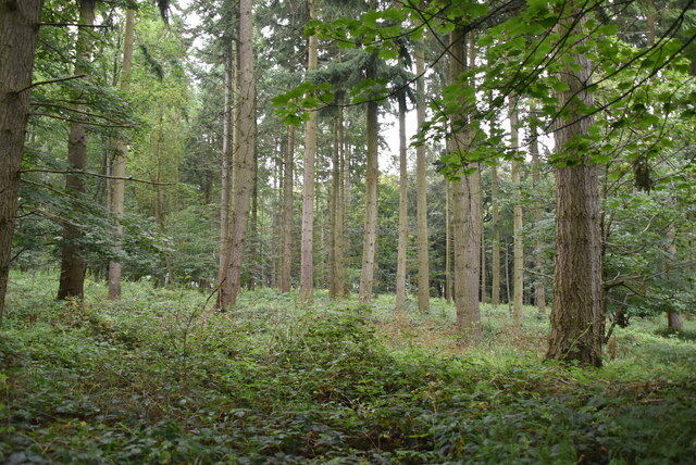
Upon entering the woods, visitors are greeted by a breathtaking canopy of tall, ancient trees, including oak, beech, and chestnut. The dense foliage creates a serene and shaded atmosphere, making it an ideal spot for nature enthusiasts and hikers alike. The forest floor is covered in a thick carpet of moss, ferns, and wildflowers, adding to the enchanting ambiance.

Crowsley Park Woods is also home to a wide variety of wildlife, making it a popular destination for birdwatchers and animal lovers. From woodpeckers and owls to foxes and rabbits, there is always something to discover within the woods' vibrant ecosystem. Nature trails wind through the forest, allowing visitors to explore and appreciate the diverse flora and fauna.

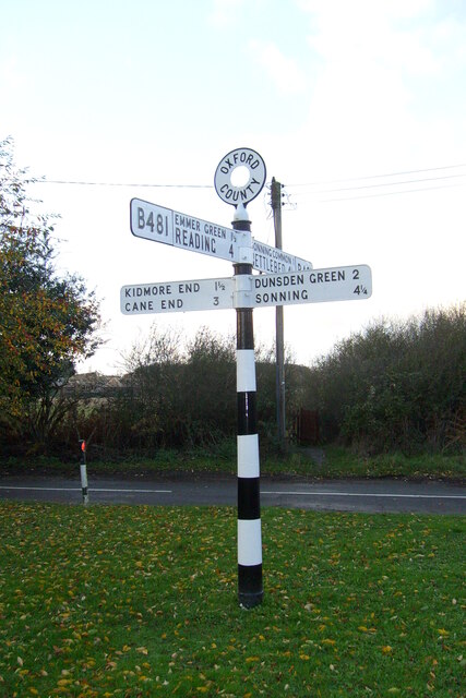
In addition to its natural beauty, Crowsley Park Woods holds historical significance. The woods were once part of the Crowsley Park estate, which dates back to the 16th century. Remnants of the estate can still be found within the woods, including the ruins of an old stone wall and a small pond.

Overall, Crowsley Park Woods offers a peaceful and enchanting retreat for those seeking solace in nature. Its stunning landscapes, diverse wildlife, and historical charm make it a must-visit destination for both locals and tourists alike.

If you have any feedback on the listing, please let us know in the comments section below.

Crowsley Park Woods Images

Images are sourced within 2km of 51.519943/-0.95218247 or Grid Reference SU7280. Thanks to Geograph Open Source API. All images are credited.

Direction Sign – Signpost on the B481, Sonning Common Located on the southwest side of the crossroads of the B481 Peppard Road and Bird in Hand Lane, opposite The Bird in Hand public house in Sonning Common parish. 4 arms and annulus finial. See also <a title="https://www.geograph.org.uk/photo/4070130" href="https://www.geograph.org.uk/photo/4070130">Link</a> and <a title="https://www.geograph.org.uk/photo/4070122" href="https://www.geograph.org.uk/photo/4070122">Link</a>.

Milestone Society National ID: OX_SU7179
Direction Sign – Signpost on the B481, Sonning Common
Located on the southwest side of the crossroads of the B481 Peppard Road and Bird in Hand Lane, opposite The Bird in Hand public house in Sonning Common parish. 4 arms and annulus finial. See also Link and Link. Milestone Society National ID: OX_SU7179
Crowsley Park Wood
Crowsley Park Wood
Farmland, Binfield Heath The footpath between Bishopsland and Crowsley follows the edge of this field of barley.
Farmland, Binfield Heath
The footpath between Bishopsland and Crowsley follows the edge of this field of barley.
Farmland, Sonning Common
Chiltern Way Created by the Chiltern Society as its Millennium Project, the Way originally took in all of the Chilterns from north to south across the Chilterns Area of Outstanding Natural Beauty, in a 125-miles circuit extending from Ewelme in the south west, Chorleywood in the south east and Sharpenhoe Clappers and Great Offley in the north east. It was based on an earlier unofficial route, the Chiltern Hundred.
The Way passes through some of the most attractive parts of the Chilterns, including the Bovingdon Plateau, the Chess valley, the Misbourne valley, Penn Country, the Hambleden valley, Stonor Park, Ewelme, Swyncombe Down, Bledlow Ridge, Hampden Country, Bulbourne valley and Dunstable Down.
The original 200km (125 miles) Way took in Hemel via Chalfont St Giles, the edge of Marlow, Hambleden, Bix Bottom, Ewelme, the Ridgeway, Stokenchurch, Great Hampden, Aldbury, the Dunstable Downs, Sharpenhoe Clappers and Harpenden.
Two extensions have been added in 2003: the southern adds a loop of 50km (35 miles) from Bix Bottom via Mapledurham on the Thames and the northern extension 44km (27 miles) from Sharpenhoe Clappers via the Icknield Way and the outskirts of Hitchin. A short cut from Bix Bottom creates a 16km (10 miles) loop via Ewelme.
Although officially starting at Hemel Hempstead Station, the walk can be started at many other places on the route. The Way also has links with other routes including Chiltern Heritage Trail, Ridgeway National Trail, Icknield Way Path, Oxfordshire, Swan's and South Bucks Ways and Grand Union Canal, Lea Valley and Chess Valley Walks.
Chiltern Way
Created by the Chiltern Society as its Millennium Project, the Way originally took in all of the Chilterns from north to south across the Chilterns Area of Outstanding Natural Beauty, in a 125-miles circuit extending from Ewelme in the south west, Chorleywood in the south east and Sharpenhoe Clappers and Great Offley in the north east. It was based on an earlier unofficial route, the Chiltern Hundred. The Way passes through some of the most attractive parts of the Chilterns, including the Bovingdon Plateau, the Chess valley, the Misbourne valley, Penn Country, the Hambleden valley, Stonor Park, Ewelme, Swyncombe Down, Bledlow Ridge, Hampden Country, Bulbourne valley and Dunstable Down. The original 200km (125 miles) Way took in Hemel via Chalfont St Giles, the edge of Marlow, Hambleden, Bix Bottom, Ewelme, the Ridgeway, Stokenchurch, Great Hampden, Aldbury, the Dunstable Downs, Sharpenhoe Clappers and Harpenden. Two extensions have been added in 2003: the southern adds a loop of 50km (35 miles) from Bix Bottom via Mapledurham on the Thames and the northern extension 44km (27 miles) from Sharpenhoe Clappers via the Icknield Way and the outskirts of Hitchin. A short cut from Bix Bottom creates a 16km (10 miles) loop via Ewelme. Although officially starting at Hemel Hempstead Station, the walk can be started at many other places on the route. The Way also has links with other routes including Chiltern Heritage Trail, Ridgeway National Trail, Icknield Way Path, Oxfordshire, Swan's and South Bucks Ways and Grand Union Canal, Lea Valley and Chess Valley Walks.
Crowsley Park Woods
Crowsley Park Woods
Chiltern Way Created by the Chiltern Society as its Millennium Project, the Way originally took in all of the Chilterns from north to south across the Chilterns Area of Outstanding Natural Beauty, in a 125-miles circuit extending from Ewelme in the south west, Chorleywood in the south east and Sharpenhoe Clappers and Great Offley in the north east. It was based on an earlier unofficial route, the Chiltern Hundred.
The Way passes through some of the most attractive parts of the Chilterns, including the Bovingdon Plateau, the Chess valley, the Misbourne valley, Penn Country, the Hambleden valley, Stonor Park, Ewelme, Swyncombe Down, Bledlow Ridge, Hampden Country, Bulbourne valley and Dunstable Down.
The original 200km (125 miles) Way took in Hemel via Chalfont St Giles, the edge of Marlow, Hambleden, Bix Bottom, Ewelme, the Ridgeway, Stokenchurch, Great Hampden, Aldbury, the Dunstable Downs, Sharpenhoe Clappers and Harpenden.
Two extensions have been added in 2003: the southern adds a loop of 50km (35 miles) from Bix Bottom via Mapledurham on the Thames and the northern extension 44km (27 miles) from Sharpenhoe Clappers via the Icknield Way and the outskirts of Hitchin. A short cut from Bix Bottom creates a 16km (10 miles) loop via Ewelme.
Although officially starting at Hemel Hempstead Station, the walk can be started at many other places on the route. The Way also has links with other routes including Chiltern Heritage Trail, Ridgeway National Trail, Icknield Way Path, Oxfordshire, Swan's and South Bucks Ways and Grand Union Canal, Lea Valley and Chess Valley Walks.
Chiltern Way
Created by the Chiltern Society as its Millennium Project, the Way originally took in all of the Chilterns from north to south across the Chilterns Area of Outstanding Natural Beauty, in a 125-miles circuit extending from Ewelme in the south west, Chorleywood in the south east and Sharpenhoe Clappers and Great Offley in the north east. It was based on an earlier unofficial route, the Chiltern Hundred. The Way passes through some of the most attractive parts of the Chilterns, including the Bovingdon Plateau, the Chess valley, the Misbourne valley, Penn Country, the Hambleden valley, Stonor Park, Ewelme, Swyncombe Down, Bledlow Ridge, Hampden Country, Bulbourne valley and Dunstable Down. The original 200km (125 miles) Way took in Hemel via Chalfont St Giles, the edge of Marlow, Hambleden, Bix Bottom, Ewelme, the Ridgeway, Stokenchurch, Great Hampden, Aldbury, the Dunstable Downs, Sharpenhoe Clappers and Harpenden. Two extensions have been added in 2003: the southern adds a loop of 50km (35 miles) from Bix Bottom via Mapledurham on the Thames and the northern extension 44km (27 miles) from Sharpenhoe Clappers via the Icknield Way and the outskirts of Hitchin. A short cut from Bix Bottom creates a 16km (10 miles) loop via Ewelme. Although officially starting at Hemel Hempstead Station, the walk can be started at many other places on the route. The Way also has links with other routes including Chiltern Heritage Trail, Ridgeway National Trail, Icknield Way Path, Oxfordshire, Swan's and South Bucks Ways and Grand Union Canal, Lea Valley and Chess Valley Walks.
Chiltern Way
Chiltern Way
Bones Wood
Bones Wood
Chiltern Way Created by the Chiltern Society as its Millennium Project, the Way originally took in all of the Chilterns from north to south across the Chilterns Area of Outstanding Natural Beauty, in a 125-miles circuit extending from Ewelme in the south west, Chorleywood in the south east and Sharpenhoe Clappers and Great Offley in the north east. It was based on an earlier unofficial route, the Chiltern Hundred.
The Way passes through some of the most attractive parts of the Chilterns, including the Bovingdon Plateau, the Chess valley, the Misbourne valley, Penn Country, the Hambleden valley, Stonor Park, Ewelme, Swyncombe Down, Bledlow Ridge, Hampden Country, Bulbourne valley and Dunstable Down.
The original 200km (125 miles) Way took in Hemel via Chalfont St Giles, the edge of Marlow, Hambleden, Bix Bottom, Ewelme, the Ridgeway, Stokenchurch, Great Hampden, Aldbury, the Dunstable Downs, Sharpenhoe Clappers and Harpenden.
Two extensions have been added in 2003: the southern adds a loop of 50km (35 miles) from Bix Bottom via Mapledurham on the Thames and the northern extension 44km (27 miles) from Sharpenhoe Clappers via the Icknield Way and the outskirts of Hitchin. A short cut from Bix Bottom creates a 16km (10 miles) loop via Ewelme.
Although officially starting at Hemel Hempstead Station, the walk can be started at many other places on the route. The Way also has links with other routes including Chiltern Heritage Trail, Ridgeway National Trail, Icknield Way Path, Oxfordshire, Swan's and South Bucks Ways and Grand Union Canal, Lea Valley and Chess Valley Walks.
Chiltern Way
Created by the Chiltern Society as its Millennium Project, the Way originally took in all of the Chilterns from north to south across the Chilterns Area of Outstanding Natural Beauty, in a 125-miles circuit extending from Ewelme in the south west, Chorleywood in the south east and Sharpenhoe Clappers and Great Offley in the north east. It was based on an earlier unofficial route, the Chiltern Hundred. The Way passes through some of the most attractive parts of the Chilterns, including the Bovingdon Plateau, the Chess valley, the Misbourne valley, Penn Country, the Hambleden valley, Stonor Park, Ewelme, Swyncombe Down, Bledlow Ridge, Hampden Country, Bulbourne valley and Dunstable Down. The original 200km (125 miles) Way took in Hemel via Chalfont St Giles, the edge of Marlow, Hambleden, Bix Bottom, Ewelme, the Ridgeway, Stokenchurch, Great Hampden, Aldbury, the Dunstable Downs, Sharpenhoe Clappers and Harpenden. Two extensions have been added in 2003: the southern adds a loop of 50km (35 miles) from Bix Bottom via Mapledurham on the Thames and the northern extension 44km (27 miles) from Sharpenhoe Clappers via the Icknield Way and the outskirts of Hitchin. A short cut from Bix Bottom creates a 16km (10 miles) loop via Ewelme. Although officially starting at Hemel Hempstead Station, the walk can be started at many other places on the route. The Way also has links with other routes including Chiltern Heritage Trail, Ridgeway National Trail, Icknield Way Path, Oxfordshire, Swan's and South Bucks Ways and Grand Union Canal, Lea Valley and Chess Valley Walks.
Bones Wood
Bones Wood
Chiltern Way Created by the Chiltern Society as its Millennium Project, the Way originally took in all of the Chilterns from north to south across the Chilterns Area of Outstanding Natural Beauty, in a 125-miles circuit extending from Ewelme in the south west, Chorleywood in the south east and Sharpenhoe Clappers and Great Offley in the north east. It was based on an earlier unofficial route, the Chiltern Hundred.
The Way passes through some of the most attractive parts of the Chilterns, including the Bovingdon Plateau, the Chess valley, the Misbourne valley, Penn Country, the Hambleden valley, Stonor Park, Ewelme, Swyncombe Down, Bledlow Ridge, Hampden Country, Bulbourne valley and Dunstable Down.
The original 200km (125 miles) Way took in Hemel via Chalfont St Giles, the edge of Marlow, Hambleden, Bix Bottom, Ewelme, the Ridgeway, Stokenchurch, Great Hampden, Aldbury, the Dunstable Downs, Sharpenhoe Clappers and Harpenden.
Two extensions have been added in 2003: the southern adds a loop of 50km (35 miles) from Bix Bottom via Mapledurham on the Thames and the northern extension 44km (27 miles) from Sharpenhoe Clappers via the Icknield Way and the outskirts of Hitchin. A short cut from Bix Bottom creates a 16km (10 miles) loop via Ewelme.
Although officially starting at Hemel Hempstead Station, the walk can be started at many other places on the route. The Way also has links with other routes including Chiltern Heritage Trail, Ridgeway National Trail, Icknield Way Path, Oxfordshire, Swan's and South Bucks Ways and Grand Union Canal, Lea Valley and Chess Valley Walks.
Chiltern Way
Created by the Chiltern Society as its Millennium Project, the Way originally took in all of the Chilterns from north to south across the Chilterns Area of Outstanding Natural Beauty, in a 125-miles circuit extending from Ewelme in the south west, Chorleywood in the south east and Sharpenhoe Clappers and Great Offley in the north east. It was based on an earlier unofficial route, the Chiltern Hundred. The Way passes through some of the most attractive parts of the Chilterns, including the Bovingdon Plateau, the Chess valley, the Misbourne valley, Penn Country, the Hambleden valley, Stonor Park, Ewelme, Swyncombe Down, Bledlow Ridge, Hampden Country, Bulbourne valley and Dunstable Down. The original 200km (125 miles) Way took in Hemel via Chalfont St Giles, the edge of Marlow, Hambleden, Bix Bottom, Ewelme, the Ridgeway, Stokenchurch, Great Hampden, Aldbury, the Dunstable Downs, Sharpenhoe Clappers and Harpenden. Two extensions have been added in 2003: the southern adds a loop of 50km (35 miles) from Bix Bottom via Mapledurham on the Thames and the northern extension 44km (27 miles) from Sharpenhoe Clappers via the Icknield Way and the outskirts of Hitchin. A short cut from Bix Bottom creates a 16km (10 miles) loop via Ewelme. Although officially starting at Hemel Hempstead Station, the walk can be started at many other places on the route. The Way also has links with other routes including Chiltern Heritage Trail, Ridgeway National Trail, Icknield Way Path, Oxfordshire, Swan's and South Bucks Ways and Grand Union Canal, Lea Valley and Chess Valley Walks.
Chiltern Way
Chiltern Way
Bones Wood
Bones Wood
Bones Wood
Bones Wood
Chiltern Way Created by the Chiltern Society as its Millennium Project, the Way originally took in all of the Chilterns from north to south across the Chilterns Area of Outstanding Natural Beauty, in a 125-miles circuit extending from Ewelme in the south west, Chorleywood in the south east and Sharpenhoe Clappers and Great Offley in the north east. It was based on an earlier unofficial route, the Chiltern Hundred.
The Way passes through some of the most attractive parts of the Chilterns, including the Bovingdon Plateau, the Chess valley, the Misbourne valley, Penn Country, the Hambleden valley, Stonor Park, Ewelme, Swyncombe Down, Bledlow Ridge, Hampden Country, Bulbourne valley and Dunstable Down.
The original 200km (125 miles) Way took in Hemel via Chalfont St Giles, the edge of Marlow, Hambleden, Bix Bottom, Ewelme, the Ridgeway, Stokenchurch, Great Hampden, Aldbury, the Dunstable Downs, Sharpenhoe Clappers and Harpenden.
Two extensions have been added in 2003: the southern adds a loop of 50km (35 miles) from Bix Bottom via Mapledurham on the Thames and the northern extension 44km (27 miles) from Sharpenhoe Clappers via the Icknield Way and the outskirts of Hitchin. A short cut from Bix Bottom creates a 16km (10 miles) loop via Ewelme.
Although officially starting at Hemel Hempstead Station, the walk can be started at many other places on the route. The Way also has links with other routes including Chiltern Heritage Trail, Ridgeway National Trail, Icknield Way Path, Oxfordshire, Swan's and South Bucks Ways and Grand Union Canal, Lea Valley and Chess Valley Walks.
Chiltern Way
Created by the Chiltern Society as its Millennium Project, the Way originally took in all of the Chilterns from north to south across the Chilterns Area of Outstanding Natural Beauty, in a 125-miles circuit extending from Ewelme in the south west, Chorleywood in the south east and Sharpenhoe Clappers and Great Offley in the north east. It was based on an earlier unofficial route, the Chiltern Hundred. The Way passes through some of the most attractive parts of the Chilterns, including the Bovingdon Plateau, the Chess valley, the Misbourne valley, Penn Country, the Hambleden valley, Stonor Park, Ewelme, Swyncombe Down, Bledlow Ridge, Hampden Country, Bulbourne valley and Dunstable Down. The original 200km (125 miles) Way took in Hemel via Chalfont St Giles, the edge of Marlow, Hambleden, Bix Bottom, Ewelme, the Ridgeway, Stokenchurch, Great Hampden, Aldbury, the Dunstable Downs, Sharpenhoe Clappers and Harpenden. Two extensions have been added in 2003: the southern adds a loop of 50km (35 miles) from Bix Bottom via Mapledurham on the Thames and the northern extension 44km (27 miles) from Sharpenhoe Clappers via the Icknield Way and the outskirts of Hitchin. A short cut from Bix Bottom creates a 16km (10 miles) loop via Ewelme. Although officially starting at Hemel Hempstead Station, the walk can be started at many other places on the route. The Way also has links with other routes including Chiltern Heritage Trail, Ridgeway National Trail, Icknield Way Path, Oxfordshire, Swan's and South Bucks Ways and Grand Union Canal, Lea Valley and Chess Valley Walks.
Bones Wood
Bones Wood
Bones Wood
Bones Wood
Show me another place!

Crowsley Park Woods is located at Grid Ref: SU7280 (Lat: 51.519943, Lng: -0.95218247)

Administrative County: Oxfordshire

District: South Oxfordshire

Police Authority: Thames Valley

What 3 Words

///tube.symphony.diplomas. Near Sonning Common, Oxfordshire

Related Wikis

Crowsley Park

Crowsley Park is a 160-acre (65 ha) country estate in South Oxfordshire, central-southern England, owned by the British Broadcasting Corporation (BBC)...

Rotherfield Peppard

Rotherfield Peppard (often referred to simply as Peppard by locals) is a village and civil parish in the Chiltern Hills in South Oxfordshire. It is centred...

Rotherfield Greys

Rotherfield Greys is a village and civil parish in the Chiltern Hills in South Oxfordshire. It is 2 miles (3 km) west of Henley-on-Thames and just over...

Sonning Common

Sonning Common is a village and civil parish in a relatively flat, former common land part of the Chiltern Hills in South Oxfordshire, centred 3.5 miles...

Gillotts School

Gillotts School is a coeducational secondary school with academy status in Henley-on-Thames, Oxfordshire, England. The school is sited on a 33 acre verdant...

Binfield Heath

Binfield Heath is a village and civil parish in South Oxfordshire, England, 2+1⁄2 miles (4 km) south-southwest of Henley-on-Thames and 3+1⁄2 miles (6 km...

Greys Court

Greys Court is a Tudor country house and gardens in the southern Chiltern Hills at Rotherfield Greys, near Henley-on-Thames in the county of Oxfordshire...

Maiden Erlegh Chiltern Edge

Maiden Erlegh Chiltern Edge (formerly Chiltern Edge Community School) is a coeducational secondary school located in Sonning Common, Oxfordshire, England...

Nearby Amenities

Located within 500m of 51.519943,-0.95218247
Disused Man Made: tower
Tower Construction: dish
Tower Type: communication
Lat/Long: 51.5172189/-0.950613
Man Made: tower
Tower Construction: dish
Tower Type: communication
Lat/Long: 51.5177319/-0.9525482
Man Made: tower
Tower Construction: dish
Tower Type: communication
Lat/Long: 51.5177356/-0.9518134
Man Made: tower
Tower Construction: dish
Tower Type: communication
Lat/Long: 51.5181967/-0.9537628
The data included in this document is from www.openstreetmap.org. The data is made available under ODbL.

Have you been to Crowsley Park Woods?

Leave your review of Crowsley Park Woods below (or comments, questions and feedback).