Ashgrove

Settlement in Morayshire

Scotland

Ashgrove
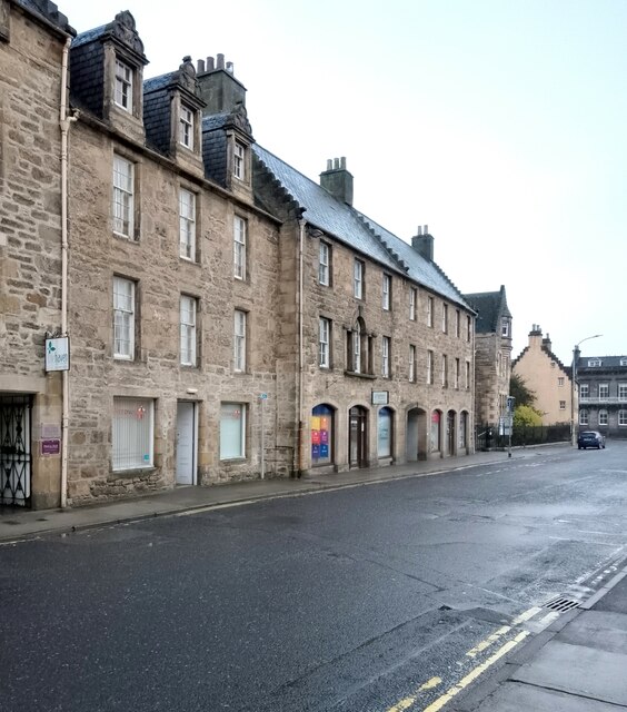
18th century buildings on High Street The closest of the buildings to the camera dates from about 1700, but was altered (including the addition of the dormer windows) in 1853. The adjacent building dates from 1728 but the ground floor was remodelled in 1971. It was formerly home of the Kilmolymock Lodge of Freemasons.

Both are Category B listed <span class="nowrap"><a title="https://portal.historicenvironment.scot/designation/LB30723" rel="nofollow ugc noopener" href="https://portal.historicenvironment.scot/designation/LB30723">Link</a><img style="margin-left:2px;" alt="External link" title="External link - shift click to open in new window" src="https://s1.geograph.org.uk/img/external.png" width="10" height="10"/></span> <span class="nowrap"><a title="https://portal.historicenvironment.scot/designation/LB30722" rel="nofollow ugc noopener" href="https://portal.historicenvironment.scot/designation/LB30722">Link</a><img style="margin-left:2px;" alt="External link" title="External link - shift click to open in new window" src="https://s1.geograph.org.uk/img/external.png" width="10" height="10"/></span>.
18th century buildings on High Street Credit: Richard Sutcliffe

Ashgrove is a small village located in the county of Morayshire, Scotland. Situated in the northeastern part of the country, it lies about 8 miles northwest of the town of Elgin. The village is nestled amidst picturesque countryside, boasting rolling hills, fertile farmland, and a charming rural setting.

With a population of around 500 residents, Ashgrove is a close-knit community known for its friendly atmosphere and warm hospitality. It offers a peaceful and tranquil lifestyle, making it an ideal place for families and those seeking a quieter pace of life. The village is characterized by its quaint cottages, traditional stone buildings, and well-maintained gardens.

Ashgrove benefits from its proximity to the larger town of Elgin, which provides a range of essential amenities and services such as schools, shops, healthcare facilities, and leisure activities. This allows residents to enjoy a rural lifestyle while still having access to modern conveniences.

The surrounding area offers plenty of opportunities for outdoor enthusiasts, with numerous walking and cycling paths, as well as fishing spots along the nearby River Lossie. Ashgrove is also conveniently located near the stunning Moray Coast, known for its sandy beaches, rugged cliffs, and wildlife.

Overall, Ashgrove is a charming village that offers a peaceful and idyllic setting for its residents. Its proximity to both rural and urban amenities makes it an attractive location for those seeking a balance between a tranquil countryside lifestyle and access to essential services.

If you have any feedback on the listing, please let us know in the comments section below.

Ashgrove Images

Images are sourced within 2km of 57.641152/-3.3082174 or Grid Reference NJ2262. Thanks to Geograph Open Source API. All images are credited.

18th century buildings on High Street The closest of the buildings to the camera dates from about 1700, but was altered (including the addition of the dormer windows) in 1853. The adjacent building dates from 1728 but the ground floor was remodelled in 1971. It was formerly home of the Kilmolymock Lodge of Freemasons.

Both are Category B listed <span class="nowrap"><a title="https://portal.historicenvironment.scot/designation/LB30723" rel="nofollow ugc noopener" href="https://portal.historicenvironment.scot/designation/LB30723">Link</a><img style="margin-left:2px;" alt="External link" title="External link - shift click to open in new window" src="https://s1.geograph.org.uk/img/external.png" width="10" height="10"/></span> <span class="nowrap"><a title="https://portal.historicenvironment.scot/designation/LB30722" rel="nofollow ugc noopener" href="https://portal.historicenvironment.scot/designation/LB30722">Link</a><img style="margin-left:2px;" alt="External link" title="External link - shift click to open in new window" src="https://s1.geograph.org.uk/img/external.png" width="10" height="10"/></span>.
18th century buildings on High Street
The closest of the buildings to the camera dates from about 1700, but was altered (including the addition of the dormer windows) in 1853. The adjacent building dates from 1728 but the ground floor was remodelled in 1971. It was formerly home of the Kilmolymock Lodge of Freemasons. Both are Category B listed LinkExternal link LinkExternal link.
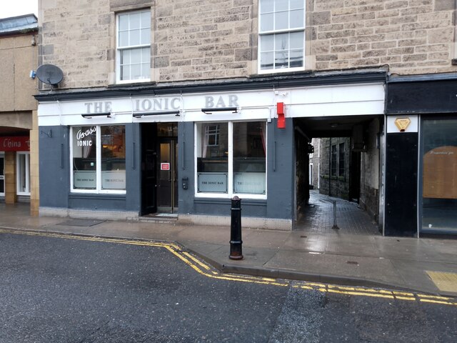
The Ionic Bar On High Street, Elgin.
The Ionic Bar
On High Street, Elgin.
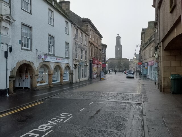
High Street, Elgin Looking towards St Giles Church.
High Street, Elgin
Looking towards St Giles Church.
St Sylvester's Nursery At the corner of Abbey Street and Institution Road.
St Sylvester's Nursery
At the corner of Abbey Street and Institution Road.
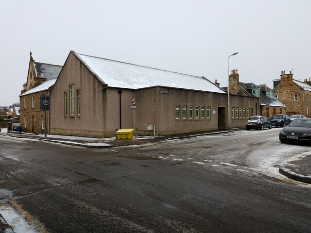
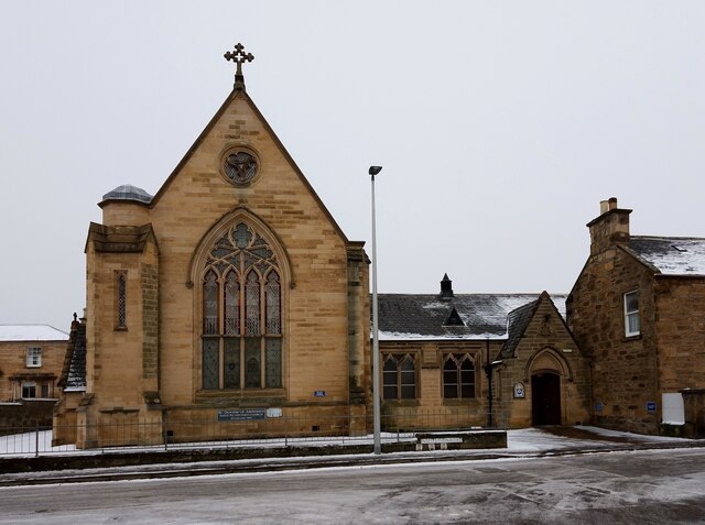
St Sylvester's Church Category B listed <span class="nowrap"><a title="https://portal.historicenvironment.scot/designation/LB30806" rel="nofollow ugc noopener" href="https://portal.historicenvironment.scot/designation/LB30806">Link</a><img style="margin-left:2px;" alt="External link" title="External link - shift click to open in new window" src="https://s1.geograph.org.uk/img/external.png" width="10" height="10"/></span> Roman Catholic church on Institution Road, dating from 1843. Attached to it is a schoolroom dating from 1872.
St Sylvester's Church
Category B listed LinkExternal link Roman Catholic church on Institution Road, dating from 1843. Attached to it is a schoolroom dating from 1872.
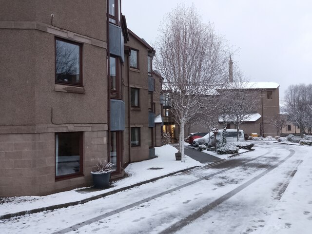
West Park Court Sheltered housing managed by Hanover Scotland Housing Association.
West Park Court
Sheltered housing managed by Hanover Scotland Housing Association.
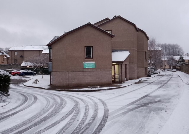
Tracks in the snow Outside West Park Court, sheltered housing managed by Hanover Scotland Housing Association.
Tracks in the snow
Outside West Park Court, sheltered housing managed by Hanover Scotland Housing Association.
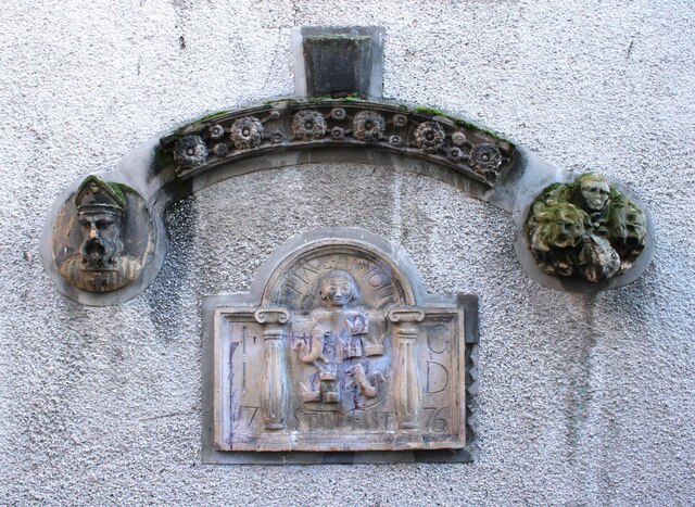
Marriage stone Incorporated into the wall of Harrow Inn Close.
Marriage stone
Incorporated into the wall of Harrow Inn Close.
Pansport Place The former council housing around Pans Port is of good solid stone construction.
Pansport Place
The former council housing around Pans Port is of good solid stone construction.
Pansport Place Some of the substantial stone council housing near Pans Port.
Pansport Place
Some of the substantial stone council housing near Pans Port.
Mediaeval Masonry This fragment of masonry in Pansport Place is a remnant of the wall which once surrounded the Cathedral precinct. And yes, it is at a slightly odd angle compared to the council house behind.
Mediaeval Masonry
This fragment of masonry in Pansport Place is a remnant of the wall which once surrounded the Cathedral precinct. And yes, it is at a slightly odd angle compared to the council house behind.
South College House In its heyday the Cathedral, of which the towers can be seen in the background, was surrounded by the manses of the Cathedral officers and dignitaries. The names North and South College recall two of these. The actual building now on the site of South College is of a much later date, though parts of the 16th century building may lurk under the later walls.
South College House
In its heyday the Cathedral, of which the towers can be seen in the background, was surrounded by the manses of the Cathedral officers and dignitaries. The names North and South College recall two of these. The actual building now on the site of South College is of a much later date, though parts of the 16th century building may lurk under the later walls.
South College House Detail The west doorway of South College House has some architectural features including an ornate gable and wrought iron balcony.
South College House Detail
The west doorway of South College House has some architectural features including an ornate gable and wrought iron balcony.
An Intricate Wrought Iron Balcony A close view of the balcony above the west door of South College House.
An Intricate Wrought Iron Balcony
A close view of the balcony above the west door of South College House.
Cathedral West Towers The west towers of the Cathedral from the access to the west side of South College House, with an attractive old-fashioned street lamp.
Cathedral West Towers
The west towers of the Cathedral from the access to the west side of South College House, with an attractive old-fashioned street lamp.
Rear of No 2 King Street It was the beautiful laburnum which caught my eye, but the building is a classic Georgian house. It dates from about 1820 and is a category B listed building. The architect is unknown but it is described as being in the style of William Robertson.
Rear of No 2 King Street
It was the beautiful laburnum which caught my eye, but the building is a classic Georgian house. It dates from about 1820 and is a category B listed building. The architect is unknown but it is described as being in the style of William Robertson.
King Street King Street, now a cul-de-sac, was one of the streets in the Cathedral precinct where the manses of the Cathedral officers stood in mediaeval times. The present houses are mainly of early 19th century date.
King Street
King Street, now a cul-de-sac, was one of the streets in the Cathedral precinct where the manses of the Cathedral officers stood in mediaeval times. The present houses are mainly of early 19th century date.
Gate Lodge This little gate lodge stands beside one of the entrances to the Cooper Park from North College Street. It is probably Victorian.
Gate Lodge
This little gate lodge stands beside one of the entrances to the Cooper Park from North College Street. It is probably Victorian.
Show me another place!

Ashgrove is located at Grid Ref: NJ2262 (Lat: 57.641152, Lng: -3.3082174)

Unitary Authority: Moray

Police Authority: North East

What 3 Words

///kinds.panels.flock. Near Elgin, Moray

Related Wikis

Elgin railway station

Elgin railway station is a railway station serving the town of Elgin, Moray in Scotland. The station is managed and served by ScotRail and is on the Aberdeen...

Ashgrove, Moray

Ashgrove is a village in Moray, Scotland.

Moray College

Moray College (Scottish Gaelic: Colaiste Mhoireibh) is a further education college based in Elgin, in Moray, northeastern Scotland. It has 1,500 full-time...

Gordon & MacPhail

Gordon & MacPhail is an independent bottler and distiller of Scotch Whisky, founded in 1895 and located in Elgin in the north-east of Scotland. It is a...

Nearby Amenities

Located within 500m of 57.641152,-3.3082174
Elgin
Name Gd: Eilginn
Naptan AtcoCode: 9100ELGIN
Network: National Rail
Network Website: https://www.nationalrail.co.uk/stations/elg/
Network Wikidata: Q26334
Operator: ScotRail
Operator Website: https://www.scotrail.co.uk/plan-your-journey/stations-and-facilities/elg
Operator Wikidata: Q18356161
Public Transport: station
Railway: station
Ref Crs: ELG
Source: NPE
Train: yes
Wheelchair: yes
Wikidata: Q2396399
Wikipedia: en:Elgin railway station
Lat/Long: 57.6427835/-3.310943
Railway: switch
Lat/Long: 57.6428047/-3.3091446
Post Box
Operator: Royal Mail
Operator Wikidata: Q638098
Post Box Type: lamp
Ref: IV30 136
Royal Cypher: scottish_crown
Lat/Long: 57.6421786/-3.3001217
Bus Stop
Bus: yes
Naptan AtcoCode: 638055336
Naptan NaptanCode: 67925327
Public Transport: platform
Wheelchair: yes
Lat/Long: 57.640574/-3.312151
Bus Stop
Lat/Long: 57.6433808/-3.3111645
Bus Stop
New Elgin Road
Bus: yes
Naptan AtcoCode: 638050491
Naptan Bearing: E
Naptan CommonName: New Elgin Road
Naptan Indicator: E-bound
Naptan NaptanCode: 67923473
Naptan PlusbusZoneRef: ELGIN
Naptan Street: Linkwood Road
Naptan Verified: no
Public Transport: platform
Wheelchair: yes
Lat/Long: 57.6418084/-3.3048459
Bus Stop
New Elgin Road
Bus: yes
Naptan AtcoCode: 638050492
Naptan Bearing: W
Naptan CommonName: New Elgin Road
Naptan Indicator: W-bound
Naptan NaptanCode: 67924959
Naptan PlusbusZoneRef: ELGIN
Naptan Street: Linkwood Road
Naptan Verified: no
Public Transport: platform
Wheelchair: yes
Lat/Long: 57.6417108/-3.30476
Bus Stop
Naptan AtcoCode: 638050472
Naptan NaptanCode: 67923863
Wheelchair: yes
Lat/Long: 57.6377332/-3.3090206
Crossing
Button Operated: yes
Crossing: traffic_signals
Crossing Ref: pelican
Lat/Long: 57.6389812/-3.3033114
Bus Stop
Wheelchair: yes
Lat/Long: 57.6379019/-3.3035074
Railway: switch
Lat/Long: 57.644388/-3.3036354
Railway: switch
Lat/Long: 57.6443253/-3.3034089
Elgin East
Historic Railway: station
Wikidata: Q17825239
Lat/Long: 57.6429596/-3.3072494
Railway: switch
Lat/Long: 57.643854/-3.3041825
Railway: switch
Lat/Long: 57.643366/-3.3049336
Railway: switch
Lat/Long: 57.6427925/-3.3019549
Noexit: yes
Lat/Long: 57.6395235/-3.3107549
Crossing
Crossing: marked
Crossing Markings: yes
Lat/Long: 57.6417138/-3.3100915
Crossing
Crossing: marked
Crossing Markings: yes
Lat/Long: 57.6419379/-3.3086887
Crossing
Crossing: marked
Crossing Markings: yes
Lat/Long: 57.6419357/-3.3096342
Mini Roundabout
Direction: clockwise
Lat/Long: 57.6407774/-3.3080607
Noexit: yes
Lat/Long: 57.6409722/-3.3095502
Noexit: yes
Lat/Long: 57.6408569/-3.3093777
New Elgin
Place: suburb
Lat/Long: 57.6367392/-3.3077192
Addr Housenumber: 113
Addr Street: Muirfield Road
Entrance: yes
Lat/Long: 57.6367958/-3.3101338
Addr Housenumber: 115
Addr Street: Muirfield Road
Entrance: yes
Lat/Long: 57.6368229/-3.3100714
Addr Housenumber: 119
Addr Street: Muirfield Road
Entrance: yes
Lat/Long: 57.6368792/-3.3099419
Addr Housenumber: 117
Addr Street: Muirfield Road
Entrance: yes
Lat/Long: 57.6368524/-3.3100037
Addr Housenumber: 121
Addr Street: Muirfield Road
Entrance: yes
Lat/Long: 57.6369467/-3.3097884
Addr Housenumber: 123
Addr Street: Muirfield Road
Entrance: yes
Lat/Long: 57.636978/-3.3097173
Addr Housenumber: 62
Addr Street: Bailies Drive
Entrance: yes
Lat/Long: 57.6380557/-3.3106882
Addr Housenumber: 56
Addr Street: Bailies Drive
Entrance: yes
Lat/Long: 57.6382155/-3.3107746
Addr Housenumber: 60
Addr Street: Bailies Drive
Entrance: yes
Lat/Long: 57.6381125/-3.3107189
Addr Housenumber: 58
Addr Street: Bailies Drive
Entrance: yes
Lat/Long: 57.6381674/-3.3107486
Post Box
Post Box Type: wall
Ref: IV30 10
Lat/Long: 57.6389073/-3.3033869
Traffic Signals
Traffic Signals: emergency
Traffic Signals Direction: both
Lat/Long: 57.6434214/-3.3127663
Ladbrokes
Brand: Ladbrokes
Brand Wikidata: Q1799875
Brand Wikipedia: en:Ladbrokes Coral
Shop: bookmaker
Lat/Long: 57.6379013/-3.3038834
Fast Food
Happy City
Addr Housenumber: 30
Addr Postcode: IV30 6BH
Addr Street: Main Street
Cuisine: chinese
Fhrs Id: 19199
Source Addr: FHRS Open Data
Lat/Long: 57.6375697/-3.3040658
Railway: switch
Lat/Long: 57.6445216/-3.3030373
Pub
Caberfeidh Bar
Addr City: Elgin
Addr Postcode: IV30 6BH
Addr Street: Main Street
Fhrs Id: 19192
Lat/Long: 57.6378254/-3.3039846
Railway: signal
Railway Signal Main: GB-NR:main
Ref: HE7743
Lat/Long: 57.6428048/-3.3140503
Railway: signal
Railway Signal Main: GB-NR:main
Ref: HE7738
Lat/Long: 57.6427673/-3.3094436
Railway: signal
Railway Signal Main: GB-NR:main
Railway Signal Shunting: GB-NR:shunting
Ref: HE7736
Lat/Long: 57.6428039/-3.3094409
Railway: switch
Lat/Long: 57.6429317/-3.3075714
Railway: signal
Railway Signal Main: GB-NR:main
Ref: HE7741
Lat/Long: 57.6427756/-3.3124116
Taxi
Lat/Long: 57.6429831/-3.3116439
Richmond Bed & Breakfast
Guest House: bed_and_breakfast
Tourism: guest_house
Lat/Long: 57.6454268/-3.3103115
Cafe
Asda Café
Brand: Asda
Brand Wikidata: Q297410
Brand Wikipedia: en:Asda
Contact Phone: +44 1343 564000
Contact Website: https://storelocator.asda.com/scotland/elgin/edgar-road/cafe
Cuisine: coffee_shop
Drinking Water Refill: yes
Drinking Water Refill Network: Refill
Fixme: Location not accurate
Internet Access: wlan
Internet Access Fee: no
Opening Hours Covid19: Mo-Su off
Operator: Asda Stores Ltd
Takeaway: yes
Lat/Long: 57.6418866/-3.3102858
Design: h-frame
Material: wood
Power: pole
Lat/Long: 57.6426597/-3.3005047
Crossing
Crossing: marked
Crossing Markings: yes
Lat/Long: 57.6415734/-3.3100911
Crossing
Crossing: marked
Crossing Markings: yes
Lat/Long: 57.6414338/-3.3100924
Post Box
Brand: Royal Mail
Brand Wikidata: Q638098
Mapillary: 460353341862230
Operator: Royal Mail
Operator Wikidata: Q638098
Post Box Mounting: stone_wall
Post Box Type: wall
Lat/Long: 57.643966/-3.3088564
Man Made: mast
Tower Type: communication
Lat/Long: 57.6431315/-3.3120378
Traffic Signals
Traffic Signals: emergency
Traffic Signals Direction: both
Lat/Long: 57.643358/-3.3120447
Noexit: yes
Lat/Long: 57.6407437/-3.309203
Atm
Brand: Barclays
Brand Wikidata: Q245343
Operator: Barclays
Operator Wikidata: Q245343
Lat/Long: 57.6423985/-3.3100001
Atm
Brand: Barclays
Brand Wikidata: Q245343
Operator: Barclays
Operator Wikidata: Q245343
Lat/Long: 57.6423791/-3.3100003
Bicycle Parking
Lat/Long: 57.6418385/-3.3099758
Crossing
Crossing: uncontrolled
Crossing Markings: yes
Lat/Long: 57.6425865/-3.3097656
Crossing
Crossing: uncontrolled
Crossing Markings: yes
Lat/Long: 57.6426076/-3.310083
Turning Circle
Turning Circle: square
Lat/Long: 57.6425115/-3.3116173
Bus Stop
Bus: yes
Naptan AtcoCode: 638053721
Naptan NaptanCode: 67923467
Public Transport: platform
Shelter: yes
Lat/Long: 57.6411075/-3.3100592
Turning Circle
Lat/Long: 57.6409242/-3.314095
Crossing
Crossing: unmarked
Crossing Island: no
Crossing Markings: no
Tactile Paving: yes
Lat/Long: 57.6399947/-3.3156924
Bus Stop
Bus: yes
Naptan AtcoCode: 638055338
Naptan NaptanCode: 67925345
Public Transport: platform
Wheelchair: yes
Lat/Long: 57.6402636/-3.3143371
Turning Circle
Lat/Long: 57.6414967/-3.3161544
Crossing
Lat/Long: 57.6401331/-3.3159793
Crossing
Lat/Long: 57.6406867/-3.3164226
Access: private
Barrier: lift_gate
Lift Gate Type: single
Lat/Long: 57.6405358/-3.3138115
Turning Circle
Lat/Long: 57.6402249/-3.3122276
Turning Circle
Lat/Long: 57.640204/-3.3086638
Barrier: lift_gate
Lift Gate Type: single
Lat/Long: 57.6417781/-3.3082919
Barrier: lift_gate
Lift Gate Type: single
Lat/Long: 57.6417774/-3.3081753
Power: transformer
Lat/Long: 57.6424605/-3.3007595
Power: transformer
Lat/Long: 57.6425692/-3.3005758
Noexit: yes
Lat/Long: 57.6397836/-3.3155163
Turning Circle
Lat/Long: 57.6443626/-3.3028345
Turning Circle
Lat/Long: 57.6432097/-3.3023362
Turning Circle
Lat/Long: 57.6429992/-3.3019385
Turning Circle
Turning Circle: knuckle
Lat/Long: 57.6428867/-3.3108989
Bench
Lat/Long: 57.6454231/-3.3069753
Bench
Lat/Long: 57.6453452/-3.3068577
Bench
Lat/Long: 57.6452565/-3.3067238
Bench
Lat/Long: 57.6454773/-3.3061418
IV30
Leisure: outdoor_seating
Operator: The Laichmoray Hotel
Lat/Long: 57.6439195/-3.3087585
The Garden
Leisure: outdoor_seating
Operator: The Laichmoray Hotel
Lat/Long: 57.6440941/-3.3088363
Historic Railway: junction
Wikidata: Q124285369
Lat/Long: 57.6428075/-3.3090268
Communication Radio: yes
Man Made: mast
Tower Construction: freestanding
Tower Type: communication
Lat/Long: 57.6428971/-3.3065349
Railway: level_crossing
Lat/Long: 57.6431481/-3.3062899
Railway: level_crossing
Lat/Long: 57.643234/-3.3063973
Car Rental
Enterprise
Addr City: Elgin
Addr Housename: Unit 8 Elgin Business Centre
Addr Postcode: IV30 1QP
Addr Street: Maisondieu Road
Brand: Enterprise
Brand Wikidata: Q17085454
Official Name: Enterprise Rent-A-Car
Lat/Long: 57.6435162/-3.3079241
Entrance: main
Lat/Long: 57.6408563/-3.3072997
Crossing
Lat/Long: 57.6407529/-3.3081625
Crossing
Lat/Long: 57.6410842/-3.3095748
Crossing
Lat/Long: 57.640927/-3.3104038
Crossing
Lat/Long: 57.6407168/-3.3114511
Crossing
Lat/Long: 57.6404619/-3.3127369
Crossing
Lat/Long: 57.6404082/-3.3130066
Crossing
Lat/Long: 57.6403124/-3.3134958
Crossing
Lat/Long: 57.6401099/-3.3145263
Crossing
Lat/Long: 57.6399832/-3.3151616
Crossing
Lat/Long: 57.6398693/-3.3156675
Crossing
Lat/Long: 57.6397424/-3.3161418
Crossing
Crossing: traffic_signals
Lat/Long: 57.6411755/-3.3092315
Crossing
Lat/Long: 57.6407894/-3.3116839
Crossing
Lat/Long: 57.6405051/-3.3132013
Crossing
Lat/Long: 57.6404073/-3.3137192
Crossing
Lat/Long: 57.6398361/-3.3158877
Crossing
Lat/Long: 57.6398876/-3.3159329
Crossing
Lat/Long: 57.6401041/-3.3149933
Crossing
Lat/Long: 57.6400504/-3.3149537
Crossing
Lat/Long: 57.6415154/-3.3084208
Crossing
Lat/Long: 57.6415177/-3.3085047
Crossing
Lat/Long: 57.6433434/-3.3123812
Crossing
Lat/Long: 57.6431919/-3.3137362
Crossing
Lat/Long: 57.6431674/-3.3109739
Crossing
Lat/Long: 57.6432869/-3.311864
The data included in this document is from www.openstreetmap.org. The data is made available under ODbL.

Have you been to Ashgrove?

Leave your review of Ashgrove below (or comments, questions and feedback).