Birch Copse

Wood, Forest in Northamptonshire

England

Birch Copse

Whittlebury (South) The southern part of Whittlebury with the Fox & Hounds pub (the white building, see <a href="https://www.geograph.org.uk/photo/189204">SP6943 : The Fox and Hounds, Whittlebury</a>).
Whittlebury (South) Credit: Rob Farrow

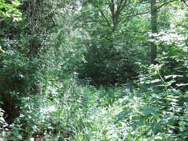
Birch Copse is a charming woodland area located in Northamptonshire, England. Spread across several acres, it is a natural haven for both locals and visitors alike. The copse is predominantly made up of birch trees, hence its name, and offers a peaceful and picturesque setting.

The woodland features a well-maintained network of footpaths, allowing visitors to explore its beauty at their own pace. These paths meander through the tall, slender birch trees, creating a stunning visual display throughout the year. In spring, the copse is adorned with delicate white blossoms, while autumn brings a vibrant tapestry of golden leaves.

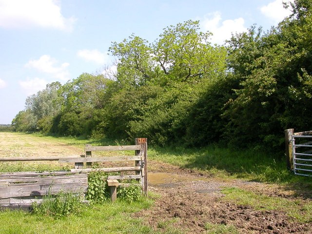
The copse is home to a variety of wildlife, making it a popular spot for nature enthusiasts. Birdwatchers can observe a multitude of species, including woodpeckers, thrushes, and owls. Squirrels and rabbits can also be spotted darting among the trees, adding to the woodland's natural charm.

For those seeking tranquility or a place to relax, Birch Copse provides several secluded areas equipped with benches or picnic tables. Visitors can enjoy a peaceful moment surrounded by the sights and sounds of nature.

Birch Copse is easily accessible, with a nearby car park and public transportation options. The copse is maintained by the local authorities, ensuring its cleanliness and safety for all visitors.

Overall, Birch Copse offers a serene escape from the hustle and bustle of everyday life. Its beautiful birch trees, diverse wildlife, and tranquil atmosphere make it a must-visit destination for nature lovers and those seeking a peaceful retreat.

If you have any feedback on the listing, please let us know in the comments section below.

Birch Copse Images

Images are sourced within 2km of 52.075573/-0.97881228 or Grid Reference SP7042. Thanks to Geograph Open Source API. All images are credited.

Whittlebury (South) The southern part of Whittlebury with the Fox & Hounds pub (the white building, see <a href="https://www.geograph.org.uk/photo/189204">SP6943 : The Fox and Hounds, Whittlebury</a>).
Whittlebury (South)
The southern part of Whittlebury with the Fox & Hounds pub (the white building, see SP6943 : The Fox and Hounds, Whittlebury).
West Park Farm A mare and her foal nibble the grass in front of West Park Farm. Near to Whittlebury this lovely old farm obviously belonged to a Gentleman Farmer in the past. Much of its land is now taken over by Whittlebury Park Golf Course.
West Park Farm
A mare and her foal nibble the grass in front of West Park Farm. Near to Whittlebury this lovely old farm obviously belonged to a Gentleman Farmer in the past. Much of its land is now taken over by Whittlebury Park Golf Course.
Whittlebury Park Hotel The frontage of the large hotel that forms part of the substantial Whittlebury Park Golf and Country Club.
Whittlebury Park Hotel
The frontage of the large hotel that forms part of the substantial Whittlebury Park Golf and Country Club.
Drive to Coldthorn Perpendicular to the A413 this drive leads to a property called "Coldthorn".
Drive to Coldthorn
Perpendicular to the A413 this drive leads to a property called "Coldthorn".
A413 County Border Here the A413 passes between Shirehill Wood and Lovel Wood. Where the road exits these two woods (which you can just see) is the boundary between Buckinghamshire to the south and Northamptonshire to the north.
A413 County Border
Here the A413 passes between Shirehill Wood and Lovel Wood. Where the road exits these two woods (which you can just see) is the boundary between Buckinghamshire to the south and Northamptonshire to the north.
Church Way, Whittlebury The High Street sign refers to the road in the foreground which is the A413 through Whittlebury. The road snaking off ahead is Church Way.
Church Way, Whittlebury
The High Street sign refers to the road in the foreground which is the A413 through Whittlebury. The road snaking off ahead is Church Way.
The Fox and Hounds, Whittlebury Close up of the pub seen in <a href="https://www.geograph.org.uk/photo/187607">SP6943 : Whittlebury (South)</a>
The Fox and Hounds, Whittlebury
Close up of the pub seen in SP6943 : Whittlebury (South)
West Park Farm - The Farmhouse A close-up of the farmhouse with a massive Cedar to the right.
West Park Farm - The Farmhouse
A close-up of the farmhouse with a massive Cedar to the right.
View near Coldthorn Looking across the A413 by the drive to Coldthorn towards Whittlebury Park Golf Club, the hotel & clubhouse can be seen in the distance, part of the golfcourse lying between.
View near Coldthorn
Looking across the A413 by the drive to Coldthorn towards Whittlebury Park Golf Club, the hotel & clubhouse can be seen in the distance, part of the golfcourse lying between.
Lovel Wood Dense undergrowth and trees in Lovel Wood beside the A413 near the Bucks/Northants border.
Lovel Wood
Dense undergrowth and trees in Lovel Wood beside the A413 near the Bucks/Northants border.
Triangle road junction near Lillingstone Lovell The main A413 road from Buckingham to Towcester runs across the photo, the road from Lillingstone Lovell splits into two approaching it and encloses a grassy triangle.
Triangle road junction near Lillingstone Lovell
The main A413 road from Buckingham to Towcester runs across the photo, the road from Lillingstone Lovell splits into two approaching it and encloses a grassy triangle.
Whittlebury Footpath running north of Buckingham Thick Copse.
Whittlebury
Footpath running north of Buckingham Thick Copse.
Whittlebury A Clearing in old Tun Copse.
Whittlebury
A Clearing in old Tun Copse.
Whittlebury Road leading down to Home Farm.
Whittlebury
Road leading down to Home Farm.
Whittlebury The road at the edge of Birch Copse.
Whittlebury
The road at the edge of Birch Copse.
Whittlebury Farmland north of Linshire Copse.
Whittlebury
Farmland north of Linshire Copse.
Lillingstone Lovell The Spinney near the Manor House.
Lillingstone Lovell
The Spinney near the Manor House.
Path through Shirehill Wood I don't think this path has been used in a very long time. From here you could hear the buzz of cars racing around Silverstone circuit.
Path through Shirehill Wood
I don't think this path has been used in a very long time. From here you could hear the buzz of cars racing around Silverstone circuit.
Show me another place!

Birch Copse is located at Grid Ref: SP7042 (Lat: 52.075573, Lng: -0.97881228)

Unitary Authority: West Northamptonshire

Police Authority: Northamptonshire

What 3 Words

///reinstate.squeaking.slope. Near Silverstone, Northamptonshire

Related Wikis

Whittlebury

Whittlebury is a village and civil parish in the south of the English county of Northamptonshire, close to its border with Buckinghamshire. == History... ==

Whittlewood Forest

Whittlewood Forest is a former medieval hunting forest east of Silverstone in Northamptonshire in England. It is managed by the Forestry England. There...

Lillingstone Lovell

Lillingstone Lovell is a village and civil parish in north Buckinghamshire, England. It is located around 4 miles (6.4 km) north of Buckingham and 8 miles...

RAF Silverstone

Royal Air Force Silverstone or more simply RAF Silverstone is a former Royal Air Force (RAF) station, the site is now used as Silverstone Circuit. It straddles...

Silverstone Heliport

Silverstone Heliport (ICAO: EGBV) is 5 nautical miles (9.3 km; 5.8 mi) north of Buckingham, Buckinghamshire, England and within the mid-east of the Silverstone...

Development history of Silverstone Circuit

Silverstone Circuit is built on the site of a World War II Royal Air Force bomber station, RAF Silverstone, which opened in 1943. The airfield's three...

Silverstone University Technical College

Silverstone University Technical College (or Silverstone UTC) is a university technical college (UTC) that opened at the Silverstone Circuit in Northamptonshire...

2007 British Grand Prix

The 2007 British Grand Prix (formally the 2007 Formula 1 Santander British Grand Prix) was the ninth race of the 2007 FIA Formula One World Championship...

Nearby Amenities

Located within 500m of 52.075573,-0.97881228
The data included in this document is from www.openstreetmap.org. The data is made available under ODbL.

Have you been to Birch Copse?

Leave your review of Birch Copse below (or comments, questions and feedback).