Conduit Spinney

Wood, Forest in Leicestershire Harborough

England

Conduit Spinney

Quenby Hall Listed Grade I. Described by Sir Nikolaus Pevsner as "the most important early-seventeenth century house in the county" <span class="nowrap"><a title="https://en.wikipedia.org/wiki/Quenby_Hall" rel="nofollow ugc noopener" href="https://en.wikipedia.org/wiki/Quenby_Hall">Link</a><img style="margin-left:2px;" alt="External link" title="External link - shift click to open in new window" src="https://s1.geograph.org.uk/img/external.png" width="10" height="10"/></span>
Quenby Hall Credit: Tim Heaton

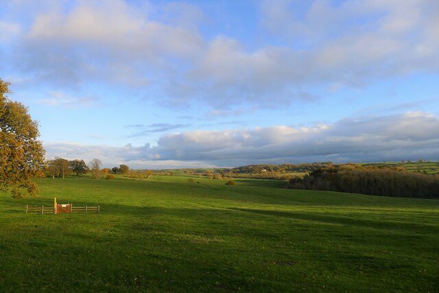
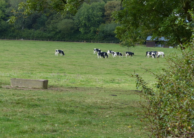
Conduit Spinney is a picturesque woodland located in Leicestershire, England. Situated near the village of Woodhouse Eaves, this forested area covers approximately 30 acres and is a popular destination for nature enthusiasts and hikers.

The woodland is characterized by its diverse range of tree species, including oak, beech, and ash. These towering trees create a dense canopy, providing a shady and tranquil environment for visitors to explore. The forest floor is adorned with a rich carpet of wildflowers, adding bursts of color to the serene landscape.

Conduit Spinney is intersected by a winding network of footpaths, allowing visitors to easily navigate through the woodland. The well-maintained trails offer opportunities for leisurely walks, jogging, or even cycling.

The forest is also home to a variety of wildlife, making it an ideal spot for birdwatching and nature photography. Visitors may catch glimpses of woodpeckers, songbirds, and even the occasional deer.

In addition to its natural beauty, Conduit Spinney holds historical significance. The woodland is named after a historic conduit or water channel that once ran through the area, supplying water to nearby villages. While the conduit is no longer in use, remnants of its stone structure can still be seen within the woodland.

Overall, Conduit Spinney in Leicestershire offers a peaceful and enchanting retreat for those seeking to immerse themselves in nature's beauty. Whether for a leisurely stroll or a deeper exploration of the forest's flora and fauna, this woodland provides a wonderful escape from the hustle and bustle of everyday life.

If you have any feedback on the listing, please let us know in the comments section below.

Conduit Spinney Images

Images are sourced within 2km of 52.641578/-0.97967888 or Grid Reference SK6905. Thanks to Geograph Open Source API. All images are credited.

Quenby Hall Listed Grade I. Described by Sir Nikolaus Pevsner as "the most important early-seventeenth century house in the county" <span class="nowrap"><a title="https://en.wikipedia.org/wiki/Quenby_Hall" rel="nofollow ugc noopener" href="https://en.wikipedia.org/wiki/Quenby_Hall">Link</a><img style="margin-left:2px;" alt="External link" title="External link - shift click to open in new window" src="https://s1.geograph.org.uk/img/external.png" width="10" height="10"/></span>
Quenby Hall
Listed Grade I. Described by Sir Nikolaus Pevsner as "the most important early-seventeenth century house in the county" LinkExternal link
'High Leicestershire'; view south-east of Quenby Hall "This landscape of broad, rolling ridges and secluded valleys has a quiet, remote and rural character with small villages and scattered farms." <span class="nowrap"><a title="http://publications.naturalengland.org.uk/publication/5911470780973056?map=true&category=587130" rel="nofollow ugc noopener" href="http://publications.naturalengland.org.uk/publication/5911470780973056?map=true&category=587130">Link</a><img style="margin-left:2px;" alt="External link" title="External link - shift click to open in new window" src="https://s1.geograph.org.uk/img/external.png" width="10" height="10"/></span>
'High Leicestershire'; view south-east of Quenby Hall
"This landscape of broad, rolling ridges and secluded valleys has a quiet, remote and rural character with small villages and scattered farms." LinkExternal link
Tilton Lane at Green Hill The lane is descending towards its junction with the A47 Uppingham Road.
Tilton Lane at Green Hill
The lane is descending towards its junction with the A47 Uppingham Road.
Hedge next to Botany Bay Fox Covert
Path leading east past Botany Bay Fox Covert
Country Road leading to Tilton Lane
Path heading west past Botany Bay Fox Covert
Farmland north of Botany Bay Fox Covert The hedge is alongside a lane leading to Old Ingarsby.
Farmland north of Botany Bay Fox Covert
The hedge is alongside a lane leading to Old Ingarsby.
Private drive to Cold Newton Lodge
Lane to Old Ingarsby and Keyham
Herd of cows near Billesdon Coplow
Driveway to Cold Newton Lodge
Pond by driveway to Cold Newton Lodge
Towards Keyham The driveway to Cold Newton Lodge is to the right.
Towards Keyham
The driveway to Cold Newton Lodge is to the right.
Large Barn near Keyham, Leicestershire This large modern barn is on the edge of Keyham on the lane that leads to Old Ingarsby.
Large Barn near Keyham, Leicestershire
This large modern barn is on the edge of Keyham on the lane that leads to Old Ingarsby.
Farmland near Old Ingarsby, Leicestershire Grazing land about 8 miles east of Leicester.
Farmland near Old Ingarsby, Leicestershire
Grazing land about 8 miles east of Leicester.
St John the Baptist Church Hungarton Very difficult to take the long view of the church and stay inside this square.
St John the Baptist Church Hungarton
Very difficult to take the long view of the church and stay inside this square.
Gravestones Gravestones viewed from beneath a yew tree on the churchyard at Hungarton
Gravestones
Gravestones viewed from beneath a yew tree on the churchyard at Hungarton
Show me another place!

Conduit Spinney is located at Grid Ref: SK6905 (Lat: 52.641578, Lng: -0.97967888)

Administrative County: Leicestershire

District: Harborough

Police Authority: Leicestershire

What 3 Words

///necklace.cheaply.splints. Near Houghton on the Hill, Leicestershire

Related Wikis

Ingarsby railway station

Ingarsby railway station was a railway station in Ingarsby, Leicestershire, on the Great Northern Railway Leicester branch. It opened in 1882, and closed...

Quenby Hall

Quenby Hall is a Jacobean house in parkland near the villages of Cold Newton and Hungarton, Leicestershire, England. It is described by Sir Nikolaus Pevsner...

Hungarton

Hungarton (or Hungerton) is a small village and civil parish in the Harborough district, in the county of Leicestershire, England, about 10 miles (16 km...

Keyham, Leicestershire

Keyham is an English village in Leicestershire. It lies about 7 miles (11 km) east of Leicester, in the district of Harborough. The population at the 2001...

Cold Newton

Cold Newton is a small hamlet and civil parish in the Harborough district of Leicestershire, England. It is situated about two miles from Tilton on the...

Billesdon Rural District

Billesdon was a rural district of Leicestershire, England. It originated with the Billesdon Poor Law Union, formed in 1835. In 1894 the area became a...

Houghton on the Hill

Houghton on the Hill is a village and civil parish lying six miles (10 km) to the east of Leicester in the Harborough district, in Leicestershire, East...

Billesdon

Billesdon is a village and civil parish in the Harborough district of Leicestershire, England, with a population of 745 according to the 2001 census, increasing...

Nearby Amenities

Located within 500m of 52.641578,-0.97967888
Ingarsby
Abandoned Railway: station
Railway: site
Source: NPE;OSM Contributors
Status: dismantled
Wikidata: Q6031907
Lat/Long: 52.6434756/-0.984744
Bus Stop
Ingarsby Turn
Bus: yes
Naptan AtcoCode: 260020803
Naptan Bearing: SW
Naptan BusStopType: CUS
Naptan CommonName: Ingarsby Turn
Naptan Indicator: adjacent
Naptan Landmark: Ingarsby Lane
Naptan NaptanCode: leijmjpt
Naptan Notes: Non-Hourly - County
Naptan Street: Billesdon Road
Naptan Verified: no
Public Transport: platform
Source: naptan_import
Lat/Long: 52.6455614/-0.9824234
Bus Stop
Ingarsby Turn
Bus: yes
Naptan AtcoCode: 260020804
Naptan Bearing: SE
Naptan BusStopType: CUS
Naptan CommonName: Ingarsby Turn
Naptan Indicator: opposite
Naptan Landmark: Ingarsby Lane
Naptan NaptanCode: leijmjpw
Naptan Notes: Non-Hourly - County
Naptan Street: Billesdon Road
Naptan Verified: no
Public Transport: platform
Source: naptan_import
Lat/Long: 52.6457761/-0.9823002
The data included in this document is from www.openstreetmap.org. The data is made available under ODbL.

Have you been to Conduit Spinney?

Leave your review of Conduit Spinney below (or comments, questions and feedback).