Bell Copse

Wood, Forest in Berkshire

England

Bell Copse

Pasture, Shinfield Beside the footpath to the south of Hopkiln Farm.
Pasture, Shinfield Credit: Andrew Smith

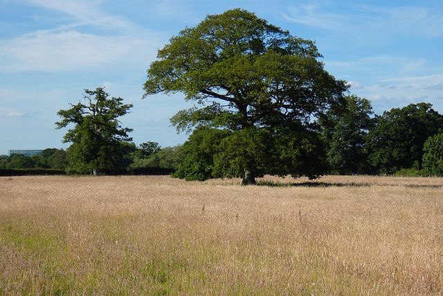
Bell Copse is a beautiful woodland area located in Berkshire, England. Situated near the village of Wargrave, it covers an area of approximately 50 acres and is a popular destination for nature enthusiasts and hikers alike.

The copse is predominantly composed of broadleaf trees, such as oak, beech, and ash, which create a dense and lush canopy overhead. The forest floor is rich with a variety of wildflowers, ferns, and moss, creating a vibrant and colorful undergrowth.

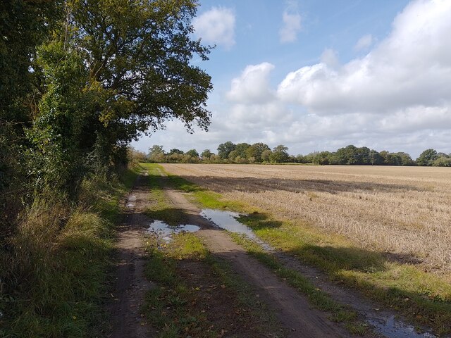
The woodland is intersected by several well-maintained footpaths, offering visitors the opportunity to explore its serene surroundings. These paths wind through the trees, leading to hidden clearings and secluded spots where one can relax and immerse themselves in nature.

Bell Copse is also home to a diverse range of wildlife. Birdwatchers can spot a variety of species, including blue tits, great tits, and nuthatches, among others. Squirrels, rabbits, and deer are frequently seen darting through the trees, adding to the copse's natural charm.

Throughout the year, Bell Copse offers a different experience with each season. In the spring, the woods come alive with the vibrant colors of bluebells and daffodils. Summer brings a lush green foliage and provides a cool and shaded retreat from the heat. In autumn, the copse is transformed into a tapestry of reds, oranges, and yellows as the leaves change, creating a picturesque scene. Winter brings a quiet and serene atmosphere, with frost-covered trees adding a touch of magic.

Overall, Bell Copse is a haven of natural beauty, offering visitors a tranquil escape from the hustle and bustle of everyday life.

If you have any feedback on the listing, please let us know in the comments section below.

Bell Copse Images

Images are sourced within 2km of 51.400923/-1.0150079 or Grid Reference SU6867. Thanks to Geograph Open Source API. All images are credited.

Pasture, Shinfield Beside the footpath to the south of Hopkiln Farm.
Pasture, Shinfield
Beside the footpath to the south of Hopkiln Farm.
Junction of Church Lane and Mortimer Road
Footpath towards Burnthouse Lane A public footpath between Kybes Lane and Burnthouse Lane.
Footpath towards Burnthouse Lane
A public footpath between Kybes Lane and Burnthouse Lane.
Grazeley Green Road at the junction of Mereoak Lane
Bridge over the Foudry Brook On the bridleway between Spencers Wood and Grazeley.
Bridge over the Foudry Brook
On the bridleway between Spencers Wood and Grazeley.
Pond near Grazeley This is beside the Foudry Brook in the middle of a field.
The pond is crescent shaped, like it might have been a moat or something, but there's nothing on the map about it.
Update from Penny Mayes :- Looking at the oldest large scale maps I think this is an ox-bow lake. Looks like a new straighter channel may have been cut for the stream to make the land more useful."
Pond near Grazeley
This is beside the Foudry Brook in the middle of a field. The pond is crescent shaped, like it might have been a moat or something, but there's nothing on the map about it. Update from Penny Mayes :- Looking at the oldest large scale maps I think this is an ox-bow lake. Looks like a new straighter channel may have been cut for the stream to make the land more useful."
Bridleway Gate, Grazeley This is a good, fit for purpose sort of gate. Solid enough to keep vehicles out but easy for horses to step over.
Bridleway Gate, Grazeley
This is a good, fit for purpose sort of gate. Solid enough to keep vehicles out but easy for horses to step over.
Near Gravelly Bridge Farm Fields and Trees along the Foudry Brook.
Near Gravelly Bridge Farm
Fields and Trees along the Foudry Brook.
At Gravelly Bridge Farm A view over flat terrain towards Reading's landmark giant turbine at Green Park beside the M4.
At Gravelly Bridge Farm
A view over flat terrain towards Reading's landmark giant turbine at Green Park beside the M4.
Field opposite Gravelly Bridge Farm
Mereoak Lane Towards Reading.
Mereoak Lane
Towards Reading.
Crops near Gravelly Bridge It appears that this crop may be broad beans?
Crops near Gravelly Bridge
It appears that this crop may be broad beans?
Former pub, Grazeley The ex-Wheatsheaf standing at the junction of Church Lane and the main road to Mortimer. Church Lane is a cul-de-sac giving access to the church, village hall and two residences. The rest of small community here, including its school, is a short distance to the south. There are separate hamlets at Poundgreen and Grazeley Green.

Given the size of the place, it isn't surprising to find that the pub is no longer, though its location on a relatively busy road may have been something of an advantage. It is presumably destined to be converted to residential use.

The building is in two distinct parts and this view chiefly shows the more modern 19th century part. Behind there is just a glimpse the 17th century part. That part has an exposed timber frame and a roof currently under a blue tarpaulin.
Former pub, Grazeley
The ex-Wheatsheaf standing at the junction of Church Lane and the main road to Mortimer. Church Lane is a cul-de-sac giving access to the church, village hall and two residences. The rest of small community here, including its school, is a short distance to the south. There are separate hamlets at Poundgreen and Grazeley Green. Given the size of the place, it isn't surprising to find that the pub is no longer, though its location on a relatively busy road may have been something of an advantage. It is presumably destined to be converted to residential use. The building is in two distinct parts and this view chiefly shows the more modern 19th century part. Behind there is just a glimpse the 17th century part. That part has an exposed timber frame and a roof currently under a blue tarpaulin.
Farmland at Hartley Court This is the first bit of open farmland south of the M4.  Most of the square is like this.  Beyond the M4 is Green Park (the tops of some of the offices can just be seen).  Oh, and the whole area is dominated by the Green Park wind turbine in <a href="https://www.geograph.org.uk/gridref/SU7069">SU7069</a>
Farmland at Hartley Court
This is the first bit of open farmland south of the M4. Most of the square is like this. Beyond the M4 is Green Park (the tops of some of the offices can just be seen). Oh, and the whole area is dominated by the Green Park wind turbine in SU7069
Farmland at Gravelly Bridge Opposite the farm is this field with a legume crop.
Farmland at Gravelly Bridge
Opposite the farm is this field with a legume crop.
Gravelly Bridge There are two houses at the road junction, this one and its better-kept neighbour to the right.
Gravelly Bridge
There are two houses at the road junction, this one and its better-kept neighbour to the right.
The Wheatsheaf, Grazeley Little has changed at this former pub in the seven months since Andrew Smith's picture <a href="https://www.geograph.org.uk/photo/996852">SU7066 : Former pub, Grazeley</a> except that various notices have gone up including an "all enquiries" board.
The Wheatsheaf, Grazeley
Little has changed at this former pub in the seven months since Andrew Smith's picture SU7066 : Former pub, Grazeley except that various notices have gone up including an "all enquiries" board.
Grazeley village hall Squeezed onto a triangle of land between the main road, the road to the church and the playing field.
Grazeley village hall
Squeezed onto a triangle of land between the main road, the road to the church and the playing field.
Show me another place!

Bell Copse is located at Grid Ref: SU6867 (Lat: 51.400923, Lng: -1.0150079)

Unitary Authority: West Berkshire

Police Authority: Thames Valley

What 3 Words

///year.when.deeply. Near Stratfield Mortimer, Berkshire

Nearby Locations

Bell Copse

Related Wikis

Wokefield

Wokefield is a hamlet and civil parish in the West Berkshire district of Berkshire, England, south of Reading. The parish includes the hamlets of Goddard...

Lockram Brook

Lockram Brook is a small stream in southern England. It rises near the Berkshire village of Mortimer, and is a tributary of Burghfield Brook. == Route... ==

Grazeley

Grazeley is an area covering the small villages of Grazeley in the civil parish of Shinfield and Grazeley Green in the civil parish of Wokefield, 4 miles...

Bloomfield Hatch

Bloomfield Hatch is a hamlet in Berkshire, England, and part of the civil parish of Wokefield . The settlement lies near the villages of Stratfield Mortimer...

Nearby Amenities

Located within 500m of 51.400923,-1.0150079
Barrier: stile
Foot: yes
Lat/Long: 51.4006453/-1.0197715
The data included in this document is from www.openstreetmap.org. The data is made available under ODbL.

Have you been to Bell Copse?

Leave your review of Bell Copse below (or comments, questions and feedback).