Hained-in Wood

Wood, Forest in Oxfordshire South Oxfordshire

England

Hained-in Wood

Remains of the Polish Village After WW2 there were a lot of displaced Polish people who needed somewhere to live. Old military buildings provided accommodation for a Polish community here up until the 1960s.
Abandoned buildings from that time can still be seen in the woods.
History on <span class="nowrap"><a title="https://www.polishresettlementcampsintheuk.co.uk/checkendon.htm" rel="nofollow ugc noopener" href="https://www.polishresettlementcampsintheuk.co.uk/checkendon.htm">Link</a><img style="margin-left:2px;" alt="External link" title="External link - shift click to open in new window" src="https://s1.geograph.org.uk/img/external.png" width="10" height="10"/></span>
Remains of the Polish Village Credit: Des Blenkinsopp

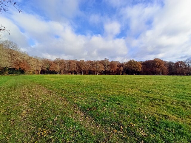
Hained-in Wood is a picturesque forest located in Oxfordshire, England. Covering an area of approximately 500 acres, this woodland is renowned for its natural beauty and rich biodiversity. The wood is situated near the charming village of Hained-in, which adds to its appeal as a popular destination for nature enthusiasts and hikers alike.

The forest is predominantly composed of deciduous trees, including oak, beech, and birch, which create a vibrant canopy during the summer months. The dense undergrowth consists of ferns, bluebells, and various wildflowers, providing a colorful and serene environment for visitors to explore.

Hained-in Wood is home to a diverse range of wildlife, making it a haven for nature lovers. Birdwatchers can spot species such as woodpeckers, buzzards, and tawny owls, while the forest floor is inhabited by badgers, foxes, and deer. The tranquil atmosphere of the wood allows visitors to observe these creatures in their natural habitat.

Several walking trails wind through the forest, offering visitors the opportunity to immerse themselves in its beauty. These paths are well-maintained and suitable for all ages and fitness levels. As visitors stroll through the wood, they can enjoy the peacefulness of nature and the harmonious sounds of chirping birds and rustling leaves.

Overall, Hained-in Wood in Oxfordshire is a place of natural wonder, offering visitors a chance to escape the hustle and bustle of everyday life and reconnect with nature. Its breathtaking scenery, diverse wildlife, and well-maintained trails make it a perfect destination for both locals and tourists to enjoy the great outdoors.

If you have any feedback on the listing, please let us know in the comments section below.

Hained-in Wood Images

Images are sourced within 2km of 51.549393/-1.0200552 or Grid Reference SU6883. Thanks to Geograph Open Source API. All images are credited.

Remains of the Polish Village After WW2 there were a lot of displaced Polish people who needed somewhere to live. Old military buildings provided accommodation for a Polish community here up until the 1960s.
Abandoned buildings from that time can still be seen in the woods.
History on <span class="nowrap"><a title="https://www.polishresettlementcampsintheuk.co.uk/checkendon.htm" rel="nofollow ugc noopener" href="https://www.polishresettlementcampsintheuk.co.uk/checkendon.htm">Link</a><img style="margin-left:2px;" alt="External link" title="External link - shift click to open in new window" src="https://s1.geograph.org.uk/img/external.png" width="10" height="10"/></span>
Remains of the Polish Village
After WW2 there were a lot of displaced Polish people who needed somewhere to live. Old military buildings provided accommodation for a Polish community here up until the 1960s. Abandoned buildings from that time can still be seen in the woods. History on LinkExternal link
Another Hut in the Woods Another one of the derelict buildings left over from WW2 which can still be seen in the woods round here. These were lived in up until the 1960s by community of Polish people displaced by the war.
History on <span class="nowrap"><a title="https://www.polishresettlementcampsintheuk.co.uk/checkendon.htm" rel="nofollow ugc noopener" href="https://www.polishresettlementcampsintheuk.co.uk/checkendon.htm">Link</a><img style="margin-left:2px;" alt="External link" title="External link - shift click to open in new window" src="https://s1.geograph.org.uk/img/external.png" width="10" height="10"/></span>
Another Hut in the Woods
Another one of the derelict buildings left over from WW2 which can still be seen in the woods round here. These were lived in up until the 1960s by community of Polish people displaced by the war. History on LinkExternal link
Fingerposts at Highmoor Cross
The road to Stoke Row Going through Bear Wood
The road to Stoke Row
Going through Bear Wood
Bear Wood, Stoke Row
Stoke Row The road becomes Kit Lane but the maps don't give a name till beyond the end of the village.
Stoke Row
The road becomes Kit Lane but the maps don't give a name till beyond the end of the village.
Stoke Row Green
Stoke Row Green
Stoke Row
Stoke Row
Houses in Stoke Row Looking towards Church View.
Houses in Stoke Row
Looking towards Church View.
Church View, Stoke Row
Kit Lane, Stoke Row
Kit Lane, Stoke Row
Basset Wood
Basset Wood
Woods north east of Stoke Row
Nott Wood
Nott Wood
The Maharajah's Well, Stoke Row This is an unlikely looking structure to find in an Oxfordshire village. Its origins lie in the friendship that developed between Edward Anderton Reade, the son of a local squire who spent his working life in India, and the Maharajah of Benares. In Victorian times the villages of this part of Oxfordshire had only limited access to clean water bringing considerable hardship to the poor of the area. Learning of these difficulties, the Maharajah - who had remained loyal to the British during the Indian Mutiny of 1857 - determined that a charity should be set up to relieve the problem. The result was a well dug to a depth of 368 feet, a considerable engineering achievement. To honour the Maharajah, who never visited Britain, a splendid well canopy was built incorporating a gold elephant representing the Hindu god Ganesh. The well was used until the beginning of the Second World War although by that time most houses in the village had a mains connection. Today the well has been renovated and preserved and is maintained by the Maharajah's Well Trust.

The octagonal cottage to the right was built to house the well warden. The last warden died in 1979 since when it has been rented out to supplement the charity's income.
The Maharajah's Well, Stoke Row
This is an unlikely looking structure to find in an Oxfordshire village. Its origins lie in the friendship that developed between Edward Anderton Reade, the son of a local squire who spent his working life in India, and the Maharajah of Benares. In Victorian times the villages of this part of Oxfordshire had only limited access to clean water bringing considerable hardship to the poor of the area. Learning of these difficulties, the Maharajah - who had remained loyal to the British during the Indian Mutiny of 1857 - determined that a charity should be set up to relieve the problem. The result was a well dug to a depth of 368 feet, a considerable engineering achievement. To honour the Maharajah, who never visited Britain, a splendid well canopy was built incorporating a gold elephant representing the Hindu god Ganesh. The well was used until the beginning of the Second World War although by that time most houses in the village had a mains connection. Today the well has been renovated and preserved and is maintained by the Maharajah's Well Trust. The octagonal cottage to the right was built to house the well warden. The last warden died in 1979 since when it has been rented out to supplement the charity's income.
The Maharajah's Well, Stoke Row This is looking under the canopy of the well where the gold elephant takes pride of place. See <a href="https://www.geograph.org.uk/photo/7620533">SU6784 : The Maharajah's Well, Stoke Row</a> for a wider view and some historical notes.
The Maharajah's Well, Stoke Row
This is looking under the canopy of the well where the gold elephant takes pride of place. See SU6784 : The Maharajah's Well, Stoke Row for a wider view and some historical notes.
1 Langtree Cottages, Checkendon, Oxfordshire 1906 by Maxwell Ayrton in Arts and Crafts style. 

(Source:Historic England)
1 Langtree Cottages, Checkendon, Oxfordshire
1906 by Maxwell Ayrton in Arts and Crafts style. (Source:Historic England)
Foundry Cottage, Checkendon, Oxfordshire C17 with C20 windows. Brick ground floor with areas of flint; timber frame to first floor, rendered panels to left, brick infill to right. Old plain tile roof; brick stacks. 2-unit plan. 2-storey, 3-window range. Central 2-panel door with C20 gabled tile porch. 2-light casement to left. 2 single-light casements to right. Three 2-light casements to first floor. Roof hipped to right. Ridge stack to right and end stack to left.

(Source:Historic England)
Foundry Cottage, Checkendon, Oxfordshire
C17 with C20 windows. Brick ground floor with areas of flint; timber frame to first floor, rendered panels to left, brick infill to right. Old plain tile roof; brick stacks. 2-unit plan. 2-storey, 3-window range. Central 2-panel door with C20 gabled tile porch. 2-light casement to left. 2 single-light casements to right. Three 2-light casements to first floor. Roof hipped to right. Ridge stack to right and end stack to left. (Source:Historic England)
Show me another place!

Hained-in Wood is located at Grid Ref: SU6883 (Lat: 51.549393, Lng: -1.0200552)

Administrative County: Oxfordshire

District: South Oxfordshire

Police Authority: Thames Valley

What 3 Words

///paid.hotel.unstated. Near Rotherfield Peppard, Oxfordshire

Related Wikis

Stoke Row

Stoke Row is a village and civil parish in the Chiltern Hills, about 5 miles (8 km) west of Henley-on-Thames in South Oxfordshire and about 9 miles (14...

Wyfold Court

Wyfold Court is a country house at Rotherfield Peppard in south Oxfordshire. It is a Grade II* listed building. By the year 2000, the estate had been converted...

Highmoor, Oxfordshire

Highmoor is a village and civil parish in the Chiltern Hills in Oxfordshire, about 4 miles (6.4 km) west of Henley-on-Thames. The parish includes the hamlet...

Bear, Oveys and Great Bottom Woods

Bear, Oveys and Great Bottom Woods is a 64.1-hectare (158-acre) biological Site of Special Scientific Interest west of Henley-on-Thames in Oxfordshire...

St Peter and St Paul, Checkendon

St Peter and St Paul is the Church of England parish church of Checkendon, a village in Oxfordshire, England. Its parish is part of the Deanery of Henley...

Checkendon

Checkendon is a village and civil parish about 6 miles (10 km) west of Henley-on-Thames in South Oxfordshire and about 9 miles (14 km) north west of Reading...

Ipsden Heath

Ipsden Heath is a 32-acre (13-hectare) woodland in the English county of Oxfordshire, within the Chiltern Area of Outstanding Natural Beauty. == References ==

Henley Rural District

Henley was a rural district in Oxfordshire, England from 1894 to 1974.It was named after the borough of Henley-on-Thames, which it surrounded on the west...

Nearby Amenities

Located within 500m of 51.549393,-1.0200552
Stoke Row
Place: village
Wikidata: Q2573220
Wikipedia: en:Stoke Row
Lat/Long: 51.5512365/-1.0207249
Created By: osmeditor2
Lat/Long: 51.5507667/-1.0153233
Created By: osmeditor2
Lat/Long: 51.5511/-1.0197833
Created By: osmeditor2
Lat/Long: 51.55113/-1.0245067
Created By: osmeditor2
Lat/Long: 51.5511333/-1.025325
Created By: osmeditor2
Lat/Long: 51.5511917/-1.0261533
Barrier: stile
Foot: yes
Lat/Long: 51.5490087/-1.0261511
Turning Circle
Turning Circle: square
Lat/Long: 51.5512984/-1.0150618
Bus Stop
Church View
Naptan AtcoCode: 340000715CHV
Naptan Bearing: S
Naptan CommonName: Church View
Naptan Indicator: o/s Bus Shelter
Naptan Landmark: Bus Shelter
Naptan NaptanCode: oxfapadw
Naptan Street: Church View
Naptan Verified: no
Source: naptan_import
Lat/Long: 51.551438/-1.0226138
Bus Stop
Church View
Naptan AtcoCode: 340000715OCV
Naptan Bearing: W
Naptan CommonName: Church View
Naptan Indicator: Opposite
Naptan Landmark: Church View
Naptan NaptanCode: oxfapadt
Naptan Street: Church View
Naptan Verified: no
Source: naptan_import
Lat/Long: 51.5510989/-1.022924
Bus Stop
The Cherry Tree PH
Bus: yes
Naptan AtcoCode: 340001672OPP
Naptan Bearing: W
Naptan CommonName: The Cherry Tree PH
Naptan Indicator: Opposite
Naptan Landmark: Opp Bus Shelter
Naptan NaptanCode: oxfgdagd
Naptan Street: Village Road
Naptan Verified: no
Public Transport: platform
Shelter: no
Source: naptan_import
Lat/Long: 51.5508194/-1.0160803
Bus Stop
The Cherry Tree PH
Bus: yes
Naptan AtcoCode: 340001672OUT
Naptan Bearing: E
Naptan CommonName: The Cherry Tree PH
Naptan Indicator: Outside
Naptan Landmark: Bus Shelter
Naptan NaptanCode: oxfgdaga
Naptan Street: Village Road
Naptan Verified: no
Public Transport: platform
Shelter: yes
Source: naptan_import
Lat/Long: 51.5507864/-1.0152558
Barrier: stile
Foot: yes
Lat/Long: 51.5484751/-1.0249866
Barrier: stile
Foot: yes
Lat/Long: 51.5483371/-1.0254667
Bench
Backrest: yes
Colour: brown
Material: wood
Seats: 4
Lat/Long: 51.550898/-1.0143532
Information: map
Tourism: information
Lat/Long: 51.5509884/-1.0167537
Barrier: stile
Foot: yes
Material: wood
Stile: stepover
Lat/Long: 51.5494192/-1.0243643
Barrier: bollard
Lat/Long: 51.5512413/-1.0212948
Bench
Lat/Long: 51.5512935/-1.0213739
Waste Basket
Lat/Long: 51.5512848/-1.0213774
Bench
Lat/Long: 51.5514249/-1.02134
Information: board
Tourism: information
Lat/Long: 51.5514293/-1.0212046
Turning Circle
Lat/Long: 51.5493118/-1.0151596
Crossing
Lat/Long: 51.550072/-1.0146864
Booth: K6
Covered: booth
Man Made: telephone_box
Note: there are plans to fit a defibrillator in this phone box and the telephone sign has been changed to Defibrillator
Lat/Long: 51.550973/-1.0167312
Information: guidepost
Tourism: information
Lat/Long: 51.5509451/-1.0167657
Bench
Lat/Long: 51.5511107/-1.0191619
Defibrillator
Defibrillator Location: outside Stoke Row Village Hall
Emergency: defibrillator
Indoor: no
Lat/Long: 51.5511161/-1.0208262
Tourism: information
Lat/Long: 51.5512209/-1.0207604
Information: guidepost
Tourism: information
Lat/Long: 51.5512306/-1.0193187
Direction: 185
Fixme: survey for panel count
Generator Method: photovoltaic
Generator Output Electricity: yes
Generator Solar Modules: 8
Generator Source: solar
Generator Type: solar_photovoltaic_panel
Location: roof
Power: generator
Lat/Long: 51.5509613/-1.0198809
Direction: 215
Fixme: survey for panel count
Generator Method: photovoltaic
Generator Output Electricity: yes
Generator Solar Modules: 10
Generator Source: solar
Generator Type: solar_photovoltaic_panel
Location: roof
Power: generator
Lat/Long: 51.5491184/-1.0186684
Direction: 185
Fixme: survey for panel count
Generator Method: photovoltaic
Generator Output Electricity: yes
Generator Solar Modules: 11
Generator Source: solar
Generator Type: solar_photovoltaic_panel
Location: roof
Power: generator
Lat/Long: 51.5503718/-1.0158802
Direction: 185
Generator Method: photovoltaic
Generator Output Electricity: yes
Generator Solar Modules: 8
Generator Source: solar
Generator Type: solar_photovoltaic_panel
Location: roof
Power: generator
Lat/Long: 51.5503859/-1.0160443
Direction: 185
Generator Method: photovoltaic
Generator Output Electricity: yes
Generator Solar Modules: 4
Generator Source: solar
Generator Type: solar_photovoltaic_panel
Location: roof
Power: generator
Lat/Long: 51.5503942/-1.0161243
Turning Circle
Turning Circle: knuckle
Lat/Long: 51.550462/-1.0150093
Direction: 270
Generator Method: photovoltaic
Generator Output Electricity: yes
Generator Solar Modules: 16
Generator Source: solar
Generator Type: solar_photovoltaic_panel
Location: roof
Power: generator
Lat/Long: 51.5493227/-1.015526
Fixme: solar panels?
Lat/Long: 51.5496908/-1.0152711
Parking
Lat/Long: 51.5510054/-1.0208232
Wooden Elephant
Artist Name: Peter Leadbeater
Artwork Type: sculpture
Material: wood
Tourism: artwork
Lat/Long: 51.5519113/-1.0197644
The Cherry Tree Inn
Description: Added extra tagging. Details as per pub
Tourism: hotel
Lat/Long: 51.5512573/-1.0161626
The data included in this document is from www.openstreetmap.org. The data is made available under ODbL.

Have you been to Hained-in Wood?

Leave your review of Hained-in Wood below (or comments, questions and feedback).