Barsby Spinney

Wood, Forest in Leicestershire Melton

England

Barsby Spinney

South Croxton, St John the Baptist
South Croxton, St John the Baptist Credit: Dave Kelly

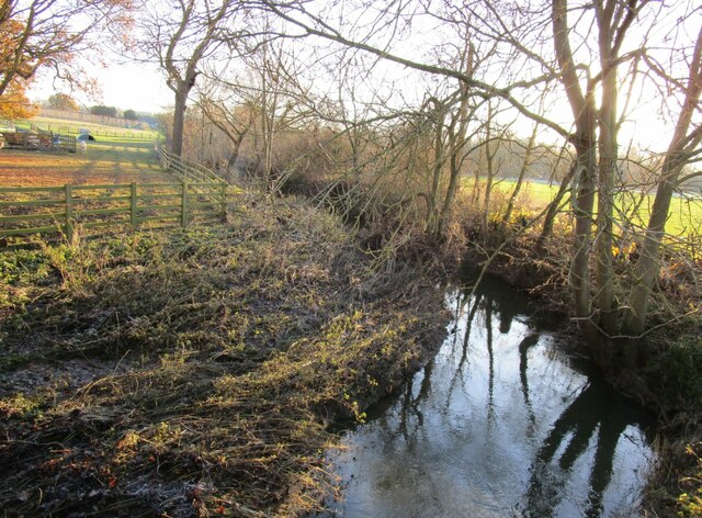
Barsby Spinney is a picturesque woodland located in Leicestershire, England. Situated in the charming village of Barsby, this woodland is a popular destination for nature lovers and outdoor enthusiasts. Spanning across a vast area, the Spinney is known for its dense and diverse vegetation, comprising a mixture of trees, shrubs, and wildflowers.

The woodland offers a tranquil and serene environment, making it an ideal spot for leisurely walks and peaceful picnics. The dense tree canopy provides shade during sunny days and creates a magical atmosphere during autumn when the leaves change color. Visitors can enjoy the soothing sound of birds chirping and the rustling of leaves as they explore the numerous walking trails that crisscross the Spinney.

Barsby Spinney is home to a variety of wildlife, including squirrels, rabbits, and numerous bird species. Lucky visitors might catch a glimpse of a deer or a fox, adding to the enchantment of the experience. The woodland is also a haven for birdwatchers, with frequent sightings of woodpeckers, owls, and various songbirds.

The Spinney is well-maintained, with clearly marked paths and benches strategically placed for those in need of a rest. It is a popular spot for families, dog walkers, and nature enthusiasts from the surrounding area. The peaceful and natural setting allows visitors to escape the hustle and bustle of everyday life, providing a much-needed respite in the heart of Leicestershire.

If you have any feedback on the listing, please let us know in the comments section below.

Barsby Spinney Images

Images are sourced within 2km of 52.699883/-0.99712904 or Grid Reference SK6711. Thanks to Geograph Open Source API. All images are credited.

South Croxton, St John the Baptist
War memorial, Gaddesby Designed by George Collin and Son. Unveiled in 1926. <span class="nowrap"><a title="https://historicengland.org.uk/listing/the-list/list-entry/1441835?section=official-list-entry" rel="nofollow ugc noopener" href="https://historicengland.org.uk/listing/the-list/list-entry/1441835?section=official-list-entry">Link</a><img style="margin-left:2px;" alt="External link" title="External link - shift click to open in new window" src="https://s1.geograph.org.uk/img/external.png" width="10" height="10"/></span>
War memorial, Gaddesby
Designed by George Collin and Son. Unveiled in 1926. LinkExternal link
The Cheney Arms, Gaddesby Dates from the late eighteenth century <span class="nowrap"><a title="https://historicengland.org.uk/listing/the-list/list-entry/1307507?section=official-list-entry" rel="nofollow ugc noopener" href="https://historicengland.org.uk/listing/the-list/list-entry/1307507?section=official-list-entry">Link</a><img style="margin-left:2px;" alt="External link" title="External link - shift click to open in new window" src="https://s1.geograph.org.uk/img/external.png" width="10" height="10"/></span>
The Cheney Arms, Gaddesby
Dates from the late eighteenth century LinkExternal link
Gaddesby Brook
Gaddesby Brook
Cream Cottage, Barsby Dates from the early eighteenth century. It once would have been thatched but now has a corrugated iron roof. <span class="nowrap"><a title="https://historicengland.org.uk/listing/the-list/list-entry/1061269?section=official-list-entry" rel="nofollow ugc noopener" href="https://historicengland.org.uk/listing/the-list/list-entry/1061269?section=official-list-entry">Link</a><img style="margin-left:2px;" alt="External link" title="External link - shift click to open in new window" src="https://s1.geograph.org.uk/img/external.png" width="10" height="10"/></span>
Cream Cottage, Barsby
Dates from the early eighteenth century. It once would have been thatched but now has a corrugated iron roof. LinkExternal link
Cottages, Gaddesby
Cottages, Gaddesby
Entrance to The Hall, Gaddesby
Footpath to the church, Gaddesby
The Hermitage, Gaddesby Late eighteenth century house <span class="nowrap"><a title="https://historicengland.org.uk/listing/the-list/list-entry/1061271?section=official-list-entry" rel="nofollow ugc noopener" href="https://historicengland.org.uk/listing/the-list/list-entry/1061271?section=official-list-entry">Link</a><img style="margin-left:2px;" alt="External link" title="External link - shift click to open in new window" src="https://s1.geograph.org.uk/img/external.png" width="10" height="10"/></span>
The Hermitage, Gaddesby
Late eighteenth century house LinkExternal link
Grass field, Gaddesby
Wisteria, Gaddesby Was once two or more houses.
Wisteria, Gaddesby
Was once two or more houses.
Church Lane, Gaddesby
14 Main Street, Barsby
Dilapidated building, Barsby Farm
Bridleway to Queniborough
Grass field off Rearsby Road Gaddesby Privet in the distance.
Grass field off Rearsby Road
Gaddesby Privet in the distance.
Tree nursery near Gaddesby
Roadway to Topfield Farm
Show me another place!

Barsby Spinney is located at Grid Ref: SK6711 (Lat: 52.699883, Lng: -0.99712904)

Administrative County: Leicestershire

District: Melton

Police Authority: Leicestershire

What 3 Words

///curated.pelt.crystal. Near Queniborough, Leicestershire

Related Wikis

South Croxton

South Croxton (traditionally pronounced "crow-sun" [ˈkroʊsən]) is a village and civil parish in the Charnwood district of Leicestershire, England. It had...

Gaddesby

Gaddesby is a village and civil parish in the Melton borough of Leicestershire, England. The population of the civil parish (including Ashby Folville and...
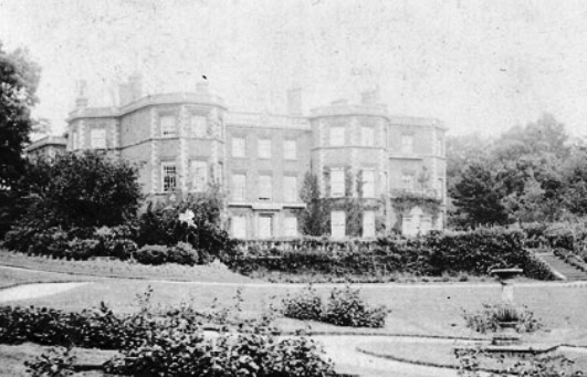
Gaddesby Hall

Gaddesby Hall is an 18th-century brick-built house in the village of Gaddesby, Leicestershire. It was built in the late 1740s as a three-storey house with...

Barsby

Barsby is a hamlet and former civil parish now in the parish of Gaddesby, in the Melton district, in the county of Leicestershire, England. In 1931 the...

Nearby Amenities

Located within 500m of 52.699883,-0.99712904
Power: tower
Source: Bing
Lat/Long: 52.6999989/-0.9983935
Power: tower
Source: Bing
Lat/Long: 52.7026872/-0.9980341
Power: tower
Source: Bing
Lat/Long: 52.6977655/-0.9987315
Power: tower
Source: Bing
Lat/Long: 52.6960848/-0.9989675
Place: farm
Lat/Long: 52.6986447/-0.9965111
Place: farm
Lat/Long: 52.6973444/-1.0030557
Power: pole
Lat/Long: 52.696131/-0.999269
Power: pole
Lat/Long: 52.6961747/-0.998747
Power: pole
Lat/Long: 52.695452/-0.9979303
Power: pole
Lat/Long: 52.6964311/-0.9985401
Power: pole
Lat/Long: 52.6958628/-0.9974783
Power: pole
Lat/Long: 52.6961584/-0.9959483
Power: pole
Lat/Long: 52.6969227/-0.9956444
Power: pole
Lat/Long: 52.6977226/-0.9953242
Power: pole
Lat/Long: 52.6985225/-0.9950171
Power: pole
Lat/Long: 52.6991699/-0.9947656
Power: pole
Lat/Long: 52.6999737/-0.9944519
Power: pole
Lat/Long: 52.7007558/-0.9941415
Power: pole
Lat/Long: 52.7015021/-0.9941513
Power: pole
Lat/Long: 52.7023812/-0.9941481
Power: pole
Lat/Long: 52.7032265/-0.9941481
The data included in this document is from www.openstreetmap.org. The data is made available under ODbL.

Have you been to Barsby Spinney?

Leave your review of Barsby Spinney below (or comments, questions and feedback).