Apes Wood

Wood, Forest in Oxfordshire South Oxfordshire

England

Apes Wood

Woodland, Checkendon Beeches to the west of Checkendon Court.
Woodland, Checkendon Credit: Andrew Smith

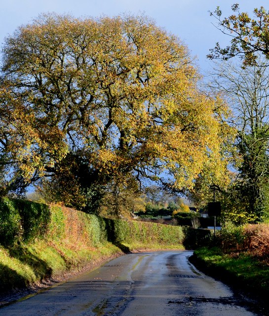
Apes Wood is a picturesque woodland located in Oxfordshire, England. Situated in the rural countryside, it covers an area of approximately 50 acres and is renowned for its natural beauty and diverse range of flora and fauna.

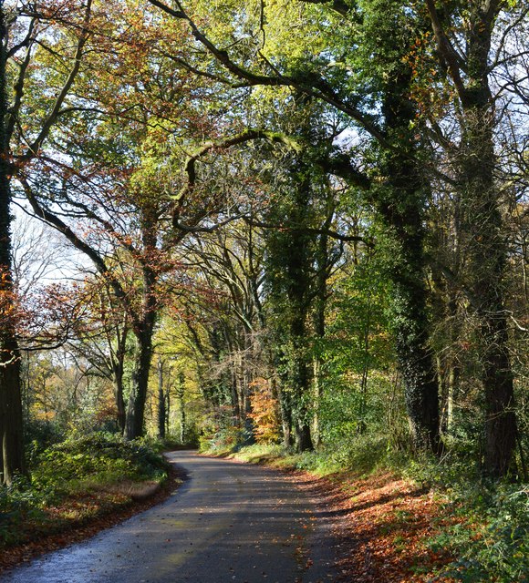
The wood is characterized by its dense canopies of tall, mature trees, predominantly oak and beech, which provide a tranquil and shaded environment. The forest floor is covered in a rich carpet of moss, ferns, and wildflowers, creating a vibrant and enchanting atmosphere.

Apes Wood is a haven for wildlife enthusiasts, as it is home to a variety of animal species. Visitors may spot deer, foxes, badgers, and a wide array of birdlife, including woodpeckers and owls. The wood's natural habitat supports a healthy ecosystem, with many species relying on the abundant resources available.

The woodland offers several walking trails that meander through its ancient trees, allowing visitors to explore its natural wonders. These paths are well-maintained and signposted, ensuring a safe and enjoyable experience for all ages.

Apes Wood is also a popular destination for nature photographers and artists, providing endless opportunities to capture the beauty of the surrounding landscape. The changing seasons create a stunning backdrop throughout the year, with vibrant autumn colors, delicate spring blossoms, and lush summer foliage.

Overall, Apes Wood is a hidden gem in Oxfordshire, offering a peaceful retreat and a chance to connect with nature. Whether it's a leisurely stroll, wildlife spotting, or simply enjoying the serenity of the wood, this natural treasure is certainly worth a visit.

If you have any feedback on the listing, please let us know in the comments section below.

Apes Wood Images

Images are sourced within 2km of 51.541009/-1.034799 or Grid Reference SU6782. Thanks to Geograph Open Source API. All images are credited.

Woodland, Checkendon Beeches to the west of Checkendon Court.
Woodland, Checkendon
Beeches to the west of Checkendon Court.
Pasture and farm buildings, Checkendon Corker's Farm viewed from the footpath passing to its west.
Pasture and farm buildings, Checkendon
Corker's Farm viewed from the footpath passing to its west.
Remains of the Polish Village After WW2 there were a lot of displaced Polish people who needed somewhere to live. Old military buildings provided accommodation for a Polish community here up until the 1960s.
Abandoned buildings from that time can still be seen in the woods.
History on <span class="nowrap"><a title="https://www.polishresettlementcampsintheuk.co.uk/checkendon.htm" rel="nofollow ugc noopener" href="https://www.polishresettlementcampsintheuk.co.uk/checkendon.htm">Link</a><img style="margin-left:2px;" alt="External link" title="External link - shift click to open in new window" src="https://s1.geograph.org.uk/img/external.png" width="10" height="10"/></span>
Remains of the Polish Village
After WW2 there were a lot of displaced Polish people who needed somewhere to live. Old military buildings provided accommodation for a Polish community here up until the 1960s. Abandoned buildings from that time can still be seen in the woods. History on LinkExternal link
Another Hut in the Woods Another one of the derelict buildings left over from WW2 which can still be seen in the woods round here. These were lived in up until the 1960s by community of Polish people displaced by the war.
History on <span class="nowrap"><a title="https://www.polishresettlementcampsintheuk.co.uk/checkendon.htm" rel="nofollow ugc noopener" href="https://www.polishresettlementcampsintheuk.co.uk/checkendon.htm">Link</a><img style="margin-left:2px;" alt="External link" title="External link - shift click to open in new window" src="https://s1.geograph.org.uk/img/external.png" width="10" height="10"/></span>
Another Hut in the Woods
Another one of the derelict buildings left over from WW2 which can still be seen in the woods round here. These were lived in up until the 1960s by community of Polish people displaced by the war. History on LinkExternal link
Stoke Row The road becomes Kit Lane but the maps don't give a name till beyond the end of the village.
Stoke Row
The road becomes Kit Lane but the maps don't give a name till beyond the end of the village.
Stoke Row Green
Stoke Row Green
Stoke Row
Stoke Row
Houses in Stoke Row Looking towards Church View.
Houses in Stoke Row
Looking towards Church View.
Church View, Stoke Row
Kit Lane, Stoke Row
Kit Lane, Stoke Row
Basset Wood
Basset Wood
The Maharajah's Well, Stoke Row This is an unlikely looking structure to find in an Oxfordshire village. Its origins lie in the friendship that developed between Edward Anderton Reade, the son of a local squire who spent his working life in India, and the Maharajah of Benares. In Victorian times the villages of this part of Oxfordshire had only limited access to clean water bringing considerable hardship to the poor of the area. Learning of these difficulties, the Maharajah - who had remained loyal to the British during the Indian Mutiny of 1857 - determined that a charity should be set up to relieve the problem. The result was a well dug to a depth of 368 feet, a considerable engineering achievement. To honour the Maharajah, who never visited Britain, a splendid well canopy was built incorporating a gold elephant representing the Hindu god Ganesh. The well was used until the beginning of the Second World War although by that time most houses in the village had a mains connection. Today the well has been renovated and preserved and is maintained by the Maharajah's Well Trust.

The octagonal cottage to the right was built to house the well warden. The last warden died in 1979 since when it has been rented out to supplement the charity's income.
The Maharajah's Well, Stoke Row
This is an unlikely looking structure to find in an Oxfordshire village. Its origins lie in the friendship that developed between Edward Anderton Reade, the son of a local squire who spent his working life in India, and the Maharajah of Benares. In Victorian times the villages of this part of Oxfordshire had only limited access to clean water bringing considerable hardship to the poor of the area. Learning of these difficulties, the Maharajah - who had remained loyal to the British during the Indian Mutiny of 1857 - determined that a charity should be set up to relieve the problem. The result was a well dug to a depth of 368 feet, a considerable engineering achievement. To honour the Maharajah, who never visited Britain, a splendid well canopy was built incorporating a gold elephant representing the Hindu god Ganesh. The well was used until the beginning of the Second World War although by that time most houses in the village had a mains connection. Today the well has been renovated and preserved and is maintained by the Maharajah's Well Trust. The octagonal cottage to the right was built to house the well warden. The last warden died in 1979 since when it has been rented out to supplement the charity's income.
The Maharajah's Well, Stoke Row This is looking under the canopy of the well where the gold elephant takes pride of place. See <a href="https://www.geograph.org.uk/photo/7620533">SU6784 : The Maharajah's Well, Stoke Row</a> for a wider view and some historical notes.
The Maharajah's Well, Stoke Row
This is looking under the canopy of the well where the gold elephant takes pride of place. See SU6784 : The Maharajah's Well, Stoke Row for a wider view and some historical notes.
1 Langtree Cottages, Checkendon, Oxfordshire 1906 by Maxwell Ayrton in Arts and Crafts style. 

(Source:Historic England)
1 Langtree Cottages, Checkendon, Oxfordshire
1906 by Maxwell Ayrton in Arts and Crafts style. (Source:Historic England)
Foundry Cottage, Checkendon, Oxfordshire C17 with C20 windows. Brick ground floor with areas of flint; timber frame to first floor, rendered panels to left, brick infill to right. Old plain tile roof; brick stacks. 2-unit plan. 2-storey, 3-window range. Central 2-panel door with C20 gabled tile porch. 2-light casement to left. 2 single-light casements to right. Three 2-light casements to first floor. Roof hipped to right. Ridge stack to right and end stack to left.

(Source:Historic England)
Foundry Cottage, Checkendon, Oxfordshire
C17 with C20 windows. Brick ground floor with areas of flint; timber frame to first floor, rendered panels to left, brick infill to right. Old plain tile roof; brick stacks. 2-unit plan. 2-storey, 3-window range. Central 2-panel door with C20 gabled tile porch. 2-light casement to left. 2 single-light casements to right. Three 2-light casements to first floor. Roof hipped to right. Ridge stack to right and end stack to left. (Source:Historic England)
Lane through the beech woods, Hook End, Oxfordshire
After rain, Stoke Row, Oxfordshire
Country lane, Ipsden, Oxfordshire
Show me another place!

Apes Wood is located at Grid Ref: SU6782 (Lat: 51.541009, Lng: -1.034799)

Administrative County: Oxfordshire

District: South Oxfordshire

Police Authority: Thames Valley

What 3 Words

///deriving.bags.receiving. Near Rotherfield Peppard, Oxfordshire

Related Wikis

St Peter and St Paul, Checkendon

St Peter and St Paul is the Church of England parish church of Checkendon, a village in Oxfordshire, England. Its parish is part of the Deanery of Henley...

Checkendon

Checkendon is a village and civil parish about 6 miles (10 km) west of Henley-on-Thames in South Oxfordshire and about 9 miles (14 km) north west of Reading...

Wyfold Court

Wyfold Court is a country house at Rotherfield Peppard in south Oxfordshire. It is a Grade II* listed building. By the year 2000, the estate had been converted...

Hook End Recording Studios

Hook End Recording Studios was a recording studio located in Hook End Manor, a 16th-century Elizabethan house near Checkendon, Oxfordshire, England. Its...

Exlade Street

Exlade Street is a hamlet in Checkendon civil parish in Oxfordshire, about 6 miles (9.7 km) northwest of Reading, in the Chiltern Hills. The hamlet is...

Stoke Row

Stoke Row is a village and civil parish in the Chiltern Hills, about 5 miles (8 km) west of Henley-on-Thames in South Oxfordshire and about 9 miles (14...

The Oratory School

The Oratory School () is an HMC co-educational private Roman Catholic boarding and day school for pupils aged 11–18 located in Woodcote, 6 miles (9.7 km...

Ipsden Heath

Ipsden Heath is a 32-acre (13-hectare) woodland in the English county of Oxfordshire, within the Chiltern Area of Outstanding Natural Beauty. == References ==

Nearby Amenities

Located within 500m of 51.541009,-1.034799
Turning Circle
Turning Circle: hammer
Lat/Long: 51.542679/-1.0393074
Barrier: kissing_gate
Foot: yes
Lat/Long: 51.5392071/-1.0321148
Barrier: kissing_gate
Foot: yes
Lat/Long: 51.5415599/-1.0333638
Barrier: kissing_gate
Foot: yes
Lat/Long: 51.5425809/-1.0362489
Barrier: kissing_gate
Foot: yes
Lat/Long: 51.5421326/-1.0389355
Barrier: kissing_gate
Foot: yes
Lat/Long: 51.5451339/-1.0374785
Barrier: kissing_gate
Foot: yes
Lat/Long: 51.5454855/-1.0349461
Fixme: solar panel?
Lat/Long: 51.544327/-1.0384648
Post Box
Operator: Royal Mail
Post Box Type: pillar
Ref: RG8 291
Royal Cypher: EIIR
Lat/Long: 51.5436063/-1.0381322
The data included in this document is from www.openstreetmap.org. The data is made available under ODbL.

Have you been to Apes Wood?

Leave your review of Apes Wood below (or comments, questions and feedback).