Aldermoor Coppice

Wood, Forest in Hampshire Winchester

England

Aldermoor Coppice

A view with birds Or maybe, birds with a view? Seagulls on the hunt for food scraps near the cafe on Portsdown Hill. The nearest water is Portsmouth Harbour and the far water is The Solent, with the Isle of Wight in the misty distance.
A view with birds Credit: David Martin

Aldermoor Coppice is a serene and picturesque woodland located in the county of Hampshire, England. Covering an area of approximately 50 acres, this ancient coppice offers visitors a tranquil retreat from the hustle and bustle of daily life.

The coppice is predominantly composed of alder trees, which thrive in the damp and fertile soil of the area. These trees create a dense and lush canopy, providing shade and shelter for a diverse range of flora and fauna. The forest floor is adorned with a carpet of bluebells during the springtime, creating a stunning natural spectacle that attracts numerous visitors.

Nature enthusiasts will be delighted to discover a thriving ecosystem within the coppice. The woodland is home to a variety of bird species, including woodpeckers, finches, and owls, which can be spotted and heard throughout the year. Squirrels and rabbits are also common inhabitants, adding a touch of liveliness to the peaceful atmosphere.

Aldermoor Coppice is a popular destination for those seeking outdoor activities. Several well-maintained walking trails meander through the woodland, allowing visitors to explore its beauty at their own pace. Additionally, the forest provides an ideal setting for picnics, photography, and nature observation.

The coppice is conveniently located near the village of Aldermoor, providing easy access for locals and tourists alike. Whether one seeks solace in nature or wishes to engage in recreational pursuits, Aldermoor Coppice offers a delightful experience for all who venture into its leafy embrace.

If you have any feedback on the listing, please let us know in the comments section below.

Aldermoor Coppice Images

Images are sourced within 2km of 50.864152/-1.0571802 or Grid Reference SU6607. Thanks to Geograph Open Source API. All images are credited.

A view with birds Or maybe, birds with a view? Seagulls on the hunt for food scraps near the cafe on Portsdown Hill. The nearest water is Portsmouth Harbour and the far water is The Solent, with the Isle of Wight in the misty distance.
A view with birds
Or maybe, birds with a view? Seagulls on the hunt for food scraps near the cafe on Portsdown Hill. The nearest water is Portsmouth Harbour and the far water is The Solent, with the Isle of Wight in the misty distance.
Harbour Heights Apartments on Portsdown Hill Road.
Harbour Heights
Apartments on Portsdown Hill Road.
Portsdown Hill, looking over Queen Alexandra Hospital The nearest water is Langstone Harbour, with Hayling Island beyond; the English Channel just appears on the misty horizon.
Portsdown Hill, looking over Queen Alexandra Hospital
The nearest water is Langstone Harbour, with Hayling Island beyond; the English Channel just appears on the misty horizon.
Ford in Pigeon House Lane
Looking down Mill Lane Narrow lane descending the dip slope of Portsdown Hill.
Looking down Mill Lane
Narrow lane descending the dip slope of Portsdown Hill.
Mill Lane, near Fort Widley There is a popular car park with burger van at the top of Mill Lane, with wide views over Portsmouth. North from there, the lane descends the dip slope of Portsdown Hill.
Mill Lane, near Fort Widley
There is a popular car park with burger van at the top of Mill Lane, with wide views over Portsmouth. North from there, the lane descends the dip slope of Portsdown Hill.
Northern end of Geoffrey Avenue There is a short cul-de-sac section beyond the point where the main route turns right into Victoria Avenue.
Northern end of Geoffrey Avenue
There is a short cul-de-sac section beyond the point where the main route turns right into Victoria Avenue.
Purbrook Heath Recreation Ground
Parade of shops on London Road
Church of St John the Baptist, Purbrook
Modern apartments beside Newlands Avenue
House on edge of new development This house in Cowdray Close borders Alsfordmoor Coppice.
House on edge of new development
This house in Cowdray Close borders Alsfordmoor Coppice.
Newly-built houses in Marrelsmoor Avenue
New-build with a 1930s feel, Ainsworth Road
Field edge north of Newlands Farm
View across footbridge into Barfoot Close
Boardwalk beside muddy pond At the moment, this pond sits isolated in the middle of extensive housing construction. It will be interesting to see how the site matures when the developers move on.
Boardwalk beside muddy pond
At the moment, this pond sits isolated in the middle of extensive housing construction. It will be interesting to see how the site matures when the developers move on.
Looking northwards from Portsdown Hill
Show me another place!

Aldermoor Coppice is located at Grid Ref: SU6607 (Lat: 50.864152, Lng: -1.0571802)

Administrative County: Hampshire

District: Winchester

Police Authority: Hampshire

What 3 Words

///town.club.looks. Near Cosham, Hampshire

Related Wikis

Purbrook Heath

Purbrook Heath is a hamlet in the civil parish of Purbrook in the Havant district of Hampshire, England. Its nearest town is Waterlooville, which lies...

Widley

Widley is an area of the Greater Portsmouth conurbation in the South East of England near Waterlooville and Purbrook. It is on the dip slope of the South...

Southwick and Widley

Southwick and Widley is a civil parish in the English county of Hampshire forming part of the area administered as the City of Winchester. It comprises...

Purbrook Park School

Purbrook Park School is a comprehensive co-educational secondary school situated in Purbrook, north of Portsmouth, Hampshire. The school has an enrollment...
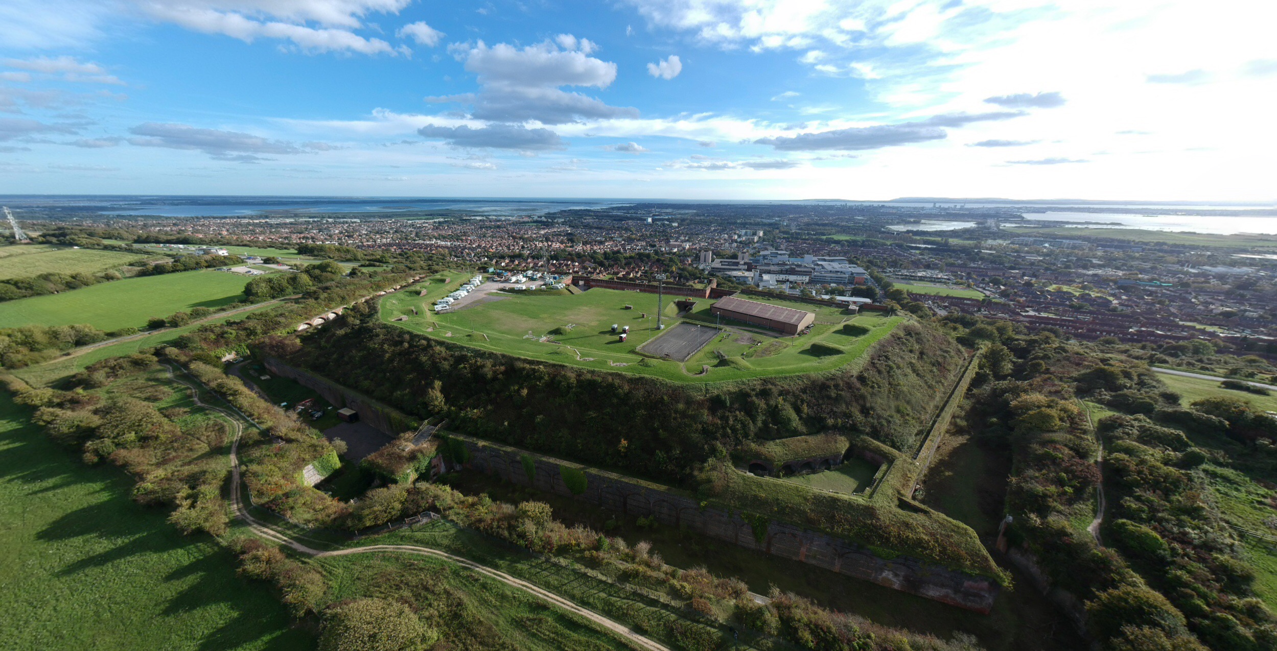
Fort Widley

Fort Widley is one of the forts built on top of Portsdown Hill between 1860 and 1868 on the recommendation of the Royal Commission on the Defence of the...

Purbrook

Purbrook is a village and local government sub-division located in Hampshire, England. Purbrook is on the outskirts of Waterlooville just north of the...

Queen Alexandra Hospital

The Queen Alexandra Hospital (commonly known as QA Hospital, QAH or simply QA) is a large NHS hospital in Portsmouth, Hampshire. Located in Cosham, it...

Crookhorn College

Crookhorn College is a coeducational foundation secondary school, located in Waterlooville in the English county of Hampshire.It is administered by Hampshire...

Nearby Amenities

Located within 500m of 50.864152,-1.0571802
Barrier: stile
Lat/Long: 50.8626551/-1.0636731
Barrier: kissing_gate
Lat/Long: 50.8651864/-1.0539059
Power: pole
Lat/Long: 50.867161/-1.0617846
Power: pole
Lat/Long: 50.8671272/-1.0619295
Power: pole
Lat/Long: 50.8650331/-1.0623935
Power: pole
Lat/Long: 50.8659304/-1.0622916
Power: pole
Lat/Long: 50.86591/-1.0624257
Power: pole
Lat/Long: 50.8651821/-1.0626966
The data included in this document is from www.openstreetmap.org. The data is made available under ODbL.

Have you been to Aldermoor Coppice?

Leave your review of Aldermoor Coppice below (or comments, questions and feedback).