The Belt

Wood, Forest in Yorkshire

England

The Belt

The View From Grimston Grange
The View From Grimston Grange Credit: DAVID JOHN SHERLOCK

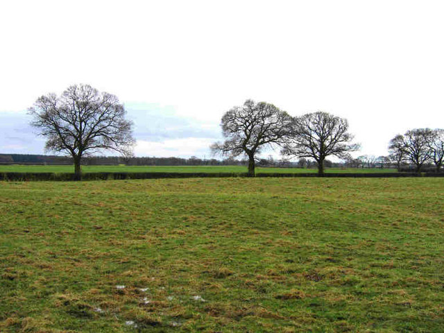
The Belt, Yorkshire, also known as Wood or Forest Belt, is a picturesque area located in the county of Yorkshire, England. Stretching across a vast expanse of land, this region is renowned for its beautiful woodlands and forests that cover the landscape.

The Belt is characterized by its diverse range of tree species, including oak, beech, birch, and pine, which create a dense and vibrant canopy. These woodlands provide a habitat for numerous wildlife species, such as deer, foxes, rabbits, and a variety of bird species, making it a haven for nature enthusiasts and birdwatchers.

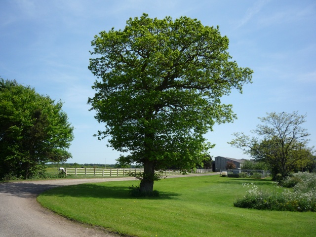
The area offers a plethora of walking and hiking trails, allowing visitors to explore the enchanting woodlands and immerse themselves in the natural beauty of the surroundings. There are also designated picnic areas and viewpoints where visitors can relax and enjoy the tranquil atmosphere.

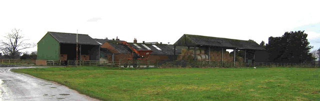
In addition to its natural charm, The Belt boasts a rich history dating back centuries. It is dotted with ancient ruins and landmarks, including old stone walls, remnants of medieval castles, and archaeological sites, offering glimpses into the area's past.

The Belt, Yorkshire, is a popular destination for outdoor activities, including camping, cycling, and horseback riding. It attracts visitors from all over the world who seek a peaceful retreat and an opportunity to reconnect with nature. With its stunning woodlands, abundant wildlife, and historical significance, The Belt is a must-visit destination for nature lovers and history enthusiasts alike.

If you have any feedback on the listing, please let us know in the comments section below.

The Belt Images

Images are sourced within 2km of 53.955432/-1.0048934 or Grid Reference SE6551. Thanks to Geograph Open Source API. All images are credited.

The View From Grimston Grange
Grimston Grange
Grimston Grange
Ox-Close Farm Calves feeding between showers on a rainy day.
Ox-Close Farm
Calves feeding between showers on a rainy day.
Grimston Grange Towards Grimston Grange from the Low Lane footpath.
Grimston Grange
Towards Grimston Grange from the Low Lane footpath.
Grimston Grange From the path through Ox Close Farm.
Grimston Grange
From the path through Ox Close Farm.
Ox Close Farm Hungry cows munching on hay outside the barn.
Ox Close Farm
Hungry cows munching on hay outside the barn.
Ox Close Lane
Ox Close Lane
Ox Close Farm on Ox Close Lane
Cattle at Ox Close Farm on Ox Close Lane
Ox Close Farm on Ox Close Lane
Ox Close Lane towards Heslington
Barn on Ox Close Lane
Ox Close Lane Looking along Ox Close Lane which leads to Ox Close and Grimston Grange Farms.
Ox Close Lane
Looking along Ox Close Lane which leads to Ox Close and Grimston Grange Farms.
Cattle at Ox Close Farm Looking along Ox Close Lane with young cattle feeding in the sunshine.
Cattle at Ox Close Farm
Looking along Ox Close Lane with young cattle feeding in the sunshine.
Cattle at Ox Close Farm Young cattle feeding beside Ox Close Lane.
Cattle at Ox Close Farm
Young cattle feeding beside Ox Close Lane.
Show me another place!

The Belt is located at Grid Ref: SE6551 (Lat: 53.955432, Lng: -1.0048934)

Division: East Riding

Unitary Authority: York

Police Authority: North Yorkshire

What 3 Words

///organ.quite.keys. Near Murton, North Yorkshire

Related Wikis

Grimston, York

Grimston is a hamlet in the civil parish of Dunnington, in the York district, in the ceremonial county of North Yorkshire, England. It is 3 miles east...

Yorkshire Museum of Farming

The Yorkshire Museum of Farming is located in Murton Park near York in England. It is housed on a grass field site of approximately 14 acres (5.7 ha),...

Murton Lane railway station

Murton Lane railway station served the village of Murton in the City of York, part of the Ceremonial County of North Yorkshire, from 1913 to 1926 on the...

Derwent Valley Light Railway

The Derwent Valley Light Railway (DVLR) (also known as The Blackberry Line) was a privately owned standard-gauge railway in North Yorkshire, England, and...

Nearby Amenities

Located within 500m of 53.955432,-1.0048934
Crossing
Bicycle: yes
Crossing Island: yes
Lat/Long: 53.9591761/-1.0056002
Traffic Signals
Crossing: no
Lat/Long: 53.9574898/-1.0015225
Crossing
Bicycle: yes
Crossing: uncontrolled
Lat/Long: 53.9564889/-1.0088926
Crossing
Bicycle: yes
Crossing: uncontrolled
Tactile Paving: no
Lat/Long: 53.9575848/-1.0113562
Crossing
Bicycle: yes
Crossing: uncontrolled
Lat/Long: 53.9562279/-1.0107946
Crossing
Bicycle: yes
Crossing: uncontrolled
Lat/Long: 53.9574651/-1.0102305
Crossing
Crossing: unmarked
Crossing Markings: no
Tactile Paving: yes
Lat/Long: 53.9566647/-1.008712
Crossing
Crossing: uncontrolled
Tactile Paving: yes
Lat/Long: 53.956773/-1.0088303
Parking
Parking: layby
Lat/Long: 53.9587022/-1.0070046
Traffic Signals
Crossing: no
Lat/Long: 53.9574916/-1.0113989
Crossing
Crossing: uncontrolled
Lat/Long: 53.9575428/-1.0103768
Post Box
Post Box Type: lamp
Ref: YO19 487
Royal Cypher: EIIR
Royal Cypher Wikidata: Q33102113
Lat/Long: 53.9575564/-1.0047011
York Powder Coater
Shop: powdercoater
Lat/Long: 53.9598082/-1.0054421
Junk & Jewels Warehouse
Shop: gift
Lat/Long: 53.9597546/-1.0053885
Traffic Signals
Crossing: no
Lat/Long: 53.9567106/-1.0092781
Turning Circle
Lat/Long: 53.9547393/-1.0078213
Traffic Signals
Crossing: no
Lat/Long: 53.9566751/-1.0101087
Give Way
Lat/Long: 53.9573037/-1.0102568
Grimston
Place: hamlet
Lat/Long: 53.9546174/-1.0068039
Crossing
Crossing: unmarked
Crossing Markings: no
Kerb: lowered
Tactile Paving: no
Lat/Long: 53.9589244/-1.006182
Traffic Signals
Crossing: no
Traffic Signals Direction: forward
Lat/Long: 53.9573686/-1.0014537
Traffic Signals
Crossing: no
Traffic Signals Direction: backward
Lat/Long: 53.9573757/-1.0017662
Traffic Signals
Crossing: no
Lat/Long: 53.9566695/-1.008638
Traffic Signals
Crossing: no
Traffic Signals Direction: backward
Lat/Long: 53.9564394/-1.0088231
Traffic Signals
Crossing: no
Lat/Long: 53.9576049/-1.0114087
Traffic Signals
Crossing: no
Lat/Long: 53.9565854/-1.0100093
Information: guidepost
Tourism: information
Lat/Long: 53.9584363/-0.9996969
Information: guidepost
Tourism: information
Lat/Long: 53.9588821/-1.0062442
Information: guidepost
Tourism: information
Lat/Long: 53.9592592/-1.005705
Information: route_marker
Tourism: information
Lat/Long: 53.9573196/-1.0040889
Direction North: York 4, Osbaldwick 2.25
Information: guidepost
Tourism: information
Lat/Long: 53.9573109/-1.0044992
Information: route_marker
Tourism: information
Lat/Long: 53.9581049/-1.0005942
Bus Stop
Grimston Court
Bus: yes
Departures Board: no
Public Transport: platform
Shelter: no
Lat/Long: 53.9572628/-1.0043977
Bus Stop
Grimston Court
Bus: yes
Departures Board: no
Public Transport: platform
Shelter: no
Lat/Long: 53.9571572/-1.0043782
The data included in this document is from www.openstreetmap.org. The data is made available under ODbL.

Have you been to The Belt?

Leave your review of The Belt below (or comments, questions and feedback).