Brickyard Plantation

Wood, Forest in Nottinghamshire Rushcliffe

England

Brickyard Plantation
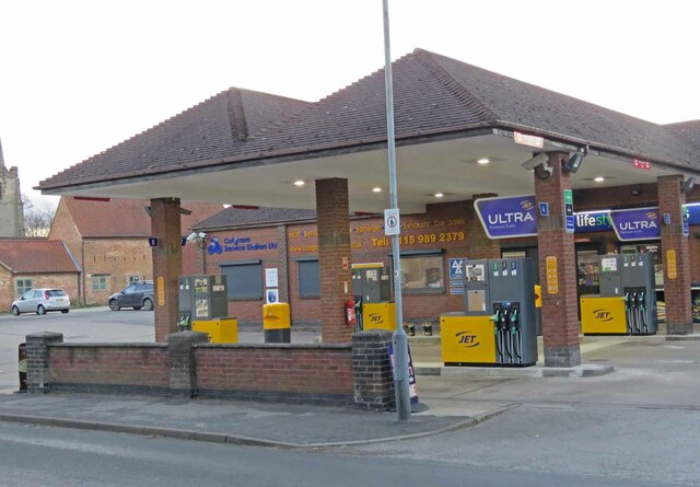
Cotgrave Service Station fuel pumps JET garage in the middle of Cotgrave.
Cotgrave Service Station fuel pumps Credit: Andrew Tatlow

Brickyard Plantation is a picturesque woodland located in Nottinghamshire, England. Situated in the heart of the county, this woodland encompasses an area of approximately 200 acres, making it an ideal destination for nature enthusiasts and outdoor enthusiasts alike.

The plantation is characterized by its dense forests, which are primarily composed of oak, beech, and birch trees. These tall, majestic trees create a vibrant and diverse ecosystem, providing habitat to a variety of wildlife species. The woodland is home to a range of bird species, including woodpeckers, owls, and songbirds, making it a haven for birdwatchers.

In addition to its natural beauty, Brickyard Plantation also boasts a rich history. The site was once used as a brickworks, hence its name, and remnants of the industrial past can still be seen within the woodland. Visitors can explore the old brick kilns and learn about the area's industrial heritage.

Today, Brickyard Plantation is a popular destination for outdoor activities. The woodland offers numerous walking trails and hiking paths, allowing visitors to immerse themselves in nature and enjoy the peaceful surroundings. The plantation is also equipped with picnic areas, making it an ideal spot for families and friends to relax and enjoy a leisurely lunch.

Overall, Brickyard Plantation in Nottinghamshire is a hidden gem, offering a blend of natural beauty and historical significance. Whether one seeks tranquility, wildlife spotting, or a glimpse into the past, this woodland provides a memorable experience for all who visit.

If you have any feedback on the listing, please let us know in the comments section below.

Brickyard Plantation Images

Images are sourced within 2km of 52.902727/-1.0447568 or Grid Reference SK6434. Thanks to Geograph Open Source API. All images are credited.

Cotgrave Service Station fuel pumps JET garage in the middle of Cotgrave.
Cotgrave Service Station fuel pumps
JET garage in the middle of Cotgrave.
Sewage pumping station, Hollygate, Cotgrave Reinforced grass access for sludge tankers.
Sewage pumping station, Hollygate, Cotgrave
Reinforced grass access for sludge tankers.
Cotgrave Country Park, Dog Toileting Area Close to the Hollygate Road car park. The notice comments that most mess is left close to the car park so dog walkers are encouraged to use this area.
Cotgrave Country Park, Dog Toileting Area
Close to the Hollygate Road car park. The notice comments that most mess is left close to the car park so dog walkers are encouraged to use this area.
Grantham Canal, Cotgrave View west at Hollygate Bridge.
Grantham Canal, Cotgrave
View west at Hollygate Bridge.
Hollygate Industrial Park The pseudo-telephone kiosk makes a suitably eye-catching sign for a firm specialising in printed display materials.
Hollygate Industrial Park
The pseudo-telephone kiosk makes a suitably eye-catching sign for a firm specialising in printed display materials.
Bridleway near Cotgrave This field and its neighbours were due at the time to be developed for new housing as part of the major expansion of Cotgrave. The bridleway route is planned to be retained as such.
Bridleway near Cotgrave
This field and its neighbours were due at the time to be developed for new housing as part of the major expansion of Cotgrave. The bridleway route is planned to be retained as such.
Colston Gate, Cotgrave The boundary of the village looking towards Colston Bassett.
Colston Gate, Cotgrave
The boundary of the village looking towards Colston Bassett.
Cotgrave village sign Cotgrave uses a number of different designs for its signs. This one displays the mining monument of Cotgrave Green <a title="https://www.geograph.org.uk/photo/2635770" href="https://www.geograph.org.uk/photo/2635770">Link</a>
Cotgrave village sign
Cotgrave uses a number of different designs for its signs. This one displays the mining monument of Cotgrave Green Link
Oil Seed Rape at Cotgrave Recreating this 'First' for the square <a title="https://www.geograph.org.uk/photo/161541" href="https://www.geograph.org.uk/photo/161541">Link</a> complete with original title, although the time of year means that one has to imagine the crop itself!
Oil Seed Rape at Cotgrave
Recreating this 'First' for the square Link complete with original title, although the time of year means that one has to imagine the crop itself!
The Cotgrave Hub A brand new (2019) development in the centre of Cotgrave including library, police station, council offices and health centre. An excellent concentration of local services at the heart of the community.
The Cotgrave Hub
A brand new (2019) development in the centre of Cotgrave including library, police station, council offices and health centre. An excellent concentration of local services at the heart of the community.
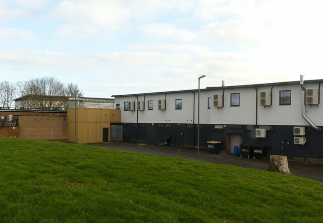
Rivermead shopping centre, Cotgrave The rear side of <a title="https://www.geograph.org.uk/photo/2635786" href="https://www.geograph.org.uk/photo/2635786">Link</a>
Rivermead shopping centre, Cotgrave
The rear side of Link
Electric car charging points In the car park at Rivermead shopping centre. The fact that the view was taken on a Sunday may explain the lack of customers.
Electric car charging points
In the car park at Rivermead shopping centre. The fact that the view was taken on a Sunday may explain the lack of customers.
Acacia House, Bingham Road, Cotgrave A typical late 18th century house with coped gables with kneelers, Listed Grade II.
Acacia House, Bingham Road, Cotgrave
A typical late 18th century house with coped gables with kneelers, Listed Grade II.
2 Main Road, Cotgrave Early 19th century 3-bay house attached to an earlier – late 18th century – former farmhouse. Now a single dwelling. Listed Grade II.
2 Main Road, Cotgrave
Early 19th century 3-bay house attached to an earlier – late 18th century – former farmhouse. Now a single dwelling. Listed Grade II.
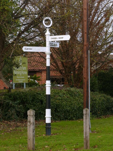
Fingerpost, Cotgrave Cross A traditional Notts CC cast iron fingerpost with annulus finial, cast by Stanton. The fingers are modern replacements in cast aluminium. An update on my 2014 view <a title="https://www.geograph.org.uk/photo/3958216" href="https://www.geograph.org.uk/photo/3958216">Link</a> – still looking smart.
Fingerpost, Cotgrave Cross
A traditional Notts CC cast iron fingerpost with annulus finial, cast by Stanton. The fingers are modern replacements in cast aluminium. An update on my 2014 view Link – still looking smart.
Church of All Saints, Cotgrave The chancel, principally 15th century, but with windows and door added as part of the restoration in 1877-8. Listed Grade I.
Church of All Saints, Cotgrave
The chancel, principally 15th century, but with windows and door added as part of the restoration in 1877-8. Listed Grade I.
Church of All Saints, Cotgrave South aisle (14th century Decorated) with 15th century tower and spire. The clock on the east face of the tower faces the village. Listed Grade I.
Church of All Saints, Cotgrave
South aisle (14th century Decorated) with 15th century tower and spire. The clock on the east face of the tower faces the village. Listed Grade I.
Church of All Saints, Cotgrave View from the south west. The west wall of the south aisle is the oldest part of the exterior fabric of the church, dating from the 13th century with a single small lancet window. Listed Grade I.
Church of All Saints, Cotgrave
View from the south west. The west wall of the south aisle is the oldest part of the exterior fabric of the church, dating from the 13th century with a single small lancet window. Listed Grade I.
Show me another place!

Brickyard Plantation is located at Grid Ref: SK6434 (Lat: 52.902727, Lng: -1.0447568)

Administrative County: Nottinghamshire

District: Rushcliffe

Police Authority: Nottinghamshire

What 3 Words

///browsers.breeding.reach. Near Cotgrave, Nottinghamshire

Related Wikis

Rushcliffe

Rushcliffe is a local government district with borough status in south Nottinghamshire, England. Its council is based in West Bridgford. The borough also...

Clipston, Nottinghamshire

Clipston, or Clipston on the Wolds, is a small English village and civil parish in the south Nottinghamshire district of Rushcliffe. It lies between Cotgrave...

All Saints' Church, Cotgrave

All Saints’ Church is a Grade I listed Church of England parish church in the Diocese of Southwell and Nottingham in Cotgrave. == History == The church...

Cotgrave

Cotgrave () is a town and civil parish in the borough of Rushcliffe in Nottinghamshire, England, some 5 miles (8 km) south-east of central Nottingham....

Normanton-on-the-Wolds

Normanton-on-the-Wolds is a small village in Nottinghamshire, England. Population in 2011 was 245. Acreage 1053. == Overview == The name "Normanton" (Norwegian...

St Hugh's College, Tollerton

St Hugh's College (also referred to as Tollerton Hall and Roclaveston Manor) was a Roman Catholic minor seminary in Tollerton founded by the Diocese of...

Owthorpe

Owthorpe is a small English village and civil parish in the Wolds of the East Midland county of Nottinghamshire. The population of about 90 was included...

St Peter's Church, Tollerton

St. Peter's Church is a Grade-II listed church located in Tollerton, Nottinghamshire, England. == History == There has been a church in Tollerton since...

Nearby Amenities

Located within 500m of 52.902727,-1.0447568
Turning Circle
Lat/Long: 52.9069704/-1.0446074
Turning Circle
Lat/Long: 52.9059131/-1.0429475
Gripps Common
Naptan AtcoCode: 3300RU0854
Naptan Bearing: SE
Naptan BusStopType: CUS
Naptan CommonName: Gripps Common
Naptan Crossing: Gripps Common
Naptan Indicator: adj
Naptan NaptanCode: ntsgtdag
Naptan Notes: CUS
Naptan Street: Owthorpe Road
Naptan Verified: no
Source: naptan_import
Lat/Long: 52.9038803/-1.0380702
Gripps Common
Naptan AtcoCode: 3300RU0855
Naptan Bearing: NW
Naptan BusStopType: CUS
Naptan CommonName: Gripps Common
Naptan Crossing: Gripps Common
Naptan Indicator: opp
Naptan NaptanCode: ntsgtdaj
Naptan Notes: CUS
Naptan Street: Owthorpe Road
Naptan Verified: no
Source: naptan_import
Lat/Long: 52.9038632/-1.0381746
Post Box
Collection Times: Mo-Fr 16:00; Sa 10:00
Post Box Design: type_k
Post Box Type: pillar
Ref: NG12 110
Royal Cypher: EIIR
Royal Cypher Wikidata: Q33102113
Source: survey
Lat/Long: 52.9057853/-1.0436742
Power: substation
Lat/Long: 52.9060237/-1.0435649
Generator Method: photovoltaic
Generator Output Electricity: yes
Generator Place: roof
Generator Source: solar
Generator Type: solar_photovoltaic_panel
Power: generator
Lat/Long: 52.9042124/-1.0378798
Generator Method: photovoltaic
Generator Orientation: S
Generator Output Electricity: yes
Generator Source: solar
Generator Type: solar_photovoltaic_panel
Location: roof
Power: generator
Lat/Long: 52.9055182/-1.0397394
Generator Method: photovoltaic
Generator Orientation: S
Generator Output Electricity: yes
Generator Source: solar
Generator Type: solar_photovoltaic_panel
Location: roof
Power: generator
Lat/Long: 52.9049513/-1.0407451
Generator Method: photovoltaic
Generator Orientation: S
Generator Output Electricity: yes
Generator Source: solar
Generator Type: solar_photovoltaic_panel
Location: roof
Power: generator
Lat/Long: 52.9047987/-1.0439481
Generator Method: photovoltaic
Generator Orientation: S
Generator Output Electricity: yes
Generator Source: solar
Generator Type: solar_photovoltaic_panel
Location: roof
Power: generator
Lat/Long: 52.9042093/-1.0415673
Generator Method: photovoltaic
Generator Orientation: S
Generator Output Electricity: yes
Generator Source: solar
Generator Type: solar_photovoltaic_panel
Location: roof
Power: generator
Lat/Long: 52.9049606/-1.040194
Generator Method: photovoltaic
Generator Orientation: S
Generator Output Electricity: yes
Generator Source: solar
Generator Type: solar_photovoltaic_panel
Location: roof
Power: generator
Lat/Long: 52.9043823/-1.0444226
Generator Method: photovoltaic
Generator Orientation: S
Generator Output Electricity: yes
Generator Source: solar
Generator Type: solar_photovoltaic_panel
Location: roof
Power: generator
Lat/Long: 52.905264/-1.0416752
Generator Method: photovoltaic
Generator Orientation: S
Generator Output Electricity: yes
Generator Source: solar
Generator Type: solar_photovoltaic_panel
Location: roof
Power: generator
Lat/Long: 52.9058466/-1.0419882
Generator Method: photovoltaic
Generator Orientation: S
Generator Output Electricity: yes
Generator Source: solar
Generator Type: solar_photovoltaic_panel
Location: roof
Power: generator
Lat/Long: 52.9042943/-1.0427011
Generator Method: photovoltaic
Generator Orientation: S
Generator Output Electricity: yes
Generator Source: solar
Generator Type: solar_photovoltaic_panel
Location: roof
Power: generator
Lat/Long: 52.9055334/-1.0396475
Generator Method: photovoltaic
Generator Orientation: S
Generator Output Electricity: yes
Generator Source: solar
Generator Type: solar_photovoltaic_panel
Location: roof
Power: generator
Lat/Long: 52.9053637/-1.0412822
Generator Method: photovoltaic
Generator Orientation: S
Generator Output Electricity: yes
Generator Source: solar
Generator Type: solar_photovoltaic_panel
Location: roof
Power: generator
Lat/Long: 52.9040827/-1.0431357
Generator Method: photovoltaic
Generator Orientation: S
Generator Output Electricity: yes
Generator Source: solar
Generator Type: solar_photovoltaic_panel
Location: roof
Power: generator
Lat/Long: 52.904531/-1.0439072
Generator Method: photovoltaic
Generator Orientation: S
Generator Output Electricity: yes
Generator Source: solar
Generator Type: solar_photovoltaic_panel
Location: roof
Power: generator
Lat/Long: 52.9058201/-1.0420822
Generator Method: photovoltaic
Generator Orientation: S
Generator Output Electricity: yes
Generator Source: solar
Generator Type: solar_photovoltaic_panel
Location: roof
Power: generator
Lat/Long: 52.905038/-1.0415098
Generator Method: photovoltaic
Generator Orientation: S
Generator Output Electricity: yes
Generator Source: solar
Generator Type: solar_photovoltaic_panel
Location: roof
Power: generator
Lat/Long: 52.9038872/-1.0430754
Generator Method: photovoltaic
Generator Orientation: S
Generator Output Electricity: yes
Generator Source: solar
Generator Type: solar_photovoltaic_panel
Location: roof
Power: generator
Lat/Long: 52.9063271/-1.0415293
Generator Method: photovoltaic
Generator Output Electricity: yes
Generator Source: solar
Generator Type: solar_photovoltaic_panel
Location: roof
Power: generator
Lat/Long: 52.9047706/-1.0413701
Generator Method: photovoltaic
Generator Orientation: S
Generator Output Electricity: yes
Generator Source: solar
Generator Type: solar_photovoltaic_panel
Location: roof
Power: generator
Lat/Long: 52.9066349/-1.0439359
Generator Method: photovoltaic
Generator Orientation: S
Generator Output Electricity: yes
Generator Source: solar
Generator Type: solar_photovoltaic_panel
Location: roof
Power: generator
Lat/Long: 52.9049875/-1.0417363
Generator Method: photovoltaic
Generator Orientation: S
Generator Output Electricity: yes
Generator Source: solar
Generator Type: solar_photovoltaic_panel
Location: roof
Power: generator
Lat/Long: 52.904931/-1.0402574
Generator Method: photovoltaic
Generator Output Electricity: yes
Generator Source: solar
Generator Type: solar_photovoltaic_panel
Location: roof
Power: generator
Lat/Long: 52.9050111/-1.0449832
Generator Method: photovoltaic
Generator Output Electricity: yes
Generator Source: solar
Generator Type: solar_photovoltaic_panel
Location: roof
Power: generator
Lat/Long: 52.9050191/-1.0441678
Generator Method: photovoltaic
Generator Output Electricity: yes
Generator Source: solar
Generator Type: solar_photovoltaic_panel
Location: roof
Power: generator
Lat/Long: 52.9048525/-1.0436716
Generator Method: photovoltaic
Generator Output Electricity: yes
Generator Source: solar
Generator Type: solar_photovoltaic_panel
Location: roof
Power: generator
Lat/Long: 52.9050741/-1.0435617
Generator Method: photovoltaic
Generator Output Electricity: yes
Generator Source: solar
Generator Type: solar_photovoltaic_panel
Location: roof
Power: generator
Lat/Long: 52.9050434/-1.0413864
Generator Method: photovoltaic
Generator Output Electricity: yes
Generator Source: solar
Generator Type: solar_photovoltaic_panel
Location: roof
Power: generator
Lat/Long: 52.9051842/-1.0419228
Generator Method: photovoltaic
Generator Output Electricity: yes
Generator Source: solar
Generator Type: solar_photovoltaic_panel
Location: roof
Power: generator
Lat/Long: 52.9052812/-1.0415446
Generator Method: photovoltaic
Generator Output Electricity: yes
Generator Source: solar
Generator Type: solar_photovoltaic_panel
Location: roof
Power: generator
Lat/Long: 52.9046673/-1.039816
Generator Method: photovoltaic
Generator Output Electricity: yes
Generator Source: solar
Generator Type: solar_photovoltaic_panel
Location: roof
Power: generator
Lat/Long: 52.9045531/-1.0410914
Generator Method: photovoltaic
Generator Output Electricity: yes
Generator Source: solar
Generator Type: solar_photovoltaic_panel
Location: roof
Power: generator
Lat/Long: 52.9058198/-1.0440123
The data included in this document is from www.openstreetmap.org. The data is made available under ODbL.

Have you been to Brickyard Plantation?

Leave your review of Brickyard Plantation below (or comments, questions and feedback).