Dunmore

Settlement in Stirlingshire

Scotland

Dunmore

National Cycle Route 76, near Lookaboutye Looking north, with Ochils framing the background
National Cycle Route 76, near Lookaboutye Credit: Euan Nelson

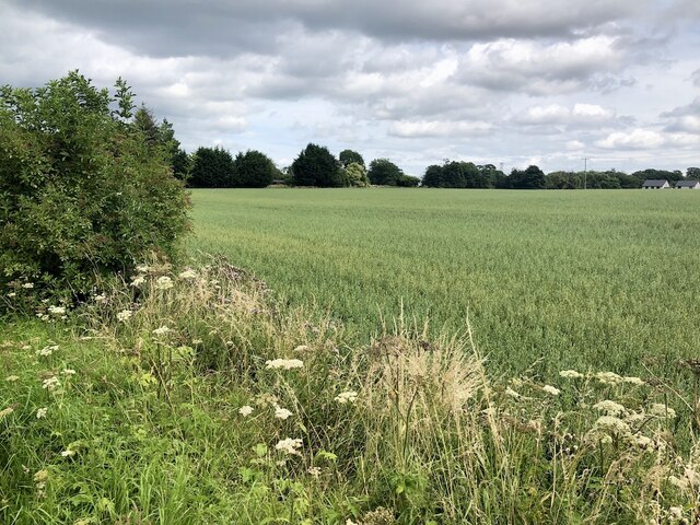
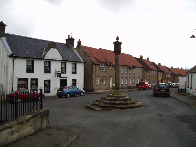
Dunmore is a small village located in Stirlingshire, Scotland. Situated in the central part of the country, it lies approximately 10 miles east of the city of Stirling. The village is nestled in a picturesque setting, surrounded by lush green fields and rolling hills.

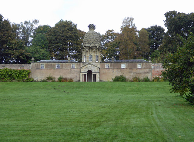
Dunmore is known for its rich historical heritage, with several notable landmarks and attractions. One of the most prominent features is Dunmore Pineapple, an iconic architectural structure built in the 18th century. This unusual building, shaped like a pineapple, was originally used as a summerhouse and is now a popular tourist attraction.

The village is also home to Dunmore Park, a stunning country estate that dates back to the 19th century. The estate boasts beautiful gardens, woodlands, and a large lake, providing a tranquil and scenic environment for visitors to explore.

In terms of amenities, Dunmore has a small number of shops, a primary school, and a community center. The village benefits from its close proximity to Stirling, where residents can access a wider range of services and facilities.

Dunmore offers a peaceful and idyllic lifestyle, making it an attractive place to live for those seeking a quieter rural setting. The surrounding countryside provides ample opportunities for outdoor activities such as hiking, cycling, and fishing.

Overall, Dunmore is a charming village with a rich history and natural beauty, offering a peaceful retreat for residents and visitors alike.

If you have any feedback on the listing, please let us know in the comments section below.

Dunmore Images

Images are sourced within 2km of 56.084688/-3.780092 or Grid Reference NS8989. Thanks to Geograph Open Source API. All images are credited.

National Cycle Route 76, near Lookaboutye Looking north, with Ochils framing the background
National Cycle Route 76, near Lookaboutye
Looking north, with Ochils framing the background
Field on the edge of Airth Oats.
Field on the edge of Airth
Oats.
Pylons towards Alloa I think that's the glass factory at the end of the line of pylons. Dumyat in the background.
Pylons towards Alloa
I think that's the glass factory at the end of the line of pylons. Dumyat in the background.
The Black Devon Near where it enters the Forth, the chimneys of Alloa glass works can be seen in the distance. <a href="https://www.geograph.org.uk/photo/340188">NS8991 : The Black Devon</a>
The Black Devon
Near where it enters the Forth, the chimneys of Alloa glass works can be seen in the distance. NS8991 : The Black Devon
Derelict  building To the west of Park Farm.
Derelict building
To the west of Park Farm.
Derelict  building Situated at a bend in The Black Devon river this building has been neglected for some time. The view is towards Clackmannan. <a href="https://www.geograph.org.uk/photo/340218">NS9090 : Derelict  building</a>
Derelict building
Situated at a bend in The Black Devon river this building has been neglected for some time. The view is towards Clackmannan. NS9090 : Derelict building
Ploughed field and pylons A view eastwards to Kincardine, and Longannet Power Station.
Ploughed field and pylons
A view eastwards to Kincardine, and Longannet Power Station.
Farm track Access to land in the vicinity of Dunmore Home Farm. The hill in the picture is called Dumyat (pronounced dim-EYE-at)
Farm track
Access to land in the vicinity of Dunmore Home Farm. The hill in the picture is called Dumyat (pronounced dim-EYE-at)
River bank This is the west bank of the Forth near Dunmore, looking towards South Alloa.
River bank
This is the west bank of the Forth near Dunmore, looking towards South Alloa.
Farm This is Dunmore Home Farm viewed from the track to Dunmore.
Farm
This is Dunmore Home Farm viewed from the track to Dunmore.
River bank A view across the Forth towards Clackmannan Tower.  <a href="https://www.geograph.org.uk/photo/157630">NS9091 : Clackmannan Tower from the East.</a>
River bank
A view across the Forth towards Clackmannan Tower. NS9091 : Clackmannan Tower from the East.
Arable land, Inch of Ferryton Stubble beneath powerlines on carse land beside the Forth.
Arable land, Inch of Ferryton
Stubble beneath powerlines on carse land beside the Forth.
Farmland near Clackmannan Recently harvested farmland near Clackmannan, with Dumyat in the Ochil Hills forming the background to the image.
Farmland near Clackmannan
Recently harvested farmland near Clackmannan, with Dumyat in the Ochil Hills forming the background to the image.
The Black Devon The Black Devon, viewed approximately one kilometre before its confluence with the Forth. This section of the river is tidal, and mudflats line the river bank.
The Black Devon
The Black Devon, viewed approximately one kilometre before its confluence with the Forth. This section of the river is tidal, and mudflats line the river bank.
Bungalow on Lookaboutye Brae
Road leading to Inch of Ferryton Taken from Lookaboutye Brae.
Road leading to Inch of Ferryton
Taken from Lookaboutye Brae.
The Pineapple, Dunmore Now a holiday let. I heard about this over 30 years ago but this was my first visit and it didn't disappoint.
The Pineapple, Dunmore
Now a holiday let. I heard about this over 30 years ago but this was my first visit and it didn't disappoint.
Stubble, Kerrie Arable land south of the Forth. Taken from the road which, like so many nowadays was closed.
Stubble, Kerrie
Arable land south of the Forth. Taken from the road which, like so many nowadays was closed.
Show me another place!

Dunmore is located at Grid Ref: NS8989 (Lat: 56.084688, Lng: -3.780092)

Unitary Authority: Falkirk

Police Authority: Forth Valley

What 3 Words

///yell.roadways.poker. Near Airth, Falkirk

Nearby Locations

Dunmore

Related Wikis

Dunmore, Falkirk

Dunmore is a small village in the Falkirk council area of Scotland. It lies 6.5 miles (10.5 km) south east of Stirling and 5.5 miles (8.9 km) north of...

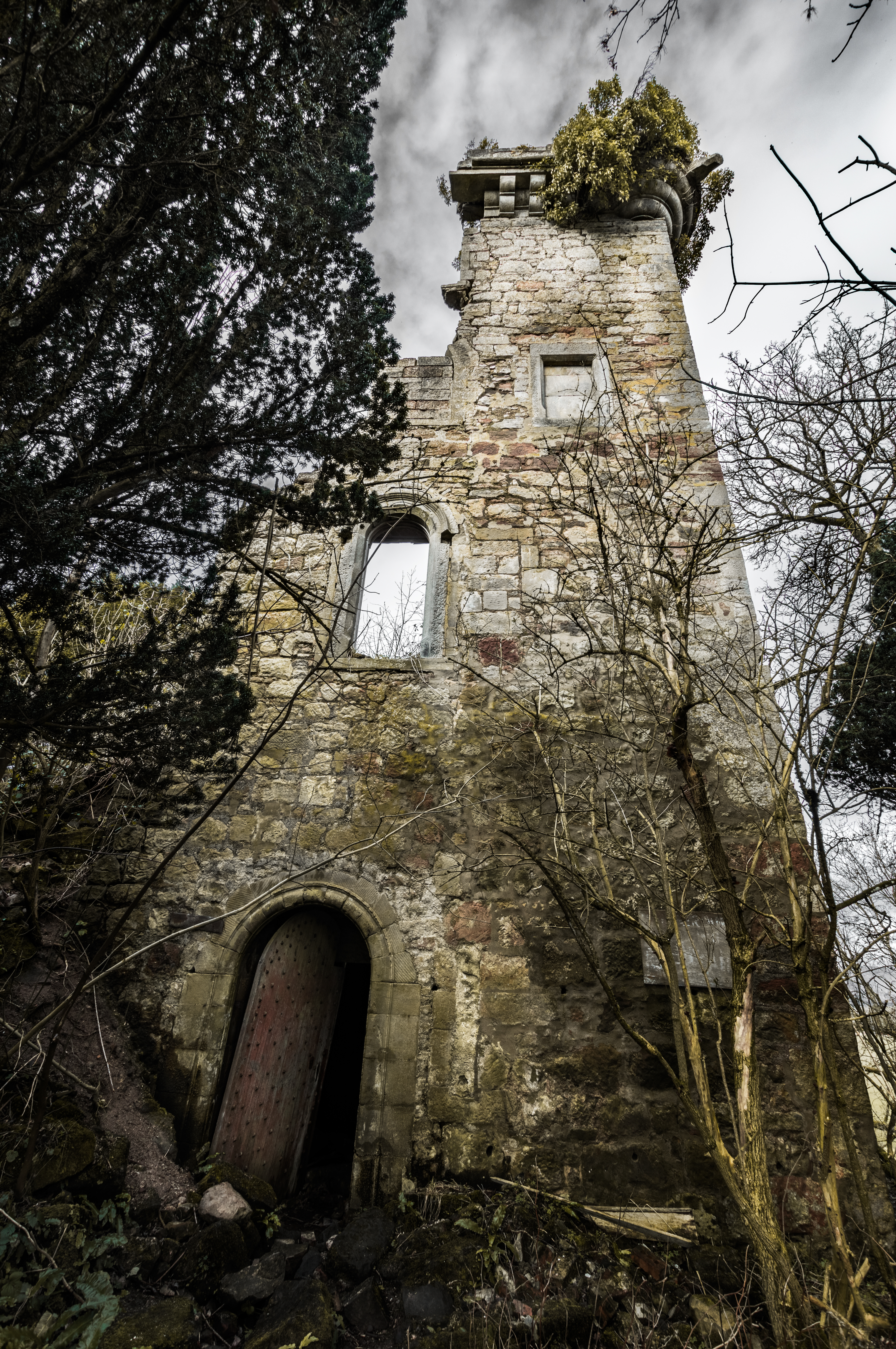
Elphinstone Tower, Falkirk

Elphinstone Tower, also known as Dunmore Tower or Airth Tower, is a ruined tower house on the Dunmore Estate in central Scotland. It is located 1.5 kilometres...

Dunmore Pineapple

The Dunmore Pineapple is a folly in Dunmore Park, near Airth in Stirlingshire, Scotland. In 1995 it was ranked "as the most bizarre building in Scotland...

Airth

Airth (Scottish Gaelic: An Àird) is a Royal Burgh, village, former trading port and civil parish in Falkirk, Scotland. It is 6 miles (10 kilometres) north...

Nearby Amenities

Located within 500m of 56.084688,-3.780092
Created By: almien_coastlines
Lat/Long: 56.081646/-3.774308
Created By: almien_coastlines
Lat/Long: 56.0887769/-3.7829863
Dunmore
Place: village
Source: OS OpenData StreetView
Wikidata: Q5315498
Wikipedia: en:Dunmore, Falkirk
Lat/Long: 56.0849381/-3.7799944
Telephone
Booth: K6
Covered: booth
Man Made: telephone_box
Source: survey
Lat/Long: 56.0841081/-3.7819449
Turning Loop
Lat/Long: 56.0844228/-3.7826537
Bus Stop
Bus: yes
Naptan AtcoCode: 66903870012
Naptan NaptanCode: 32524758
Public Transport: platform
Shelter: yes
Lat/Long: 56.0838508/-3.7817997
Power: pole
Lat/Long: 56.0834679/-3.7802154
Power: pole
Lat/Long: 56.0839418/-3.7805639
Post Box
Collection Times: Mo-Fr 16:00; Sa 09:30
Post Box Design: waggon_top
Post Box Type: lamp
Ref: FK2 105
Royal Cypher: GVIR
Royal Cypher Wikidata: Q33102169
Lat/Long: 56.0840812/-3.7820279
The data included in this document is from www.openstreetmap.org. The data is made available under ODbL.

Have you been to Dunmore?

Leave your review of Dunmore below (or comments, questions and feedback).