Ash Nuiken
Wood, Forest in Yorkshire Hambleton
England
Ash Nuiken
Ash Nuiken, Yorkshire (Wood, Forest) is a charming village located in the picturesque county of Yorkshire, England. Nestled amidst the breathtaking landscapes of the region, this idyllic settlement is renowned for its natural beauty and tranquil atmosphere. Surrounded by dense woodlands and enchanting forests, Ash Nuiken offers a peaceful retreat for those seeking to escape the hustle and bustle of city life.
The village is characterized by its traditional architecture, with quaint cottages and charming stone houses dotting the landscape. The local community takes great pride in preserving the village's historic charm, and many of the buildings date back several centuries.
Nature enthusiasts will be delighted by the abundance of outdoor activities available in Ash Nuiken. The surrounding woodlands and forests provide ample opportunities for hiking, biking, and wildlife spotting. Visitors can explore the well-maintained walking trails that wind through the lush greenery, offering breathtaking views of the surrounding countryside.
In addition to its natural beauty, Ash Nuiken also boasts a close-knit and friendly community. The village is home to a range of amenities, including a local pub, a village hall, and a small convenience store. These facilities provide essential services and also serve as meeting points for residents and visitors alike, fostering a sense of community spirit.
Overall, Ash Nuiken, Yorkshire (Wood, Forest) is a hidden gem in the heart of Yorkshire. With its stunning natural landscapes, charming architecture, and welcoming community, it offers a delightful escape for those seeking a peaceful and rejuvenating getaway.
If you have any feedback on the listing, please let us know in the comments section below.
Ash Nuiken Images
Images are sourced within 2km of 54.369586/-1.0968532 or Grid Reference SE5897. Thanks to Geograph Open Source API. All images are credited.

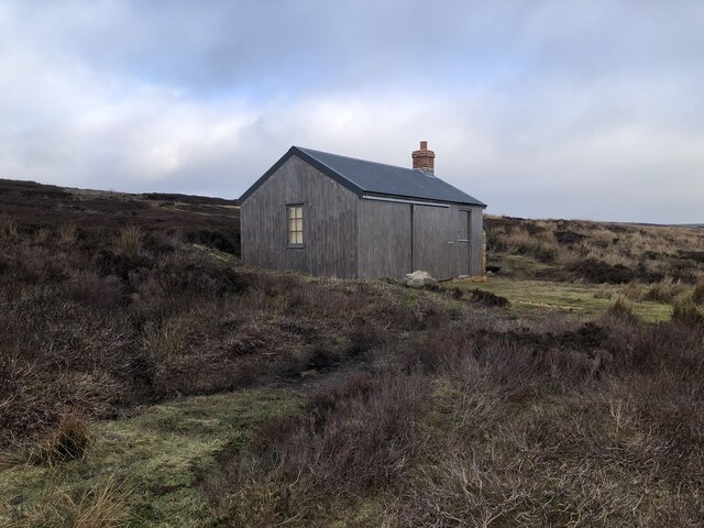
![Tarn Hole Had a trot up to the Bilsdale transmitter to see how the new mast was getting along. As it’s going to take 19 months, I shouldn’t have expected to see anything. There was just one bloke high up the temporary mast. What a view on a vernal morning.
The view was maybe not quite as good from ground level but still impressive.
Across the dale, the ‘secret’ valley of Tarn Hole dominates the far skyline. Secret because no Public Rights of Way pass through it and although the moorland above is Open Access, there are no well trod paths around the escarpment.
George Villiers, the 2nd Duke of Buckingham, was out hunting in Tarn Hole in 1687, when he fell, striking his head on a rock. He was taken to the house of a tenant in Kirkbymoorside, where he caught a chill and died. The rock on which he struck his head is known as the ‘Buckingham Stone’ but it’s not on Open Access Land and the landowner is quite protective so I won’t disclose exactly where it is.
Tarn Hole was the home of one of the moors many hobs, ‘T’Hob o’ Tarn Hole’, those mischievous mercurial elves that attach themselves to a farmstead. But I prefer to think he lived in the delightfully named Ash Nuiken, the woodland that bestrides the beck.
I said earlier there are no well trod paths around the escarpment but a Public Footpath does go from Apple Tree Hurst Farm [<a href="https://www.geograph.org.uk/gridref/SE5896">SE5896</a>]up to the moor and along to Tarn Hole Crag. I must explore this sometime.
Until very recently all the Public Rights of way through Apple Tree Hurst Farm were closed due to an “ongoing police” investigation. Apparently human body parts had been found there.
The story began in 2011 when police found a loaded Luger pistol under the owner’s pillow and a ‘museum’ in an outbuilding containing a military memorabilia a vast collection of machine guns, grenades, mortars and ammunition including the cockpit from a fighter jet.
The police had been following up a case of exposure by the owner, a Ken Ward, to a neighbour. If you want photographs and all the titillating details you best read the Daily Mail article.
Along with the guns, grenades, and pieces of aircraft wreckage, the Police found human remains. These have been identified as belonging to the pilot and navigator of a Mosquito plane, No. DZ543, which crashed on the moors above Bransdale on 11th October 1944. It was on a transit flight from Beccles to Turnberry airfield and hit the moor in low visibility.
The crew P/O Alfred Robert William Milne RAFVR, aged 22, and WO Eric Alan Stubbs RAFVR (1323395), also aged 22, were subsequently buried in Surrey.
But it seems that not all the body parts were recovered by the RAF at the time, and Ward, who had had an obsession with the crash since 1959, when aged 11, had carried out his own excavations to recover further pieces of aircraft for his collection and in doing also found human remains which the RAF had missed.
In their article the Daily Mail reports that “Police say they have now concluded their investigation without any further charges being brought against Ward.”
For links and references see <span class="nowrap"><a title="http://www.fhithich.uk/?p=27464" rel="nofollow ugc noopener" href="http://www.fhithich.uk/?p=27464">Link</a><img style="margin-left:2px;" alt="External link" title="External link - shift click to open in new window" src="https://s1.geograph.org.uk/img/external.png" width="10" height="10"/></span>](https://s2.geograph.org.uk/geophotos/07/10/91/7109122_7d3962e0.jpg)


![Cam House, Bilsdale Hillside farmhouse with a view over the dale. Recent tree planting below and to the right of the house across an area marked as &#039;Tips [disused]&#039; on the OS map. Old 6&quot; maps show these as old jet workings.](https://s3.geograph.org.uk/geophotos/07/11/84/7118495_a76ae01b.jpg)


Ash Nuiken is located at Grid Ref: SE5897 (Lat: 54.369586, Lng: -1.0968532)
Division: North Riding
Administrative County: North Yorkshire
District: Hambleton
Police Authority: North Yorkshire
What 3 Words
///printers.strumming.accented. Near Bilsdale, North Yorkshire
Nearby Locations
Related Wikis

Bilsdale Midcable
Bilsdale Midcable is a civil parish in North Yorkshire, England, which occupies the northern part of Bilsdale in the North York Moors National Park. According...

Bransdale
Bransdale is a valley running south through North Yorkshire, England, and part of the North York Moors National Park. Sandwiched between Bilsdale to the...

Cockayne, North Yorkshire
Cockayne is an isolated hamlet in North Yorkshire, England. It is the largest settlement in the civil parish of Bransdale, in the North York Moors national...
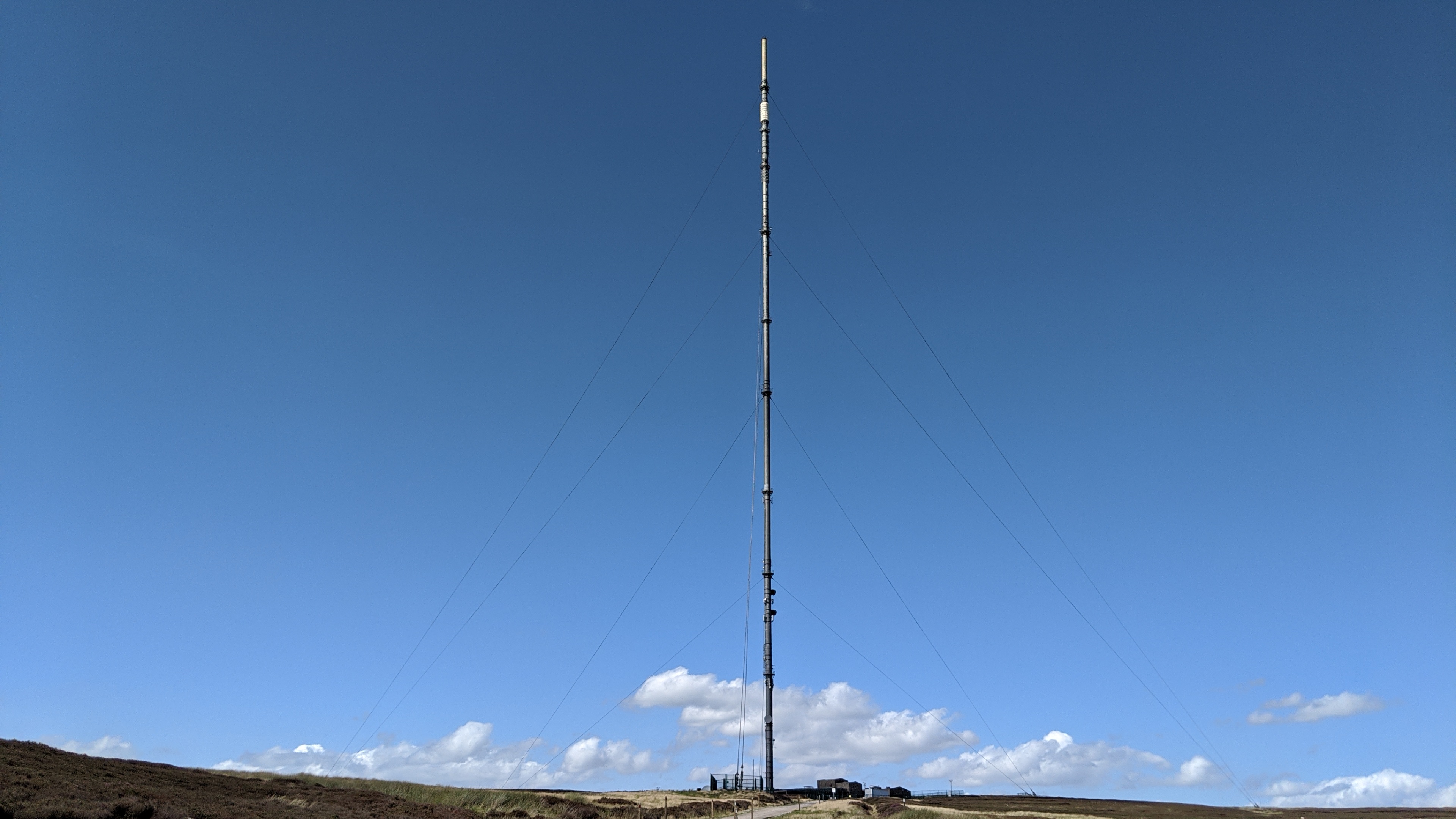
Bilsdale transmitting station
The Bilsdale transmitting station is a broadcasting and telecommunications facility, located at Bilsdale West Moor above Bilsdale, close to Helmsley, North...

Chop Gate
Chop Gate ( CHOP YAT) is a small village in the Hambleton district of North Yorkshire, England. The village lies within the North York Moors National Park...

Urra Moor
Urra Moor is the highest moor in the North York Moors, North Yorkshire, England. At 1,490 feet (454 m) above sea level it is the highest point in Hambleton...

Bilsdale
Bilsdale is a dale in the western part of the North York Moors in North Yorkshire, England. The head of the dale is at Hasty Bank, and the dale extends...

Laskill
Laskill is a small hamlet in Bilsdale, 5 miles (8 km) north-west of Helmsley, North Yorkshire, England, on the road from Helmsley to Stokesley and is located...
Nearby Amenities
Located within 500m of 54.369586,-1.0968532Have you been to Ash Nuiken?
Leave your review of Ash Nuiken below (or comments, questions and feedback).