Bathinghouse Grove

Wood, Forest in Hampshire Fareham

England

Bathinghouse Grove

The Golden Lion Pub The view of a traditional old English pub in Fareham High Street.
The Golden Lion Pub Credit: Gordon Griffiths

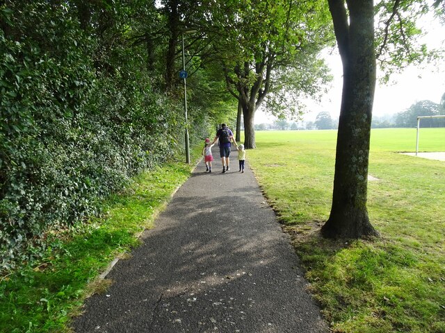
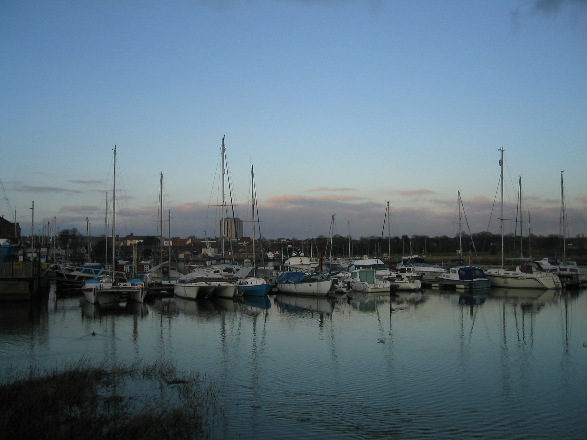
Bathinghouse Grove is a picturesque woodland located in Hampshire, England. Situated near the village of Bathinghouse, it covers an area of approximately 100 acres and is renowned for its natural beauty and diverse range of flora and fauna.

The grove is primarily composed of deciduous trees, such as oak, beech, and ash, which create a dense canopy that filters sunlight and provides a tranquil atmosphere. The forest floor is covered in a thick layer of moss and ferns, adding to its enchanting appeal. Additionally, Bathinghouse Grove is intersected by a small stream, which meanders through the woods, creating a soothing babbling sound.

The woodland is home to a wide variety of wildlife, making it a haven for nature enthusiasts and birdwatchers. Species such as deer, foxes, badgers, and rabbits can often be spotted among the trees, while the skies are frequented by a diverse range of birds, including woodpeckers, owls, and various species of songbirds.

Bathinghouse Grove offers several walking trails and picnic areas, allowing visitors to explore its natural wonders at their own pace. The paths wind through the forest, leading to hidden clearings and offering breathtaking views of the surrounding countryside. The grove is particularly popular in the spring and summer months when the trees are in full bloom, creating a vibrant tapestry of colors.

Overall, Bathinghouse Grove is a true gem in Hampshire, providing a peaceful retreat where visitors can immerse themselves in the beauty of nature and experience the tranquility of a woodland setting.

If you have any feedback on the listing, please let us know in the comments section below.

Bathinghouse Grove Images

Images are sourced within 2km of 50.848746/-1.1681901 or Grid Reference SU5805. Thanks to Geograph Open Source API. All images are credited.

The Golden Lion Pub The view of a traditional old English pub in Fareham High Street.
The Golden Lion Pub
The view of a traditional old English pub in Fareham High Street.
Fareham Roofs The view over High Street in Fareham.
Fareham Roofs
The view over High Street in Fareham.
High Street  The view in Fareham.
High Street
The view in Fareham.
On Hartlands Road, Fareham – 1969 The location as seen has disappeared with the creation of Western Way and its split-level junction with Gosport Road. The coach is roughly underneath the footbridge in this view <a title="https://www.geograph.org.uk/photo/2385672" href="https://www.geograph.org.uk/photo/2385672">Link</a> .

It belonged to Red & White of Chepstow, one of the nationalised companies under the British Transport Commission, and is probably working from Cardiff to Portsmouth. It is a Bristol RE with ECW coachwork, new in 1968.

This is one of a series of views featuring buses in the 60s, 70s, and 80s. <a title="https://www.geograph.org.uk/search.php?i=137652761" href="https://www.geograph.org.uk/search.php?i=137652761">Link</a>
On Hartlands Road, Fareham – 1969
The location as seen has disappeared with the creation of Western Way and its split-level junction with Gosport Road. The coach is roughly underneath the footbridge in this view Link . It belonged to Red & White of Chepstow, one of the nationalised companies under the British Transport Commission, and is probably working from Cardiff to Portsmouth. It is a Bristol RE with ECW coachwork, new in 1968. This is one of a series of views featuring buses in the 60s, 70s, and 80s. Link
Gosport Road at Gosport Quay - 1969 The location has seen significant change. The road itself has become a promenade following the construction of the new dual carriageway a bit to the west.

The vessel at the quay has an interesting history. It is the MV 'Mark Bowen', belonging to the firm T. Bowen & P. Caines. It started life in 1943 as a Royal Fleet Auxiliary vessel NAV Chattenden, carrying naval armaments, remaining in naval service until 1967 when it was sold. Bowen & Caines bought the vessel in 1969 and it was converted into an aggregates suction dredger, the form in which it is seen here.

The bus is Gosport & Fareham 38, a Seddon Pennine 4 with locally-built Strachans bodywork, new in 1968. It was one of the last vehicles to be bought before the company was bought by the National Bus Company, and represents the company's tradition of buying lightweight or second-hand vehicles.

This is one of a series of views featuring buses in the 60s, 70s, and 80s. <a title="https://www.geograph.org.uk/search.php?i=137652761" href="https://www.geograph.org.uk/search.php?i=137652761">Link</a>
Gosport Road at Gosport Quay - 1969
The location has seen significant change. The road itself has become a promenade following the construction of the new dual carriageway a bit to the west. The vessel at the quay has an interesting history. It is the MV 'Mark Bowen', belonging to the firm T. Bowen & P. Caines. It started life in 1943 as a Royal Fleet Auxiliary vessel NAV Chattenden, carrying naval armaments, remaining in naval service until 1967 when it was sold. Bowen & Caines bought the vessel in 1969 and it was converted into an aggregates suction dredger, the form in which it is seen here. The bus is Gosport & Fareham 38, a Seddon Pennine 4 with locally-built Strachans bodywork, new in 1968. It was one of the last vehicles to be bought before the company was bought by the National Bus Company, and represents the company's tradition of buying lightweight or second-hand vehicles. This is one of a series of views featuring buses in the 60s, 70s, and 80s. Link
Park Path The view in Bath Lane Recreation Ground, Fareham.
Park Path
The view in Bath Lane Recreation Ground, Fareham.
Fareham Boats The view from Bath Lane Recreation Ground.
Fareham Boats
The view from Bath Lane Recreation Ground.
Fareham Park The view of Bath Lane Recreation Ground.
Fareham Park
The view of Bath Lane Recreation Ground.
Fareham Sainbury's The car park view in Fareham.
Fareham Sainbury's
The car park view in Fareham.
Vito Lounge - Restaurant in West Street This was previously the hardware retailer Robert Dyas. See <a href="https://www.geograph.org.uk/photo/6775089">SU5706 : West Street, Fareham (50)</a>.
Vito Lounge - Restaurant in West Street
This was previously the hardware retailer Robert Dyas. See SU5706 : West Street, Fareham (50).
Fareham Railway Station South Western Trains Class 450, No. 450059.
Fareham Railway Station
South Western Trains Class 450, No. 450059.
Fareham Railway Station
Footbridge, Fareham Railway Station
Fareham Railway Station
Fareham Railway Station GWR Class 166, No. 166205.
Fareham Railway Station
GWR Class 166, No. 166205.
Bus stop on Longfield Avenue
Houses on Jubilee Court
Show me another place!

Bathinghouse Grove is located at Grid Ref: SU5805 (Lat: 50.848746, Lng: -1.1681901)

Administrative County: Hampshire

District: Fareham

Police Authority: Hampshire

What 3 Words

///strutted.corrosive.picnic. Near Fareham, Hampshire

Related Wikis

Cams Hall

Cams Hall at Fareham, Hampshire, United Kingdom, is a Palladian mansion set in parkland overlooking Portsmouth Harbour. The land at Cams Hall was mentioned...

Wykeham House School

Wykeham House School is a former independent day school for girls and boys in market town of Fareham, Hampshire in South East England. Until its closure...

Fareham Common

Fareham Common is a suburb and small village near Fareham, Hampshire. The village lies 1.3 miles (2.8 km) north from the town of Fareham. The suburb is...

Cams Hill School

Cams Hill School is a medium-sized mixed secondary school for ages 11–16, located in Shearwater Avenue in Fareham, England. Along with The Henry Cort Community...

Fareham Academy

Fareham Academy is a medium-sized mixed secondary school, with five tiers of entry (ages 11–16), located in St Anne's Grove in Fareham, England. Along...

Wallington, Hampshire

Wallington is a village in Hampshire, part of the borough of Fareham. It is situated between Portsmouth and Southampton near where the River Wallington...

Borough of Fareham

The Borough of Fareham is a local government district with borough status in Hampshire, England. Its council is based in Fareham. Other places within the...

Fareham

Fareham ( FAIR-əm) is a market town at the north-west tip of Portsmouth Harbour, between the cities of Portsmouth and Southampton in south east Hampshire...

Nearby Amenities

Located within 500m of 50.848746,-1.1681901
Motorway Junction
Lat/Long: 50.8513184/-1.1720785
Traffic Signals
Lat/Long: 50.8530516/-1.1684514
Motorway Junction
Lat/Long: 50.8509698/-1.1727567
Source: PGS
Lat/Long: 50.8506664/-1.1692805
Source: PGS
Lat/Long: 50.8510739/-1.1691625
Source: PGS
Lat/Long: 50.8514925/-1.1686156
Source: PGS
Lat/Long: 50.8516401/-1.1684721
Source: PGS
Lat/Long: 50.8519241/-1.1682811
Source: PGS
Lat/Long: 50.8520719/-1.1682278
Source: PGS
Lat/Long: 50.8521818/-1.1682316
Source: PGS
Lat/Long: 50.8523198/-1.1683104
Source: PGS
Lat/Long: 50.8523977/-1.1684084
Source: PGS
Lat/Long: 50.8526363/-1.1672456
Source: PGS
Lat/Long: 50.8525384/-1.1669206
Source: PGS
Lat/Long: 50.8524369/-1.1664497
Source: PGS
Lat/Long: 50.850236/-1.1663184
Source: PGS
Lat/Long: 50.8499687/-1.1664752
Source: PGS
Lat/Long: 50.8497506/-1.1669518
Source: PGS
Lat/Long: 50.8489001/-1.1683707
Source: PGS
Lat/Long: 50.8486969/-1.1686298
Source: PGS
Lat/Long: 50.8485001/-1.1689748
Post Box
Brand: Royal Mail
Brand Wikidata: Q638098
Collection Plate: Not sure
Collection Times: Mo-Fr 16:00; Sa 11:30
Operator: Royal Mail
Operator Wikidata: Q638098
Post Box Type: pillar
Ref: PO16 22
Royal Cypher: GVIR
Royal Cypher Wikidata: Q33102169
Lat/Long: 50.852599/-1.1655995
Pub
The Delme Arms
Addr City: Fareham
Addr Country: GB
Addr Housenumber: 1
Addr Postcode: PO16 8QY
Addr Street: Cams Hill
Fhrs Id: 37318
Opening Hours: Mo-Th 12:00-23:00; Fr-Sa 11:00-00:00; Su 12:00-22:00
Phone: +44 1329 232638
Lat/Long: 50.8528645/-1.1659599
Traffic Signals
Lat/Long: 50.8521871/-1.1648871
Crossing
Crossing: marked
Lat/Long: 50.8521003/-1.1649038
Crossing
Crossing: traffic_signals
Crossing Ref: toucan
Lat/Long: 50.8527911/-1.1681072
Crossing
Crossing: traffic_signals
Crossing Ref: toucan
Lat/Long: 50.8529648/-1.1685311
Bus Stop
Delme Arms Ph
Bench: no
Bus: yes
Naptan AtcoCode: 1900HA040406
Naptan Bearing: W
Naptan CommonName: Delme Arms Ph
Naptan NaptanCode: hamdtpwg
Naptan PlusbusZoneRef: FAREHAM
Naptan Street: Cams Hill
Naptan Verified: no
Public Transport: platform
Shelter: no
Source: naptan_import
Tactile Paving: no
Lat/Long: 50.85226/-1.1655703
Bus Stop
Delme Arms Ph
Bench: yes
Bus: yes
Naptan AtcoCode: 1900HA040407
Naptan Bearing: E
Naptan CommonName: Delme Arms Ph
Naptan Crossing: The Dell
Naptan NaptanCode: hamdtwgj
Naptan PlusbusZoneRef: FAREHAM
Naptan Street: Cams Hill
Naptan Verified: no
Public Transport: platform
Seating: Inside this bus shelter is some seating.
Shelter: yes
Source: naptan_import
Source 1: survey
Tactile Paving: no
Lat/Long: 50.8522322/-1.164207
Crossing
Crossing: unmarked
Kerb: flush
Tactile Paving: yes
Lat/Long: 50.852417/-1.1685346
Source: PGS
Lat/Long: 50.8494901/-1.171503
Crossing
Crossing: unmarked
Kerb: flush
Tactile Paving: yes
Lat/Long: 50.8526398/-1.1661109
Post Box
Collection Plate: CP7D
Collection Times: Mo-Fr 09:00; Sa 07:00
Post Box Type: wall
Ref: PO16 48
Royal Cypher: EIIR
Royal Cypher Wikidata: Q33102113
Lat/Long: 50.850667/-1.1705985
Noexit: yes
Lat/Long: 50.8497448/-1.1704034
Traffic Signals
Lat/Long: 50.8522808/-1.1648553
Barrier: height_restrictor
Maxheight: 2.5
Source: survey
Lat/Long: 50.8514452/-1.1720933
Grit Bin
Operator: Hampshire County Council
Source: survey
Lat/Long: 50.8515154/-1.1718855
North Park
Place: locality
Lat/Long: 50.8503206/-1.1625199
Swan Quay
Place: locality
Lat/Long: 50.8495575/-1.1699517
Post Box
Brand: Royal Mail
Brand Wikidata: Q638098
Collection Plate: CP8
Collection Times: Mo-Fr 17:15; Sa 12:30
Operator: Royal Mail
Operator Wikidata: Q638098
Post Box Type: pillar
Ref: PO16 170
Royal Cypher: EIIR
Royal Cypher Wikidata: Q33102113
Lat/Long: 50.8488911/-1.165656
Source: PGS
Lat/Long: 50.8496432/-1.1707627
Source: PGS
Lat/Long: 50.8494571/-1.1702971
Source: PGS
Lat/Long: 50.8495735/-1.169338
Source: PGS
Lat/Long: 50.8524369/-1.1664497
Source: PGS
Lat/Long: 50.8524559/-1.166409
Crossing
Crossing: unmarked
Kerb: flush
Tactile Paving: yes
Lat/Long: 50.8525428/-1.1661963
Crossing
Crossing: marked
Lat/Long: 50.8522315/-1.1646063
Crossing
Crossing: marked
Lat/Long: 50.8521136/-1.1645076
The data included in this document is from www.openstreetmap.org. The data is made available under ODbL.

Have you been to Bathinghouse Grove?

Leave your review of Bathinghouse Grove below (or comments, questions and feedback).