Stonylands Copse

Wood, Forest in Hampshire Basingstoke and Deane

England

Stonylands Copse

Farmland near Baughurst This square is largely farmland and a network of minor roads. This view was taken near the footpath, at the intersection in the adjacent square. The view looks southeast along the road.
Farmland near Baughurst Credit: Pam Brophy

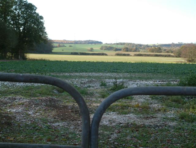
Stonylands Copse is a picturesque woodland located in Hampshire, England. Covering an area of approximately 50 acres, it is known for its diverse range of flora and fauna, making it a popular destination for nature enthusiasts and hikers.

The copse is characterized by its dense and mature tree canopy, consisting primarily of oak, beech, and birch trees. These towering trees provide ample shade, creating a cool and tranquil atmosphere within the woodland. The forest floor is covered with a lush carpet of bluebells in spring, adding a vibrant burst of color to the surroundings.

The copse is home to a variety of wildlife, including deer, foxes, badgers, and a wide range of bird species such as woodpeckers and owls. Visitors may also spot smaller creatures such as squirrels, hedgehogs, and rabbits scurrying through the undergrowth.

Trails wind their way through the copse, offering visitors the opportunity to explore its natural beauty and discover hidden gems along the way. These paths are well-maintained, providing a pleasant walking experience for people of all ages and abilities.

Stonylands Copse is not only a haven for wildlife but also a valuable habitat for numerous plant species. The woodland boasts a rich biodiversity, with an array of wildflowers, ferns, and mosses thriving within its boundaries.

Overall, Stonylands Copse is a captivating woodland that offers visitors a chance to escape the hustle and bustle of everyday life and immerse themselves in the beauty of nature.

If you have any feedback on the listing, please let us know in the comments section below.

Stonylands Copse Images

Images are sourced within 2km of 51.324497/-1.178961 or Grid Reference SU5758. Thanks to Geograph Open Source API. All images are credited.

Farmland near Baughurst This square is largely farmland and a network of minor roads. This view was taken near the footpath, at the intersection in the adjacent square. The view looks southeast along the road.
Farmland near Baughurst
This square is largely farmland and a network of minor roads. This view was taken near the footpath, at the intersection in the adjacent square. The view looks southeast along the road.
St  Stephen's near Baughurst This square is mostly farmland and also contains this church. This view taken from the only spot where one can get the whole building in the picture comfortably, is from the north east.
St Stephen's near Baughurst
This square is mostly farmland and also contains this church. This view taken from the only spot where one can get the whole building in the picture comfortably, is from the north east.
St Stephen's and the graveyard, near Baughurst This view of the church and gravestones, backlit against the late afternoon sun, was taken from more or less the east side of the church. The church is surrounded by the graveyard on three sides, the west side of the church being right on the boundary of the church grounds.
St Stephen's and the graveyard, near Baughurst
This view of the church and gravestones, backlit against the late afternoon sun, was taken from more or less the east side of the church. The church is surrounded by the graveyard on three sides, the west side of the church being right on the boundary of the church grounds.
Paddock near Browning Hill Green This square being largely farmland also has a paddock or two. This paddock is in the north western section of the square.
Paddock near Browning Hill Green
This square being largely farmland also has a paddock or two. This paddock is in the north western section of the square.
Farmland near Stratton Manor This view (where the road takes a sharp turn) shows the entrance to Stratton Manor on the left and the farmland behind the trees is in the east section of the square.
Farmland near Stratton Manor
This view (where the road takes a sharp turn) shows the entrance to Stratton Manor on the left and the farmland behind the trees is in the east section of the square.
A Neat Haystack near Coombe House Farm This square is farmland but also contains Brownhill Copse and two other smaller copses.
A Neat Haystack near Coombe House Farm
This square is farmland but also contains Brownhill Copse and two other smaller copses.
Skyers Farm Ramsdell Skyers Farm looking south from the road to Ramsdell.
Skyers Farm Ramsdell
Skyers Farm looking south from the road to Ramsdell.
The Wolverton Road The section of the road opposite Wolverton Wood in the south eastern section of the grid square. It runs diagonally across this section of the square and the field on the western side of the road is just visible. The picture was taken looking north east along the road.
The Wolverton Road
The section of the road opposite Wolverton Wood in the south eastern section of the grid square. It runs diagonally across this section of the square and the field on the western side of the road is just visible. The picture was taken looking north east along the road.
The George & Dragon Inn, Towns End
Towns End
Towns End
Wolverton Common
Wolverton Common
Portway  to Old Sarum The route of Portway, the old Roman road from Calleva (Silchester) to Old Sarum (Salisbury), and the South Coast. It runs in a straight line to the right of the wood which can be seen to the left of the image, almost directly above the middle of the gates.
Portway to Old Sarum
The route of Portway, the old Roman road from Calleva (Silchester) to Old Sarum (Salisbury), and the South Coast. It runs in a straight line to the right of the wood which can be seen to the left of the image, almost directly above the middle of the gates.
Looking West
Looking West
Looking South
Looking South
Ewhurst Park
Ewhurst Park
Farmland near Ewhurst Park Cut Wood is to the right of the rape-field. The first two pylons are within the grid-square.
Farmland near Ewhurst Park
Cut Wood is to the right of the rape-field. The first two pylons are within the grid-square.
Ewhurst Pond Looking across to Park Copse.
Ewhurst Pond
Looking across to Park Copse.
Wolverton House A handsome late Georgian manor house. Strangely, the house attracts no attention from most Hampshire guides. Perhaps its proximity to St Catherine's Church means that it is overlooked by visitors.

Wolverton formed part of the estate of the Duke of Wellington until the mid-20th century.
Wolverton House
A handsome late Georgian manor house. Strangely, the house attracts no attention from most Hampshire guides. Perhaps its proximity to St Catherine's Church means that it is overlooked by visitors. Wolverton formed part of the estate of the Duke of Wellington until the mid-20th century.
Show me another place!

Stonylands Copse is located at Grid Ref: SU5758 (Lat: 51.324497, Lng: -1.178961)

Administrative County: Hampshire

District: Basingstoke and Deane

Police Authority: Hampshire

What 3 Words

///advantage.fortunate.thirsty. Near Kingsclere, Hampshire

Related Wikis

Ramsdell

Ramsdell is a small village in the civil parish of Wootton St Lawrence with Ramsdell, in the Basingstoke and Deane district, in the English county of Hampshire...

Axmansford

Axmansford is a village in Hampshire, England. It is in the civil parish of Baughurst. == External links == Media related to Axmansford at Wikimedia Commons

Wolverton Common

Wolverton Common is a hamlet in north Hampshire, England. Its nearest town is Tadley, which lies approximately 2.5 miles (4 km) east from the hamlet....

Ewhurst, Hampshire

Ewhurst is a village in Hampshire, England, and 6.2 miles (10.0 km) northwest of Basingstoke. Its parish church dates from 1682. The village itself is...

Wolverton, Hampshire

Wolverton is a village in north Hampshire, England. It is within the civil parish of Baughurst, and located approximately 7 miles (11 km) from both Newbury...

West Heath, Hampshire

West Heath is a hamlet in the Basingstoke and Deane district of Hampshire, England. It is in the civil parish of Wootton St Lawrence. Its nearest town...

Charter Alley

Charter Alley is a village in north east Hampshire, England. According to the Post Office the majority of the population at the 2011 Census was included...

Inhurst

Inhurst is a hamlet in Hampshire, England. It is in the civil parish of Baughurst. == History == Inhurst House was established as a school in the 1960s...

Nearby Amenities

Located within 500m of 51.324497,-1.178961
The data included in this document is from www.openstreetmap.org. The data is made available under ODbL.

Have you been to Stonylands Copse?

Leave your review of Stonylands Copse below (or comments, questions and feedback).