Coneygrove Copse

Wood, Forest in Hampshire Basingstoke and Deane

England

Coneygrove Copse

Pylons At this point the pylons run directly in line with the road
Pylons Credit: Nygel Gardner

Coneygrove Copse is a picturesque woodland located in Hampshire, England. Situated near the village of Coneygrove, it covers an area of approximately 100 acres and is known for its diverse plant and animal life.

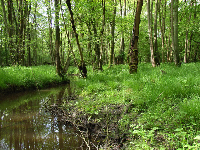
The copse is primarily made up of deciduous trees, including oak, beech, and birch, which create a stunning display of colors during the autumn months. The dense canopy provides shelter for a wide variety of wildlife, making it a popular spot for birdwatchers and nature enthusiasts. Visitors may spot species such as woodpeckers, owls, and various songbirds.

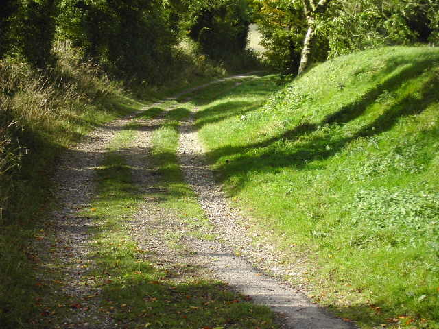
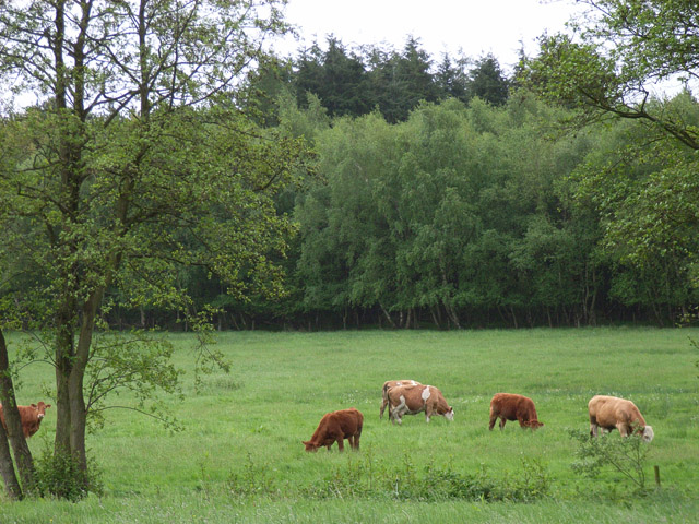
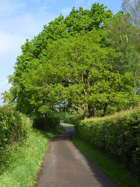
Tranquil walking trails wind their way through the copse, allowing visitors to explore the natural beauty at their own pace. These paths are well-maintained and suitable for all ages and abilities. Along the way, hikers may encounter small streams, wildflowers, and even the occasional deer or fox.

Coneygrove Copse is also home to a number of rare and protected flora and fauna. The woodland provides an important habitat for several species of orchids, as well as various ferns and mosses. Additionally, the copse supports a diverse insect population, including butterflies, bees, and beetles.

The copse is managed by the local forestry commission, who work to maintain the delicate balance of the ecosystem and ensure its preservation for future generations. With its natural beauty and biodiversity, Coneygrove Copse is a true gem of Hampshire, offering visitors a peaceful retreat into nature.

If you have any feedback on the listing, please let us know in the comments section below.

Coneygrove Copse Images

Images are sourced within 2km of 51.317115/-1.2051076 or Grid Reference SU5557. Thanks to Geograph Open Source API. All images are credited.

Pylons At this point the pylons run directly in line with the road
Pylons
At this point the pylons run directly in line with the road
Country house This picture was taken from approx 545582 and looks due north to a house just across the main A339
Country house
This picture was taken from approx 545582 and looks due north to a house just across the main A339
Shed on Legs! This old grain store was built on stone pillars to prevent rats from getting into the store. It is in the middle of a farm yard at 544576
Shed on Legs!
This old grain store was built on stone pillars to prevent rats from getting into the store. It is in the middle of a farm yard at 544576
Entrance to Bridleway This is the entrance to the bridleway starting at approx 543573 and is looking north westerly
Entrance to Bridleway
This is the entrance to the bridleway starting at approx 543573 and is looking north westerly
Farm Track This picture was taken from the cross roads in the bottom left hand corner of the square looking due east up the farm track.
Farm Track
This picture was taken from the cross roads in the bottom left hand corner of the square looking due east up the farm track.
Farm Track This picture was taken from the end of the farm track in the top left hand corner of the square looking north westerly. This track is private property as was very quickly (politely) pointed out by the farmer - although it is a public bridleway!
Farm Track
This picture was taken from the end of the farm track in the top left hand corner of the square looking north westerly. This track is private property as was very quickly (politely) pointed out by the farmer - although it is a public bridleway!
Dorrel Wood This picture was taken from just outside the square and looks due west to Dorrel Wood which is situated in the centre of this square.
Dorrel Wood
This picture was taken from just outside the square and looks due west to Dorrel Wood which is situated in the centre of this square.
The Wolverton Road The section of the road opposite Wolverton Wood in the south eastern section of the grid square. It runs diagonally across this section of the square and the field on the western side of the road is just visible. The picture was taken looking north east along the road.
The Wolverton Road
The section of the road opposite Wolverton Wood in the south eastern section of the grid square. It runs diagonally across this section of the square and the field on the western side of the road is just visible. The picture was taken looking north east along the road.
The George & Dragon Inn, Towns End
Towns End
Towns End
St. Catherine's Church, Crabbs Hill, Wolverton
Wolverton Common
Wolverton Common
Frith Common Looking across to Sandford Wood.
Frith Common
Looking across to Sandford Wood.
Farmland near Ewhurst Park Cut Wood is to the right of the rape-field. The first two pylons are within the grid-square.
Farmland near Ewhurst Park
Cut Wood is to the right of the rape-field. The first two pylons are within the grid-square.
Woodland stream, Frith Common The stream emanates from Sandford Springs, which give their name to the nearby golf club.
Woodland stream, Frith Common
The stream emanates from Sandford Springs, which give their name to the nearby golf club.
Lane at Frith Common Farm A public footpath on a private road.
Lane at Frith Common Farm
A public footpath on a private road.
Towards the downs Two bridleways join, then immediately separate again.  The one to the left continues to Plantation Farm.  The other goes through the hedge and straight up to the downs across open farmland.  Coronation Plantation on the skyline (right).
Towards the downs
Two bridleways join, then immediately separate again. The one to the left continues to Plantation Farm. The other goes through the hedge and straight up to the downs across open farmland. Coronation Plantation on the skyline (right).
Farmland above Kingsclere Taken from towards the southern edge of the square, this photo shows most of the eastern side.  The bridleway we are on runs south-north across the middle of the square with downland to the left and farmland to the right.  The bridleway from Plantation Farm to Kingsclere is seen as lower of the two hedgerows in the top right of the photo.  The small hill is just in the next square.
Farmland above Kingsclere
Taken from towards the southern edge of the square, this photo shows most of the eastern side. The bridleway we are on runs south-north across the middle of the square with downland to the left and farmland to the right. The bridleway from Plantation Farm to Kingsclere is seen as lower of the two hedgerows in the top right of the photo. The small hill is just in the next square.
Show me another place!

Coneygrove Copse is located at Grid Ref: SU5557 (Lat: 51.317115, Lng: -1.2051076)

Administrative County: Hampshire

District: Basingstoke and Deane

Police Authority: Hampshire

What 3 Words

///slid.dissolves.pumps. Near Kingsclere, Hampshire

Nearby Locations

Coneygrove Copse

Related Wikis

Wolverton Common

Wolverton Common is a hamlet in north Hampshire, England. Its nearest town is Tadley, which lies approximately 2.5 miles (4 km) east from the hamlet....

Wolverton, Hampshire

Wolverton is a village in north Hampshire, England. It is within the civil parish of Baughurst, and located approximately 7 miles (11 km) from both Newbury...

Ewhurst, Hampshire

Ewhurst is a village in Hampshire, England, and 6.2 miles (10.0 km) northwest of Basingstoke. Its parish church dates from 1682. The village itself is...

Axmansford

Axmansford is a village in Hampshire, England. It is in the civil parish of Baughurst. == External links == Media related to Axmansford at Wikimedia Commons

Kingsclere

Kingsclere is a large village and civil parish in Hampshire, England. == Geography == Kingsclere is approximately equidistant 13 kilometres (8.1 mi) from...

Hannington transmitting station

Hannington transmitting station is a television and radio transmitting station located on Cottington Hill near the village of Hannington, Hampshire. The...

Hannington, Hampshire

Hannington is a civil parish in the English county of Hampshire. It is situated between Basingstoke and Newbury, on the North Hampshire Downs in the North...

Ramsdell

Ramsdell is a small village in the civil parish of Wootton St Lawrence with Ramsdell, in the Basingstoke and Deane district, in the English county of Hampshire...

Nearby Amenities

Located within 500m of 51.317115,-1.2051076
Bus Stop
Hannington Turn
Bus: yes
Naptan AtcoCode: 1900HA010172
Naptan Bearing: NW
Naptan CommonName: Hannington Turn
Naptan Crossing: Rd to Hannington
Naptan NaptanCode: hamdpawa
Naptan Street: A339
Naptan Verified: no
Public Transport: platform
Source: naptan_import
Lat/Long: 51.3178931/-1.2094119
Bus Stop
Hannington Turn
Bus: yes
Naptan AtcoCode: 1900HA010173
Naptan Bearing: SE
Naptan CommonName: Hannington Turn
Naptan Crossing: Hannington Road
Naptan NaptanCode: hamdpawg
Naptan Street: A339
Naptan Verified: no
Public Transport: platform
Shelter: yes
Source: naptan_import
Lat/Long: 51.3179277/-1.2092104
Grit Bin
Operator: Hampshire County Council
Lat/Long: 51.3201057/-1.202493
Give Way
Lat/Long: 51.3175054/-1.2090975
The data included in this document is from www.openstreetmap.org. The data is made available under ODbL.

Have you been to Coneygrove Copse?

Leave your review of Coneygrove Copse below (or comments, questions and feedback).