Albert Plantation

Wood, Forest in Yorkshire

England

Albert Plantation

Sprotbrough. The barge Sobriety leaves Sprotbrough lock on the Sheffield and South Yorkshire Navigation on the River Don.
Sprotbrough. Credit: David Stowell

Albert Plantation is a scenic woodland located in the county of Yorkshire, England. Situated in a rural area, the plantation covers a vast area and is renowned for its natural beauty and diverse flora and fauna. The woodland is part of the wider Yorkshire Dales National Park, adding to its charm and appeal for nature enthusiasts and visitors alike.

The plantation is predominantly composed of deciduous trees, including oak, beech, and birch, which create a stunning canopy that changes with the seasons. This variation in foliage provides a picturesque setting throughout the year, with vibrant colors in autumn and lush greenery in spring and summer. The woodland floor is rich in wildflowers, creating a vibrant tapestry of colors and scents, attracting a wide range of wildlife.

With numerous walking trails and pathways, Albert Plantation offers an ideal location for outdoor activities such as hiking, birdwatching, and nature photography. The well-maintained trails provide easy access for visitors of all ages and abilities, allowing them to explore the woodland and discover its hidden gems.

The plantation is also home to a diverse range of wildlife. Bird species such as woodpeckers, owls, and thrushes can be spotted throughout the woodland, along with small mammals like squirrels and hedgehogs. Additionally, the plantation is known for its rich insect population, including butterflies and bees.

Overall, Albert Plantation in Yorkshire is a captivating woodland that offers a peaceful retreat, beautiful scenery, and abundant wildlife. Whether for a leisurely stroll, a picnic, or a day immersed in nature, this plantation is a must-visit destination for anyone seeking a natural escape in Yorkshire.

If you have any feedback on the listing, please let us know in the comments section below.

Albert Plantation Images

Images are sourced within 2km of 53.514008/-1.1735191 or Grid Reference SE5402. Thanks to Geograph Open Source API. All images are credited.

Sprotbrough. The barge Sobriety leaves Sprotbrough lock on the Sheffield and South Yorkshire Navigation on the River Don.
Sprotbrough.
The barge Sobriety leaves Sprotbrough lock on the Sheffield and South Yorkshire Navigation on the River Don.
Twin Railway Bridges, Warmsworth, South Yorkshire. Both bridges span the River Don. The nearest (disused) carried the line from Aire Junction to Braithwaite Junction, the other is the Doncaster avoiding line for freight and is still open. The Transpennine Trail and NCN 62 both follow the river and the disused railway at this point.
Twin Railway Bridges, Warmsworth, South Yorkshire.
Both bridges span the River Don. The nearest (disused) carried the line from Aire Junction to Braithwaite Junction, the other is the Doncaster avoiding line for freight and is still open. The Transpennine Trail and NCN 62 both follow the river and the disused railway at this point.
Loco Works Scrap Line, Doncaster Two Class 08 shunters near the end at the scrap yard within Doncaster Works, known locally as 'The Plant' in late October 1974
Loco Works Scrap Line, Doncaster
Two Class 08 shunters near the end at the scrap yard within Doncaster Works, known locally as 'The Plant' in late October 1974
Welcome . . . To Doncaster!
The sign, which presumably in the spring and summer of 2006 will become enclosed in flowers, vines and plants, announces to the happy driver, coming off at J.36 of the A1(M) that they have arrived in Doncaster, well, on the outskirts of Warmsworth anyway.  This is the roundabout above the motorway, where the A630 crosses it on its way east, into town.
Welcome . . .
To Doncaster! The sign, which presumably in the spring and summer of 2006 will become enclosed in flowers, vines and plants, announces to the happy driver, coming off at J.36 of the A1(M) that they have arrived in Doncaster, well, on the outskirts of Warmsworth anyway. This is the roundabout above the motorway, where the A630 crosses it on its way east, into town.
Quaker Lane, Warmsworth Presumably named after the Quaker Meeting House dating from 1705. George Fox, founder of the Society of Friends, known as the Quakers, often preached in Warmsworth.
Quaker Lane, Warmsworth
Presumably named after the Quaker Meeting House dating from 1705. George Fox, founder of the Society of Friends, known as the Quakers, often preached in Warmsworth.
The busy A630 just before the junction with the A1.
The busy A630
just before the junction with the A1.
Warmsworth Hall Built 1702, Warmsworth Hall is now part of a Holiday Inn hotel complex
Warmsworth Hall
Built 1702, Warmsworth Hall is now part of a Holiday Inn hotel complex
The Boat Inn, nr Sprotbrough Bridge
Sprotbrough Bridge
Sprotbrough Bridge
Road to Warmsworth
Road to Warmsworth
St Mary's Church, Sprotbrough probably 14th Century
St Mary's Church, Sprotbrough
probably 14th Century
Sprotbrough Post Office
Looking along the line of Melton Road, Sprotbrough looking eastwards towards Doncaster
Looking along the line of Melton Road, Sprotbrough
looking eastwards towards Doncaster
St Peter's This relatively modern church in Warmsworth has a rarely seen dome on its tower.
St Peter's
This relatively modern church in Warmsworth has a rarely seen dome on its tower.
Mini Adventure The red Mini is heading for another adventure on Challenger Drive, a modern housing development west of Doncaster.
Mini Adventure
The red Mini is heading for another adventure on Challenger Drive, a modern housing development west of Doncaster.
Dormer Row Clifton Drive gives a good display of dormer bungalows, perhaps mid to late 1970s.
Dormer Row
Clifton Drive gives a good display of dormer bungalows, perhaps mid to late 1970s.
Long Gone Railway This old railway bridge is so far from the past that this section barely shows on a modern map.  I would guess it to be a branch line to a now closed colliery.
Simon N Page tells us this is the Hull and Barnsley Railway. More information here <span class="nowrap"><a title="http://www.subbrit.org.uk/sb-sites/stations/s/sprotbrough/index.shtml" rel="nofollow ugc noopener" href="http://www.subbrit.org.uk/sb-sites/stations/s/sprotbrough/index.shtml">Link</a><img style="margin-left:2px;" alt="External link" title="External link - shift click to open in new window" src="https://s1.geograph.org.uk/img/external.png" width="10" height="10"/></span> .
Long Gone Railway
This old railway bridge is so far from the past that this section barely shows on a modern map. I would guess it to be a branch line to a now closed colliery. Simon N Page tells us this is the Hull and Barnsley Railway. More information here LinkExternal link .
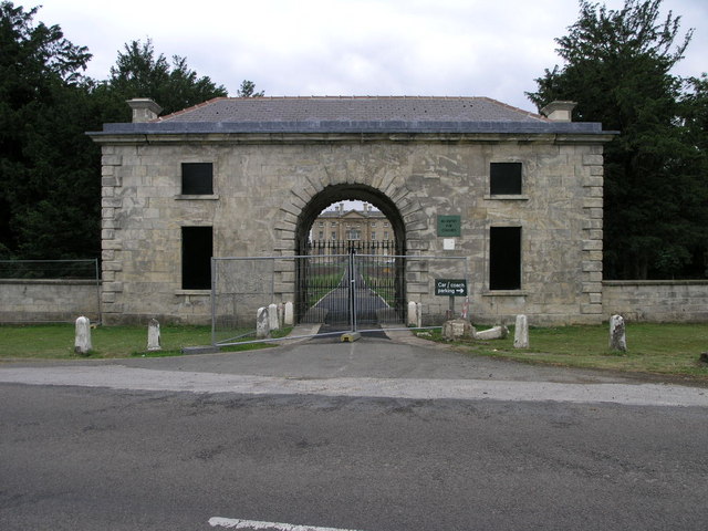
Big Gatehouse This elaborate gatehouse stands at the entrance to Cusworth Hall.  The hall can be seen in the background through the arch and also in the next square south.
Big Gatehouse
This elaborate gatehouse stands at the entrance to Cusworth Hall. The hall can be seen in the background through the arch and also in the next square south.
Show me another place!

Albert Plantation is located at Grid Ref: SE5402 (Lat: 53.514008, Lng: -1.1735191)

Division: West Riding

Unitary Authority: Doncaster

Police Authority: South Yorkshire

What 3 Words

///introduce.wildfires.sharpens. Near Bentley, South Yorkshire

Related Wikis

Don Bridge

The Don Bridge is a motorway viaduct in South Yorkshire, England. == History == The line of the fifteen-mile Doncaster By-Pass Motorway was fixed in the...

Sprotbrough

Sprotbrough is a village in the City of Doncaster in South Yorkshire, England, 3 miles (4.8 km) west of Doncaster city centre. With Cusworth to the north...

Hexthorpe railway platform

Hexthorpe railway platform was a short, wooden railway platform on the South Yorkshire Railway line about 1.5 miles (2.4 km) west of Doncaster in the area...

Hexthorpe rail accident

The Hexthorpe rail accident occurred on 16 September 1887 at Hexthorpe railway platform some 1.5 miles (2.4 km) west of Doncaster on the South Yorkshire...

Hexthorpe

Hexthorpe is a suburb of Doncaster, South Yorkshire, England. Historically part of the West Riding of Yorkshire, the area's shape resembles a rhombus,...

Sprotbrough and Cusworth

Sprotbrough and Cusworth is a civil parish in the City of Doncaster in South Yorkshire, England, with most of its settlements on the western edge of the...

Hexthorpe & Balby North (ward)

Hexthorpe & Balby North—consisting of Hexthorpe and the northern part of Balby—is one of 21 electoral wards in the Metropolitan Borough of Doncaster, South...

Sprotborough (SYR) railway station

Sprotborough (SYR) railway station was situated on the South Yorkshire Railway's line between Doncaster Cherry Tree Lane and Conisbrough. The station was...

Nearby Amenities

Located within 500m of 53.514008,-1.1735191
Bus Stop
Melton Road/Park Drive
Bus: yes
Naptan AtcoCode: 370040234
Naptan Bearing: SW
Naptan CommonName: Melton Road/Park Drive
Naptan Indicator: 40234
Naptan Landmark: POST BOX
Naptan PlusbusZoneRef: ROTHCEN
Naptan Street: Melton Road
Naptan Verified: no
Public Transport: platform
Source: naptan_import
Lat/Long: 53.5162245/-1.1765375
Bus Stop
Melton Road/Parsons Flats
Bus: yes
Naptan AtcoCode: 370041125
Naptan Bearing: N
Naptan CommonName: Melton Road/Parsons Flats
Naptan Indicator: 41125
Naptan Landmark: PARSONS FLATS
Naptan PlusbusZoneRef: ROTHCEN
Naptan Street: Melton Road
Naptan Verified: no
Public Transport: platform
Source: naptan_import
Lat/Long: 53.5171147/-1.1726743
Bus Stop
Melton Road/Clifton Drive
Bus: yes
Naptan AtcoCode: 370041130
Naptan Bearing: N
Naptan CommonName: Melton Road/Clifton Drive
Naptan Indicator: 41130
Naptan Landmark: PARSONS FLATS
Naptan PlusbusZoneRef: ROTHCEN
Naptan Street: Melton Road
Naptan Verified: no
Public Transport: platform
Source: naptan_import
Lat/Long: 53.5179867/-1.1713904
Bus Stop
Melton Road/Park Drive
Bus: yes
Naptan AtcoCode: 370045162
Naptan Bearing: NE
Naptan CommonName: Melton Road/Park Drive
Naptan Indicator: 45162
Naptan Landmark: POST BOX
Naptan PlusbusZoneRef: ROTHCEN
Naptan Street: Melton Road
Naptan Verified: no
Public Transport: platform
Source: naptan_import
Lat/Long: 53.5162996/-1.1770036
Bench
Backrest: yes
Material: wood
Seats: 4
Lat/Long: 53.5162901/-1.1768892
Post Box
Brand: Royal Mail
Brand Wikidata: Q638098
Operator: Royal Mail
Operator Wikidata: Q638098
Lat/Long: 53.5161453/-1.1768139
Power: tower
Source: Bing
Lat/Long: 53.5168896/-1.1692181
Power: tower
Source: Bing
Lat/Long: 53.5174573/-1.1725548
Man Made: tower
Note: Approximate location
Source: survey
Tower Type: communication
Lat/Long: 53.5156551/-1.1743002
Power: tower
Lat/Long: 53.5181157/-1.176516
Power: pole
Lat/Long: 53.5164373/-1.1731143
Power: pole
Lat/Long: 53.5165886/-1.1684859
Power: pole
Lat/Long: 53.5165889/-1.1712918
Power: pole
Lat/Long: 53.5171713/-1.1745914
Material: wood
Power: pole
Lat/Long: 53.5171875/-1.1755311
Power: pole
Lat/Long: 53.5172227/-1.1771581
Generator Method: photovoltaic
Generator Output Electricity: yes
Generator Source: solar
Generator Type: solar_photovoltaic_panel
Location: roof
Power: generator
Lat/Long: 53.5144618/-1.1754428
Sprotbrough Junction
Railway: junction
Lat/Long: 53.5143522/-1.1662173
The data included in this document is from www.openstreetmap.org. The data is made available under ODbL.

Have you been to Albert Plantation?

Leave your review of Albert Plantation below (or comments, questions and feedback).