Ashen Copse

Wood, Forest in Berkshire

England

Ashen Copse

Old Pit on Crookham Common One of several small ponds on the common near here. I don't know why the map doesn't show this area as access land like the rest of the common, because on the ground there is no distinction.
Old Pit on Crookham Common Credit: Des Blenkinsopp

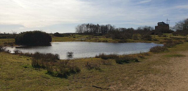
Ashen Copse, located in Berkshire, is a picturesque woodland area renowned for its natural beauty and rich biodiversity. Covering an area of approximately 100 acres, this enchanting forest offers visitors a tranquil escape from the hustle and bustle of everyday life.

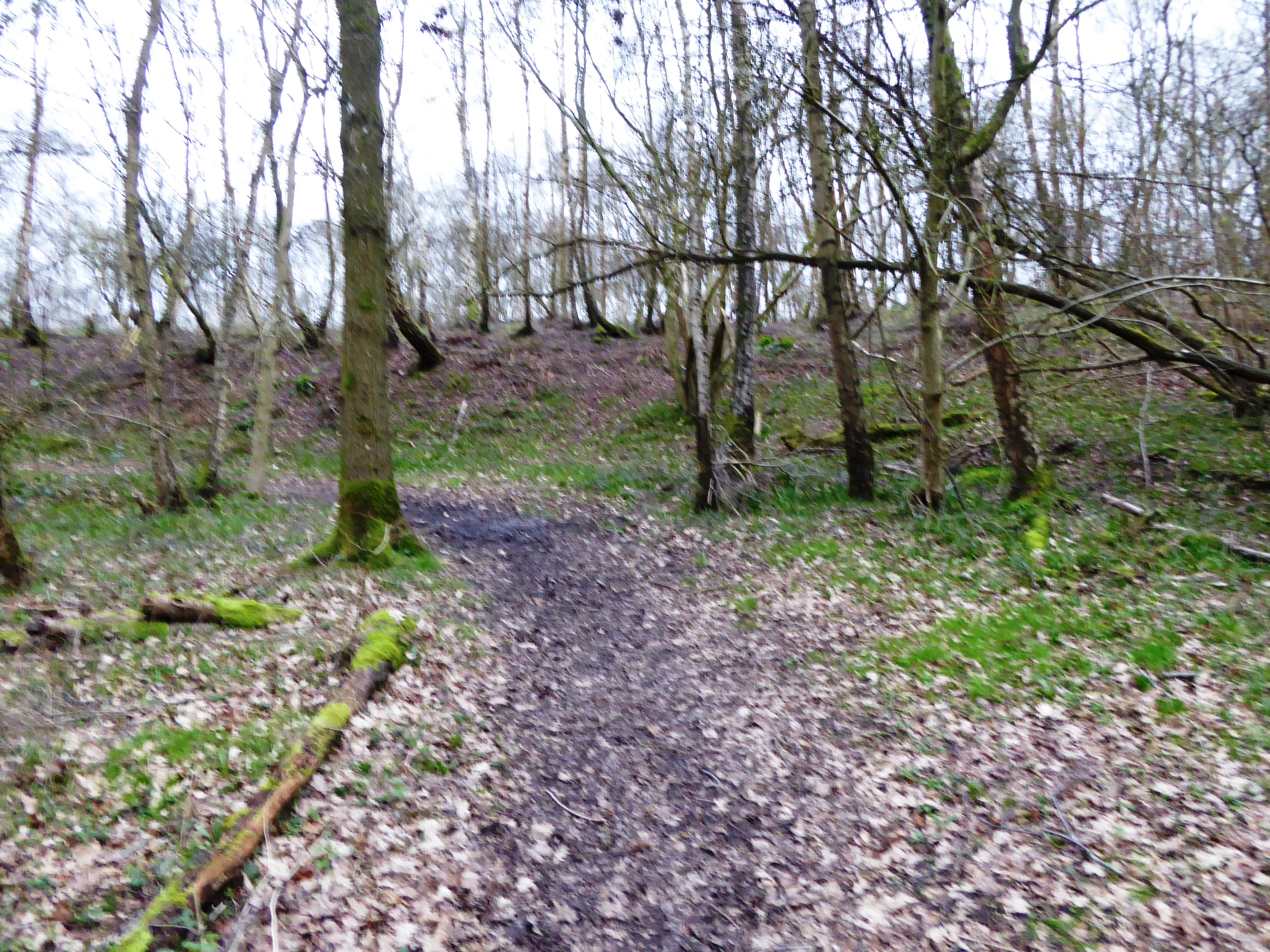
The copse is predominantly composed of native broadleaf trees such as oak, beech, and birch, which contribute to its vibrant and diverse ecosystem. The dense canopy of foliage creates a cool and shaded environment, perfect for leisurely walks or picnics during warm summer days.

The forest floor is blanketed with a variety of wildflowers, ferns, and mosses, adding to the copse's unique charm. Bluebells, primroses, and wood anemones are just some of the vibrant flora that can be spotted during the spring months, creating a colorful carpet beneath the towering trees.

Ashen Copse is also home to a plethora of wildlife, making it a haven for nature enthusiasts and birdwatchers. Visitors may catch glimpses of woodland birds like the great spotted woodpecker, nuthatch, and treecreeper, as well as mammals such as deer, foxes, and badgers. The copse is especially popular among birdwatchers during the breeding season, as it attracts a variety of songbirds.

In addition to its natural beauty, Ashen Copse offers several well-maintained walking trails, allowing visitors to explore its wonders at their own pace. These trails range from easy strolls suitable for families to more challenging routes for experienced hikers.

Overall, Ashen Copse in Berkshire is a captivating woodland retreat that offers visitors a chance to immerse themselves in nature's tranquility while enjoying its diverse flora and fauna.

If you have any feedback on the listing, please let us know in the comments section below.

Ashen Copse Images

Images are sourced within 2km of 51.385487/-1.2583593 or Grid Reference SU5165. Thanks to Geograph Open Source API. All images are credited.

Old Pit on Crookham Common One of several small ponds on the common near here. I don't know why the map doesn't show this area as access land like the rest of the common, because on the ground there is no distinction.
Old Pit on Crookham Common
One of several small ponds on the common near here. I don't know why the map doesn't show this area as access land like the rest of the common, because on the ground there is no distinction.
The Edge of the Common A path beside Bury's Bank Road which is the northern boundary of Crookham Common along here.
The Edge of the Common
A path beside Bury's Bank Road which is the northern boundary of Crookham Common along here.
Trees starting on the heathland Following decades as a military airfield, Greenham Common is returning to a natural state. The thin gravel soil supports colourful expanses of heather, but birch trees are now starting to take over.
Trees starting on the heathland
Following decades as a military airfield, Greenham Common is returning to a natural state. The thin gravel soil supports colourful expanses of heather, but birch trees are now starting to take over.
Track on Greenham Common Good tracks like this are all over the common, plus a lot of smaller paths, making it very easy to get around.
Track on Greenham Common
Good tracks like this are all over the common, plus a lot of smaller paths, making it very easy to get around.
Bowdown Woods To the north of Bury's Bank Road, the scenery is quite different from the open heathland of Greenham Common to the south. It is predominantly woodland.
Bowdown Woods
To the north of Bury's Bank Road, the scenery is quite different from the open heathland of Greenham Common to the south. It is predominantly woodland.
Grazed pasture on Chamberhouse Farm, Thatcham Although Chamberhouse Farm is no longer a working farm the fields are rented out and it is good to see cattle grazing the damp meadows.
Grazed pasture on Chamberhouse Farm, Thatcham
Although Chamberhouse Farm is no longer a working farm the fields are rented out and it is good to see cattle grazing the damp meadows.
Pond at Greenham Common A shallow pond formed by heavy rain on Greenham Common. The old control tower - now a cafe - can be seen in the background.
Pond at Greenham Common
A shallow pond formed by heavy rain on Greenham Common. The old control tower - now a cafe - can be seen in the background.
Lay-by off Bury's Bank Road A lay-by off Bury's Bank Road beside Greenham Common. The road runs from Newbury to Thatcham, with livestock across part of it in-between two cattle grids.
Lay-by off Bury's Bank Road
A lay-by off Bury's Bank Road beside Greenham Common. The road runs from Newbury to Thatcham, with livestock across part of it in-between two cattle grids.
Lay-by off Bury's Bank Road A lay-by off Bury's Bank Road beside Greenham Common. The road runs from Newbury to Thatcham, with livestock across part of it in-between two cattle grids. The field to the right of the road is part of Greenham Common. The track to the left leads to a private dwelling.
Lay-by off Bury's Bank Road
A lay-by off Bury's Bank Road beside Greenham Common. The road runs from Newbury to Thatcham, with livestock across part of it in-between two cattle grids. The field to the right of the road is part of Greenham Common. The track to the left leads to a private dwelling.
Bowdown Woods entrance from car park The entrance to Bowdown Woods from the car park off Bury's Bank Road. The woods are suffering extensively from ash dieback disease, and many paths are closed because of it. Also in view is a rather smelly over-filled dog poo bin!
Bowdown Woods entrance from car park
The entrance to Bowdown Woods from the car park off Bury's Bank Road. The woods are suffering extensively from ash dieback disease, and many paths are closed because of it. Also in view is a rather smelly over-filled dog poo bin!
Bowdown Woods car park The car park at Bowdown Woods off Bury's Bank Road is rather bumpy, with a large 'roundabout' in the centre. Cars can park all round the edges of the track, and often down the access road to the car park on a weekend.
Bowdown Woods car park
The car park at Bowdown Woods off Bury's Bank Road is rather bumpy, with a large 'roundabout' in the centre. Cars can park all round the edges of the track, and often down the access road to the car park on a weekend.
Bowdown Woods entrance path The main path from the entrance gate off the car park into Bowdown Woods. At the fork in the path ahead, there are two directions: north east or east.
Bowdown Woods entrance path
The main path from the entrance gate off the car park into Bowdown Woods. At the fork in the path ahead, there are two directions: north east or east.
Bowdown Woods entrance path The main path from the entrance gate off the car park into Bowdown Woods. The gate at the end leads to the car park. The path to the left heads east.
Bowdown Woods entrance path
The main path from the entrance gate off the car park into Bowdown Woods. The gate at the end leads to the car park. The path to the left heads east.
Bowdown Woods A view through the woodland at Bowdown Woods, from the path near to the entrance to the woods.
Bowdown Woods
A view through the woodland at Bowdown Woods, from the path near to the entrance to the woods.
Start of wildlife walk at Bowdown Woods To the left of the main path from the entrance to Bowdown Woods is a 'wildlife walk' that runs in a loop past Bowdown House and Bowdown Farm. The start of the walk is characterised by a little undulation in the path. To the left in this image are the grounds of Bowdown House.
Start of wildlife walk at Bowdown Woods
To the left of the main path from the entrance to Bowdown Woods is a 'wildlife walk' that runs in a loop past Bowdown House and Bowdown Farm. The start of the walk is characterised by a little undulation in the path. To the left in this image are the grounds of Bowdown House.
Path north east in Bowdown Woods The main entrance path leads straight on to this path at the fork to the wildlife walk by Bowdown House and Bowdown Farm. This path leads to another loop and has wider paths than the wildlife walk.
Path north east in Bowdown Woods
The main entrance path leads straight on to this path at the fork to the wildlife walk by Bowdown House and Bowdown Farm. This path leads to another loop and has wider paths than the wildlife walk.
Bowdown Woods entrance path The entrance path to Bowdown Woods from the car park, photographed from beside the start of the wildlife walk by Bowdown House and Bowdown Farm.
Bowdown Woods entrance path
The entrance path to Bowdown Woods from the car park, photographed from beside the start of the wildlife walk by Bowdown House and Bowdown Farm.
Large trees in Bowdown Woods Large trees near to the path of the wildlife walk in Bowdown Woods. The sign on the post has a QR code and offers a guided tour with audio for the trail.
Large trees in Bowdown Woods
Large trees near to the path of the wildlife walk in Bowdown Woods. The sign on the post has a QR code and offers a guided tour with audio for the trail.
Show me another place!

Ashen Copse is located at Grid Ref: SU5165 (Lat: 51.385487, Lng: -1.2583593)

Unitary Authority: West Berkshire

Police Authority: Thames Valley

What 3 Words

///income.city.chop. Near Thatcham, Berkshire

Related Wikis

Bowdown and Chamberhouse Woods

Bowdown and Chamberhouse Woods is a 67.9-hectare (168-acre) biological Site of Special Scientific Interest south of Thatcham in Berkshire. An area of 55...

Monkey Marsh Lock

Monkey Marsh Lock is a lock on the Kennet and Avon Canal, at Thatcham, Berkshire, England. Monkey Marsh Lock was built between 1718 and 1723 under the...

Widmead Lock

Widmead Lock is a lock on the Kennet and Avon Canal, between Newbury and Thatcham, Berkshire, England. Widmead Lock was built between 1718 and 1723 under...

A.F.C. Aldermaston

A.F.C. Aldermaston is a football club based in Aldermaston, Berkshire, England. Affiliated to the Berks & Bucks Football Association, the club are currently...

Thatcham Reed Beds

Thatcham Reed Beds is a 67.4-hectare (167-acre) biological Site of Special Scientific Interest east of Newbury in Berkshire. It is part of the Kennet...

Thatcham railway station

Thatcham railway station serves the market town of Thatcham in Berkshire, England. It is 49 miles 45 chains (49.56 mi; 79.8 km) measured from the zero...

Heads Hill

Heads Hill is a hamlet on Crookham Common in the civil parish of Thatcham in the English county of Berkshire. It lies near to the A339 road off Thornford...

Greenham Preceptory

Greenham Preceptory was a preceptory of Knights Hospitaller at Greenham in the English county of Berkshire.The preceptory was established in 1199 and dissolved...

Nearby Amenities

Located within 500m of 51.385487,-1.2583593
Bench
Lat/Long: 51.3813212/-1.2558725
Natural: spring
Lat/Long: 51.3826354/-1.2583482
Power: pole
Lat/Long: 51.3875242/-1.2634934
Power: pole
Lat/Long: 51.3875744/-1.2618921
Power: pole
Lat/Long: 51.3878037/-1.2539179
Power: pole
Lat/Long: 51.3878556/-1.2522442
The data included in this document is from www.openstreetmap.org. The data is made available under ODbL.

Have you been to Ashen Copse?

Leave your review of Ashen Copse below (or comments, questions and feedback).