Bolsovermoor Plantation

Wood, Forest in Derbyshire Bolsover

England

Bolsovermoor Plantation

Farm track on Bolsover Moor Leads to Scarcliffe Grange.
Farm track on Bolsover Moor Credit: Jonathan Thacker

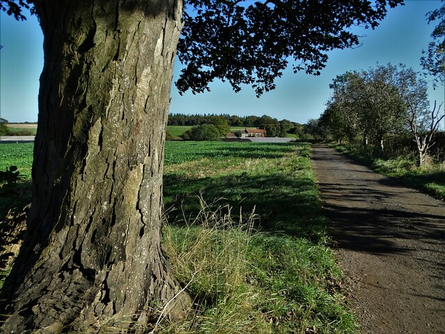
Bolsovermoor Plantation is a picturesque woodland located in Derbyshire, England. Covering an area of approximately 200 acres, this plantation is a haven for nature enthusiasts and offers a tranquil escape from the hustle and bustle of city life.

The woodland is primarily composed of a mixture of deciduous and coniferous trees, creating a diverse and vibrant ecosystem. Towering oak, beech, and ash trees dominate the landscape, providing a rich canopy that filters sunlight and creates a pleasant, shaded environment below. The understory is lush with ferns, mosses, and wildflowers, adding to the enchanting beauty of the woodland.

Bolsovermoor Plantation is crisscrossed by a network of well-maintained footpaths, making it easily accessible for hikers and walkers of all abilities. These paths wind through the woodland, offering visitors the opportunity to explore its hidden corners and discover its many delights. The plantation is also home to a variety of wildlife, including deer, foxes, squirrels, and a wide array of bird species, making it a popular spot for birdwatching and nature photography.

In addition to its natural beauty, Bolsovermoor Plantation has historical significance. The plantation has been managed and carefully preserved for centuries, ensuring the survival of its ancient trees and the continuation of its ecological legacy.

Overall, Bolsovermoor Plantation is a place of great natural and historical value. Its stunning woodland, diverse wildlife, and tranquil atmosphere make it a must-visit destination for nature lovers and those seeking a peaceful retreat in the heart of Derbyshire.

If you have any feedback on the listing, please let us know in the comments section below.

Bolsovermoor Plantation Images

Images are sourced within 2km of 53.236752/-1.2519692 or Grid Reference SK5071. Thanks to Geograph Open Source API. All images are credited.

Farm track on Bolsover Moor Leads to Scarcliffe Grange.
Farm track on Bolsover Moor
Leads to Scarcliffe Grange.
Harvested barley field, Bolsover Moor
Barley field, Bolsover Moor
Track to Scarcliffe Grange
Haystacks by Mooracre Lane These are directly opposite the entrance to Bolsover School. Some of these stacks have been here a while, with the smaller one having a healthy growth of grass on top of it.
Haystacks by Mooracre Lane
These are directly opposite the entrance to Bolsover School. Some of these stacks have been here a while, with the smaller one having a healthy growth of grass on top of it.
Entrance to Hedgerows A new green field housing site on the edge of Bolsover.
Entrance to Hedgerows
A new green field housing site on the edge of Bolsover.
Ongoing house building by Lawson Road Phased development of the new Hedgerows housing estate.
Ongoing house building by Lawson Road
Phased development of the new Hedgerows housing estate.
Wheat field on the edge of Bolsover Part of Rotherham Road is seen to the left, which acts as a ring road on the eastern side of Bolsover.
Wheat field on the edge of Bolsover
Part of Rotherham Road is seen to the left, which acts as a ring road on the eastern side of Bolsover.
Path through oil seed rape The path bypasses Scarcliffe Grange which is off to the right.
Path through oil seed rape
The path bypasses Scarcliffe Grange which is off to the right.
Farm tracks near Scarcliffe Grange These tracks are all in the estate of Scarcliffe Grange, but the right turn leads to the far. A hare ran across the grass ahead but I haven't managed to pick it up in the image.
Farm tracks near Scarcliffe Grange
These tracks are all in the estate of Scarcliffe Grange, but the right turn leads to the far. A hare ran across the grass ahead but I haven't managed to pick it up in the image.
Track to Scarcliffe Grange A footpath is marked off to the left. I wasn't sure it still existed amongst the crop, but you see it clearly enough when you get there.
Track to Scarcliffe Grange
A footpath is marked off to the left. I wasn't sure it still existed amongst the crop, but you see it clearly enough when you get there.
Cereal crop on Bolsover Moor It is too young for me to tell what the crop is.
Cereal crop on Bolsover Moor
It is too young for me to tell what the crop is.
Cereal crop on Bolsover Moor A wide expanse belonging to Scarcliffe Grange. I think this will be barley.
Cereal crop on Bolsover Moor
A wide expanse belonging to Scarcliffe Grange. I think this will be barley.
Petticoat Lane Leading to Petticoat Farm and its fields.
Petticoat Lane
Leading to Petticoat Farm and its fields.
Farmland by Petticoat Farm Arable farmland viewed from Suftig Road. A large solar farm is just out of sight over the ridge.
Farmland by Petticoat Farm
Arable farmland viewed from Suftig Road. A large solar farm is just out of sight over the ridge.
Marlpit Lane A pleasant rural lane, but the impending temporary closure relates to new house-building not far round the bend.
Marlpit Lane
A pleasant rural lane, but the impending temporary closure relates to new house-building not far round the bend.
Footpath near Keepers Hollow The path links Elmton Lane and Marlpit Lane.
Footpath near Keepers Hollow
The path links Elmton Lane and Marlpit Lane.
Excavators at work on Destination 14 Part of a large northwards expansion of Bolsover.
Excavators at work on Destination 14
Part of a large northwards expansion of Bolsover.
Show me another place!

Bolsovermoor Plantation is located at Grid Ref: SK5071 (Lat: 53.236752, Lng: -1.2519692)

Administrative County: Derbyshire

District: Bolsover

Police Authority: Derbyshire

What 3 Words

///paler.taps.envoy. Near Bolsover, Derbyshire

Related Wikis

Whaley

Whaley is a small village in Derbyshire, England, located one mile from Whaley Thorns, 1+1⁄2 miles from Elmton, 1+1⁄2 miles from Langwith and 2+1⁄2 miles...

Bolsover District

Bolsover District is a local government district in Derbyshire, England. It is named after the town of Bolsover, which is near the geographic centre of...

Bolsover Hospital

Bolsover Hospital was a community healthcare facility in Bolsover, Derbyshire. It was managed by Derbyshire Community Health Services NHS Foundation Trust...

The Bolsover School

The Bolsover School is a mixed secondary school located in Bolsover in the English county of Derbyshire.The previous buildings were closed in July 2010...

Elmton

Elmton is a linear village and former civil parish, now in the parish of Elmton with Creswell in the Bolsover district of Derbyshire, England, approximately...

Old Bolsover Town Council

Old Bolsover Town Council is the parish council for the civil parish of Old Bolsover in Derbyshire, England. It has responsibility for local issues in...

Bolsover

Bolsover is a market town and the administrative centre of the Bolsover District, Derbyshire, England. It is 18 miles (29 km) from Sheffield, 26 miles...

Bolsover Urban District

Bolsover was an Urban District in Derbyshire, England from 1894 to 1974. It was created under the Local Government Act 1894. The district was abolished...

Nearby Amenities

Located within 500m of 53.236752,-1.2519692
Parking
Description: Layby
Lat/Long: 53.2355158/-1.2541366
The data included in this document is from www.openstreetmap.org. The data is made available under ODbL.

Have you been to Bolsovermoor Plantation?

Leave your review of Bolsovermoor Plantation below (or comments, questions and feedback).