Bellow's Covert

Wood, Forest in Oxfordshire Cherwell

England

Bellow's Covert

Path to Paper Mill Cottages From Earl's Lane the path to Paper Mill Cottages
Path to Paper Mill Cottages Credit: Shaun Ferguson

Bellow's Covert is a picturesque woodland located in the county of Oxfordshire, England. Situated near the village of Wood, this forested area covers a significant expanse of land and boasts an array of natural beauty and wildlife.

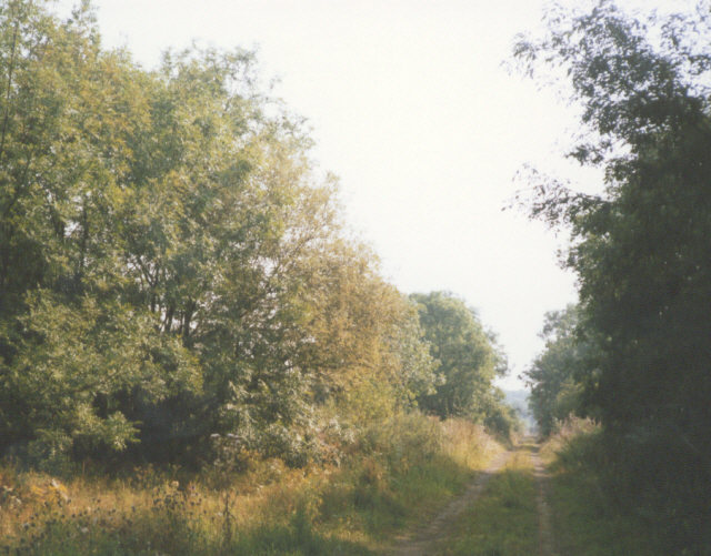
The woodland is known for its dense and ancient trees that provide a lush and serene environment for visitors to explore. The dominant species found in Bellow's Covert include oak, beech, and birch trees, creating a diverse and visually appealing landscape.

Home to a plethora of wildlife, Bellow's Covert offers nature enthusiasts an opportunity to observe various animals in their natural habitats. The forest is teeming with a wide range of bird species, including woodpeckers, owls, and a variety of songbirds. Additionally, deer, foxes, badgers, and rabbits can often be spotted within the woodland, adding to the allure of the area.

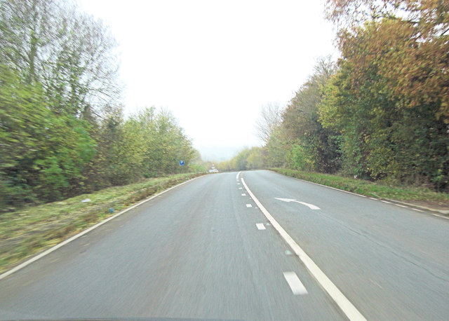
The forest is crisscrossed by a network of walking paths, allowing visitors to immerse themselves in the tranquility of the surroundings. These trails cater to different levels of difficulty, accommodating both casual walkers and more avid hikers. The diverse terrain, including gentle slopes and undulating hills, offers a scenic backdrop for outdoor activities such as picnicking, photography, and nature walks.

Bellow's Covert is a popular destination for nature lovers seeking a peaceful retreat from the hustle and bustle of city life. Its accessibility from Wood village and its abundant natural beauty make it a cherished gem within Oxfordshire's landscape.

If you have any feedback on the listing, please let us know in the comments section below.

Bellow's Covert Images

Images are sourced within 2km of 52.000919/-1.3275653 or Grid Reference SP4633. Thanks to Geograph Open Source API. All images are credited.

Path to Paper Mill Cottages From Earl's Lane the path to Paper Mill Cottages
Path to Paper Mill Cottages
From Earl's Lane the path to Paper Mill Cottages
Bridleway towards Deddington Mill From Windmill Street the bridleway towards Deddington Mill
Bridleway towards Deddington Mill
From Windmill Street the bridleway towards Deddington Mill
St Mary's Church, Adderbury
RAF Barford St John from the air Still in use, but not as an airfield. Click on this <span class="nowrap"><a title="http://en.wikipedia.org/wiki/RAF_Barford_St_John" rel="nofollow ugc noopener" href="http://en.wikipedia.org/wiki/RAF_Barford_St_John">Link</a><img style="margin-left:2px;" alt="External link" title="External link - shift click to open in new window" src="https://s1.geograph.org.uk/img/external.png" width="10" height="10"/></span> to go to the wikipedia article about the base. Viewed from a Heathrow bound flight from Glasgow.

See also <a href="https://www.geograph.org.uk/photo/2355944">SP4434 : RAF Barford St John from the air</a>.
RAF Barford St John from the air
Still in use, but not as an airfield. Click on this LinkExternal link to go to the wikipedia article about the base. Viewed from a Heathrow bound flight from Glasgow. See also SP4434 : RAF Barford St John from the air.
RAF Barford St John from the air Still in use, but not as an airfield. Click on this <span class="nowrap"><a title="http://en.wikipedia.org/wiki/RAF_Barford_St_John" rel="nofollow ugc noopener" href="http://en.wikipedia.org/wiki/RAF_Barford_St_John">Link</a><img style="margin-left:2px;" alt="External link" title="External link - shift click to open in new window" src="https://s1.geograph.org.uk/img/external.png" width="10" height="10"/></span> to go to the wikipedia article about the base. Viewed from a Heathrow bound flight from Glasgow.

See also <a href="https://www.geograph.org.uk/photo/2355941">SP4434 : RAF Barford St John from the air</a>.
RAF Barford St John from the air
Still in use, but not as an airfield. Click on this LinkExternal link to go to the wikipedia article about the base. Viewed from a Heathrow bound flight from Glasgow. See also SP4434 : RAF Barford St John from the air.
Approach to Twyford Mill Industrial Estate This site has been some sort of industrial or mill area for about 180 years culminating in aluminium working for aircraft production during WWII. It is now home to Aga, Fired Earth and Trade Secret.
Approach to Twyford Mill Industrial Estate
This site has been some sort of industrial or mill area for about 180 years culminating in aluminium working for aircraft production during WWII. It is now home to Aga, Fired Earth and Trade Secret.
A4260 south of Adderbury
Site of Adderbury station, 1992 View SE, towards Chipping Norton and Kingham: ex-GWR (Banbury) - Kings Sutton - Kingham line, closed 4/6/51, which once a subsidiary rail link between the Midlands and South Wales.
Site of Adderbury station, 1992
View SE, towards Chipping Norton and Kingham: ex-GWR (Banbury) - Kings Sutton - Kingham line, closed 4/6/51, which once a subsidiary rail link between the Midlands and South Wales.
Footpath from The Daedings to Daeda's Wood
"Spring" in Mackley Close I use the parentheses because it was the coldest Easter ever (Good Friday 29 March to Monday 1st April) and today was pretty much the same!
"Spring" in Mackley Close
I use the parentheses because it was the coldest Easter ever (Good Friday 29 March to Monday 1st April) and today was pretty much the same!
A4260 east of King's Spring
A4260 crosses Adderbury Bridge Under the unprepossessing bridge flows the River Swere: rising near Hook Norton and flowing south west to join the River Cherwell.
A4260 crosses Adderbury Bridge
Under the unprepossessing bridge flows the River Swere: rising near Hook Norton and flowing south west to join the River Cherwell.
Berry Hill Road approaching West Adderbury
Benchmark on former Independent Chapel Ordnance Survey cut mark benchmark described on the Bench Mark Database at <span class="nowrap"><a title="http://www.bench-marks.org.uk/bm48060" rel="nofollow ugc noopener" href="http://www.bench-marks.org.uk/bm48060">Link</a><img style="margin-left:2px;" alt="External link" title="External link - shift click to open in new window" src="https://s1.geograph.org.uk/img/external.png" width="10" height="10"/></span>
Benchmark on former Independent Chapel
Ordnance Survey cut mark benchmark described on the Bench Mark Database at LinkExternal link
'Independent Chapel 1820', New Road There is an OS benchmark <a href="https://www.geograph.org.uk/photo/3408521">SP4635 : Benchmark on former Independent Chapel</a> on the left side of the building by the gatepost at the entrance to 'South View'
'Independent Chapel 1820', New Road
There is an OS benchmark SP4635 : Benchmark on former Independent Chapel on the left side of the building by the gatepost at the entrance to 'South View'
Junction of Round Close Road and Cross Hill Road There is a Post Office at the corner with a post box inset in its wall
Junction of Round Close Road and Cross Hill Road
There is a Post Office at the corner with a post box inset in its wall
Benchmark on tower of St Mary's Church Ordnance Survey cut mark benchmark described on the Bench Mark Database at <span class="nowrap"><a title="http://www.bench-marks.org.uk/bm48073" rel="nofollow ugc noopener" href="http://www.bench-marks.org.uk/bm48073">Link</a><img style="margin-left:2px;" alt="External link" title="External link - shift click to open in new window" src="https://s1.geograph.org.uk/img/external.png" width="10" height="10"/></span>
Benchmark on tower of St Mary's Church
Ordnance Survey cut mark benchmark described on the Bench Mark Database at LinkExternal link
St Mary's Church There is an OS benchmark <a href="https://www.geograph.org.uk/photo/3409113">SP4735 : Benchmark on tower of St Mary's Church</a> in the middle of the tower face to the right of the gravestone in the foreground. The spire is an OS intersected station trig point, <span class="nowrap"><a title="http://www.trigpointinguk.com/trigs/trig-details.php?t=9694" rel="nofollow ugc noopener" href="http://www.trigpointinguk.com/trigs/trig-details.php?t=9694">Link</a><img style="margin-left:2px;" alt="External link" title="External link - shift click to open in new window" src="https://s1.geograph.org.uk/img/external.png" width="10" height="10"/></span>
St Mary's Church
There is an OS benchmark SP4735 : Benchmark on tower of St Mary's Church in the middle of the tower face to the right of the gravestone in the foreground. The spire is an OS intersected station trig point, LinkExternal link
Show me another place!

Bellow's Covert is located at Grid Ref: SP4633 (Lat: 52.000919, Lng: -1.3275653)

Administrative County: Oxfordshire

District: Cherwell

Police Authority: Thames Valley

What 3 Words

///extremely.verse.happy. Near Adderbury, Oxfordshire

Nearby Locations

Bellow's Covert

Related Wikis

Milton, Cherwell

Milton is a village and civil parish about 2.5 miles (4 km) south of Banbury in Oxfordshire, on the Milton road between the villages of Adderbury and Bloxham...

Adderbury railway station

Adderbury railway station served the village of Adderbury in Oxfordshire, England. == History == The station was built by the Banbury and Cheltenham Direct...

Milton Halt railway station

Milton Halt railway station is a former railway station that served the village of Milton in northern Oxfordshire, England. == History == The station was...

Adderbury

Adderbury is a winding linear village and rural civil parish about 3 miles (5 km) south of Banbury in northern Oxfordshire, England. The settlement has...

Sor Brook

The Sor Brook is a brook located mostly in Oxfordshire, in the South of England.From its source at Edge Hill in Warwickshire, it flows to the west of Banbury...

Deddington

Deddington is a civil parish and small town in Oxfordshire about 6 miles (10 km) south of Banbury. The parish includes two hamlets: Clifton and Hempton...

Deddington Town Hall

Deddington Town Hall is a municipal building in the Market Place in Deddington in Oxfordshire, England. The structure, which is used for community events...

Adderbury Lakes

Adderbury Lakes is a 1.8-hectare (4.4-acre) Local Nature Reserve in Adderbury in Oxfordshire. It is owned and managed by Adderbury Parish Council.The...

Nearby Amenities

Located within 500m of 52.000919,-1.3275653
Power: pole
Lat/Long: 52.0004663/-1.3206851
The data included in this document is from www.openstreetmap.org. The data is made available under ODbL.

Have you been to Bellow's Covert?

Leave your review of Bellow's Covert below (or comments, questions and feedback).