Goose Holme Wood

Wood, Forest in Yorkshire Hambleton

England

Goose Holme Wood

Entering  Kirklevington  on  Thirsk  Road
Entering Kirklevington on Thirsk Road Credit: Martin Dawes

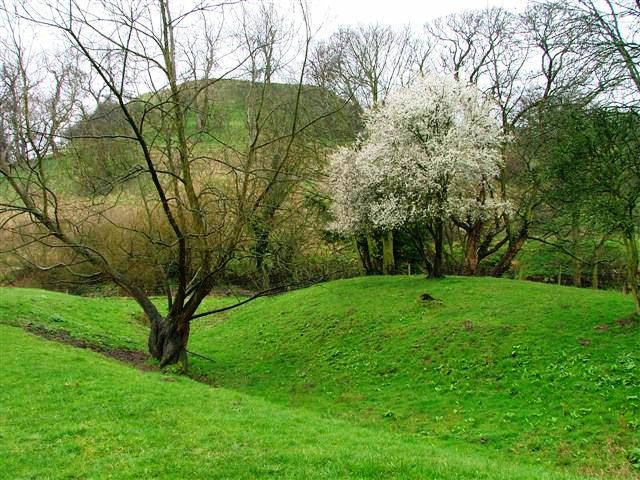
Goose Holme Wood is a picturesque woodland located in Yorkshire, England. Situated near the village of Holme, it covers an area of approximately 10 acres and is known for its natural beauty and diverse wildlife.

The woodland is primarily composed of mature oak and beech trees, which provide a dense canopy and create a peaceful and tranquil atmosphere. Walking through the wood, visitors can enjoy the dappled sunlight filtering through the branches, creating a magical and enchanting ambiance.

Goose Holme Wood is home to a wide variety of flora and fauna. Bluebells carpet the forest floor in the spring, creating a stunning display of vibrant color. The woodland is also known for its rich birdlife, with species such as great spotted woodpeckers, chiffchaffs, and tawny owls inhabiting the area. Small mammals like voles and squirrels can also be spotted scurrying among the undergrowth.

The wood is crisscrossed by a network of footpaths, allowing visitors to explore its beauty at their own pace. These paths meander through the trees, offering opportunities for peaceful walks and nature observation.

Goose Holme Wood is a popular destination for nature enthusiasts and those seeking a peaceful retreat. Its natural beauty, diverse wildlife, and tranquil atmosphere make it a haven for those looking to connect with nature and escape the hustle and bustle of everyday life.

If you have any feedback on the listing, please let us know in the comments section below.

Goose Holme Wood Images

Images are sourced within 2km of 54.464742/-1.3170772 or Grid Reference NZ4407. Thanks to Geograph Open Source API. All images are credited.

Entering  Kirklevington  on  Thirsk  Road
Entering Kirklevington on Thirsk Road
Minor  road  junction  on  A67
Minor road junction on A67
Road  signs  on  A67  toward  Kirklevington
Road signs on A67 toward Kirklevington
A lay-by on the A19 near Crathorne The A19 is a major road in North East England running approximately parallel to and east of the A1 road. The road runs from Seaton Burn south to Doncaster.
Wikipedia: <span class="nowrap"><a title="http://en.wikipedia.org/wiki/A19_road" rel="nofollow ugc noopener" href="http://en.wikipedia.org/wiki/A19_road">Link</a><img style="margin-left:2px;" alt="External link" title="External link - shift click to open in new window" src="https://s1.geograph.org.uk/img/external.png" width="10" height="10"/></span>
A lay-by on the A19 near Crathorne
The A19 is a major road in North East England running approximately parallel to and east of the A1 road. The road runs from Seaton Burn south to Doncaster. Wikipedia: LinkExternal link
Crathorne, All Saints church The benchmark is cut into the west face of the church tower.
Crathorne, All Saints church
The benchmark is cut into the west face of the church tower.
Crathorne, All Saints church There is a benchmark cut into the west face of the church tower, below the large arched window.
Crathorne, All Saints church
There is a benchmark cut into the west face of the church tower, below the large arched window.
Crathorne, old school wall The benchmark is cut into the old school wall, to the right of the gated entrance. The building is now a private residence.
Crathorne, old school wall
The benchmark is cut into the old school wall, to the right of the gated entrance. The building is now a private residence.
Crathorne, old school There is a benchmark cut into the old school wall, to the right of the gated entrance and on the lowest course of stone. The building is now a private residence and retains the original design features and brickwork.
Crathorne, old school
There is a benchmark cut into the old school wall, to the right of the gated entrance and on the lowest course of stone. The building is now a private residence and retains the original design features and brickwork.
Road north of Weary Bank Wood Looking along the road between Rudby and the A1044 near Yarm.
Road north of Weary Bank Wood
Looking along the road between Rudby and the A1044 near Yarm.
Road near Foxton Looking along the road between Rudby and the A1044 near Yarm as it crosses the River Leven.
Road near Foxton
Looking along the road between Rudby and the A1044 near Yarm as it crosses the River Leven.
River Leven from Foxton Bridge Looking upstream along the river from the road between Rudby and the A1044 near Yarm.
River Leven from Foxton Bridge
Looking upstream along the river from the road between Rudby and the A1044 near Yarm.
Foxton Bridge Looking along the road between Rudby and the A1044 near Yarm.
Foxton Bridge
Looking along the road between Rudby and the A1044 near Yarm.
Old milepost The route from Thirsk to Yarm was a tollroad first enacted in 1803.   This was eventually numbered A19 and that now by-passes Crathorne village.   From its style this milepost in the village may date from the end of the toll road era.  The only other milepost surviving from this time on this route is Thirsk 1 at SE42988283.
Old milepost
The route from Thirsk to Yarm was a tollroad first enacted in 1803. This was eventually numbered A19 and that now by-passes Crathorne village. From its style this milepost in the village may date from the end of the toll road era. The only other milepost surviving from this time on this route is Thirsk 1 at SE42988283.
Cutting through a corner of the grid square This section of minor road obligingly cuts through a corner of the grid square for just 100m or so. The view is north east towards Kirklevington.
Cutting through a corner of the grid square
This section of minor road obligingly cuts through a corner of the grid square for just 100m or so. The view is north east towards Kirklevington.
Road and power lines alongside each other A stretch of the minor road from Picton towards Kirklevington.
Road and power lines alongside each other
A stretch of the minor road from Picton towards Kirklevington.
Ordnance Survey Cut Bench Mark This Ordnance survey mark was used as part of the levelling process for the OS map of 1912. The height recorded was 168.1ft above the mean sea level at Liverpool.
Ordnance Survey Cut Bench Mark
This Ordnance survey mark was used as part of the levelling process for the OS map of 1912. The height recorded was 168.1ft above the mean sea level at Liverpool.
Crathorne Hall Nothing like as old is it looks - this in fact is the largest country house built in the reign of Edward VII.
Founded by the Dugdale family in around 1903, it stayed in the dynasty for 3 generations before becoming a hotel in the late 1970's.
Now a popular location for weddings.
The photograph shows the south facade overlooking the Leven Valley.
Crathorne Hall
Nothing like as old is it looks - this in fact is the largest country house built in the reign of Edward VII. Founded by the Dugdale family in around 1903, it stayed in the dynasty for 3 generations before becoming a hotel in the late 1970's. Now a popular location for weddings. The photograph shows the south facade overlooking the Leven Valley.
Show me another place!

Goose Holme Wood is located at Grid Ref: NZ4407 (Lat: 54.464742, Lng: -1.3170772)

Division: North Riding

Administrative County: North Yorkshire

District: Hambleton

Police Authority: North Yorkshire

What 3 Words

///embellish.risking.globe. Near Yarm, Co. Durham

Related Wikis

Crathorne, North Yorkshire

Crathorne is a village and civil parish in North Yorkshire, England. The parish population was 172 at the 2011 census. The River Leven flows through the...

Picton railway station (England)

Picton railway station was a railway station serving the village of Picton in North Yorkshire, England. Located on the Northallerton to Eaglescliffe Line...

Kirklevington

Kirklevington (also known as Kirk Leavington) is a village in the borough of Stockton-on-Tees, North Yorkshire, England. At the 2011 census, the village...

Picton, North Yorkshire

Picton is a hamlet and civil parish located in the north of North Yorkshire, England. It is situated approximately 4 miles (6 km) south from Yarm, 8 miles...

Rudby

Rudby is a village and civil parish, 4 miles (6.4 km) from the market town of Stokesley in the Hambleton District of North Yorkshire, England. == Geography... ==

Trenholme Bar railway station

Trenholme Bar railway station was a railway station built to serve the hamlet of Trenholme Bar in North Yorkshire, England. The station was on the North...

Hutton Rudby

Hutton Rudby is a village and civil parish situated 4 miles (6.4 km) west of the market town of Stokesley in the Hambleton District, North Yorkshire, England...

Castlelevington

Castlelevington (or Castle Leavington) is a group of hamlets, former township and former civil parish. It is east of the River Leven and 2.5 miles (4 km...

Nearby Amenities

Located within 500m of 54.464742,-1.3170772
Barrier: cattle_grid
Bicycle: yes
Foot: yes
Motorcar: yes
Motorcycle: yes
Lat/Long: 54.4659642/-1.3203399
Pub
Lat/Long: 54.4625339/-1.3213454
Barrier: cattle_grid
Bicycle: yes
Foot: yes
Motorcar: yes
Motorcycle: yes
Lat/Long: 54.4691488/-1.316758
Crathorne
Public Transport: stop_position
Lat/Long: 54.4625212/-1.3210415
Power: pole
Lat/Long: 54.4630226/-1.3230951
Power: pole
Lat/Long: 54.4637941/-1.3233785
Power: pole
Lat/Long: 54.4642041/-1.3244486
Power: pole
Lat/Long: 54.4642694/-1.3235796
Power: pole
Lat/Long: 54.4643093/-1.3236033
Generator Method: photovoltaic
Generator Output Electricity: yes
Generator Source: solar
Generator Type: solar_photovoltaic_panel
Power: generator
Lat/Long: 54.4621178/-1.3215617
Generator Method: photovoltaic
Generator Output Electricity: yes
Generator Source: solar
Generator Type: solar_photovoltaic_panel
Power: generator
Lat/Long: 54.4619719/-1.3217419
Bus Stop
Crathorne
Bus: yes
Naptan AtcoCode: 3200YNA90433
Naptan NaptanCode: 32090433
Public Transport: platform
Lat/Long: 54.4625324/-1.3211586
Bus: yes
Public Transport: stop_position
Lat/Long: 54.4607588/-1.3191897
Bus Stop
Bus: yes
Naptan AtcoCode: 3200YNA90431
Naptan NaptanCode: 32090431
Public Transport: platform
Lat/Long: 54.4607197/-1.3191526
Entrance: yes
Lat/Long: 54.460826/-1.3194601
Bus Stop
Bus: yes
Naptan AtcoCode: 3200YNA90432
Naptan NaptanCode: 32090432
Public Transport: platform
Lat/Long: 54.4606779/-1.3194988
Waste Basket
Lat/Long: 54.4606726/-1.319513
The data included in this document is from www.openstreetmap.org. The data is made available under ODbL.

Have you been to Goose Holme Wood?

Leave your review of Goose Holme Wood below (or comments, questions and feedback).