Wickfield Plantation

Wood, Forest in Derbyshire

England

Wickfield Plantation

Hackenthorpe tram stop
Hackenthorpe tram stop Credit: Bob Harvey

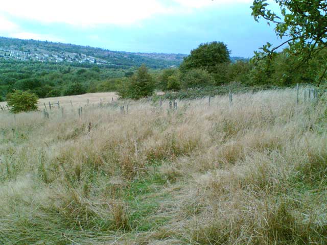
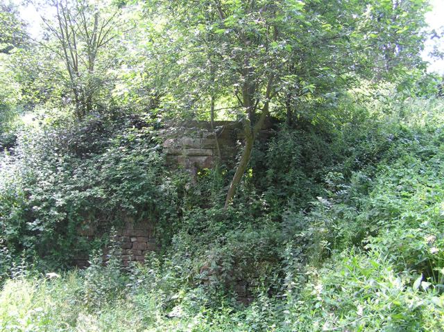
Wickfield Plantation, located in Derbyshire, England, is a picturesque woodland area known for its lush greenery and serene atmosphere. Stretching across a vast expanse, the plantation is a haven for nature enthusiasts and those seeking solace in the midst of nature's beauty.

This woodland paradise offers a diverse range of trees, predominantly consisting of oak, beech, and pine, which create a stunning tapestry of colors throughout the seasons. The forest floor is adorned with a variety of wildflowers and ferns, enhancing the plantation's enchanting aura.

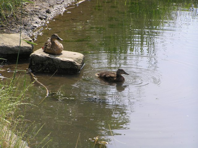
Wickfield Plantation is home to numerous species of wildlife, including deer, foxes, and a plethora of bird species, making it a prime spot for birdwatchers and wildlife enthusiasts. The peaceful ambiance is often punctuated by the melodious songs of the birds, creating a symphony of sounds that can be heard echoing through the trees.

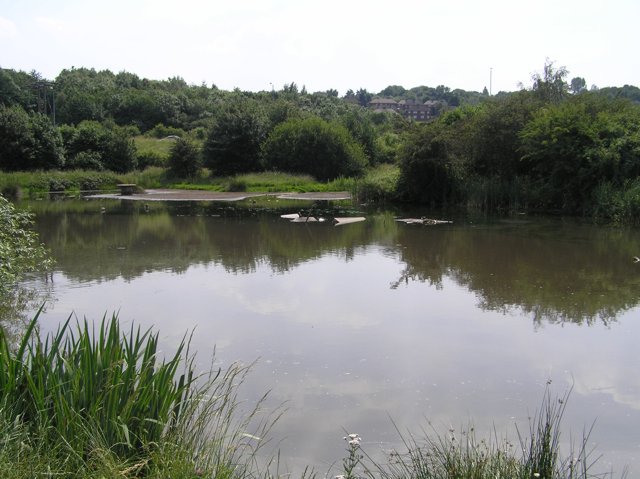
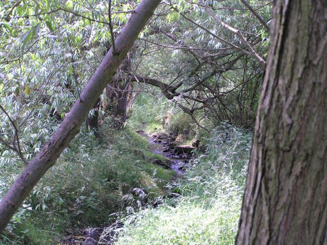
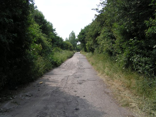
The plantation offers a network of well-maintained footpaths, allowing visitors to explore its beauty at their own pace. These trails wind through the woodland, leading to hidden groves, tranquil ponds, and breathtaking viewpoints. The diverse topography of the area, with its gentle slopes and meandering streams, adds to the charm of Wickfield Plantation.

Furthermore, the plantation houses a small visitor center where visitors can learn more about the local flora and fauna, as well as the history and conservation efforts in place to protect this natural wonder. Guided tours are available for those who wish to delve deeper into the plantation's rich heritage.

Wickfield Plantation, with its idyllic setting and abundance of natural wonders, is truly a sanctuary for those seeking solace in nature's embrace.

If you have any feedback on the listing, please let us know in the comments section below.

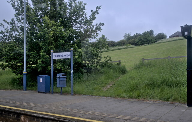
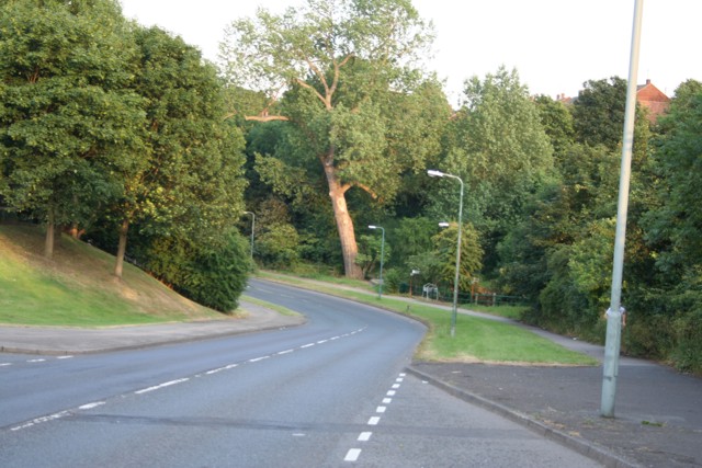
Wickfield Plantation Images

Images are sourced within 2km of 53.353565/-1.3933576 or Grid Reference SK4084. Thanks to Geograph Open Source API. All images are credited.

Hackenthorpe tram stop
Entrance path to Woodhouse Health Centre
Shirebrook Nature Reserve taken at Shirebrook Nature Reserve, near the Visitor Centre
Shirebrook Nature Reserve
taken at Shirebrook Nature Reserve, near the Visitor Centre
Shirebrook Nature Reserve Photo taken on the path outside the Visitor Centre.
Shirebrook Nature Reserve
Photo taken on the path outside the Visitor Centre.
Shirebrook Nature Reserve At Sally Clarke's Meadow looking east.
Shirebrook Nature Reserve
At Sally Clarke's Meadow looking east.
Transpennine Trail By the Transppennine Trail at Sally Clarke's Meadow, Shirebrook Nature Reserve.
Transpennine Trail
By the Transppennine Trail at Sally Clarke's Meadow, Shirebrook Nature Reserve.
Shops, Beighton Road, Woodhouse At the top of Beighton Road in Woodhouse stands a row of shops. The road down to the left goes past the railway station and on down to Woodhouse Mill.
Shops, Beighton Road, Woodhouse
At the top of Beighton Road in Woodhouse stands a row of shops. The road down to the left goes past the railway station and on down to Woodhouse Mill.
South Yorkshire Fire Training School Formerly St John Fisher RC Secondary School back when I were a lad (1970's / 80s), this is now the training centre for South Yorkshire Fire and Rescue. The centre is on Beaver Hill Road between Handsworth and Woodhouse.
South Yorkshire Fire Training School
Formerly St John Fisher RC Secondary School back when I were a lad (1970's / 80s), this is now the training centre for South Yorkshire Fire and Rescue. The centre is on Beaver Hill Road between Handsworth and Woodhouse.
Beaver Hill Road, Woodhouse From outside the fire service training centre <a href="https://www.geograph.org.uk/photo/193087">SK4185 : South Yorkshire Fire Training School</a>, this image looks down Beaver Hill Road towards Woodhouse. In the bottom, just visible is the bridge crossing Shirtcliff Brook.
Beaver Hill Road, Woodhouse
From outside the fire service training centre SK4185 : South Yorkshire Fire Training School, this image looks down Beaver Hill Road towards Woodhouse. In the bottom, just visible is the bridge crossing Shirtcliff Brook.
Carr Forge Dam In the Shirebrook Valley below Woodhouse were several waterwheels, possibly dating back to Tudor times, and part of Sheffield's early industrial heritage. This shows Carr Forge Dam with the water levels lower than usual because of the prolonged dry spell. The Shire Brook was in times past the border between the ancient kingdoms of Mercia and Northumbria and more lately between Yorkshire and Derbyshire, hence the name Shire Brook.
Carr Forge Dam
In the Shirebrook Valley below Woodhouse were several waterwheels, possibly dating back to Tudor times, and part of Sheffield's early industrial heritage. This shows Carr Forge Dam with the water levels lower than usual because of the prolonged dry spell. The Shire Brook was in times past the border between the ancient kingdoms of Mercia and Northumbria and more lately between Yorkshire and Derbyshire, hence the name Shire Brook.
Shire Brook In the Shirebrook Valley, the brook itself fed several waterwheels in times past including <a href="https://www.geograph.org.uk/photo/194486">SK4184 : Carr Forge Dam</a>.
Shire Brook
In the Shirebrook Valley, the brook itself fed several waterwheels in times past including SK4184 : Carr Forge Dam.
Stone Lane, Woodhouse This road once served the sewage works and Badger Tools. Both have now gone, but the sewage works buildings have been converted into buildings for the Shirebrook Valley Nature Reserve. The end of the road (behind me) seems to be a place where old cars go to die, or be burned out by the local yoofs. The speed ramps are probably there to stop the yoofs damaging themselves too much when the cars are crashed into the gates at the end.
Stone Lane, Woodhouse
This road once served the sewage works and Badger Tools. Both have now gone, but the sewage works buildings have been converted into buildings for the Shirebrook Valley Nature Reserve. The end of the road (behind me) seems to be a place where old cars go to die, or be burned out by the local yoofs. The speed ramps are probably there to stop the yoofs damaging themselves too much when the cars are crashed into the gates at the end.
Ducks on Carr Forge Dam Since a youngster nearly killed himself when his fishing pole touched overhead live wires a few years ago, fishing on the dam has been banned by order of Sheffield Council, so the ducks have free rein. Here, mummy-duck sits on the stone keeping an eye on youngster. As I cycled past, another five of this year's brood appeared out from under the shelter of the bank.
Ducks on Carr Forge Dam
Since a youngster nearly killed himself when his fishing pole touched overhead live wires a few years ago, fishing on the dam has been banned by order of Sheffield Council, so the ducks have free rein. Here, mummy-duck sits on the stone keeping an eye on youngster. As I cycled past, another five of this year's brood appeared out from under the shelter of the bank.
Houses on Scowerdons estate Can't really say much more. This is the bottom end of Hackenthorpe, the opposite side of the Shirebrook Valley to Woodhouse and Beighton.
Houses on Scowerdons estate
Can't really say much more. This is the bottom end of Hackenthorpe, the opposite side of the Shirebrook Valley to Woodhouse and Beighton.
Remains of Nether Wheel, Woodhouse Along with <a href="https://www.geograph.org.uk/photo/194486">SK4184 : Carr Forge Dam</a>, the Nether Wheel was yet another of the waterwheels along the Shirebrook Valley. This one still has visible remains of the buildings, buried in woodland although accessible by waymarked footpaths. This wheel probably drove grinding stones or similar for the manufacture of agricultural tools.
Remains of Nether Wheel, Woodhouse
Along with SK4184 : Carr Forge Dam, the Nether Wheel was yet another of the waterwheels along the Shirebrook Valley. This one still has visible remains of the buildings, buried in woodland although accessible by waymarked footpaths. This wheel probably drove grinding stones or similar for the manufacture of agricultural tools.
Silkstone Road, Hackenthorpe One of the many newer roads in the area, certainly not appearing on the 1940's map.
Silkstone Road, Hackenthorpe
One of the many newer roads in the area, certainly not appearing on the 1940's map.
Communications mast, Birley It's a communications mast. It's accessed from a short lane called Dent Lane off Birley Lane. The latter is part of the tram route from Halfway into Sheffield.
Communications mast, Birley
It's a communications mast. It's accessed from a short lane called Dent Lane off Birley Lane. The latter is part of the tram route from Halfway into Sheffield.
Tram crossing / road junction, Birley Lane To the left is Birley Lane. To the right is Sheffield Road. Straight on up is Birley Moor Road and down behind me is Moor Valley. The tram route to the right heads towards Crystal Peaks and the ultimate terminus at Halfway. To the left (west) it heads up past Birley Golf Course, on to the Manor Top and down into Sheffield.
Tram crossing / road junction, Birley Lane
To the left is Birley Lane. To the right is Sheffield Road. Straight on up is Birley Moor Road and down behind me is Moor Valley. The tram route to the right heads towards Crystal Peaks and the ultimate terminus at Halfway. To the left (west) it heads up past Birley Golf Course, on to the Manor Top and down into Sheffield.
Show me another place!

Wickfield Plantation is located at Grid Ref: SK4084 (Lat: 53.353565, Lng: -1.3933576)

Unitary Authority: Sheffield

Police Authority: South Yorkshire

What 3 Words

///strain.casual.bless. Near Orgreave, South Yorkshire

Related Wikis

Normanton Spring

Normanton Spring (according to Ordnance Survey maps), also called Normanton Springs, is a suburb and former hamlet located 4 miles east of Sheffield's...

Outwood Academy City

Outwood Academy City is a co-educational secondary school with academy status located on Stradbroke Road in Sheffield, South Yorkshire, England.The school...

Birley Spa

Birley Spa is a grade-II listed community bath hall and a Victorian bathhouse in the Hackenthorpe district of the City of Sheffield, England. == History... ==

Frecheville

Frecheville is a suburb five miles (8.0 km) south-east of Sheffield’s city centre. The estate was built in the 1930s when the area was in Derbyshire. However...

Nearby Amenities

Located within 500m of 53.353565,-1.3933576
Normanton Springs
Is In: South Yorkshire, England, UK
Place: neighbourhood
Lat/Long: 53.3558905/-1.3919943
Bus Stop
Wickfield Road/Silkstone Road
Bench: no
Bin: no
Bus: yes
Departures Board: timetable
Naptan AtcoCode: 370021564
Naptan Bearing: N
Naptan CommonName: Wickfield Road/Silkstone Road
Naptan Indicator: 21564
Naptan Landmark: Rows of Houses
Naptan PlusbusZoneRef: ROTHCEN
Naptan Street: Wickfield Road
Naptan Verified: no
Operator: First South Yorkshire
Public Transport: platform
Ref: 37021564
Shelter: no
Source: naptan_import
Tactile Paving: no
Lat/Long: 53.3510517/-1.3908164
Bus Stop
Silkstone Road/Dyke Vale Road
Alt Name: Silkstone Road/Dyke Vale Road
Bus: yes
Naptan AltCommonName: Silkstone Road/Dyke Vale Road
Naptan AtcoCode: 370021567
Naptan Bearing: SW
Naptan CommonName: Silkstone Road/Dyke Vale Road
Naptan Indicator: 21567
Naptan Landmark: Opposite Rows of Houses
Naptan PlusbusZoneRef: ROTHCEN
Naptan Street: Silkstone Road
Naptan Verified: no
Public Transport: platform
Source: naptan_import
Lat/Long: 53.3507307/-1.3878163
Bus Stop
Silkstone Road/Wickfield Grove
Bus: yes
Departures Board: timetable
Naptan AtcoCode: 370021568
Naptan Bearing: E
Naptan CommonName: Silkstone Road/Wickfield Grove
Naptan Indicator: 21568
Naptan Landmark: Jack In A Box
Naptan PlusbusZoneRef: ROTHCEN
Naptan Street: Silkstone Road
Naptan Verified: no
Operator: First South Yorkshire, TM Travel
Public Transport: platform
Ref: 37021568
Shelter: no
Source: naptan_import
Lat/Long: 53.3502749/-1.3927765
Bus Stop
Silkstone Road/Wickfield Grove
Bus: yes
Departures Board: timetable
Naptan AtcoCode: 370021569
Naptan Bearing: W
Naptan CommonName: Silkstone Road/Wickfield Grove
Naptan Indicator: 21569
Naptan Landmark: Opposite Jack In A Box
Naptan PlusbusZoneRef: ROTHCEN
Naptan Street: Silkstone Road
Naptan Verified: no
Operator: First South Yorkshire, TM Travel
Public Transport: platform
Ref: 37021569
Shelter: yes
Source: naptan_import
Lat/Long: 53.3502145/-1.3925499
Bus Stop
Silkstone Road/Alport Avenue
Bus: yes
Naptan AtcoCode: 370021570
Naptan Bearing: SE
Naptan CommonName: Silkstone Road/Alport Avenue
Naptan Indicator: 21570
Naptan Landmark: Opposite Set Back Houses
Naptan PlusbusZoneRef: ROTHCEN
Naptan Street: Silkstone Road
Naptan Verified: no
Public Transport: platform
Source: naptan_import
Lat/Long: 53.3501642/-1.3965978
Bus Stop
Silkstone Road/Alport Avenue
Bus: yes
Naptan AtcoCode: 370021571
Naptan Bearing: NW
Naptan CommonName: Silkstone Road/Alport Avenue
Naptan Indicator: 21571
Naptan Landmark: Road Junction
Naptan PlusbusZoneRef: ROTHCEN
Naptan Street: Silkstone Road
Naptan Verified: no
Public Transport: platform
Shelter: yes
Source: naptan_import
Lat/Long: 53.3501683/-1.397409
Bus Stop
Wickfield Road/Dyke Vale Road
Bench: no
Bin: no
Bus: yes
Naptan AtcoCode: 370021594
Naptan Bearing: NE
Naptan CommonName: Wickfield Road/Dyke Vale Road
Naptan Indicator: 21594
Naptan Landmark: OPPOSITE NO. 110
Naptan PlusbusZoneRef: ROTHCEN
Naptan Street: Wickfield Road
Naptan Verified: no
Public Transport: platform
Shelter: no
Source: naptan_import
Tactile Paving: no
Lat/Long: 53.3528658/-1.39049
Bus Stop
Dyke Vale Road/Spa Brook Drive
Bench: no
Bin: yes
Bus: yes
Departures Board: timetable
Naptan AtcoCode: 370021597
Naptan Bearing: N
Naptan CommonName: Dyke Vale Road/Spa Brook Drive
Naptan Indicator: 21597
Naptan Landmark: Post Box
Naptan PlusbusZoneRef: ROTHCEN
Naptan Street: Dyke Vale Road
Naptan Verified: no
Operator: First South Yorkshire
Public Transport: platform
Shelter: yes
Source: naptan_import
Tactile Paving: no
Lat/Long: 53.3523959/-1.3882432
Bus Stop
Dyke Vale Road/Normanton Spring Road
Alt Name: Dyke Vale Road/Normanton Spring Road
Bus: yes
Naptan AltCommonName: Dyke Vale Road/Normanton Spring Road
Naptan AtcoCode: 370021598
Naptan Bearing: N
Naptan CommonName: Dyke Vale Road/Normanton Spring Road
Naptan Indicator: 21598
Naptan Landmark: Road Junction
Naptan PlusbusZoneRef: ROTHCEN
Naptan Street: Dyke Vale Road
Naptan Verified: no
Public Transport: platform
Source: naptan_import
Lat/Long: 53.3551187/-1.3898269
Bus Stop
Coisley Hill/Dyke Vale Road
Alt Name: Coisley Hill/Dyke Vale Road
Bus: yes
Naptan AltCommonName: Coisley Hill/Dyke Vale Road
Naptan AtcoCode: 370021599
Naptan Bearing: E
Naptan CommonName: Coisley Hill/Dyke Vale Road
Naptan Indicator: 21599
Naptan Landmark: Traffic Island
Naptan PlusbusZoneRef: ROTHCEN
Naptan Street: Normanton Spring Road
Naptan Verified: no
Public Transport: platform
Source: naptan_import
Lat/Long: 53.3558715/-1.3893954
Bus Stop
Normanton Spring Road/Normanton Grove
Bus: yes
Naptan AtcoCode: 370021600
Naptan Bearing: W
Naptan CommonName: Normanton Spring Road/Normanton Grove
Naptan Indicator: 21600
Naptan Landmark: Road Junction
Naptan PlusbusZoneRef: ROTHCEN
Naptan Street: Normanton Spring Road
Naptan Verified: no
Public Transport: platform
Shelter: yes
Source: naptan_import
Lat/Long: 53.3556541/-1.3908259
Bus Stop
Normanton Spring Road/Carlin Street
Bus: yes
Naptan AtcoCode: 370021601
Naptan Bearing: N
Naptan CommonName: Normanton Spring Road/Carlin Street
Naptan Indicator: 21601
Naptan Landmark: 21601
Naptan PlusbusZoneRef: ROTHCEN
Naptan Street: Normanton Spring Road
Naptan Verified: no
Public Transport: platform
Source: naptan_import
Lat/Long: 53.3557423/-1.3940249
Bus Stop
Normanton Spring Road/Linley Lane
Alt Name: Normanton Spring Road/Linley Lane
Bus: yes
Naptan AltCommonName: Normanton Spring Road/Linley Lane
Naptan AtcoCode: 370021602
Naptan Bearing: N
Naptan CommonName: Normanton Spring Road/Linley Lane
Naptan Indicator: 21602
Naptan Landmark: O/S NORMANTON SPRING PUB/OPP.
Naptan PlusbusZoneRef: ROTHCEN
Naptan Street: Normanton Spring Road
Naptan Verified: no
Public Transport: platform
Source: naptan_import
Lat/Long: 53.3555573/-1.3947637
Turning Circle
Source: Bing
Lat/Long: 53.3504824/-1.3943588
Turning Circle
Spa Brook Close
Source: GPS
Lat/Long: 53.3508607/-1.3896782
Turning Circle
Source: Bing
Lat/Long: 53.3512754/-1.3940027
Turning Circle
Source: Bing
Lat/Long: 53.3538628/-1.3889443
Turning Circle
Source: Bing
Lat/Long: 53.3566842/-1.3917746
Turning Circle
Source: Bing
Lat/Long: 53.3560454/-1.3935073
Turning Circle
Source: Bing
Lat/Long: 53.3565289/-1.3906883
Crossing
Crossing: unmarked
Crossing Island: no
Kerb: lowered
Tactile Paving: no
Lat/Long: 53.3521085/-1.3873297
Crossing
Crossing: unmarked
Crossing Island: no
Kerb: lowered
Tactile Paving: no
Lat/Long: 53.3526916/-1.388824
Barrier: kissing_gate
Lat/Long: 53.3556783/-1.3914529
Turning Circle
Source: Bing
Lat/Long: 53.3534704/-1.4003615
Barrier: kissing_gate
Lat/Long: 53.3540397/-1.390691
Turning Circle
Source: Bing
Lat/Long: 53.3519004/-1.395964
Turning Circle
Source: Bing
Lat/Long: 53.3509254/-1.3953229
Barrier: kissing_gate
Lat/Long: 53.3524998/-1.3938076
Noexit: yes
Lat/Long: 53.3549866/-1.3881543
Crossing
Crossing: unmarked
Crossing Island: no
Kerb: lowered
Tactile Paving: no
Lat/Long: 53.3503757/-1.3892292
Kerb: raised
Lat/Long: 53.3528967/-1.3884778
Kerb: raised
Lat/Long: 53.3522771/-1.388143
Barrier: motorcycle_barrier
Lat/Long: 53.3497392/-1.3946736
Barrier: motorcycle_barrier
Lat/Long: 53.3501829/-1.3930145
Barrier: motorcycle_barrier
Lat/Long: 53.3500584/-1.3910908
Post Box
Collection Times: Mo-Fr 09:00; Sa 07:00
Post Box Type: pillar
Ref: S12 801D
Royal Cypher: EIIR
Royal Cypher Wikidata: Q33102113
Lat/Long: 53.3520898/-1.3974033
Post Box
Collection Times: Mo-Fr 09:00; Sa 07:00
Post Box Type: pillar
Ref: S12 967D
Royal Cypher: EIIR
Royal Cypher Wikidata: Q33102113
Lat/Long: 53.3501368/-1.3907385
Post Box
Collection Times: Mo-Fr 09:00; Sa 07:00
Post Box Type: pillar
Ref: S12 1020
Royal Cypher: EIIR
Royal Cypher Wikidata: Q33102113
Lat/Long: 53.3522194/-1.3881472
Post Box
Collection Times: Mo-Fr 09:00; Sa 07:00
Post Box Type: pillar
Ref: S13 163
Royal Cypher: EIIR
Royal Cypher Wikidata: Q33102113
Lat/Long: 53.3557885/-1.3925208
Barrier: kissing_gate
Lat/Long: 53.3551138/-1.3951513
Bench
Backrest: yes
Lat/Long: 53.3542257/-1.3945931
Barrier: kissing_gate
Lat/Long: 53.3549953/-1.396813
Ford: yes
Lat/Long: 53.3540111/-1.3917507
Bench
Backrest: yes
Lat/Long: 53.3543399/-1.3970779
Bench
Backrest: no
Lat/Long: 53.3536078/-1.3937703
Bus Stop
Dyke Vale Road/Spa Brook Drive
Bench: no
Bin: no
Bus: yes
Departures Board: no
Naptan AtcoCode: 370027424
Naptan NaptanCode: 37027424
Operator: First South Yorkshire
Public Transport: platform
Shelter: no
Tactile Paving: no
Lat/Long: 53.352488/-1.388789
Grit Bin
Operator: Sheffield City Council
Operator Type: government
Operator Wikidata: Q7492609
Seasonal: no
Lat/Long: 53.3500215/-1.3910041
Grit Bin
Operator: Sheffield City Council
Operator Type: government
Operator Wikidata: Q7492609
Seasonal: no
Lat/Long: 53.3524033/-1.3980459
Grit Bin
Operator: Sheffield City Council
Operator Type: government
Operator Wikidata: Q7492609
Seasonal: no
Lat/Long: 53.3563293/-1.3923414
Grit Bin
Operator: Sheffield City Council
Operator Type: government
Operator Wikidata: Q7492609
Seasonal: no
Lat/Long: 53.3534974/-1.3975498
Grit Bin
Operator: Sheffield City Council
Operator Type: government
Operator Wikidata: Q7492609
Seasonal: no
Lat/Long: 53.3537645/-1.4006108
Grit Bin
Operator: Sheffield City Council
Operator Type: government
Operator Wikidata: Q7492609
Seasonal: no
Lat/Long: 53.3555379/-1.3958082
The data included in this document is from www.openstreetmap.org. The data is made available under ODbL.

Have you been to Wickfield Plantation?

Leave your review of Wickfield Plantation below (or comments, questions and feedback).