Cleveland Gorse
Wood, Forest in Durham
England
Cleveland Gorse

Cleveland Gorse, located in Durham, England, is a beautiful wooded area known for its rich forest and abundant wildlife. It is situated on the eastern edge of the Cleveland Hills, offering visitors a peaceful and serene environment to explore and connect with nature.
Covering an area of approximately 200 hectares, Cleveland Gorse is predominantly made up of mature mixed woodland, including species such as oak, beech, ash, and birch. These trees create a dense canopy, providing shade and shelter for a diverse range of flora and fauna.
The forest floor is adorned with an array of wildflowers, ferns, and mosses, creating a vibrant and colorful undergrowth. Among the notable plants found in Cleveland Gorse are bluebells, wood anemones, and primroses, which bloom in spring, transforming the forest into a picturesque scene.
The woodland is also home to a variety of wildlife. Birdwatchers can spot species such as woodpeckers, nuthatches, and tawny owls, while mammal enthusiasts may encounter roe deer, badgers, and foxes. The presence of a small stream running through the woods adds to the diverse ecosystem, attracting amphibians like frogs and newts.
Cleveland Gorse is a popular destination for nature lovers, hikers, and photographers, offering numerous trails and paths for exploration. Visitors can enjoy peaceful walks, picnics, and even camping in designated areas. The forest is well-maintained, with clear signposts and information boards to help navigate the area.
Overall, Cleveland Gorse in Durham is a hidden gem, providing a tranquil and enchanting woodland experience for all who venture into its depths.
If you have any feedback on the listing, please let us know in the comments section below.
Cleveland Gorse Images
Images are sourced within 2km of 54.70915/-1.4145444 or Grid Reference NZ3735. Thanks to Geograph Open Source API. All images are credited.


Cleveland Gorse is located at Grid Ref: NZ3735 (Lat: 54.70915, Lng: -1.4145444)
Unitary Authority: County Durham
Police Authority: Durham
What 3 Words
///readers.unusually.laces. Near Trimdon Grange, Co. Durham
Nearby Locations
Related Wikis

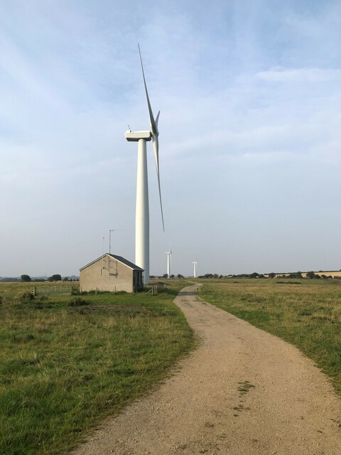
Trimdon Grange Wind Farm
Trimdon Grange Wind Farm is an onshore wind farm near Trimdon Grange, County Durham, England. Commissioned in October 2008 it consists of four 1.3 MW Nordex...
Charity Land
Charity Land is a Site of Special Scientific Interest in the Sedgefield district of County Durham, England. It covers an area on both banks of the River...
Trimdon Colliery
Trimdon Colliery is a village in County Durham, in England. It is situated a few miles to the west of Hartlepool, and a short distance to the north of...
Trimdon Grange
Trimdon Grange is a village in County Durham, in England. It is situated ten miles to the west of Hartlepool, and a short distance to the north of Trimdon...
Trimdon railway station
Trimdon railway station served the village of Trimdon, County Durham, England, from 1871 to 1952 on the Great North of England, Clarence and Hartlepool...
Trimdon
Trimdon is a village in County Durham, in England, previously known as Tremeldon (1196) or Tremedon (1262).It is 9 miles west of Hartlepool, and adjacent...
Trimdon Labour Club
Trimdon Labour Club was a bar and local branch of Sedgefield Labour Party in the village of Trimdon, County Durham in England. It opened in 1993, as a...
Deaf Hill
Deaf Hill is a village in County Durham, England. It is situated a short distance to the east of Trimdon Colliery. The origin of the name is not known...
Nearby Amenities
Located within 500m of 54.70915,-1.4145444Have you been to Cleveland Gorse?
Leave your review of Cleveland Gorse below (or comments, questions and feedback).