Barrows Orchard Copse
Wood, Forest in Hampshire New Forest
England
Barrows Orchard Copse

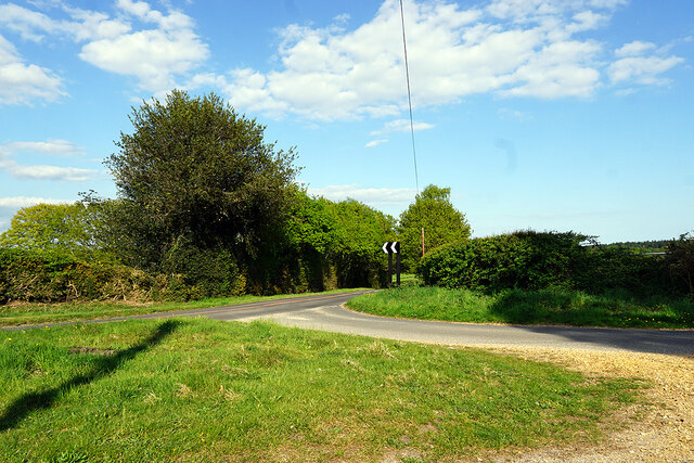
Barrows Orchard Copse is a charming woodland located in the county of Hampshire, England. Stretching across an area of approximately 50 acres, this picturesque forest is a haven for nature enthusiasts and those seeking tranquility amidst the bustling urban life.
The copse is predominantly composed of native broadleaf trees such as oak, beech, and birch, which create a dense canopy overhead, providing shade and shelter for a myriad of wildlife. The forest floor is adorned with a vibrant carpet of wildflowers, ferns, and mosses, adding to the enchanting atmosphere.
Dotted throughout the copse are several well-maintained walking trails, allowing visitors to explore the woodland at their own pace. The paths wind through the forest, meandering beside babbling brooks and picturesque ponds, offering glimpses of the abundant flora and fauna that call this place home.
Birdwatchers will be delighted by the variety of avian species that inhabit the copse. From the melodious songs of the blackbird to the distinctive calls of the great spotted woodpecker, the forest is alive with the sounds of nature.
Barrows Orchard Copse is also home to a rich biodiversity, hosting an array of mammals such as foxes, badgers, and deer, as well as a diverse insect population. The forest provides a vital habitat for these creatures, supporting their survival and contributing to the overall health of the ecosystem.
Visitors to Barrows Orchard Copse can expect a serene and immersive experience, where they can reconnect with nature and revel in the beauty of this captivating woodland.
If you have any feedback on the listing, please let us know in the comments section below.
Barrows Orchard Copse Images
Images are sourced within 2km of 50.883971/-1.4688191 or Grid Reference SU3709. Thanks to Geograph Open Source API. All images are credited.


Barrows Orchard Copse is located at Grid Ref: SU3709 (Lat: 50.883971, Lng: -1.4688191)
Administrative County: Hampshire
District: New Forest
Police Authority: Hampshire
What 3 Words
///part.gold.film. Near Marchwood, Hampshire
Related Wikis

Staplewood Campus
Staplewood Campus in Marchwood, Hampshire is the training ground of Southampton Football Club. It was the home ground of Road-Sea Southampton until 1987...
Southampton F.C. Under-21s and Academy
Southampton F.C. Under-21s and Academy or Saints U21s and Academy is the youth organisation run by Southampton F.C. to encourage and develop young footballers...

Marchwood railway station
Marchwood railway station was an intermediate station on the Totton, Hythe and Fawley Light Railway, which was built along the coast of Southampton Water...

Marchwood
Marchwood is a village and civil parish located in Hampshire, England. It lies between Totton and Hythe on the western shore of Southampton Water and directly...

New Forest Wildlife Park
The New Forest Wildlife Park (formerly The New Forest Otter, Owl and Wildlife Conservation Park) is located on the edge of The New Forest close to the...
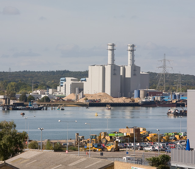
Marchwood Power Station
Marchwood Power Station is an 898.1 MW gas-fired power station in Marchwood, near Southampton, England. It is situated beside estuary of the River Test...
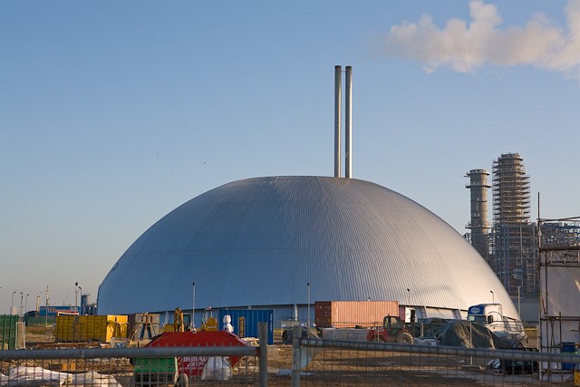
Marchwood ERF
Marchwood ERF (or Marchwood Energy Recovery Facility) is a waste incineration plant in Marchwood, near Southampton, England. It is situated beside the...

Eling and Bury Marshes
Eling and Bury Marshes is a 112.3-hectare (277-acre) biological Site of Special Scientific Interest between Totton and Southampton in Hampshire. It is...
Nearby Amenities
Located within 500m of 50.883971,-1.4688191Have you been to Barrows Orchard Copse?
Leave your review of Barrows Orchard Copse below (or comments, questions and feedback).