Church Coppice

Wood, Forest in Warwickshire Stratford-on-Avon

England

Church Coppice

Chesterton Mill A wintery sunset on Windmill Hill
Chesterton Mill Credit: Rod Davidson

Church Coppice is a small woodland area located in Warwickshire, England. Situated near the town of Wood, this forested area spans approximately 10 acres and is known for its natural beauty and tranquility. The name "Coppice" refers to the practice of periodically cutting back trees to stimulate new growth, indicating that this woodland has likely been managed for centuries.

The forest is characterized by a mix of deciduous and coniferous trees, creating a diverse and vibrant landscape throughout the seasons. Oak, beech, and birch trees dominate the area, providing a dense canopy that shelters a variety of wildlife. Walking through the woods, visitors can expect to encounter an array of flora and fauna, including wildflowers, ferns, squirrels, and songbirds.

Church Coppice is also home to a small stream that meanders through the woodland, adding to its picturesque charm. The gurgling sound of running water and the dappled sunlight filtering through the trees create a peaceful ambiance, making it a popular spot for nature enthusiasts, hikers, and photographers.

The forest offers several footpaths and trails, allowing visitors to explore its natural wonders at their leisure. These paths are well-maintained and clearly marked, ensuring a safe and enjoyable experience for all. Additionally, there are picnic areas and benches scattered throughout the woodland, providing opportunities for relaxation and contemplation.

Overall, Church Coppice in Warwickshire is a hidden gem that offers a serene escape from the hustle and bustle of daily life. Its natural beauty, diverse wildlife, and well-preserved trails make it a must-visit destination for anyone seeking a peaceful retreat in the heart of England.

If you have any feedback on the listing, please let us know in the comments section below.

Church Coppice Images

Images are sourced within 2km of 52.222946/-1.4772701 or Grid Reference SP3558. Thanks to Geograph Open Source API. All images are credited.

Chesterton Mill A wintery sunset on Windmill Hill
Chesterton Mill
A wintery sunset on Windmill Hill
Electric chargers, Warwick services (M40 South)
Bush Heath Lane, Harbury
Harbury, Temple End
Harbury, Temple End
Temple End, Harbury
Temple End, Harbury
Chesterton Road
Chesterton Road
Chesterton Windmill Grade I-listed windmill, dating from 1682 (Historic England List Entry Number:1300056 <span class="nowrap"><a title="https://historicengland.org.uk/listing/the-list/list-entry/1300056?section=official-list-entry" rel="nofollow ugc noopener" href="https://historicengland.org.uk/listing/the-list/list-entry/1300056?section=official-list-entry">Link</a><img style="margin-left:2px;" alt="External link" title="External link - shift click to open in new window" src="https://s1.geograph.org.uk/img/external.png" width="10" height="10"/></span> ); it was associated with Chesterton House which was demolished in 1802. The current machinery dates from 1860 and was used until about 1910 before gradually becoming derelict. The mill was restored to working order between 1965 and 1974 and is now owned by Warwickshire County Council.

The windmill no longer has its sails, see <a href="https://www.geograph.org.uk/photo/4950975">SP3459 : Chesterton Windmill</a> for an earlier (2016) photograph complete with its sails.
Chesterton Windmill
Grade I-listed windmill, dating from 1682 (Historic England List Entry Number:1300056 LinkExternal link ); it was associated with Chesterton House which was demolished in 1802. The current machinery dates from 1860 and was used until about 1910 before gradually becoming derelict. The mill was restored to working order between 1965 and 1974 and is now owned by Warwickshire County Council. The windmill no longer has its sails, see SP3459 : Chesterton Windmill for an earlier (2016) photograph complete with its sails.
Windmill Hill Lane, Chesterton Green
Chesterton Windmill and Windmill Hill The picture was taken over a field gate during a sunny spell early on a showery April evening. The limestone tower dates from 1632 - for more about it, try <span class="nowrap"><a title="http://www2.warwick.ac.uk/fac/sci/moac/people/students/peter_cock/photos/chesterton_windmill/" rel="nofollow ugc noopener" href="http://www2.warwick.ac.uk/fac/sci/moac/people/students/peter_cock/photos/chesterton_windmill/">Link</a><img style="margin-left:2px;" alt="External link" title="External link - shift click to open in new window" src="https://s1.geograph.org.uk/img/external.png" width="10" height="10"/></span> .
Chesterton Windmill and Windmill Hill
The picture was taken over a field gate during a sunny spell early on a showery April evening. The limestone tower dates from 1632 - for more about it, try LinkExternal link .
Chesterton Windmill The picture was taken over a field gate during a sunny spell early on a showery April evening. The limestone tower dates from 1632 - for more about it, try <span class="nowrap"><a title="http://www2.warwick.ac.uk/fac/sci/moac/people/students/peter_cock/photos/chesterton_windmill/" rel="nofollow ugc noopener" href="http://www2.warwick.ac.uk/fac/sci/moac/people/students/peter_cock/photos/chesterton_windmill/">Link</a><img style="margin-left:2px;" alt="External link" title="External link - shift click to open in new window" src="https://s1.geograph.org.uk/img/external.png" width="10" height="10"/></span> .
Chesterton Windmill
The picture was taken over a field gate during a sunny spell early on a showery April evening. The limestone tower dates from 1632 - for more about it, try LinkExternal link .
Up Windmill Hill South Warwickshire early on an April evening.
Up Windmill Hill
South Warwickshire early on an April evening.
Farmland on Windmill Hill
Chesterton Windmill Unusual early windmill constructed in 1632. Open in 2016 for National Mills Weekend but light winds prevented any milling.
Chesterton Windmill
Unusual early windmill constructed in 1632. Open in 2016 for National Mills Weekend but light winds prevented any milling.
Chesterton Mill - Inside the Cap/Dust Floor The working parts of the power system comprise the wind shaft, attached to the sails, fixed to the toothed brake wheel which in turn transfers the drive to the main vertical shaft through the lantern gallery. The top of the main shaft is held in position by the Sprattle Beam.

The mill was open to the public for National Mills Weekend 2016.
Chesterton Mill - Inside the Cap/Dust Floor
The working parts of the power system comprise the wind shaft, attached to the sails, fixed to the toothed brake wheel which in turn transfers the drive to the main vertical shaft through the lantern gallery. The top of the main shaft is held in position by the Sprattle Beam. The mill was open to the public for National Mills Weekend 2016.
Chesterton Mill - Stone Floor The mill has two pairs of stones set on the Hurst or wooden frame about one metre above the floor level. The Spur Wheel and Stone Nuts occupy the space below. The flour is also collected just below the wooden Tun that encases the stones.
Chesterton Mill - Stone Floor
The mill has two pairs of stones set on the Hurst or wooden frame about one metre above the floor level. The Spur Wheel and Stone Nuts occupy the space below. The flour is also collected just below the wooden Tun that encases the stones.
Chesterton Mill - Cap winch The winch allows the whole of the cap, sails and wind shaft to be manually turned into the wind. The wind direction is shown on an indicator at the top of the cap connected to an external weather vane. Later mills incorporated a tail wheel to automatically adjust for wind direction.
Chesterton Mill - Cap winch
The winch allows the whole of the cap, sails and wind shaft to be manually turned into the wind. The wind direction is shown on an indicator at the top of the cap connected to an external weather vane. Later mills incorporated a tail wheel to automatically adjust for wind direction.
Chesterton Mill - Wind direction indicator The whole of the cap, sails and wind shaft had to be manually turned into the wind using a winch. The wind direction is shown on an indicator at the top of the cap connected to an external weather vane. Later mills incorporated a tail wheel to automatically adjust for wind direction.
Chesterton Mill - Wind direction indicator
The whole of the cap, sails and wind shaft had to be manually turned into the wind using a winch. The wind direction is shown on an indicator at the top of the cap connected to an external weather vane. Later mills incorporated a tail wheel to automatically adjust for wind direction.
Chesterton Mill - Lantern Pinion Wallower Unusual detail on the top of the Main Shaft. Normally this would be a toothed wheel.
Chesterton Mill - Lantern Pinion Wallower
Unusual detail on the top of the Main Shaft. Normally this would be a toothed wheel.
Show me another place!

Church Coppice is located at Grid Ref: SP3558 (Lat: 52.222946, Lng: -1.4772701)

Administrative County: Warwickshire

District: Stratford-on-Avon

Police Authority: Warwickshire

What 3 Words

///ties.wrist.visa. Near Harbury, Warwickshire

Related Wikis

Chesterton, Warwickshire

Chesterton is a small village in Warwickshire, England. The population of the civil parish taken at the 2011 census was 123. It is about five miles south...
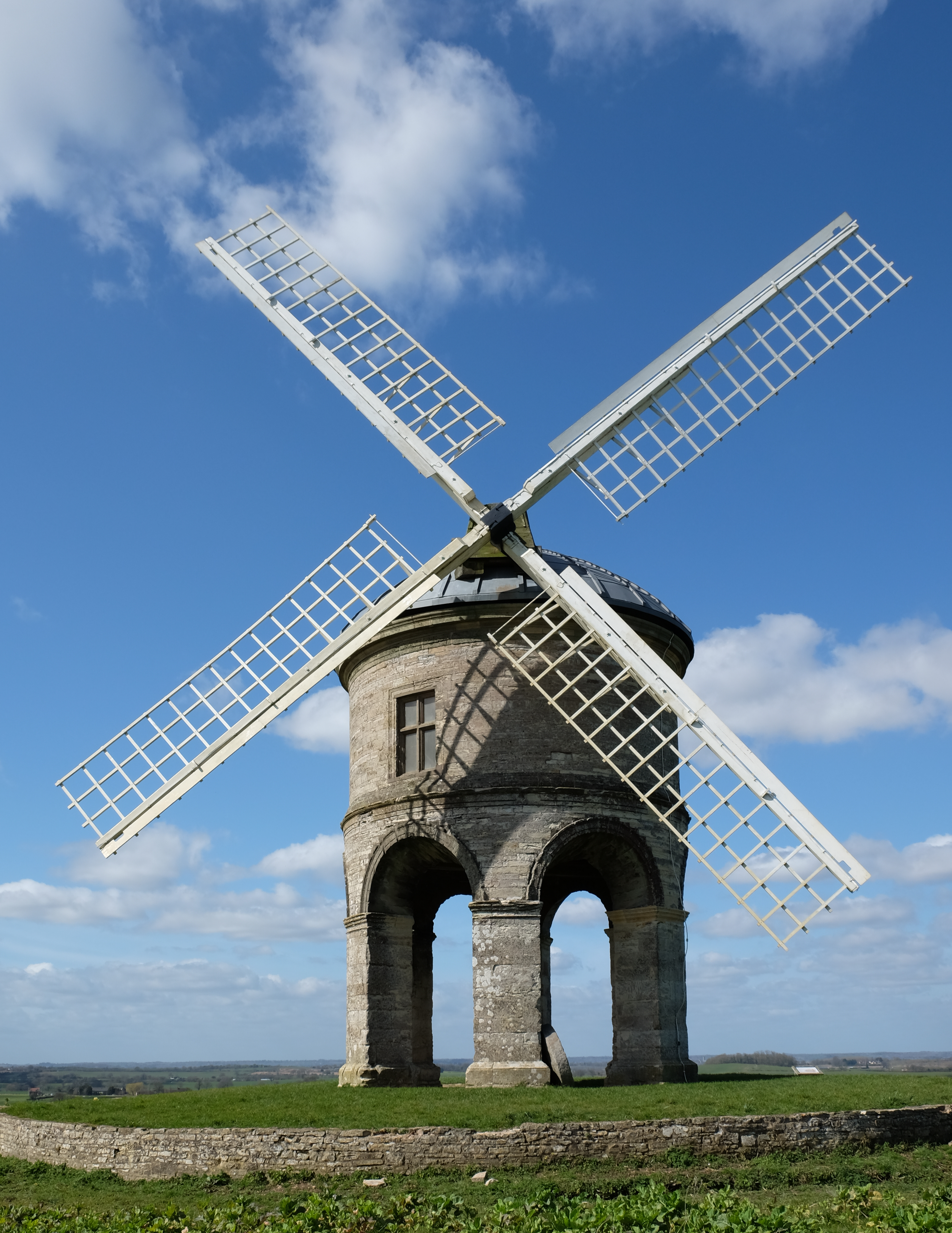
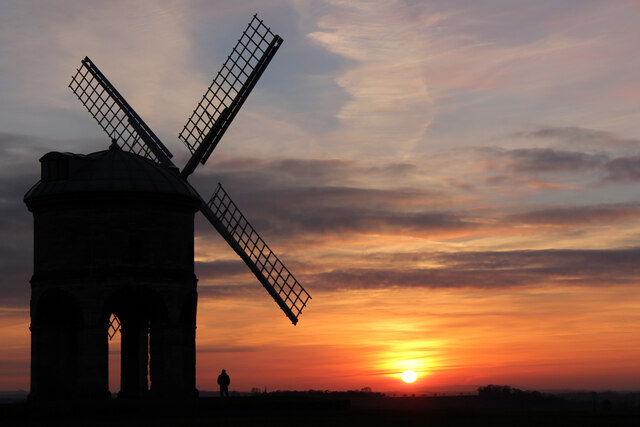
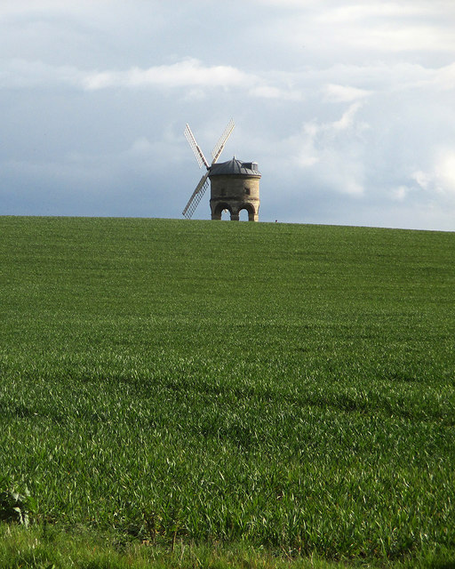
Chesterton Windmill

Chesterton Windmill is a 17th-century cylindric stone tower windmill with an arched base, located outside the village of Chesterton, Warwickshire. It is...

Warwick services

Warwick Services is a motorway service station on the M40 motorway in Warwickshire, England. It is situated approximately 5 miles (8 km) south-east of...

Harbury

Harbury is a village and civil parish in the Stratford-on-Avon district of Warwickshire, England. It is about 3 miles (5 km) west-southwest of Southam...

Lighthorne Heath

Lighthorne Heath is a village in the civil parish of Upper Lighthorne, in the Stratford-on-Avon District, in the county of Warwickshire, England. It is...

Leamington F.C.

Leamington Football Club is a football club based in Leamington Spa, Warwickshire, England. They are currently members of the Southern League Premier Division...

Bishop's Itchington

Bishop's Itchington is a village and civil parish in the Stratford-on-Avon district of Warwickshire, England. It is about 3 miles (5 km) south-southwest...

Lighthorne

Lighthorne is a village and civil parish in Warwickshire, England. It is about 6 miles (9.7 km) south of Leamington Spa. The population taken at the 2011...

Nearby Amenities

Located within 500m of 52.222946,-1.4772701
Peyto Gate
Heritage: 2
Heritage Operator: Historic England
Historic: monument
Listed Status: Grade II*
Source: survey
Lat/Long: 52.2214357/-1.4788276
Barrier: stile
Source: survey
Lat/Long: 52.2223886/-1.4789172
Barrier: stile
Source: bing
Lat/Long: 52.2222723/-1.4789137
Barrier: cattle_grid
Bicycle: yes
Foot: yes
Lat/Long: 52.2195574/-1.4749439
Barrier: stile
Lat/Long: 52.2202457/-1.4773724
Barrier: kissing_gate
Lat/Long: 52.2204766/-1.4771071
The data included in this document is from www.openstreetmap.org. The data is made available under ODbL.

Have you been to Church Coppice?

Leave your review of Church Coppice below (or comments, questions and feedback).