Baron's Quay Wood

Wood, Forest in Durham

England

Baron's Quay Wood

Hylton Castle, Sunderland 18th Century Gatehouse / Tower 

<span class="nowrap"><a title="https://en.wikipedia.org/wiki/Hylton_Castle" rel="nofollow ugc noopener" href="https://en.wikipedia.org/wiki/Hylton_Castle">Link</a><img style="margin-left:2px;" alt="External link" title="External link - shift click to open in new window" src="https://s1.geograph.org.uk/img/external.png" width="10" height="10"/></span>
Hylton Castle, Sunderland Credit: Brian Deegan

Baron's Quay Wood is a picturesque woodland located in Durham, England. Covering an area of approximately 50 acres, it is a popular spot for locals and tourists alike, offering a tranquil escape from the bustling city life. The wood is situated on the banks of the River Wear, adding to its idyllic setting.

The woodland is predominantly composed of native broadleaf trees such as oak, beech, and birch, creating a rich and diverse ecosystem. These trees provide a habitat for a wide range of wildlife, including birds, squirrels, and various insect species. Visitors to the wood can often spot these creatures while exploring the well-maintained paths that meander through the forest.

Baron's Quay Wood offers more than just natural beauty; it also boasts historical significance. The wood is believed to have been part of a medieval deer park, once belonging to the powerful Prince Bishops of Durham. Evidence of this can still be seen in the form of an ancient boundary wall that runs through the woodland.

For outdoor enthusiasts, the wood provides ample opportunities for activities such as walking, jogging, and cycling. There are designated picnic areas where visitors can relax and enjoy a meal surrounded by nature. The wood is also a popular destination for dog walkers, who appreciate the open spaces and peaceful environment.

Overall, Baron's Quay Wood is a charming woodland retreat in Durham, offering a combination of natural beauty, wildlife, and historical significance. Whether seeking a peaceful stroll or an active adventure, visitors are sure to find solace and enjoyment in this enchanting forest.

If you have any feedback on the listing, please let us know in the comments section below.

Baron's Quay Wood Images

Images are sourced within 2km of 54.910843/-1.4507417 or Grid Reference NZ3557. Thanks to Geograph Open Source API. All images are credited.

Hylton Castle, Sunderland 18th Century Gatehouse / Tower 

<span class="nowrap"><a title="https://en.wikipedia.org/wiki/Hylton_Castle" rel="nofollow ugc noopener" href="https://en.wikipedia.org/wiki/Hylton_Castle">Link</a><img style="margin-left:2px;" alt="External link" title="External link - shift click to open in new window" src="https://s1.geograph.org.uk/img/external.png" width="10" height="10"/></span>
Hylton Castle, Sunderland
18th Century Gatehouse / Tower LinkExternal link
Northern Spire Bridge Two span cable-stayed bridge across the river Wear, constructed 2015 - 2018. This new crossing upstream of the Queen Alexandra and Wearmouth bridges was required to reduce traffic congestion in the city.
Northern Spire Bridge
Two span cable-stayed bridge across the river Wear, constructed 2015 - 2018. This new crossing upstream of the Queen Alexandra and Wearmouth bridges was required to reduce traffic congestion in the city.
Path under the Metro line at South Hylton
Looking down the line, South Hylton View from the front of the Metro.
Looking down the line, South Hylton
View from the front of the Metro.
River Wear near South Hylton A collection of tyres in the mudbank of the tidal river.
River Wear near South Hylton
A collection of tyres in the mudbank of the tidal river.
Remains of barge on the River Wear I'm informed that this is the remains of Wear Hopper #36, converted to a lifting craft and used to place mooring buoys and lift dock gates.
Remains of barge on the River Wear
I'm informed that this is the remains of Wear Hopper #36, converted to a lifting craft and used to place mooring buoys and lift dock gates.
Sunken boat in the River Wear
Direction and warning signs at path junction beside the River Wear
Stiles on the Weardale Way A 77 mile route following the River Wear from the sea at the Lindesfarne Memorial, Sunderland to the headwaters in the east Pennines, keeping as close as is possible to the river. It visits Lumley Castle, Durham (where the Castle and Cathedral forms a World Heritage Site), Bishop Auckland and Stanhope. After Stanhope the Way makes a northward loop to Rookhope to take in part of a tributary, Rookhope Burn.
Stiles on the Weardale Way
A 77 mile route following the River Wear from the sea at the Lindesfarne Memorial, Sunderland to the headwaters in the east Pennines, keeping as close as is possible to the river. It visits Lumley Castle, Durham (where the Castle and Cathedral forms a World Heritage Site), Bishop Auckland and Stanhope. After Stanhope the Way makes a northward loop to Rookhope to take in part of a tributary, Rookhope Burn.
Weardale Way on Offerton Haugh As it approaches the outskirts of Sunderland, the river executes one final elaborate meander after several miles of relative straightness
Weardale Way on Offerton Haugh
As it approaches the outskirts of Sunderland, the river executes one final elaborate meander after several miles of relative straightness
River Wear at Stony Heugh Scene at the majestic curve of a meander in the River Wear before it reaches the outskirts of Sunderland.
The Weardale Way follows the southern bank in woods, before passing in front of the photographed Garden House, and onto the A19 viaduct.
River Wear at Stony Heugh
Scene at the majestic curve of a meander in the River Wear before it reaches the outskirts of Sunderland. The Weardale Way follows the southern bank in woods, before passing in front of the photographed Garden House, and onto the A19 viaduct.
Meander on the River Wear The River Wear flows generally eastward from its source in the Northern Pennines to its mouth at Sunderland. It is 60 miles long. Major settlements on the river are Durham and Sunderland.
Wikipedia: <span class="nowrap"><a title="http://en.wikipedia.org/wiki/River_Wear" rel="nofollow ugc noopener" href="http://en.wikipedia.org/wiki/River_Wear">Link</a><img style="margin-left:2px;" alt="External link" title="External link - shift click to open in new window" src="https://s1.geograph.org.uk/img/external.png" width="10" height="10"/></span>
Meander on the River Wear
The River Wear flows generally eastward from its source in the Northern Pennines to its mouth at Sunderland. It is 60 miles long. Major settlements on the river are Durham and Sunderland. Wikipedia: LinkExternal link
Weardale Way reaches Stony Heugh A 77 mile route following the River Wear from the sea at the Lindesfarne Memorial, Sunderland to the headwaters in the east Pennines, keeping as close as is possible to the river. It visits Lumley Castle, Durham (where the Castle and Cathedral forms a World Heritage Site), Bishop Auckland and Stanhope. After Stanhope the Way makes a northward loop to Rookhope to take in part of a tributary, Rookhope Burn.
Weardale Way reaches Stony Heugh
A 77 mile route following the River Wear from the sea at the Lindesfarne Memorial, Sunderland to the headwaters in the east Pennines, keeping as close as is possible to the river. It visits Lumley Castle, Durham (where the Castle and Cathedral forms a World Heritage Site), Bishop Auckland and Stanhope. After Stanhope the Way makes a northward loop to Rookhope to take in part of a tributary, Rookhope Burn.
Hylton Viaduct Takes the A19 high across the River Wear on the outskirts of Sunderland.  Pedestrians using the footpath are in for an uncomfortable experience - a long drop on one side, and three lanes of traffic at breakneck speed on the other.
Hylton Viaduct
Takes the A19 high across the River Wear on the outskirts of Sunderland. Pedestrians using the footpath are in for an uncomfortable experience - a long drop on one side, and three lanes of traffic at breakneck speed on the other.
Access descending towards Ferryboat Lane
Entrance to Grundfos, North Hylton Entrance off Ferryboat Lane
Entrance to Grundfos, North Hylton
Entrance off Ferryboat Lane
River Wear at North Hylton looking Upstream A rather murky scene, endorsed by the soft mudbanks - rich in nutrients and other unmentionable items.
Rotting jetty posts add to the rather desolate surroundings of gradual decay.
River Wear at North Hylton looking Upstream
A rather murky scene, endorsed by the soft mudbanks - rich in nutrients and other unmentionable items. Rotting jetty posts add to the rather desolate surroundings of gradual decay.
River Wear at North Hylton looking Downstream A rather murky scene, endorsed by the soft mudbanks - rich in nutrients and other unmentionable items.
Rotting jetty posts add to the rather desolate surroundings of gradual decay.
River Wear at North Hylton looking Downstream
A rather murky scene, endorsed by the soft mudbanks - rich in nutrients and other unmentionable items. Rotting jetty posts add to the rather desolate surroundings of gradual decay.
Show me another place!

Baron's Quay Wood is located at Grid Ref: NZ3557 (Lat: 54.910843, Lng: -1.4507417)

Unitary Authority: Sunderland

Police Authority: Northumbria

What 3 Words

///trades.packet.army. Near The Boldons, Tyne & Wear

Related Wikis

Castletown, Sunderland

Castletown is a suburb of Sunderland in Tyne and Wear, England. A former mining community, the Hylton Colliery was located at the east end of the village...

North Hylton

North Hylton is a suburb of Sunderland, Tyne and Wear, in northeast England. It is on the north bank of River Wear opposite South Hylton. Hylton Castle...

South Hylton Metro station

South Hylton is a Tyne and Wear Metro station, serving the suburbs of Pennywell and South Hylton, City of Sunderland in Tyne and Wear, North East England...

South Hylton

South Hylton () is a suburb of Sunderland, Tyne and Wear, England. Lying west of Sunderland city centre on the south bank of the River Wear, South Hylton...

Chester-le-Street United F.C.

Chester-le-Street United Football Club is a football club based in Chester-le-Street, England. They are currently members of the Northern League Division...

Sunderland West End F.C.

Sunderland West End Football Club is a football club based in Sunderland, Tyne and Wear, England. They are currently members of the Northern League Division...

Claxheugh

Claxheugh ( KLATCH-əf) is an area of South Hylton, Sunderland, Tyne and Wear, England. The area is primarily known for the large, limestone and sandstone...
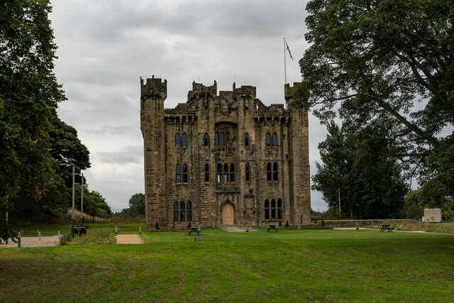
Hylton Castle

Hylton Castle ( HIL-tən) is a stone castle in the North Hylton area of Sunderland, Tyne and Wear, England. Originally built from wood by the Hilton (later...

Nearby Amenities

Located within 500m of 54.910843,-1.4507417
Created By: almien_coastlines
Source: PGS
Lat/Long: 54.9070294/-1.45389
Source: PGS
Lat/Long: 54.907374/-1.4535917
Created By: almien_coastlines
Source: PGS
Lat/Long: 54.9078237/-1.4531117
Created By: almien_coastlines
Source: PGS
Lat/Long: 54.9082007/-1.4525601
Created By: almien_coastlines
Source: PGS
Lat/Long: 54.9085434/-1.452054
Created By: almien_coastlines
Source: PGS
Lat/Long: 54.9089554/-1.4513772
Created By: almien_coastlines
Source: PGS
Lat/Long: 54.909174/-1.4506708
Created By: almien_coastlines
Source: PGS
Lat/Long: 54.909427/-1.4504398
Created By: almien_coastlines
Source: PGS
Lat/Long: 54.9096918/-1.4500581
Source: PGS
Lat/Long: 54.9098784/-1.4494159
Source: PGS
Lat/Long: 54.9102759/-1.4483859
Source: PGS
Lat/Long: 54.9104523/-1.4477797
Created By: almien_coastlines
Source: PGS
Lat/Long: 54.9106594/-1.447304
Created By: almien_coastlines
Source: PGS
Lat/Long: 54.9109044/-1.446405
Created By: almien_coastlines
Source: PGS
Lat/Long: 54.9111484/-1.445506
Created By: almien_coastlines
Source: PGS
Lat/Long: 54.9113994/-1.445052
Created By: almien_coastlines
Source: PGS
Lat/Long: 54.9116434/-1.444154
Created By: almien_coastlines
Source: PGS
Lat/Long: 54.9118944/-1.443699
Created By: almien_coastlines
Source: PGS
Lat/Long: 54.9106158/-1.4444301
Source: PGS
Lat/Long: 54.9102779/-1.4457522
Source: PGS
Lat/Long: 54.9099266/-1.4468034
Source: PGS
Lat/Long: 54.9097292/-1.4473561
Source: PGS
Lat/Long: 54.9095772/-1.4478006
Source: PGS
Lat/Long: 54.9095402/-1.4480569
Created By: almien_coastlines
Source: PGS
Lat/Long: 54.9095118/-1.4482531
Created By: almien_coastlines
Source: PGS
Lat/Long: 54.9093868/-1.4484791
Source: PGS
Lat/Long: 54.9091324/-1.4491509
Created By: almien_coastlines
Source: PGS
Lat/Long: 54.9086418/-1.4502861
Created By: almien_coastlines
Source: PGS
Lat/Long: 54.9085168/-1.4505141
Created By: almien_coastlines
Source: PGS
Lat/Long: 54.9083908/-1.4507401
Created By: almien_coastlines
Source: PGS
Lat/Long: 54.9080808/-1.4513449
Created By: almien_coastlines
Source: PGS
Lat/Long: 54.9077658/-1.4518761
Created By: almien_coastlines
Source: PGS
Lat/Long: 54.9074369/-1.4523581
Created By: almien_coastlines
Source: PGS
Lat/Long: 54.9071847/-1.452982
Source: PGS
Lat/Long: 54.9066635/-1.4534971
Bus Stop
FERRYBOAT LANE-BUSINESS PARK-S/B
Bench: no
Bus: yes
Local Ref: SE
Naptan AtcoCode: 410000023831
Naptan Bearing: SE
Naptan CommonName: FERRYBOAT LANE-BUSINESS PARK-S/B
Naptan Indicator: SE
Naptan Landmark: OUTSIDE THE SUNRISE ENTERPRISE PARK
Naptan NaptanCode: twrdtpga
Naptan PlusbusZoneRef: SNDRLND
Naptan Street: FERRYBOAT LANE
Naptan Verified: no
Public Transport: platform
Shelter: no
Source: naptan_import
Lat/Long: 54.9122286/-1.4561376
Bus Stop
Ferryboat Lane
Bench: no
Bus: yes
Departures Board: timetable
Local Ref: N
Naptan AtcoCode: 410000023832
Naptan Bearing: N
Naptan CommonName: FERRYBOAT LANE-BUSINESS PARK-N/B
Naptan Indicator: N
Naptan Landmark: OPPOSITE SUNRISE ENTERPRISE PAR
Naptan NaptanCode: twrdtpgd
Naptan PlusbusZoneRef: SNDRLND
Naptan Street: FERRYBOAT LANE
Naptan Verified: no
Public Transport: platform
Shelter: no
Source: naptan_import
Lat/Long: 54.9126183/-1.4569874
Bus Stop
NORTH HYLTON
Bus: yes
Local Ref: N
Naptan AtcoCode: 410000024192
Naptan Bearing: N
Naptan CommonName: NORTH HYLTON
Naptan Indicator: N
Naptan Landmark: OUTSIDE JUNCTION WITH LABURNUM GROVE
Naptan NaptanCode: twrdwdpa
Naptan PlusbusZoneRef: SNDRLND
Naptan Street: GRANGE ROAD
Naptan Verified: no
Public Transport: platform
Source: naptan_import
Lat/Long: 54.9133835/-1.4506131
Bus Stop
RINGWAY-TOLLERTON DRIVE-E/B
Bus: yes
Local Ref: E
Naptan AtcoCode: 410000024803
Naptan Bearing: E
Naptan CommonName: RINGWAY-TOLLERTON DRIVE-E/B
Naptan Indicator: E
Naptan Landmark: OUTSIDE THE RECREATION GROUND
Naptan NaptanCode: twrgadwm
Naptan PlusbusZoneRef: SNDRLND
Naptan Street: RINGWAY
Naptan Verified: no
Public Transport: platform
Source: naptan_import
Lat/Long: 54.9149282/-1.4504049
Bus Stop
GRANGE ROAD-ST MARGARETS AVENUE-W/B
Bus: yes
Local Ref: W
Naptan AtcoCode: 410000024807
Naptan Bearing: W
Naptan CommonName: GRANGE ROAD-ST MARGARETS AVENUE-W/B
Naptan Indicator: W
Naptan Landmark: OUTSIDE CRICKET GROUND
Naptan NaptanCode: twrgagag
Naptan PlusbusZoneRef: SNDRLND
Naptan Street: GRANGE ROAD
Naptan Verified: no
Public Transport: platform
Shelter: no
Source: naptan_import
Lat/Long: 54.9149435/-1.4478307
Bus Stop
GRANGE ROAD-RYDAL MOUNT-NE/B
Bus: yes
Local Ref: NE
Naptan AtcoCode: 410000024982
Naptan Bearing: NE
Naptan CommonName: GRANGE ROAD-RYDAL MOUNT-NE/B
Naptan Indicator: NE
Naptan Landmark: OUTSIDE SURGERY
Naptan NaptanCode: twrgajga
Naptan PlusbusZoneRef: SNDRLND
Naptan Street: GRANGE ROAD
Naptan Verified: no
Public Transport: platform
Source: naptan_import
Lat/Long: 54.9143122/-1.4493057
Bus Stop
Ferryboat Lane - Wessington Way (S/B)
Bus: yes
Local Ref: S
Naptan AtcoCode: 410000024983
Naptan Bearing: S
Naptan CommonName: FERRYBOAT LANE-WESSINGTON WAY-S/B
Naptan Indicator: S
Naptan Landmark: NORTH WEST OF TARRIL KENNELS
Naptan NaptanCode: twrgajgd
Naptan PlusbusZoneRef: SNDRLND
Naptan Street: FERRYBOAT LANE
Naptan Verified: no
Public Transport: platform
Source: naptan_import
Lat/Long: 54.9106823/-1.4534576
Bus Stop
RINGWAY-TOLLERTON DRIVE-W/B
Bus: yes
Local Ref: W
Naptan AtcoCode: 410000024991
Naptan Bearing: W
Naptan CommonName: RINGWAY-TOLLERTON DRIVE-W/B
Naptan Indicator: W
Naptan Landmark: OPPOSITE THE RECREATION GROUND
Naptan NaptanCode: twrgajmg
Naptan PlusbusZoneRef: SNDRLND
Naptan Street: RINGWAY
Naptan Verified: no
Public Transport: platform
Source: naptan_import
Lat/Long: 54.9148561/-1.4503591
Bus Stop
RINGWAY-WELWYN CLOSE-W/B
Bus: yes
Local Ref: W
Naptan AtcoCode: 410000024992
Naptan Bearing: W
Naptan CommonName: RINGWAY-WELWYN CLOSE-W/B
Naptan Indicator: W
Naptan Landmark: OUTSIDE THE SUNRISE ENTERPRISE PARK
Naptan NaptanCode: twrgajmj
Naptan PlusbusZoneRef: SNDRLND
Naptan Street: RINGWAY
Naptan Verified: no
Public Transport: platform
Source: naptan_import
Lat/Long: 54.9146489/-1.4542306
Bus Stop
SOUTH HYLTON CLAXHEUGH ROAD
Local Ref: E
Naptan AtcoCode: 410000060058
Naptan Bearing: E
Naptan CommonName: SOUTH HYLTON CLAXHEUGH ROAD
Naptan Indicator: E
Naptan Landmark: OPPOSITE KEELMAN'S ROAD JUNCTION
Naptan NaptanCode: twrgpmtp
Naptan PlusbusZoneRef: SNDRLND
Naptan Street: RIVERSIDE PARK
Naptan Verified: no
Source: naptan_import
Lat/Long: 54.909329/-1.4443512
Shop 'n' Drive
Addr Postcode: SR5 3NX
Fhrs Id: 651560
Shop: convenience
Source Addr: FHRS Open Data
Lat/Long: 54.9137771/-1.4450444
Honda Sunderland
Addr City: Sunderland
Addr Postcode: SR5 3NX
Addr Street: Wessington Way
Phone: +44 191 516 3349
Shop: car
Website: https://www.vertuhonda.com/
Lat/Long: 54.913531/-1.4458478
Post Box
Ref: SR4 53
Lat/Long: 54.909009/-1.4458388
Generator Method: photovoltaic
Generator Output Electricity: yes
Generator Source: solar
Generator Type: solar_photovoltaic_panel
Location: roof
Power: generator
Lat/Long: 54.9070251/-1.4516209
Generator Method: photovoltaic
Generator Output Electricity: yes
Generator Source: solar
Generator Type: solar_photovoltaic_panel
Location: roof
Power: generator
Lat/Long: 54.9070236/-1.4515834
Generator Method: photovoltaic
Generator Output Electricity: yes
Generator Solar Modules: 15
Generator Source: solar
Generator Type: solar_photovoltaic_panel
Location: roof
Power: generator
Lat/Long: 54.9074677/-1.4510617
Generator Method: photovoltaic
Generator Output Electricity: yes
Generator Source: solar
Generator Type: solar_photovoltaic_panel
Location: roof
Power: generator
Lat/Long: 54.9074901/-1.4509879
Generator Method: photovoltaic
Generator Output Electricity: yes
Generator Solar Modules: 9
Generator Source: solar
Generator Type: solar_photovoltaic_panel
Location: roof
Power: generator
Lat/Long: 54.9070251/-1.4467943
Generator Method: photovoltaic
Generator Output Electricity: yes
Generator Solar Modules: 9
Generator Source: solar
Generator Type: solar_photovoltaic_panel
Location: roof
Power: generator
Lat/Long: 54.9070498/-1.4467299
Generator Method: photovoltaic
Generator Output Electricity: yes
Generator Solar Modules: 9
Generator Source: solar
Generator Type: solar_photovoltaic_panel
Location: roof
Power: generator
Lat/Long: 54.9073258/-1.4461184
Generator Method: photovoltaic
Generator Output Electricity: yes
Generator Source: solar
Generator Type: solar_photovoltaic_panel
Location: roof
Power: generator
Lat/Long: 54.907278/-1.4459789
Generator Method: photovoltaic
Generator Output Electricity: yes
Generator Solar Modules: 12
Generator Source: solar
Generator Type: solar_photovoltaic_panel
Location: roof
Power: generator
Lat/Long: 54.90849/-1.445936
Generator Method: photovoltaic
Generator Output Electricity: yes
Generator Source: solar
Generator Type: solar_photovoltaic_panel
Location: roof
Power: generator
Lat/Long: 54.9093967/-1.4452976
Generator Method: photovoltaic
Generator Output Electricity: yes
Generator Solar Modules: 10
Generator Source: solar
Generator Type: solar_photovoltaic_panel
Location: roof
Power: generator
Lat/Long: 54.9096619/-1.4435944
Generator Method: photovoltaic
Generator Output Electricity: yes
Generator Solar Modules: 6
Generator Source: solar
Generator Type: solar_photovoltaic_panel
Location: roof
Power: generator
Lat/Long: 54.9097159/-1.4437124
Street Lamp
Lat/Long: 54.9111822/-1.4544734
Man Made: mast
Lat/Long: 54.9122877/-1.4561512
Give Way
Lat/Long: 54.910476/-1.4532316
Post Box
Brand: Royal Mail
Brand Wikidata: Q638098
Operator: Royal Mail
Operator Wikidata: Q638098
Post Box Type: pillar
Lat/Long: 54.9142553/-1.4492372
Bus Stop
Bus: yes
Public Transport: platform
Shelter: no
Lat/Long: 54.9148352/-1.4514083
North Hylton
Place: suburb
Lat/Long: 54.9072566/-1.4546569
The data included in this document is from www.openstreetmap.org. The data is made available under ODbL.

Have you been to Baron's Quay Wood?

Leave your review of Baron's Quay Wood below (or comments, questions and feedback).