Carr Wood

Wood, Forest in Yorkshire Harrogate

England

Carr Wood

Old milepost One of the two remaining mileposts along this 6 mile stretch of the B6265, this is how the photographer found it in March 2022.  When it was first recorded in 2006 it was already very sunken in this narrow verge.
Old milepost Credit: Hilary Jones

Carr Wood is a picturesque woodland located in Yorkshire, England. Situated in the heart of the countryside, this enchanting forest spans over a vast area, offering visitors a tranquil and captivating experience.

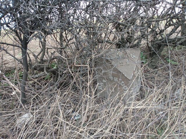
The wood is characterized by its dense canopy of towering trees, predominantly composed of oak, beech, and ash. The lush undergrowth is adorned with a vibrant array of wildflowers, creating a stunning tapestry of colors throughout the seasons. The forest floor is covered in a thick carpet of moss and ferns, adding to the woodland's magical atmosphere.

Carr Wood is a haven for wildlife, providing a sanctuary for a diverse range of species. Bird enthusiasts can spot various feathered friends, including woodpeckers, owls, and warblers, while those with a keen eye may catch a glimpse of elusive mammals such as deer and foxes. The wood is also teeming with smaller creatures like squirrels, rabbits, and a variety of insects.

For outdoor enthusiasts, Carr Wood offers an extensive network of walking trails, allowing visitors to immerse themselves in the natural beauty of the forest. These paths wind through the woodland, leading explorers to hidden glades, babbling brooks, and charming picnic spots. The wood also boasts a well-maintained visitor center, providing information about the local flora and fauna, as well as guided tours and educational programs for both adults and children.

Carr Wood is a true gem in the Yorkshire countryside, offering a serene escape from the hustle and bustle of everyday life. Whether you are seeking a peaceful stroll, a chance to reconnect with nature, or simply a break from the ordinary, this enchanting woodland is sure to captivate all who visit.

If you have any feedback on the listing, please let us know in the comments section below.

Carr Wood Images

Images are sourced within 2km of 54.11446/-1.463169 or Grid Reference SE3568. Thanks to Geograph Open Source API. All images are credited.

Old milepost One of the two remaining mileposts along this 6 mile stretch of the B6265, this is how the photographer found it in March 2022.  When it was first recorded in 2006 it was already very sunken in this narrow verge.
Old milepost
One of the two remaining mileposts along this 6 mile stretch of the B6265, this is how the photographer found it in March 2022. When it was first recorded in 2006 it was already very sunken in this narrow verge.
Old milepost After 25 minutes of clearing vegetation and soil by the photographer this milepost is now more visible.  As the verge at this point is only about a metre wide it may be difficult to completely refurbish it safely.  It is one of 14 known survivors of mileposts made by J Ingram, Ripon which are on the A61 from Ripon to Harrogate and the B6265 from Boroughbridge through Ripon to Pateley Bridge.
Old milepost
After 25 minutes of clearing vegetation and soil by the photographer this milepost is now more visible. As the verge at this point is only about a metre wide it may be difficult to completely refurbish it safely. It is one of 14 known survivors of mileposts made by J Ingram, Ripon which are on the A61 from Ripon to Harrogate and the B6265 from Boroughbridge through Ripon to Pateley Bridge.
Bogs Lane Access lane for Bogs House off the B6265 east of Ripon.
Bogs Lane
Access lane for Bogs House off the B6265 east of Ripon.
B6265 towards Boroughbridge Despite only being classified as a 'B' road, this route carries plenty of traffic, being the main route south east from Ripon towards the A1(M).
B6265 towards Boroughbridge
Despite only being classified as a 'B' road, this route carries plenty of traffic, being the main route south east from Ripon towards the A1(M).
Newby Hall
Newby Hall
Pond and statue, Newby Hall
Skelton, Pasture Lane, Low Moor House The benchmark is cut into the gable end of a stone agricultural building and is to the left of a drainpipe. The cutmark is damaged.
Skelton, Pasture Lane, Low Moor House
The benchmark is cut into the gable end of a stone agricultural building and is to the left of a drainpipe. The cutmark is damaged.
Skelton, Pasture Lane, Low Moor House There is a benchmark cut into the gable end of the stone agricultural building and is to the left of the furthest left green drainpipe. The cutmark is damaged.
Skelton, Pasture Lane, Low Moor House
There is a benchmark cut into the gable end of the stone agricultural building and is to the left of the furthest left green drainpipe. The cutmark is damaged.
Skelton on Ure, old agricultural barn The benchmark is cut into the left cornerstones of this old farm building situated on the edge of the village.
Skelton on Ure, old agricultural barn
The benchmark is cut into the left cornerstones of this old farm building situated on the edge of the village.
Skelton on Ure, old agricultural building There is a benchmark cut into the left cornerstones of this old farm building which is situated on the edge of the village and road junction.
Skelton on Ure, old agricultural building
There is a benchmark cut into the left cornerstones of this old farm building which is situated on the edge of the village and road junction.
Skelton on Ure, converted Methodist church The OS Flush Bracket S6737 is embedded in the south facing wall of the converted Methodist church.
Skelton on Ure, converted Methodist church
The OS Flush Bracket S6737 is embedded in the south facing wall of the converted Methodist church.
Skelton on Ure, converted Methodist church There is OS Flush Bracket S6737 embedded into the south facing wall of the converted Methodist church.
Skelton on Ure, converted Methodist church
There is OS Flush Bracket S6737 embedded into the south facing wall of the converted Methodist church.
Skelton on Ure, Black Lion PH The benchmark is cut across 2 courses of bricks on the left hand side of the road facing wall.
Skelton on Ure, Black Lion PH
The benchmark is cut across 2 courses of bricks on the left hand side of the road facing wall.
Skelton on Ure, closed Black Lion PH There is a benchmark cut across 2 courses of bricks on the left hand side of the road facing wall. Another closed and boarded up village pub.
Skelton on Ure, closed Black Lion PH
There is a benchmark cut across 2 courses of bricks on the left hand side of the road facing wall. Another closed and boarded up village pub.
Skelton on Ure, Christ the Consoler The benchmark is cut into the north-east facing wall, directly under a marvellous rose shaped stained glass window.
Skelton on Ure, Christ the Consoler
The benchmark is cut into the north-east facing wall, directly under a marvellous rose shaped stained glass window.
Skelton on Ure, Christ the Consoler There is a benchmark cut into the north-east facing wall, directly under the marvellous rose shaped stained glass window.
Skelton on Ure, Christ the Consoler
There is a benchmark cut into the north-east facing wall, directly under the marvellous rose shaped stained glass window.
Skelton on Ure, Christ the Consoler This is the 2nd benchmark cut into the church wall, and is on the south east facing wall.
Skelton on Ure, Christ the Consoler
This is the 2nd benchmark cut into the church wall, and is on the south east facing wall.
Skelton on Ure, Christ the Consoler There is a 2nd benchmark cut into the church wall, and this one is cut into the south east facing wall.
Skelton on Ure, Christ the Consoler
There is a 2nd benchmark cut into the church wall, and this one is cut into the south east facing wall.
Show me another place!

Carr Wood is located at Grid Ref: SE3568 (Lat: 54.11446, Lng: -1.463169)

Division: West Riding

Administrative County: North Yorkshire

District: Harrogate

Police Authority: North Yorkshire

What 3 Words

///fortified.topples.ticket. Near Boroughbridge, North Yorkshire

Nearby Locations

Carr Wood

Related Wikis

Skelton-on-Ure

Skelton-on-Ure or Skelton is a village and civil parish in the district and county of North Yorkshire, England. It is situated 1.9 miles (3 km) west of...

Church of Christ the Consoler

The Church of Christ the Consoler is a Victorian Gothic Revival church built in the Early English style by William Burges. It is located in the grounds...

Spectre of Newby Church

The Spectre of Newby Church (or the Newby Monk) is the name given to a figure found in a photograph taken in the Church of Christ the Consoler, on the...

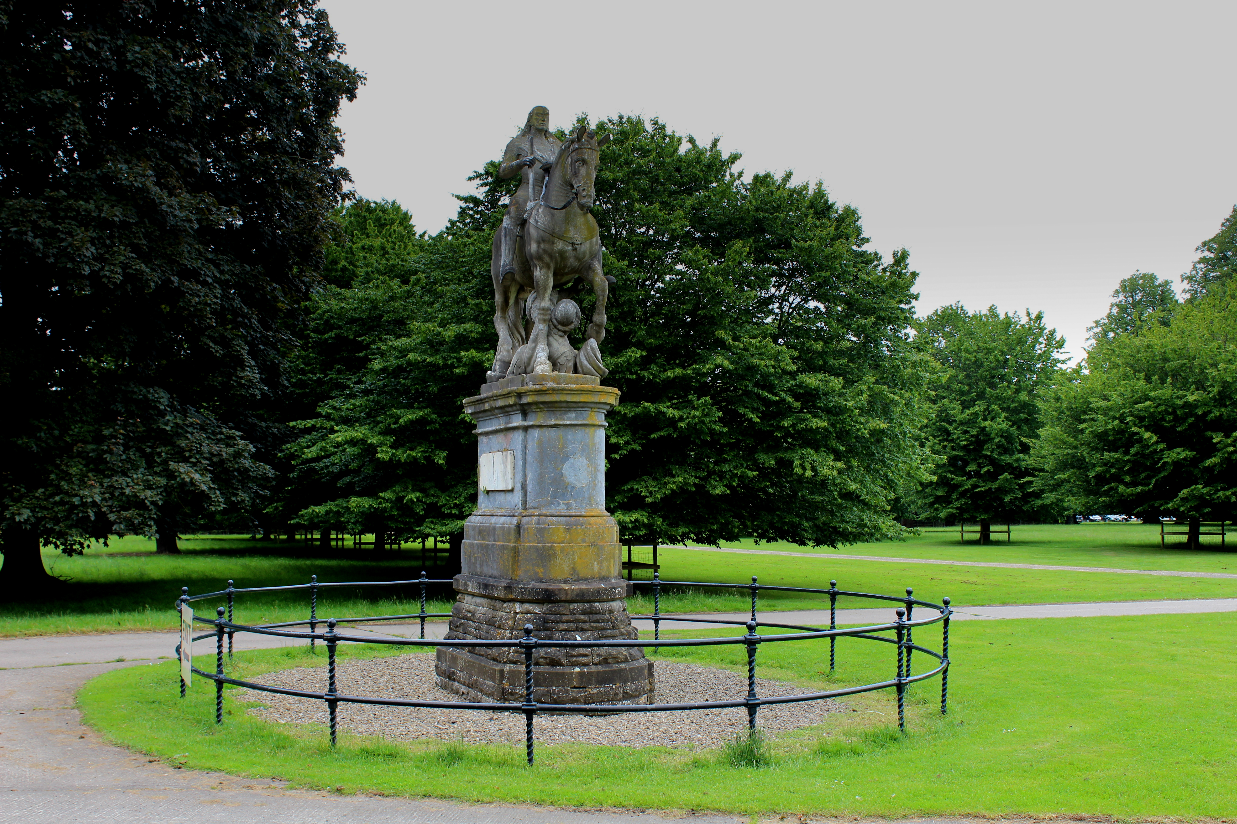
Equestrian statue of Charles II trampling Cromwell

An equestrian statue of Charles II trampling Cromwell stands near Newby Hall in North Yorkshire, England. It was previously sited at Gautby Hall in Lincolnshire...
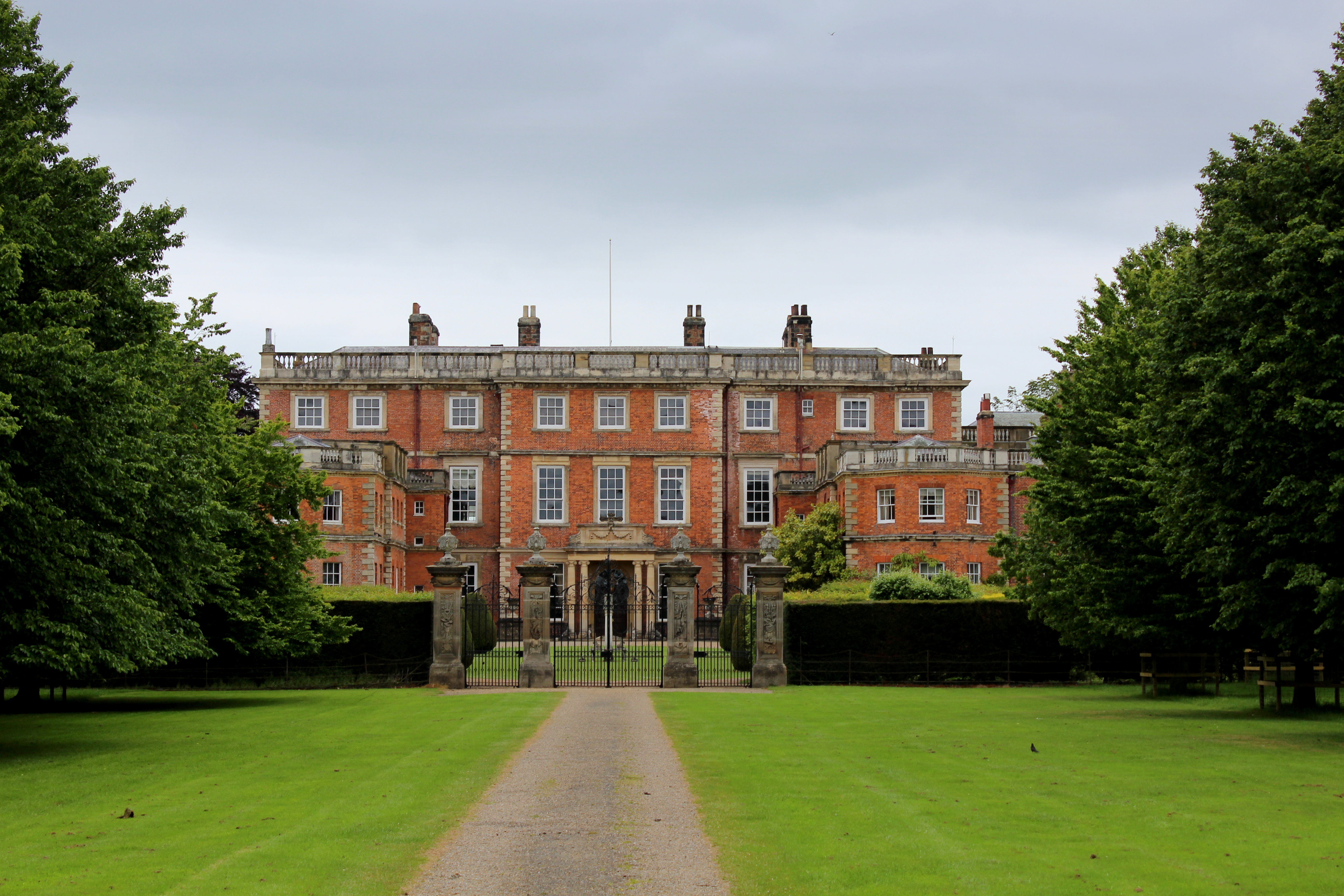
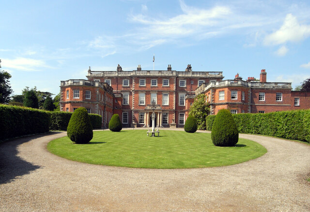
Newby Hall

Newby Hall is a country house beside the River Ure in the parish of Skelton-on-Ure in North Yorkshire, England. It is 3 miles (4.8 km) south-east of Ripon...

Bridge Hewick

Bridge Hewick is a village and civil parish in the Harrogate district of North Yorkshire, England. The village is situated on the River Ure, and approximately...
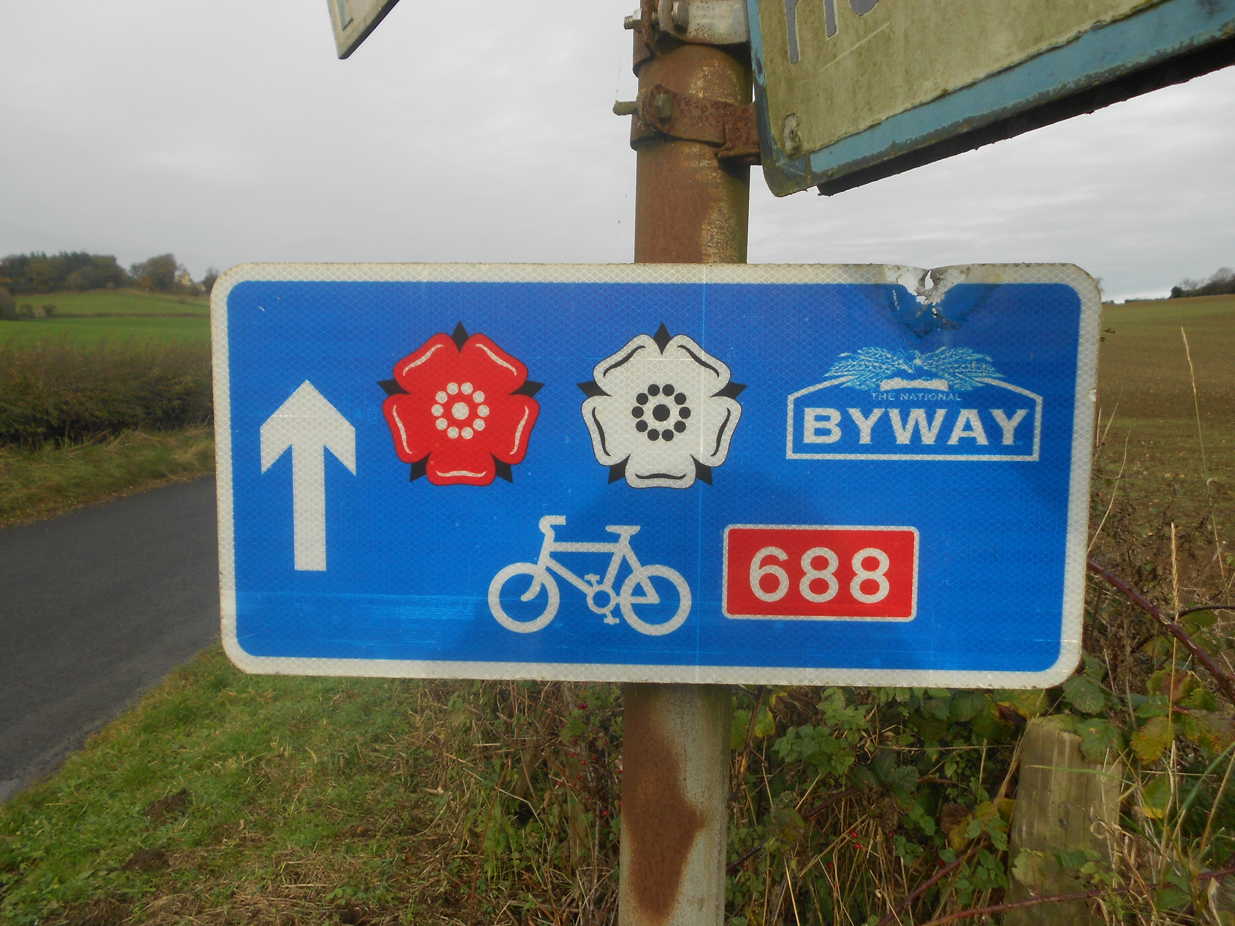
Way of the Roses

The Way of the Roses is the newest of Great Britain's coast-to-coast long-distance cycle routes and is based on minor roads, disused railway lines and...

Westwick, North Yorkshire

Westwick is a civil parish in Harrogate district in North Yorkshire, England. It lies 3 miles (5 km) west of Boroughbridge, on the south bank of the River...

Nearby Amenities

Located within 500m of 54.11446,-1.463169
Created By: Merkaartor 0.13
Lat/Long: 54.117578/-1.4595872
Created By: Merkaartor 0.13
Lat/Long: 54.1171912/-1.4585956
Created By: Merkaartor 0.13
Lat/Long: 54.1167837/-1.4580172
Created By: Merkaartor 0.13
Lat/Long: 54.1164038/-1.4574506
Created By: Merkaartor 0.13
Lat/Long: 54.1160101/-1.4565299
The data included in this document is from www.openstreetmap.org. The data is made available under ODbL.

Have you been to Carr Wood?

Leave your review of Carr Wood below (or comments, questions and feedback).