Archer's Alders

Wood, Forest in Derbyshire South Derbyshire

England

Archer's Alders

Power poles in Harry's Wood A lane has been left clear around the power lines, which also allows walking access. The wood is open-access but too densely planted for that to mean anything unless paths are maintained. Harry's Wood is part of the National Forest, planted with 70% oak and mixed with field maple and rowan, birch and alder.
Power poles in Harry's Wood Credit: Ian Calderwood

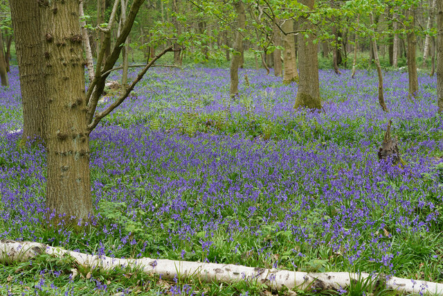
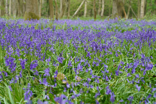
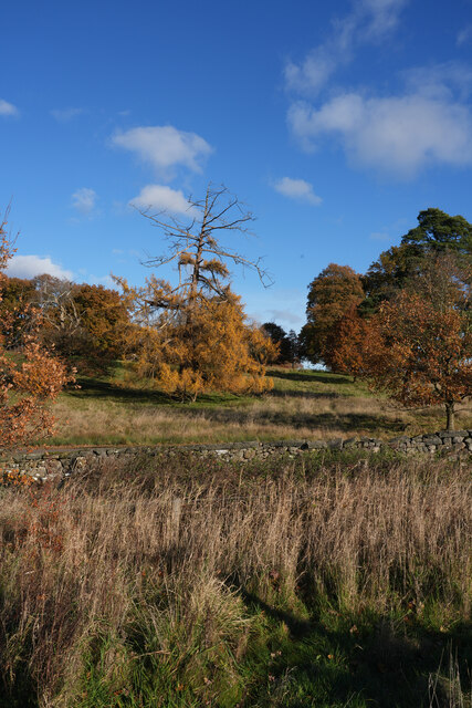
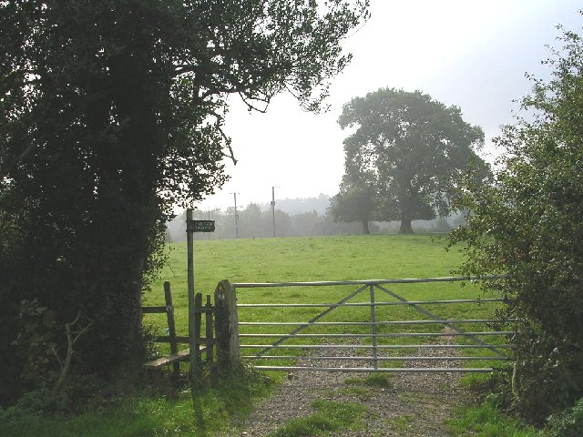
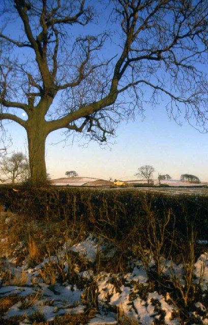
Archer's Alders is a picturesque woodland located in Derbyshire, England. Nestled within the heart of the Peak District National Park, it covers an area of approximately 100 hectares. Known for its stunning natural beauty and diverse range of flora and fauna, it is a popular destination for nature lovers and outdoor enthusiasts.

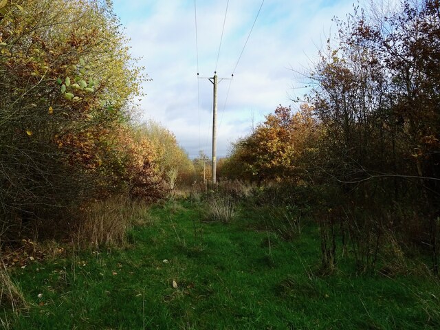
The woodland is primarily composed of alder trees, which give it its distinctive name. These trees thrive in the wet and boggy conditions found in the area, adding to the unique character of the forest. The dense canopy of leaves provides shade, creating a cool and tranquil atmosphere throughout the woodland.

Archer's Alders is home to a rich variety of wildlife, making it a haven for wildlife enthusiasts. Visitors can spot numerous bird species, including woodpeckers, jays, and owls. The forest floor is teeming with small mammals such as rabbits, squirrels, and voles, while the rivers that flow through the woodland attract otters and various fish species.

The woodland offers various walking trails, allowing visitors to explore its beauty at their own pace. These trails meander through the forest, crossing over babbling brooks and passing by idyllic ponds. Along the way, visitors can enjoy the sights and sounds of nature, from the rustling of leaves to the chirping of birds.

Archer's Alders is a true gem of Derbyshire, offering a peaceful retreat from the hustle and bustle of everyday life. With its breathtaking scenery and abundant wildlife, it is a must-visit destination for nature enthusiasts and those seeking a tranquil escape in the heart of the Peak District.

If you have any feedback on the listing, please let us know in the comments section below.

Archer's Alders Images

Images are sourced within 2km of 52.791221/-1.4851095 or Grid Reference SK3421. Thanks to Geograph Open Source API. All images are credited.

Power poles in Harry's Wood A lane has been left clear around the power lines, which also allows walking access. The wood is open-access but too densely planted for that to mean anything unless paths are maintained. Harry's Wood is part of the National Forest, planted with 70% oak and mixed with field maple and rowan, birch and alder.
Power poles in Harry's Wood
A lane has been left clear around the power lines, which also allows walking access. The wood is open-access but too densely planted for that to mean anything unless paths are maintained. Harry's Wood is part of the National Forest, planted with 70% oak and mixed with field maple and rowan, birch and alder.
Public footpath to Smisby An old field path, marked on 19th century maps, which has been incorporated into the National Forest Way.
Public footpath to Smisby
An old field path, marked on 19th century maps, which has been incorporated into the National Forest Way.
Footpath across a field of stubble The official line of the path runs to the right of the straight line used now, on the line of an old lane or track that ran along a field boundary. The original line has been obliterated by ploughing, since the fields were merged in the late 20th century.
Footpath across a field of stubble
The official line of the path runs to the right of the straight line used now, on the line of an old lane or track that ran along a field boundary. The original line has been obliterated by ploughing, since the fields were merged in the late 20th century.
Footpath on the edge of Harry's Wood A preexisting footpath has been incorporated into the perimeter path and permissive bridleway around Harry's Wood. Harry's Wood is part of the National Forest, planted with 70% oak and mixed with field maple and rowan, birch and alder.
Footpath on the edge of Harry's Wood
A preexisting footpath has been incorporated into the perimeter path and permissive bridleway around Harry's Wood. Harry's Wood is part of the National Forest, planted with 70% oak and mixed with field maple and rowan, birch and alder.
Stile on the edge of Harry's Wood This stile gives access to a public footpath and the perimeter path around Harry's Wood. Harry's Wood is part of the National Forest, planted with 70% oak and mixed with field maple and rowan, birch and alder.
Stile on the edge of Harry's Wood
This stile gives access to a public footpath and the perimeter path around Harry's Wood. Harry's Wood is part of the National Forest, planted with 70% oak and mixed with field maple and rowan, birch and alder.
Bluebells at Calke Park The Bluebells this year are very good. There are lots is several areas of Calke Park.
Bluebells at Calke Park
The Bluebells this year are very good. There are lots is several areas of Calke Park.
Bluebells at Calke Park A closeup of the flowers shown in <a href="https://www.geograph.org.uk/photo/7162441">SK3522 : Bluebells at Calke Park</a> at Calke Park. This is a National Trust property. When we arrived quite early there were about 12 cars in the main car park. After our walk the car park was full and the overflow car park was filling up.
Bluebells at Calke Park
A closeup of the flowers shown in SK3522 : Bluebells at Calke Park at Calke Park. This is a National Trust property. When we arrived quite early there were about 12 cars in the main car park. After our walk the car park was full and the overflow car park was filling up.
The view from the entrance Looking out from Calke Abbey towards the gardens which are up the hill and to the left.
The view from the entrance
Looking out from Calke Abbey towards the gardens which are up the hill and to the left.
A golden Larch The  tree with the bare top is a Larch, an unusual conifer which sheds its leaves in the autumn like deciduous trees.
A golden Larch
The tree with the bare top is a Larch, an unusual conifer which sheds its leaves in the autumn like deciduous trees.
More Autumnal colour Now making our way back to the cafe for a drink, the sun shining on the trees is bringing out the vibrant colour.
More Autumnal colour
Now making our way back to the cafe for a drink, the sun shining on the trees is bringing out the vibrant colour.
Calke Park This is the first time for many days it has not been heavily overcast for more than a week.
Calke Park
This is the first time for many days it has not been heavily overcast for more than a week.
Calke Park This extensive landscape park surrounds Calke Abbey and is in the hands of the National Trust.
Calke Park
This extensive landscape park surrounds Calke Abbey and is in the hands of the National Trust.
Poker's Leys Wood
Poker's Leys Wood
Footpath to Smisby The area around Calke Abbey is very rural, there are many footpaths leading through fields which take you back a thousand years.
Footpath to Smisby
The area around Calke Abbey is very rural, there are many footpaths leading through fields which take you back a thousand years.
Thawing Out Thawing out, Coppice House Farm
Thawing Out
Thawing out, Coppice House Farm
Tadsor Farm on Pistern Hill The picture is taken from the junction of Coal lane / B5006. It shows Tadsor farm on the western end of Pistern Hill. Pistern hill is mainly composed of Keuper sandstone & marls from the Triassic period topped with boulder clay. The NE facing scarp of the hill (shown in the view) is mainly wooded and produces wonderful displays of bluebells in spring (visible from the road). Wild deer and buzzards can also be observed.
Tadsor Farm on Pistern Hill
The picture is taken from the junction of Coal lane / B5006. It shows Tadsor farm on the western end of Pistern Hill. Pistern hill is mainly composed of Keuper sandstone & marls from the Triassic period topped with boulder clay. The NE facing scarp of the hill (shown in the view) is mainly wooded and produces wonderful displays of bluebells in spring (visible from the road). Wild deer and buzzards can also be observed.
Veteran Trees Some surveys suggest that Britain may be home to around 80% of the veteran trees in Western Europe.  A veteran tree is a general term for an old tree that is noteworthy for its historic, ecological, economic value etc.  This picture was taken during a training day to help volunteer surveyors identify and record veteran trees in order to preserve and protect them.
Veteran Trees
Some surveys suggest that Britain may be home to around 80% of the veteran trees in Western Europe. A veteran tree is a general term for an old tree that is noteworthy for its historic, ecological, economic value etc. This picture was taken during a training day to help volunteer surveyors identify and record veteran trees in order to preserve and protect them.
The Old Man of Calke This ancient oak tree in Calke Park is believed to be anything up to 1500 years old and is a prime example of a veteran tree.  It is suggested that there may be no more than a hundred or so trees of this age and historic significance in the whole of Western Europe.
The Old Man of Calke
This ancient oak tree in Calke Park is believed to be anything up to 1500 years old and is a prime example of a veteran tree. It is suggested that there may be no more than a hundred or so trees of this age and historic significance in the whole of Western Europe.
Show me another place!

Archer's Alders is located at Grid Ref: SK3421 (Lat: 52.791221, Lng: -1.4851095)

Administrative County: Derbyshire

District: South Derbyshire

Police Authority: Derbyshire

What 3 Words

///reach.duplicity.harvest. Near Ashby de la Zouch, Leicestershire

Related Wikis

Calke Abbey

Calke Abbey is a Grade I listed country house near Ticknall, Derbyshire, England, in the care of the charitable National Trust. The site was an Augustinian...

Ticknall Tramway

The Ticknall Tramway was a 12.8 mi (20.6 km) long 4 ft 2 in (1,270 mm) gauge horse-drawn plateway terminating at Ticknall, Derbyshire, England. It operated...

Ticknall

Ticknall is a small village and civil parish in South Derbyshire, England. The population of the civil parish (including Calke) at the 2011 Census was...

Smisby

Smisby is an ancient manor, civil parish and small village in South Derbyshire, England. It is 4 miles (6.4 km) from Melbourne and near the Leicestershire...

Boundary, Derbyshire

Boundary is a large hamlet and as The Boundary a former civil parish, in South Derbyshire situated between the towns of Swadlincote and Ashby-de-la-Zouch...

St James' Church, Smisby

St James’ Church, Smisby is a Grade I listed parish church in the Church of England in Smisby, Derbyshire. == History == The church is medieval with elements...

St George's Church, Ticknall

St George's Church, Ticknall is a Grade II listed parish church in the Church of England in Ticknall, Derbyshire. == History == The church was built in...

Calke

Calke is a small village and civil parish in the South Derbyshire district of Derbyshire, England. It includes the historic house Calke Abbey, a National...

Nearby Amenities

Located within 500m of 52.791221,-1.4851095
White Hollows Cottages
Place: locality
Source: OS OpenData StreetView
Lat/Long: 52.7941342/-1.4813836
Bus Stop
Coal Lane East End
Naptan AtcoCode: 100000008718
Naptan NaptanCode: dbsgmdwm
Public Transport: platform
Lat/Long: 52.7937941/-1.490232
Bus Stop
Coal Lane East End
Public Transport: platform
Lat/Long: 52.7937268/-1.4902695
Power: pole
Lat/Long: 52.7939575/-1.480267
Power: pole
Lat/Long: 52.7935102/-1.4812084
Power: pole
Lat/Long: 52.7930736/-1.482394
Power: pole
Lat/Long: 52.7926734/-1.4835018
Power: pole
Lat/Long: 52.7922411/-1.4846591
Power: pole
Lat/Long: 52.7919179/-1.4856006
The data included in this document is from www.openstreetmap.org. The data is made available under ODbL.

Have you been to Archer's Alders?

Leave your review of Archer's Alders below (or comments, questions and feedback).