Halton Moor Wood

Wood, Forest in Yorkshire

England

Halton Moor Wood

Leeds Skelton Lake Services Skelton Lake services is located on Junction 45 of the M1 motorway and operated by Extra. Construction of the service area began in the summer of 2018. but when it opened, on 30 March 2020, only the general shop and fuelling station were able to operate. The main facilities remained closed due to the ongoing coronavirus pandemic with the first few facilities in the main building opening on 1 July 2020.
Leeds Skelton Lake Services Credit: Gerald England

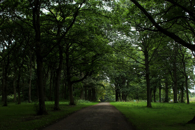
Halton Moor Wood is a picturesque woodland located in the county of Yorkshire, England. Covering an area of approximately 100 acres, it is a haven of natural beauty and tranquility. The wood is situated in close proximity to the village of Halton Moor and is easily accessible to visitors.

The woodland is predominantly composed of broadleaf trees, such as oak, beech, and birch, which create a rich and diverse ecosystem. The dense canopy provides a sheltered habitat for a variety of wildlife, including birds, mammals, and insects. Visitors to Halton Moor Wood may be lucky enough to spot species such as woodpeckers, red squirrels, and butterflies amidst the lush vegetation.

The wood is crisscrossed by a network of well-maintained walking trails, allowing visitors to explore its beauty at their own pace. These paths offer breathtaking views of the surrounding countryside, making it a popular destination for nature enthusiasts and hikers. In addition to the walking trails, there are designated picnic areas where visitors can relax and enjoy the peaceful atmosphere.

Halton Moor Wood is also known for its historical significance. It is believed that the wood has been in existence since medieval times, and remnants of ancient settlements and boundary markers can still be found within its boundaries. This adds an element of intrigue and mystique to the woodland, attracting those interested in history and archaeology.

Overall, Halton Moor Wood is a delightful destination for those seeking a peaceful retreat in the heart of Yorkshire. Its natural beauty, diverse wildlife, and historical significance make it a must-visit location for nature lovers and history enthusiasts alike.

If you have any feedback on the listing, please let us know in the comments section below.

Halton Moor Wood Images

Images are sourced within 2km of 53.789334/-1.4773598 or Grid Reference SE3432. Thanks to Geograph Open Source API. All images are credited.

Leeds Skelton Lake Services Skelton Lake services is located on Junction 45 of the M1 motorway and operated by Extra. Construction of the service area began in the summer of 2018. but when it opened, on 30 March 2020, only the general shop and fuelling station were able to operate. The main facilities remained closed due to the ongoing coronavirus pandemic with the first few facilities in the main building opening on 1 July 2020.
Leeds Skelton Lake Services
Skelton Lake services is located on Junction 45 of the M1 motorway and operated by Extra. Construction of the service area began in the summer of 2018. but when it opened, on 30 March 2020, only the general shop and fuelling station were able to operate. The main facilities remained closed due to the ongoing coronavirus pandemic with the first few facilities in the main building opening on 1 July 2020.
M1 Junction 45 
Junction 45 of the M1 motorway was constructed in 1999 but remained closed for almost a decade whilst Leeds City Council went through the legal processes to divert the A63. The East Leeds Link Road  mostly follows Pontefract Lane and is an upgrade to a pre-existing lane through brownfield areas. In 2018 construction of Skelton Lake services began but when it opened, on 30 March 2020, only the general shop and fuelling station were able to operate. The main facilities remained closed due to the ongoing coronavirus pandemic with the first few facilities in the main building opening on 1 July 2020.
M1 Junction 45
Junction 45 of the M1 motorway was constructed in 1999 but remained closed for almost a decade whilst Leeds City Council went through the legal processes to divert the A63. The East Leeds Link Road mostly follows Pontefract Lane and is an upgrade to a pre-existing lane through brownfield areas. In 2018 construction of Skelton Lake services began but when it opened, on 30 March 2020, only the general shop and fuelling station were able to operate. The main facilities remained closed due to the ongoing coronavirus pandemic with the first few facilities in the main building opening on 1 July 2020.
Skelton Lake Circuit 1, starting at Skelton Lake Services This is a new motorway services on the M1 at J45. Their advertisement mentions that you can use it as a base for walks. There is a bridleway all the way round Skelton Lake. This view is from the back door. To go round clockwise head for the white rectangular board towards the left of the image. To go round clockwise turn right and head for a stile onto the bridleway.
Skelton Lake Circuit 1, starting at Skelton Lake Services
This is a new motorway services on the M1 at J45. Their advertisement mentions that you can use it as a base for walks. There is a bridleway all the way round Skelton Lake. This view is from the back door. To go round clockwise head for the white rectangular board towards the left of the image. To go round clockwise turn right and head for a stile onto the bridleway.
Skelton Lake Circuit 11 Approaching Skelton Lake Services near the end of the circuit. The main building has a grass-covered roof. the concrete block in front of it is the Ramada Hotel - a pity it was built in a different style.
Skelton Lake Circuit 11
Approaching Skelton Lake Services near the end of the circuit. The main building has a grass-covered roof. the concrete block in front of it is the Ramada Hotel - a pity it was built in a different style.
Recycling and Energy Recovery Facility on Pontefract Lane This facility is designed to remove recyclable waste from black bins and recover energy from what is left over.
it will significantly reduce the amount sent to landfill.
Opened in 2016.
<a href="https://www.geograph.org.uk/photo/5655686">SE3232 : Leeds incinerator - west end</a>
Recycling and Energy Recovery Facility on Pontefract Lane
This facility is designed to remove recyclable waste from black bins and recover energy from what is left over. it will significantly reduce the amount sent to landfill. Opened in 2016. SE3232 : Leeds incinerator - west end
Temple Newsam, North Wing Tudor-Jacobean House in the centre of huge grounds designed by Capability Brown, located to the south east of Leeds.
Grade I Listed, and in the ownership of Leeds City Council.
The grounds and gardens are free, but there is a fee to visit the house and museum.
Temple Newsam, North Wing
Tudor-Jacobean House in the centre of huge grounds designed by Capability Brown, located to the south east of Leeds. Grade I Listed, and in the ownership of Leeds City Council. The grounds and gardens are free, but there is a fee to visit the house and museum.
Sycamore Walk, Temple Newsam In the grounds of Temple Newsam Country Park
Sycamore Walk, Temple Newsam
In the grounds of Temple Newsam Country Park
The Stable Block, Temple Newsam The stable block, now used for the gift shop, ticket office and cafe with seating area.
The Stable Block, Temple Newsam
The stable block, now used for the gift shop, ticket office and cafe with seating area.
Walled Garden, Temple Newsam (1) Row of empty benches in the walled garden at Temple Newsam
Walled Garden, Temple Newsam (1)
Row of empty benches in the walled garden at Temple Newsam
Walled Garden, Temple Newsam (2) Stripped of all vegetation except the lawn, and awaiting fresh planting
Walled Garden, Temple Newsam (2)
Stripped of all vegetation except the lawn, and awaiting fresh planting
Walled Garden, Temple Newsam (3) Walled or Rose Garden at Temple Newsam
Walled Garden, Temple Newsam (3)
Walled or Rose Garden at Temple Newsam
Leeds Skelton Lake Services The view on the M1 services near junction 45.
Leeds Skelton Lake Services
The view on the M1 services near junction 45.
Skelton Lake Services The view on the M1 services near junction 45, Leeds.
Skelton Lake Services
The view on the M1 services near junction 45, Leeds.
Seacroft hospital tower The tower was built in 1904 as a water tower as part of the expansion of the original infectious diseases isolation hospital, architect E T Hall. Source: Historic England grade II listing (list entry 1255580). Possibly the only water tower with a public clock?
Seacroft hospital tower
The tower was built in 1904 as a water tower as part of the expansion of the original infectious diseases isolation hospital, architect E T Hall. Source: Historic England grade II listing (list entry 1255580). Possibly the only water tower with a public clock?
Outpatients building, Seacroft hospital One of the more modern buildings at the hospital.
Outpatients building, Seacroft hospital
One of the more modern buildings at the hospital.
Killingbeck Pond Small body of water beside York Road (A64), and easily missed by the passing traffic.
Part of the Killingbeck Fields Local Nature Reserve, and passed by the Wyke Beck green corridor.
Killingbeck Pond
Small body of water beside York Road (A64), and easily missed by the passing traffic. Part of the Killingbeck Fields Local Nature Reserve, and passed by the Wyke Beck green corridor.
Show me another place!

Halton Moor Wood is located at Grid Ref: SE3432 (Lat: 53.789334, Lng: -1.4773598)

Division: West Riding

Unitary Authority: Leeds

Police Authority: West Yorkshire

What 3 Words

///valley.wisdom.deed. Near Swillington, West Yorkshire

Related Wikis

Halton Moor

Halton Moor is a district of east Leeds, West Yorkshire, England, about three miles east of Leeds city centre close to the A63. It is situated between...

Halton, Leeds

Halton is a district of east Leeds, West Yorkshire, England, situated between Cross Gates to the north, Halton Moor to the west, Colton to the east and...

Corpus Christi Catholic College

Corpus Christi Catholic College is a co-educational secondary school located in Halton Moor, Leeds, West Yorkshire, England. The school currently has a...

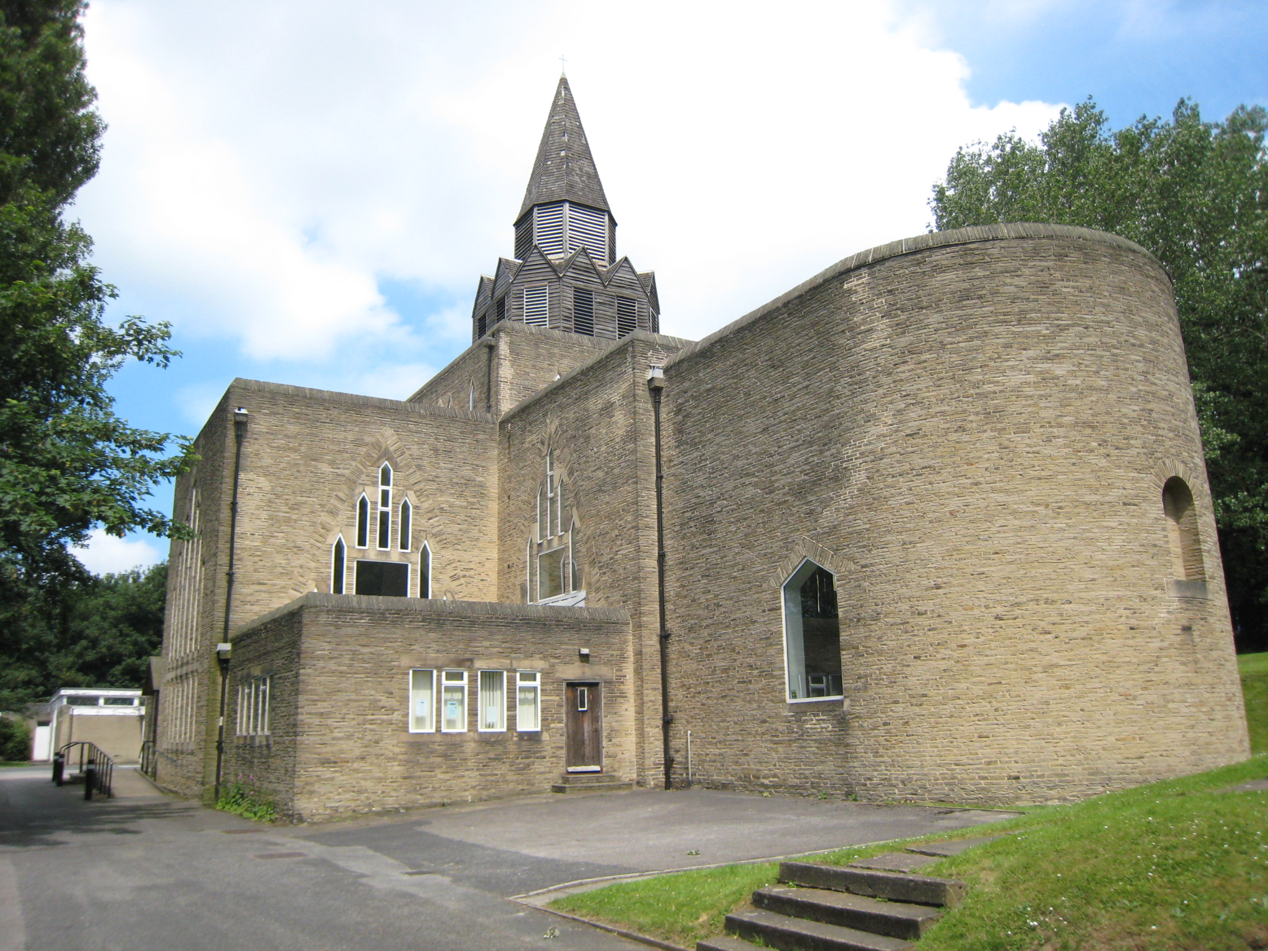
St Wilfrid's Church, Halton, Leeds

St Wilfrid's Church, Halton was designed by Albert Randall Wells and built between 1937 and 1939. It is situated in the 1930s suburb of Halton in Leeds...
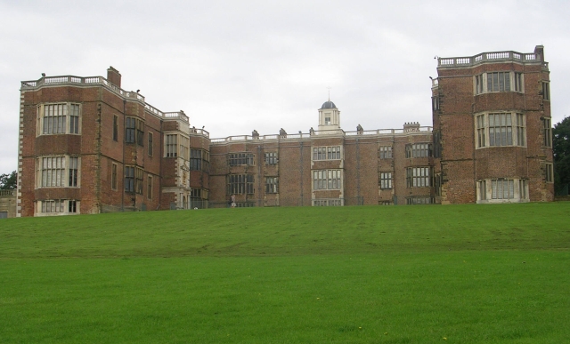
Temple Newsam

Temple Newsam (historically Temple Newsham, grid reference SE357322) is a Tudor-Jacobean house in Leeds, West Yorkshire, England, with grounds landscaped...

Temple Moor High School

Temple Moor High School is a coeducational secondary school and sixth form located in Leeds, West Yorkshire, England. In recent years, it has received...

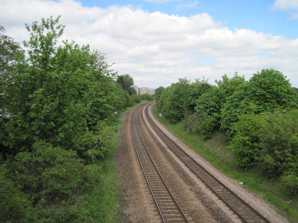
Osmondthorpe railway station

Osmondthorpe was a railway station between Leeds and Cross Gates on the Leeds to York Line (part of the Cross Country Route). It was opened as Osmondthorpe...

Wykebeck

Wykebeck is an area of east Leeds, West Yorkshire, England named after the Wyke Beck and situated between Gipton and Seacroft along Wykebeck Road. The...

Nearby Amenities

Located within 500m of 53.789334,-1.4773598
Traffic Calming: choker
Lat/Long: 53.7900758/-1.4839799
Mini Roundabout
Direction: clockwise
Lat/Long: 53.7889541/-1.4827704
Turning Circle
Lat/Long: 53.7924782/-1.4810053
Mini Roundabout
Direction: clockwise
Lat/Long: 53.7926493/-1.4795765
Traffic Calming: choker
Lat/Long: 53.7916728/-1.4771193
Bus Stop
Ullswater Crescent Coronation Parade
Bus: yes
Local Ref: 45024987
Naptan AtcoCode: 450024987
Naptan Bearing: NE
Naptan CommonName: Ullswater Crescent Coronation Parade
Naptan Crossing: Coronation Parade
Naptan Indicator: Stop 45024987
Naptan PlusbusZoneRef: LEEDS
Naptan ShortCommonName: Coronation Parade
Naptan Street: Ullswater Crescent
Naptan Verified: no
Public Transport: platform
Source: naptan_import
Lat/Long: 53.7926386/-1.4824112
Bus Stop
Ullswater Crescent Coronation Parade
Bus: yes
Naptan AtcoCode: 450028983
Naptan Bearing: S
Naptan CommonName: Ullswater Crescent Coronation Parade
Naptan Crossing: Coronation Parade
Naptan Landmark: Unknown
Naptan Notes: created at request of Richard Lake for First route-building purposes
Naptan ShortCommonName: Ullswater Crescent
Naptan Street: Ullswater Crescent
Naptan Verified: no
Public Transport: platform
Source: naptan_import
Lat/Long: 53.7925209/-1.4822305
Rathmell Road Westminster Crescent
Local Ref: 45050043
Naptan AtcoCode: 450050043
Naptan Bearing: N
Naptan BusStopType: CUS
Naptan CommonName: Rathmell Road Westminster Crescent
Naptan Indicator: Stop 45050043
Naptan PlusbusZoneRef: LEEDS
Naptan ShortCommonName: Rathmell Road
Naptan Street: Rathmell Road
Naptan Verified: no
Source: naptan_import
Lat/Long: 53.7918349/-1.4772353
Post Box
Operator: Royal Mail
Operator Wikidata: Q638098
Post Box Type: pillar
Ref: LS15 940
Royal Cypher: EIIR
Royal Cypher Wikidata: Q33102113
Lat/Long: 53.7901994/-1.4843413
Post Box
Brand: Royal Mail
Brand Wikidata: Q638098
Brand Wikipedia: en:Royal Mail
Operator: Royal Mail
Operator Wikidata: Q638098
Post Box Type: wall
Ref: LS15 805
Royal Cypher: GVIR
Royal Cypher Wikidata: Q33102169
Lat/Long: 53.793348/-1.475814
Man Made: survey_point
Source: OS 1:25k
Lat/Long: 53.7876969/-1.4820407
Barrier: cycle_barrier
Lat/Long: 53.7888725/-1.4828357
Give Way
Direction: forward
Lat/Long: 53.7890461/-1.4828212
Turning Circle
Lat/Long: 53.7909451/-1.4799568
Turning Circle
Lat/Long: 53.7898748/-1.4804715
Ullswater Newsagents
Addr City: Leeds
Addr Housenumber: 81-83
Addr Postcode: LS15 0BW
Addr Street: Ullswater Crescent
Addr Suburb: Halton
Fhrs Id: 320272
Shop: newsagent
Lat/Long: 53.7929308/-1.4814645
Turning Circle
Lat/Long: 53.7925544/-1.4813476
Turning Circle
Lat/Long: 53.7911237/-1.4814413
Turning Circle
Lat/Long: 53.7928042/-1.474693
Traffic Calming: cushion
Lat/Long: 53.7937644/-1.4776931
Traffic Calming: choker
Lat/Long: 53.7922563/-1.4772369
Turning Circle
Turning Circle: circle
Lat/Long: 53.7885519/-1.4826311
Crossing
Lat/Long: 53.7881482/-1.4826758
Crossing
Crossing: unmarked
Lat/Long: 53.7865642/-1.4812418
Crossing
Lat/Long: 53.7871325/-1.4821335
Barrier: motorcycle_barrier
Lat/Long: 53.7914096/-1.4745481
Barrier: cycle_barrier
Lat/Long: 53.791391/-1.4748113
Barrier: motorcycle_barrier
Lat/Long: 53.7917871/-1.4729777
Bus Stop
Skelton Moor Way
Bus: yes
Public Transport: platform
Ref: 45032124
Lat/Long: 53.7884352/-1.4826749
Waste Basket
Ref UK Leedscc Bin: 791
Lat/Long: 53.792475/-1.481089
Waste Basket
Ref UK Leedscc Bin: 3387
Lat/Long: 53.792626/-1.482198
Crossing
Lat/Long: 53.7865738/-1.4831222
Crossing
Lat/Long: 53.7854558/-1.4809226
Crossing
Lat/Long: 53.7862622/-1.4810598
Crossing
Lat/Long: 53.7870117/-1.4812093
Crossing
Lat/Long: 53.787808/-1.4822493
Recycling
Operator: Leeds City Council
Recycling Glass Bottles: yes
Recycling Type: container
Lat/Long: 53.7891689/-1.4826515
Barrier: bollard
Lat/Long: 53.7892776/-1.4824221
Give Way
Direction: backward
Lat/Long: 53.7889512/-1.4826186
Barrier: horse_stile
Lat/Long: 53.7888721/-1.4828033
The data included in this document is from www.openstreetmap.org. The data is made available under ODbL.

Have you been to Halton Moor Wood?

Leave your review of Halton Moor Wood below (or comments, questions and feedback).