Bath Plantation

Wood, Forest in Durham

England

Bath Plantation

Temple of Minerva One of the many follies in Hardwick Hall Country Park
Temple of Minerva Credit: Kevin Waterhouse

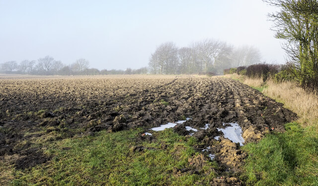
Bath Plantation is a picturesque woodland located in Durham, England. Spanning over a vast area, it is known for its abundant natural beauty and diverse range of flora and fauna. The plantation primarily consists of deciduous trees, with oak and beech being the dominant species, providing a stunning display of colors in autumn.

The woodland offers a tranquil escape from the bustling city life, with its well-maintained trails and pathways inviting visitors to explore its serene surroundings. The dense canopy of trees provides shade and shelter, making it a popular spot for picnics and recreational activities such as hiking and birdwatching.

Bath Plantation is also home to a wide array of wildlife. Bird enthusiasts can spot various species, including woodpeckers, jays, and tawny owls, among others. Squirrels, badgers, and rabbits are also commonly seen, adding to the charm of this natural haven.

The management of Bath Plantation focuses on preserving and enhancing its ecological value. Regular conservation efforts are undertaken to protect the native flora and fauna, ensuring the long-term sustainability of this woodland ecosystem.

Located just a short distance from Durham City, Bath Plantation offers a convenient escape for both locals and tourists seeking a peaceful retreat amidst nature. Its accessibility and natural beauty make it a popular destination for nature lovers and outdoor enthusiasts alike, providing an opportunity to connect with the tranquility and serenity of the countryside.

If you have any feedback on the listing, please let us know in the comments section below.

Bath Plantation Images

Images are sourced within 2km of 54.64802/-1.4729636 or Grid Reference NZ3428. Thanks to Geograph Open Source API. All images are credited.

Temple of Minerva One of the many follies in Hardwick Hall Country Park
Temple of Minerva
One of the many follies in Hardwick Hall Country Park
The Gothic Seat One of the many follies in Hardwick Hall Country Park
The Gothic Seat
One of the many follies in Hardwick Hall Country Park
Sedgefield, 62 Front Street 62 Front Street is a Premier Convenience Store. The benchmark is cut into the left, north-east face of the shop.
Sedgefield, 62 Front Street
62 Front Street is a Premier Convenience Store. The benchmark is cut into the left, north-east face of the shop.
Sedgefield, 62 Front Street 62 Front Street is a Premier Convenience Store. There is a benchmark cut into the left, north-east face of the shop. The benchmark and facia of the shop is painted cream.
Sedgefield, 62 Front Street
62 Front Street is a Premier Convenience Store. There is a benchmark cut into the left, north-east face of the shop. The benchmark and facia of the shop is painted cream.
Sedgefield, Spring Lane According to the OS benchmark database this gap has been a field entrance with stone gateposts. One gatepost had a benchmark. There are no gateposts in the location today.
Sedgefield, Spring Lane
According to the OS benchmark database this gap has been a field entrance with stone gateposts. One gatepost had a benchmark. There are no gateposts in the location today.
Hardwick Country Park Lake With Hardwick Hall Hotel beyond
Hardwick Country Park Lake
With Hardwick Hall Hotel beyond
Reconstructed Bono Retiro One of the many follies at Hardwick Country Park recovered
Reconstructed Bono Retiro
One of the many follies at Hardwick Country Park recovered
Trailer in field corner Despite appearing to be in reasonable condition the vehicle has probably been abandoned - its wooden bed has virtually decomposed. It's in a field corner west of the farm at Mordon Moor and is close to the route of a public footpath.
Trailer in field corner
Despite appearing to be in reasonable condition the vehicle has probably been abandoned - its wooden bed has virtually decomposed. It's in a field corner west of the farm at Mordon Moor and is close to the route of a public footpath.
Route of public footpath across large field The path enters the field via a stile to the left of the distant farmhouse and makes its way in an almost direct line towards the camera location. There's not a trace of the path on the ground despite the requirement that reinstatement be made after any field operations have been carried out. The path route passes the corner of the trees in the image.
Route of public footpath across large field
The path enters the field via a stile to the left of the distant farmhouse and makes its way in an almost direct line towards the camera location. There's not a trace of the path on the ground despite the requirement that reinstatement be made after any field operations have been carried out. The path route passes the corner of the trees in the image.
Fence and shed alongside Peter's Lane Peter's Lane is a bridleway running away from the village at Mordon through two farms. The start of it past Village Farm is impassable on foot and so impossible for a horse. It was accessed via Harpington Hill, the way through and past the buildings there being a torment of mud (fortunately frozen), rubble and abandoned farm equipment. Here, at the edge of grid square NZ3426 heading away from the farms the going was simply awkward due to frozen ground pitted by animals' hooves.
Fence and shed alongside Peter's Lane
Peter's Lane is a bridleway running away from the village at Mordon through two farms. The start of it past Village Farm is impassable on foot and so impossible for a horse. It was accessed via Harpington Hill, the way through and past the buildings there being a torment of mud (fortunately frozen), rubble and abandoned farm equipment. Here, at the edge of grid square NZ3426 heading away from the farms the going was simply awkward due to frozen ground pitted by animals' hooves.
Bridleway of Peter's Lane At last a waymark, there's one on a post left of the gate!
Peter's Lane is a bridleway running away from the village at Mordon through two farms. The start of it past Village Farm is impassable on foot and so impossible for a horse. It was accessed via Harpington Hill, the way through and past the buildings there being a torment of mud, rubble and abandoned farm equipment. Here, beyond the farm the waymark confirms the route and the only problem on the day was frozen mud.
Bridleway of Peter's Lane
At last a waymark, there's one on a post left of the gate! Peter's Lane is a bridleway running away from the village at Mordon through two farms. The start of it past Village Farm is impassable on foot and so impossible for a horse. It was accessed via Harpington Hill, the way through and past the buildings there being a torment of mud, rubble and abandoned farm equipment. Here, beyond the farm the waymark confirms the route and the only problem on the day was frozen mud.
Deeply furrowed field A ploughed field with its furrows frozen into place, with thin mistiness in the distance.
Deeply furrowed field
A ploughed field with its furrows frozen into place, with thin mistiness in the distance.
Ice along farm road Ice lids for pools, many with the water gone from beneath them with the residues of snow or frost along the farm road north from the eastern end of Mordon village.
Ice along farm road
Ice lids for pools, many with the water gone from beneath them with the residues of snow or frost along the farm road north from the eastern end of Mordon village.
Minor road entering Mordon from the east As the road signs announces, Mordon lies ahead. The blue and yellow style of the sign is one found frequently in County Durham; this one incorporates the village name into the speed limit sign as is often the case.
Minor road entering Mordon from the east
As the road signs announces, Mordon lies ahead. The blue and yellow style of the sign is one found frequently in County Durham; this one incorporates the village name into the speed limit sign as is often the case.
Peter's Lane... the route of a public bridleway! The walker is on the route known as Peter's Lane. The start of it is alongside farm buildings at the eastern end of the village of Mordon - it's entirely inaccessible there, on foot, never mind with a horse!
Access to it had to be gained by the road approaching the farm at Harpington Hill then, once on the lane, by a passage among farm buildings, mud, rubble and abandoned farm equipment.
Beyond all that is the tract of ground ahead in the image which was made passable on the day only as the mud, ruts and pools were largely frozen!
Peter's Lane... the route of a public bridleway!
The walker is on the route known as Peter's Lane. The start of it is alongside farm buildings at the eastern end of the village of Mordon - it's entirely inaccessible there, on foot, never mind with a horse! Access to it had to be gained by the road approaching the farm at Harpington Hill then, once on the lane, by a passage among farm buildings, mud, rubble and abandoned farm equipment. Beyond all that is the tract of ground ahead in the image which was made passable on the day only as the mud, ruts and pools were largely frozen!
Buildings at Sedgefield Racecourse The stand is the farthest building; it's seen over car parking areas and various other buildings. The green building to the left is stabling.
Buildings at Sedgefield Racecourse
The stand is the farthest building; it's seen over car parking areas and various other buildings. The green building to the left is stabling.
Hedge and farmland
Hedge and farmland
Railway track
Railway track
Show me another place!

Bath Plantation is located at Grid Ref: NZ3428 (Lat: 54.64802, Lng: -1.4729636)

Unitary Authority: County Durham

Police Authority: Durham

What 3 Words

///overhear.polices.librarian. Near Sedgefield, Co. Durham

Nearby Locations

Bath Plantation

Related Wikis

Sedgefield Racecourse

Sedgefield Racecourse is an English left-handed horse racing course, used for jump racing. It is owned by Arena Racing Company and located close to the...

Hardwick Hall Country Park

Hardwick Hall Country Park is a park located in County Durham near Sedgefield. Since 7 October 1986, it has been registered on the Register of Parks and...

Hardwick Hall, County Durham

Hardwick Hall in Sedgefield, County Durham is a building of historical significance and is a Grade II listed building on the English Heritage Register...

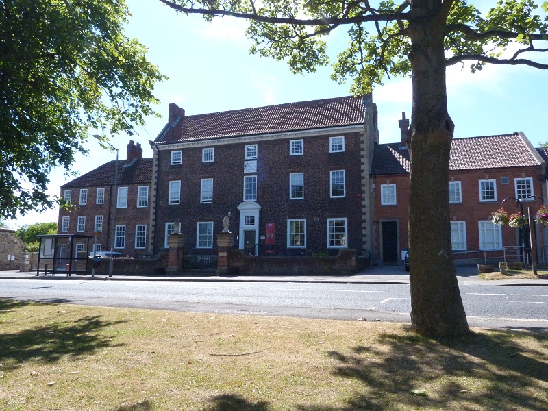
The Manor House, Sedgefield

The Manor House in Sedgefield, County Durham was built in 1707 on high ground in a country setting looking on to St. Edmund's Church as a mansion house...

Nearby Amenities

Located within 500m of 54.64802,-1.4729636
Bus Stop
Sands Farm
Naptan AtcoCode: 13006529C
Naptan Bearing: E
Naptan CommonName: Sands Farm
Naptan Indicator: east bound
Naptan Landmark: Landmark not known
Naptan NaptanCode: durdpapg
Naptan Notes: On road A689- Sandy Bank- Bradbury and The Isle
Naptan Street: A689
Naptan Verified: no
Source: naptan_import
Lat/Long: 54.6499001/-1.4755913
Bus Stop
Sands Farm
Naptan AtcoCode: 13006529G
Naptan Bearing: W
Naptan CommonName: Sands Farm
Naptan Indicator: west bound
Naptan Landmark: Landmark not known
Naptan NaptanCode: durdpapj
Naptan Notes: On road A689- opposite Sandy Bank- Bradbury and The Isle
Naptan Street: A689
Naptan Verified: no
Source: naptan_import
Lat/Long: 54.6497832/-1.4755773
The data included in this document is from www.openstreetmap.org. The data is made available under ODbL.

Have you been to Bath Plantation?

Leave your review of Bath Plantation below (or comments, questions and feedback).