Dinder

Settlement in Somerset Mendip

England

Dinder

2011 : Old road through Croscombe The old road through Croscombe, now cut off by the A371.
Valerian grows at the bottom of the wall on the left, too attractive to be a weed, more of an unofficial floral display. Kniphofia (red hot poker) shows in the cottage garden.
2011 : Old road through Croscombe Credit: Maurice Pullin

Dinder is a picturesque village located in the county of Somerset, England. Nestled in the Mendip Hills, it lies approximately 4 miles east of the city of Wells. The village is surrounded by stunning countryside, offering breathtaking views and a tranquil atmosphere.

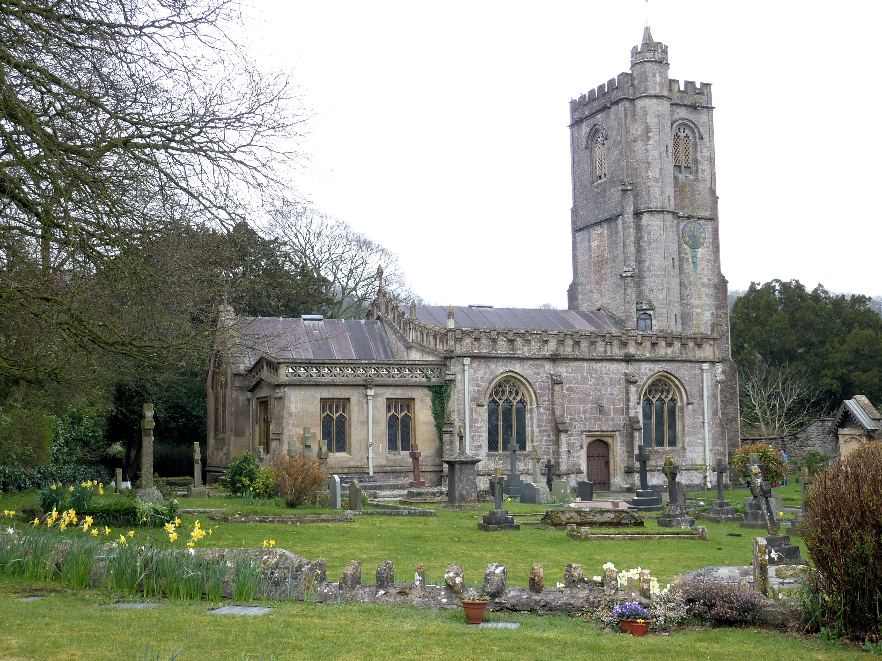
Dinder is a small and close-knit community, with a population of around 200 residents. It is known for its charming and well-preserved historic buildings, including the Grade II listed St. Michael's Church, which dates back to the 15th century. The church features beautiful stained-glass windows and a peaceful churchyard.

The village is also home to Dinder House, an elegant Georgian mansion that was built in the 18th century. The house boasts magnificent architecture and is set within extensive grounds. It is privately owned and not open to the public, but its grandeur can still be admired from a distance.

Dinder is surrounded by lush countryside, making it an ideal location for nature lovers and outdoor enthusiasts. There are several walking and cycling paths in the area, allowing visitors to explore the stunning landscapes and enjoy the tranquility of the Somerset countryside.

Despite its small size, Dinder has a strong community spirit and a range of local amenities. The village has a primary school, a village hall, and a pub, providing residents with essential services and opportunities for socializing.

Overall, Dinder is a charming and idyllic village, offering a peaceful escape from the hustle and bustle of city life. Its stunning natural surroundings and historic architecture make it a hidden gem in the heart of Somerset.

If you have any feedback on the listing, please let us know in the comments section below.

Dinder Images

Images are sourced within 2km of 51.19989/-2.605682 or Grid Reference ST5744. Thanks to Geograph Open Source API. All images are credited.

2011 : Old road through Croscombe The old road through Croscombe, now cut off by the A371.
Valerian grows at the bottom of the wall on the left, too attractive to be a weed, more of an unofficial floral display. Kniphofia (red hot poker) shows in the cottage garden.
2011 : Old road through Croscombe
The old road through Croscombe, now cut off by the A371. Valerian grows at the bottom of the wall on the left, too attractive to be a weed, more of an unofficial floral display. Kniphofia (red hot poker) shows in the cottage garden.
2011 : Mendip valley south of Croscombe From a field adjoining the Old Wells Road.
The valley is not named on OS Explorer 141, but of greater interest, Glastonbury Tor <a href="https://www.geograph.org.uk/gridref/ST5138">ST5138</a> sits on the horizon.
2011 : Mendip valley south of Croscombe
From a field adjoining the Old Wells Road. The valley is not named on OS Explorer 141, but of greater interest, Glastonbury Tor ST5138 sits on the horizon.
2011 : A371 at Croscombe On the way to Wells at the end of Duncart Lane.
2011 : A371 at Croscombe
On the way to Wells at the end of Duncart Lane.
2011 : Duncart Lane, Croscombe Duncart Lane, Croscombe.
Leads to the Old Wells Road at the top of the hill.
Wonder why the driver of that C1 abandoned his vehicle in the middle of the road like that.
2011 : Duncart Lane, Croscombe
Duncart Lane, Croscombe. Leads to the Old Wells Road at the top of the hill. Wonder why the driver of that C1 abandoned his vehicle in the middle of the road like that.
2011 : Possible land fill site at the top of Duncart Lane The Pen Hill TV transmitter north of Wells can be seen. <a href="https://www.geograph.org.uk/gridref/ST5648">ST5648</a>
2011 : Possible land fill site at the top of Duncart Lane
The Pen Hill TV transmitter north of Wells can be seen. ST5648
2011 : Duncart Lane, heading to Croscombe A few houses in the village are visible, and the Church spire.
2011 : Duncart Lane, heading to Croscombe
A few houses in the village are visible, and the Church spire.
2011 : Dungeon Farm and herd South of Croscombe.
Seen from a footpath near the Old Wells Road.
2011 : Dungeon Farm and herd
South of Croscombe. Seen from a footpath near the Old Wells Road.
2011 : North east at the top of Duncart Lane At the top of the hill south of Croscombe.
The landscape here looks almost flat, but we are looking across the tops of the Mendips with some fairly deep valleys in between.
2011 : North east at the top of Duncart Lane
At the top of the hill south of Croscombe. The landscape here looks almost flat, but we are looking across the tops of the Mendips with some fairly deep valleys in between.
Path by the rugby pitch See <a href="https://www.geograph.org.uk/photo/540254">ST5645 : Rugby ground</a>. This is footpath WS 17/12. On the right is the steep Strawberry Wood.
Path by the rugby pitch
See ST5645 : Rugby ground. This is footpath WS 17/12. On the right is the steep Strawberry Wood.
Wells Golf Club Crossed by footpath WS 10/45C, and, according to the map I was carrying (2004 vintage) by footpath WS 10/44, though not according to the club members I encountered en route. Above is King's Castle Wood.
Wells Golf Club
Crossed by footpath WS 10/45C, and, according to the map I was carrying (2004 vintage) by footpath WS 10/44, though not according to the club members I encountered en route. Above is King's Castle Wood.
Wells Golf Club The northwestern corner of the course, with the clubhouse visible in the distance.
Wells Golf Club
The northwestern corner of the course, with the clubhouse visible in the distance.
South Lodge to Mendip Hospital Another view of <a href="https://www.geograph.org.uk/photo/577090">ST5646 : Porter's Lodge, Wells</a>. Built about 1845 and described at <span class="nowrap"><a title="http://www.britishlistedbuildings.co.uk/en-268200-south-lodge-to-mendip-hospital-st-cuthbe" rel="nofollow ugc noopener" href="http://www.britishlistedbuildings.co.uk/en-268200-south-lodge-to-mendip-hospital-st-cuthbe">Link</a><img style="margin-left:2px;" alt="External link" title="External link - shift click to open in new window" src="https://s1.geograph.org.uk/img/external.png" width="10" height="10"/></span> . In the foreground is the Old Frome Road; to the left it meets the B3139 Bath Road.
South Lodge to Mendip Hospital
Another view of ST5646 : Porter's Lodge, Wells. Built about 1845 and described at LinkExternal link . In the foreground is the Old Frome Road; to the left it meets the B3139 Bath Road.
Old Frome Road near South Horrington Some of the new housing close to the road east of Wells. The road to the left is called Gilbert Scott Road, acknowledging the famous Victorian architect who jointly designed the former Mendip Hospital to which the road leads.
Old Frome Road near South Horrington
Some of the new housing close to the road east of Wells. The road to the left is called Gilbert Scott Road, acknowledging the famous Victorian architect who jointly designed the former Mendip Hospital to which the road leads.
Dry valley near South Horrington Crossed by footpath WS 10/46, which climbs the hill behind the large oak right of centre.
Dry valley near South Horrington
Crossed by footpath WS 10/46, which climbs the hill behind the large oak right of centre.
Fields near Great War Plantation A view from footpath WS 10/46, looking towards Combe Cottage between a meadow and a maize field.
Fields near Great War Plantation
A view from footpath WS 10/46, looking towards Combe Cottage between a meadow and a maize field.
Approaching The Warren Bridleway WS 4/15 converges with bridleway WS 4/16 to pass through the gate on the north side of The Warren, the wood to the right. Beyond the gate, the public road (Lyatt Lane) begins.
Approaching The Warren
Bridleway WS 4/15 converges with bridleway WS 4/16 to pass through the gate on the north side of The Warren, the wood to the right. Beyond the gate, the public road (Lyatt Lane) begins.
Lane to Dinder Taken just south of West Lodge on the lane down from Lyatt.
Lane to Dinder
Taken just south of West Lodge on the lane down from Lyatt.
Gates to Sharcombe Park And impressive gateposts. The left-hand one is probably a metre into <a href="https://www.geograph.org.uk/gridref/ST5745">ST5745</a>. Over the hedge is the West Lodge.
Gates to Sharcombe Park
And impressive gateposts. The left-hand one is probably a metre into ST5745. Over the hedge is the West Lodge.
Show me another place!

Dinder is located at Grid Ref: ST5744 (Lat: 51.19989, Lng: -2.605682)

Administrative County: Somerset

District: Mendip

Police Authority: Avon and Somerset

What 3 Words

///craftsmen.aimlessly.cherish. Near Wells, Somerset

Nearby Locations

Dinder Dulcote Hill

Related Wikis

Dinder

Dinder (which means "the house in the valley") is a small village and former civil parish, now in the parish of St Cuthbert Out, in the Somerset district...

Dinder House

Dinder House, is a Somerset estate with a small country house Grade II Regency listed building in the village of Dinder, in the civil parish of St Cuthbert...

Church of St Michael, Dinder

The Anglican Church of St Michael in Dinder, Somerset, England has Norman origins and was built in the 14th century before being rebuilt in the 15th. It...

Dulcote Quarry

Dulcote Quarry is a disused limestone quarry at Dulcote, near Wells on the Mendip Hills, Somerset, England. The quarry measures around 600 metres (2,000...

King's Castle, Wells

King's Castle is an Iron Age enclosed hilltop settlement at the south-western edge of the Mendip Hills near Wells in Somerset, England. Though there are...

The Old Rectory, Croscombe

The Old Rectory in the village of Croscombe within the English county of Somerset was built in the 17th century and rebuilt in the 18th. It is a Grade...

The Old Manor, Croscombe

The Old Manor in Croscombe, Somerset, England, was built around 1460–89 as a rectorial manor house for Hugh Sugar, the Treasurer of Wells Cathedral. It...

Horrington

Horrington is a collection of three small villages (South Horrington, East Horrington and West Horrington) in the parish of St Cuthbert Out 1 mile (2 km...

Nearby Amenities

Located within 500m of 51.19989,-2.605682
Dinder
Place: village
Wikidata: Q5277989
Wikipedia: en:Dinder
Lat/Long: 51.1990383/-2.608341
Closed security gate with no access
Lat/Long: 51.1983749/-2.6085462
Public Bookcase
Booth: K6
Disused Amenity: telephone
Man Made: telephone_box
Public Bookcase Type: phone_box
Lat/Long: 51.1990508/-2.6084925
Defibrillator
Defibrillator Location: outside Dinder Village Hall
Emergency: defibrillator
Indoor: no
Lat/Long: 51.200337/-2.608971
The data included in this document is from www.openstreetmap.org. The data is made available under ODbL.

Have you been to Dinder?

Leave your review of Dinder below (or comments, questions and feedback).