Dihewyd

Settlement in Cardiganshire

Wales

Dihewyd

Churn Stand
Churn Stand Credit: Adrian Dust

Dihewyd is a small village located in the county of Cardiganshire, Wales. Situated in the central part of the county, it lies approximately 8 miles southeast of the town of Aberystwyth and is surrounded by picturesque countryside.

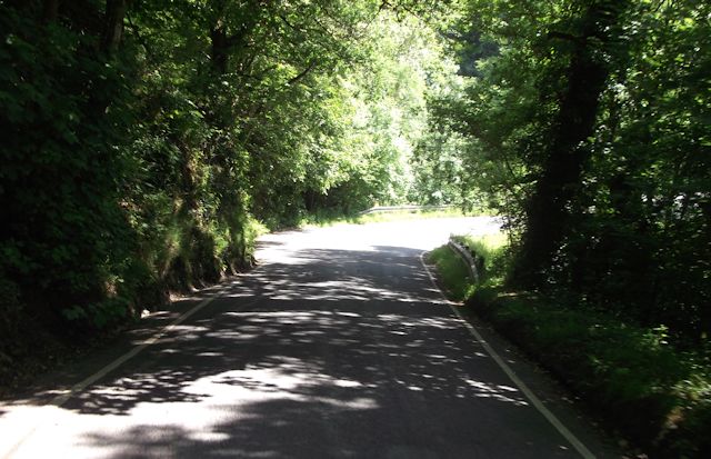
The village is known for its rural charm and natural beauty. The landscape is characterized by rolling hills, green fields, and scattered farms, providing a peaceful and idyllic setting. Dihewyd is also blessed with proximity to the stunning coastline of Cardigan Bay, which is only a few miles to the west.

The village itself is small and tight-knit, with a population of around 300 residents. It has a strong sense of community, and the locals take great pride in maintaining the beauty and tranquility of their surroundings. The village features a few amenities, including a local pub, a primary school, and a community hall.

Historically, Dihewyd has been an agricultural community, with farming playing a vital role in the local economy. However, like many rural areas, it has experienced some changes over the years, with diversification into other sectors such as tourism and small-scale businesses.

For those seeking outdoor activities, Dihewyd offers ample opportunities for walking, hiking, and exploring the scenic countryside. The nearby coast also provides opportunities for water sports and beach activities.

In conclusion, Dihewyd is a charming and peaceful village in Cardiganshire, Wales. With its rural beauty and strong community spirit, it offers a tranquil retreat for residents and visitors alike.

If you have any feedback on the listing, please let us know in the comments section below.

Dihewyd Images

Images are sourced within 2km of 52.180934/-4.215858 or Grid Reference SN4855. Thanks to Geograph Open Source API. All images are credited.

Churn Stand
Churn Stand
Ordnance Survey Cut Mark This OS cut mark can be found on the porch of St Vitalis Church. It marks a point 224.148m above mean sea level.
Ordnance Survey Cut Mark
This OS cut mark can be found on the porch of St Vitalis Church. It marks a point 224.148m above mean sea level.
Ordnance Survey Cut Mark This OS cut mark can be found on the churn stand NE side of the road. It marks a point 197.716m above mean sea level. <a title="https://www.geograph.org.uk/photo/7521144" href="https://www.geograph.org.uk/photo/7521144">Link</a>
Ordnance Survey Cut Mark
This OS cut mark can be found on the churn stand NE side of the road. It marks a point 197.716m above mean sea level. Link
Churn Stand There is an Ordnance Survey cut mark on the front of the stand. <a title="https://www.geograph.org.uk/photo/7521143" href="https://www.geograph.org.uk/photo/7521143">Link</a>
Churn Stand
There is an Ordnance Survey cut mark on the front of the stand. Link
Overhanging trees near Hampton On minor road heading south from Ty Nant
Overhanging trees near Hampton
On minor road heading south from Ty Nant
Bend at Maple Villa
Bend at Maple Villa
B4339 entering Dihewyd
Dihewyd road junction
B4342 approaching Ty'n-y-parc
B4342 approaching Arlen entrance
B4342 approaching sharp bend through the woods
Erection of buildings beside the B4342 I was unable to discover exactly what was being built from the Ceredigion County Council’s website so if anyone can provide me with more details, I’d be pleased to hear from them.
Erection of buildings beside the B4342
I was unable to discover exactly what was being built from the Ceredigion County Council’s website so if anyone can provide me with more details, I’d be pleased to hear from them.
Approaching Dihewyd from the SSW along the B4342
Field view from the Triangulation Pillar at Pen Moel Dihewyd Looking westward.
Field view from the Triangulation Pillar at Pen Moel Dihewyd
Looking westward.
Entrance to driveway to Ty-coch Farm
Eglwys St Vitalis, Dihewyd
Eglwys St Vitalis, Dihewyd, and graveyard
Eglwys St Vitalis, Dihewyd
Show me another place!

Dihewyd is located at Grid Ref: SN4855 (Lat: 52.180934, Lng: -4.215858)

Unitary Authority: Ceredigion

Police Authority: Dyfed Powys

What 3 Words

///ticked.regime.grove. Near Llanarth, Ceredigion

Nearby Locations

Dihewyd

Related Wikis

Dihewyd

Dihewyd is a parish in the county of Ceredigion, West Wales with a population of about 200 people. It is 5 miles (8 km) from Aberaeron and 8 miles (13...

Foelallt

Foelallt is a small village in the community of Ciliau Aeron, Ceredigion, Wales, which is 66.2 miles (106.6 km) from Cardiff and 180.2 miles (290 km)...

Green Grove, Ceredigion

Green Grove is a small village in the community of Llanfihangel Ystrad, Ceredigion, Wales, which is 64.9 miles (104.4 km) from Cardiff and 179.1 miles...

Mydroilyn

Mydroilyn is a village in the parish of Llanarth, Ceredigion, Wales, situated along the B4342 road. The name of the village is derived from the confluence...

Nearby Amenities

Located within 500m of 52.180934,-4.215858
Dihewyd
Is In: Ceredigion, Wales, UK
Place: village
Wikidata: Q5276401
Lat/Long: 52.1806685/-4.2198645
Siop y Shed
Shop: supermarket
Lat/Long: 52.1794589/-4.2134195
Post Box
Post Box Type: lamp
Royal Cypher: EIIR
Lat/Long: 52.1795645/-4.2154901
Bus Stop
bus stop
Naptan AtcoCode: 5230CGX16491
Naptan NaptanCode: cejapmw
Shelter: yes
Lat/Long: 52.1801332/-4.2150992
Entrance: yes
Lat/Long: 52.1815736/-4.2172271
Place Of Worship
Chapel
Religion: christian
Lat/Long: 52.181163/-4.2158639
Community playing fields
Leisure: common
Lat/Long: 52.1814933/-4.2179144
School
Ysgol Dihewyd
Lat/Long: 52.1794175/-4.2137571
Unicorn Construction
Building: yes
Lat/Long: 52.1813701/-4.2152286
Rhydian Lewis farm maintainance
Building: yes
Lat/Long: 52.1810791/-4.2152528
Power: pole
Lat/Long: 52.1771441/-4.2182377
Direction: SW
Generator Method: photovoltaic
Generator Output Electricity: yes
Generator Solar Modules: 12
Generator Source: solar
Generator Type: solar_photovoltaic_panel
Location: roof
Power: generator
Lat/Long: 52.1804779/-4.2162985
Direction: S
Generator Method: photovoltaic
Generator Output Electricity: yes
Generator Solar Modules: 14
Generator Source: solar
Generator Type: solar_photovoltaic_panel
Location: roof
Power: generator
Lat/Long: 52.1821571/-4.2174947
Give Way
Direction: backward
Lat/Long: 52.1803696/-4.2149724
Give Way
Direction: backward
Lat/Long: 52.1786577/-4.2116137
Give Way
Direction: backward
Lat/Long: 52.1780935/-4.2165603
Man Made: utility_pole
Lat/Long: 52.1794563/-4.2176313
The data included in this document is from www.openstreetmap.org. The data is made available under ODbL.

Have you been to Dihewyd?

Leave your review of Dihewyd below (or comments, questions and feedback).