Didmarton

Settlement in Gloucestershire Cotswold

England

Didmarton

Knockdown, Gloucester A view of Avenue Farm at Knockdown.
Knockdown, Gloucester Credit: Rebecca A Wills

Didmarton is a picturesque village located in the county of Gloucestershire, England. Situated in the Cotswold Area of Outstanding Natural Beauty, it offers a charming and tranquil setting for both residents and visitors. The village is nestled amidst rolling hills and surrounded by lush green countryside, which adds to its idyllic appeal.

Didmarton is a small village with a population of around 400 people. It is known for its traditional stone cottages, some of which date back to the 17th century, giving the village a distinct historic character. The village is centered around St. Michael's Church, a beautiful Grade II listed building that stands as a testament to the area's rich heritage.

Despite its small size, Didmarton offers a range of amenities to cater to the needs of its residents. These include a village hall, a primary school, and a local pub, which serves as a popular meeting place for locals and visitors alike.

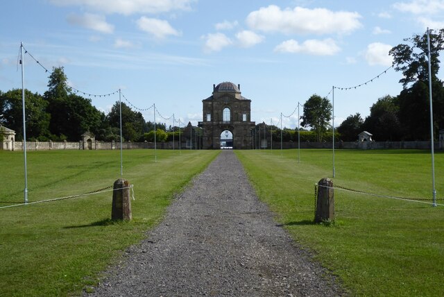
One of the highlights of Didmarton is the annual Badminton Horse Trials, an internationally renowned equestrian event that takes place in the nearby Badminton Estate. The event attracts thousands of spectators and competitors from around the world, adding a vibrant and exciting atmosphere to the village.

Nature enthusiasts will find plenty to explore in the surrounding area, with numerous walking and cycling trails that showcase the beauty of the Cotswolds. The village also benefits from its proximity to other charming towns and villages, such as Tetbury and Malmesbury, offering additional amenities and attractions for residents and visitors to enjoy.

In conclusion, Didmarton is a picturesque village nestled in the Cotswolds, offering a peaceful and historic setting surrounded by natural beauty. With its charming character, range of amenities, and proximity to other attractions, it is a delightful place to visit or call home.

If you have any feedback on the listing, please let us know in the comments section below.

Didmarton Images

Images are sourced within 2km of 51.58811/-2.258025 or Grid Reference ST8287. Thanks to Geograph Open Source API. All images are credited.

Knockdown, Gloucester A view of Avenue Farm at Knockdown.
Knockdown, Gloucester
A view of Avenue Farm at Knockdown.
Worcester Lodge Worcester Lodge was designed by William Kent in 1745 and completed in 1750 and is a lodge to Badminton House.
Worcester Lodge
Worcester Lodge was designed by William Kent in 1745 and completed in 1750 and is a lodge to Badminton House.
Didmarton : The Street A433 Looking along The Street.
Didmarton : The Street A433
Looking along The Street.
Didmarton : Oldbury on the Hill Looking towards buildings beyond the grassy field.
Didmarton : Oldbury on the Hill
Looking towards buildings beyond the grassy field.
Didmarton : Grassy Field Looking towards Oldbury.
Didmarton : Grassy Field
Looking towards Oldbury.
Didmarton : Track Looking along a muddy track.
Didmarton : Track
Looking along a muddy track.
Oldbury on the Hill, St. Arild's Church: Southern aspect
Oldbury on the Hill: A field of oil seed rape
Oldbury on the Hill, St. Arild's Church: The nave
Oldbury on the Hill, St. Arild's Church: The Holborow memorial
Oldbury on the Hill, St. Arild's Church: A small fragment of medieval wall painting
Oldbury on the Hill, St. Arild's Church: The Haynes memorial
Oldbury on the Hill, St. Arild's Church: Late c19th replica of the Norman font that was destroyed in the 1897 fire
Oldbury on the Hill, St. Arild's Church: The altar
Oldbury on the Hill, St. Arild's Church: The pews
Oldbury on the Hill, St. Arild's Church: The west window
Show me another place!

Didmarton is located at Grid Ref: ST8287 (Lat: 51.58811, Lng: -2.258025)

Administrative County: Gloucestershire

District: Cotswold

Police Authority: Gloucestershire

What 3 Words

///dial.under.prepped. Near Sherston, Wiltshire

Nearby Locations

Didmarton Joyce's Pool

Related Wikis

Oldbury-on-the-Hill

Oldbury-on-the-Hill is a small village and former civil parish, now in the parish of Didmarton, in the Cotswold district, in Gloucestershire, England,...

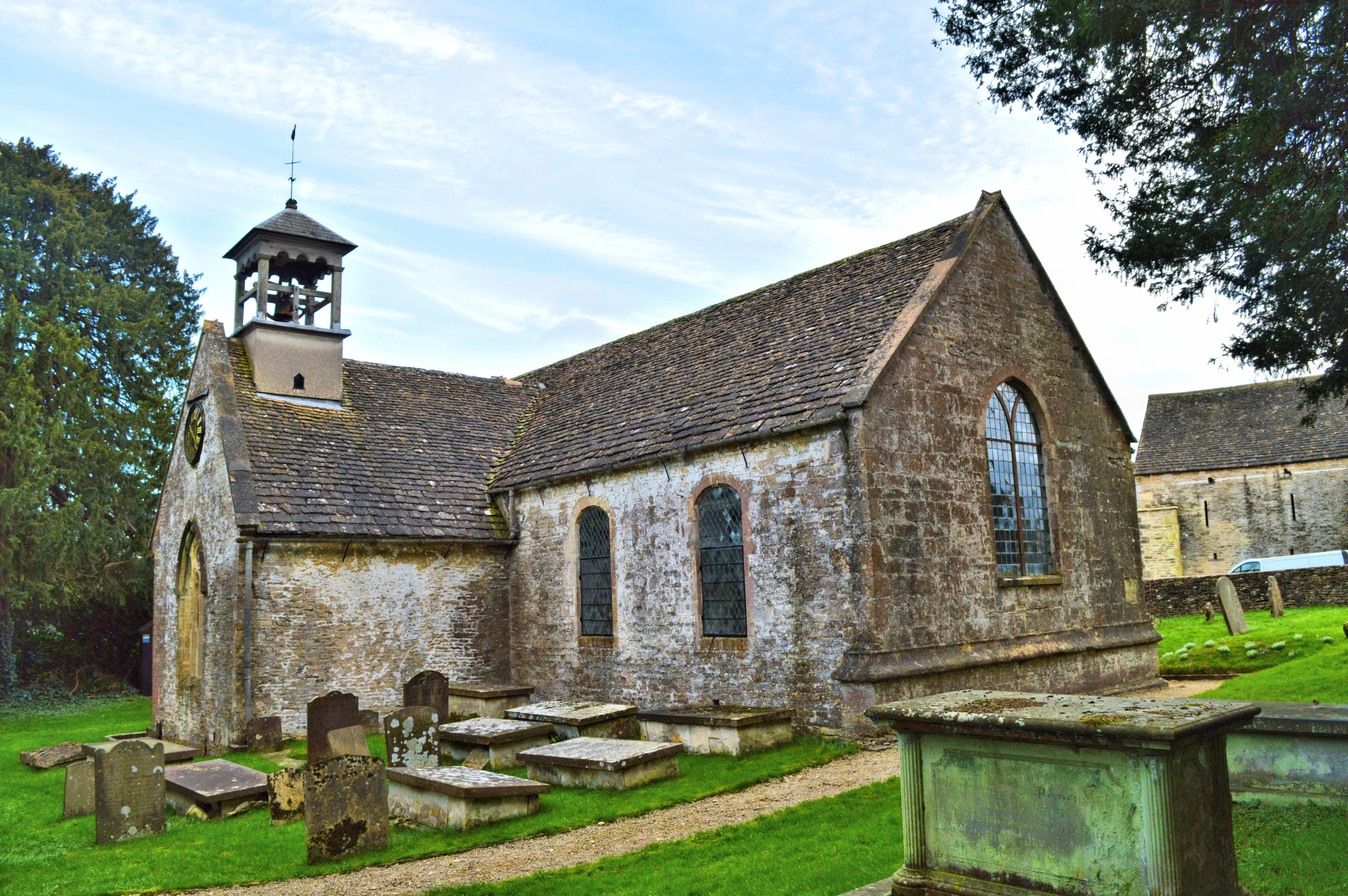
Church of St Lawrence, Didmarton

The Anglican Church of St Lawrence at Didmarton in the Cotswold District of Gloucestershire, England was built in the 13th century. It is a grade I listed...

Didmarton

Didmarton is a village and civil parish in Gloucestershire, England. It lies in the Cotswold District, about 6 miles (10 km) southwest of Tetbury. The...

St Arild's Church, Oldbury-on-the-Hill

St Arild's Church is a historic Anglican church near the village of Oldbury-on-the-Hill, Gloucestershire, England under the care of The Churches Conservation...

Nearby Amenities

Located within 500m of 51.58811,-2.258025
Didmarton
Is In: Gloucestershire, England, UK
Place: village
Postal Code: GL9 1
Lat/Long: 51.5853492/-2.2611943
Pub
The Kings Arms
Addr Country: GB
Addr Postcode: GL9 1DT
Addr Street: The Street
Addr Village: Didmarton
Fhrs Id: 9009
Outdoor Seating: yes
Wikidata: Q26625265
Lat/Long: 51.5856216/-2.2637496
Bus Stop
Sopworth Turn
Naptan AtcoCode: 1600GL1605
Naptan Bearing: SW
Naptan CommonName: Sopworth Turn
Naptan Indicator: Opp
Naptan NaptanCode: gloawmjt
Naptan Street: A433
Naptan Verified: no
Source: naptan_import
Lat/Long: 51.5885406/-2.2530089
Bus Stop
Sopworth Turn
Naptan AtcoCode: 1600GL1606
Naptan Bearing: NE
Naptan CommonName: Sopworth Turn
Naptan NaptanCode: gloawmjm
Naptan Street: A433
Naptan Verified: no
Source: naptan_import
Lat/Long: 51.5886751/-2.2531829
Telephone
Booth: K6
Covered: booth
Listed Status: Grade II
Operator: BT
Phone: +44 1454 238220
Lat/Long: 51.585661/-2.2640449
Post Box
Post Box Design: type_n
Post Box Type: lamp
Ref: GL9 155
Royal Cypher: EIIR
Royal Cypher Wikidata: Q33102113
Lat/Long: 51.5856666/-2.2640642
Rest Area
Lat/Long: 51.5886296/-2.2530985
Bench
Backrest: yes
Lat/Long: 51.5881073/-2.2552157
Defibrillator
Defibrillator Location: outside Kings Arms pub car park in Didmarton - next to phone box and post box
Emergency: defibrillator
Indoor: no
Lat/Long: 51.585669/-2.2640833
The data included in this document is from www.openstreetmap.org. The data is made available under ODbL.

Have you been to Didmarton?

Leave your review of Didmarton below (or comments, questions and feedback).