Diddington

Settlement in Huntingdonshire Huntingdonshire

England

Diddington

Diddington, St Laurence
Diddington, St Laurence Credit: Dave Kelly

Diddington is a small village located in the historic county of Huntingdonshire, in the eastern region of England. Situated approximately 5 miles southeast of the town of Huntingdon, Diddington is nestled amidst picturesque countryside and offers a peaceful and rural setting.

The village is characterized by its charming and idyllic atmosphere, with a population of around 200 residents. Diddington is renowned for its beautiful landscapes, including rolling hills, lush green fields, and the nearby River Great Ouse that adds to the scenic beauty of the area.

Historically, Diddington is notable for its connection to the St. Neots Priory, as the village was mentioned in the Domesday Book of 1086 as "Didingtone." The priory was an important religious institution during medieval times and played a significant role in shaping the local history.

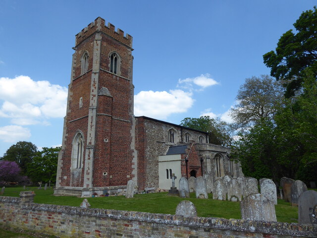
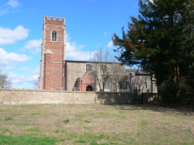
Today, Diddington retains its rural character, with a few scattered houses, a village hall, and a historic church dedicated to St. Laurence. The church, dating back to the 14th century, stands as a testament to the village's rich heritage.

Despite its small size, Diddington offers a close-knit community spirit, with various social events and activities taking place throughout the year. The village is a haven for nature enthusiasts, providing ample opportunities for walking, cycling, and exploring the surrounding countryside.

In summary, Diddington is a quaint and serene village, cherished for its natural beauty and historical significance, making it an ideal retreat for those seeking a peaceful countryside escape.

If you have any feedback on the listing, please let us know in the comments section below.

Diddington Images

Images are sourced within 2km of 52.27668/-0.25445 or Grid Reference TL1965. Thanks to Geograph Open Source API. All images are credited.

Diddington, St Laurence
George Lane, Buckden The half timbered building was formerly part of the George Hotel <span class="nowrap"><a title="https://historicengland.org.uk/listing/the-list/list-entry/1130322?section=official-list-entry" rel="nofollow ugc noopener" href="https://historicengland.org.uk/listing/the-list/list-entry/1130322?section=official-list-entry">Link</a><img style="margin-left:2px;" alt="External link" title="External link - shift click to open in new window" src="https://s1.geograph.org.uk/img/external.png" width="10" height="10"/></span>
George Lane, Buckden
The half timbered building was formerly part of the George Hotel LinkExternal link
Buckden Book Swap A former K6 telephone kiosk <span class="nowrap"><a title="https://historicengland.org.uk/listing/the-list/list-entry/1130255?section=official-list-entry" rel="nofollow ugc noopener" href="https://historicengland.org.uk/listing/the-list/list-entry/1130255?section=official-list-entry">Link</a><img style="margin-left:2px;" alt="External link" title="External link - shift click to open in new window" src="https://s1.geograph.org.uk/img/external.png" width="10" height="10"/></span>
Buckden Book Swap
A former K6 telephone kiosk LinkExternal link
The Lion Hotel, Buckden An eighteenth century exterior disguises a building of about 1500 <span class="nowrap"><a title="https://historicengland.org.uk/listing/the-list/list-entry/1309969?section=official-list-entry" rel="nofollow ugc noopener" href="https://historicengland.org.uk/listing/the-list/list-entry/1309969?section=official-list-entry">Link</a><img style="margin-left:2px;" alt="External link" title="External link - shift click to open in new window" src="https://s1.geograph.org.uk/img/external.png" width="10" height="10"/></span>
The Lion Hotel, Buckden
An eighteenth century exterior disguises a building of about 1500 LinkExternal link
The George Hotel, Buckden The hotel has been reduced in size and much is now occupied by other businesses. Much of the building dates from c1722 <span class="nowrap"><a title="https://historicengland.org.uk/listing/the-list/list-entry/1330406?section=official-list-entry" rel="nofollow ugc noopener" href="https://historicengland.org.uk/listing/the-list/list-entry/1330406?section=official-list-entry">Link</a><img style="margin-left:2px;" alt="External link" title="External link - shift click to open in new window" src="https://s1.geograph.org.uk/img/external.png" width="10" height="10"/></span>
The George Hotel, Buckden
The hotel has been reduced in size and much is now occupied by other businesses. Much of the building dates from c1722 LinkExternal link
Former farmhouse, Buckden Dates from the seventeenth century with later additions and alterations <span class="nowrap"><a title="https://historicengland.org.uk/listing/the-list/list-entry/1330419?section=official-list-entry" rel="nofollow ugc noopener" href="https://historicengland.org.uk/listing/the-list/list-entry/1330419?section=official-list-entry">Link</a><img style="margin-left:2px;" alt="External link" title="External link - shift click to open in new window" src="https://s1.geograph.org.uk/img/external.png" width="10" height="10"/></span>
Former farmhouse, Buckden
Dates from the seventeenth century with later additions and alterations LinkExternal link
Luck's Cottage, Buckden Early nineteenth century house <span class="nowrap"><a title="https://historicengland.org.uk/listing/the-list/list-entry/1130318?section=official-list-entry" rel="nofollow ugc noopener" href="https://historicengland.org.uk/listing/the-list/list-entry/1130318?section=official-list-entry">Link</a><img style="margin-left:2px;" alt="External link" title="External link - shift click to open in new window" src="https://s1.geograph.org.uk/img/external.png" width="10" height="10"/></span>
Luck's Cottage, Buckden
Early nineteenth century house LinkExternal link
The Old Vicarage, Buckden The front part of the house dates from 1795 <span class="nowrap"><a title="https://historicengland.org.uk/listing/the-list/list-entry/1130319?section=official-list-entry" rel="nofollow ugc noopener" href="https://historicengland.org.uk/listing/the-list/list-entry/1130319?section=official-list-entry">Link</a><img style="margin-left:2px;" alt="External link" title="External link - shift click to open in new window" src="https://s1.geograph.org.uk/img/external.png" width="10" height="10"/></span>
The Old Vicarage, Buckden
The front part of the house dates from 1795 LinkExternal link
Cottages, Luck's Lane, Buckden Mainly of the eighteenth century.
Cottages, Luck's Lane, Buckden
Mainly of the eighteenth century.
War memorial, church, palace, Buckden The church at Buckden is by no means small but in some views it seems overwhelmed by the palace.
War memorial, church, palace, Buckden
The church at Buckden is by no means small but in some views it seems overwhelmed by the palace.
Outer gateway, Buckden Palace Dates from the late fifteenth century when Buckden Palace was a residence of the Bishop of Lincoln <span class="nowrap"><a title="https://historicengland.org.uk/listing/the-list/list-entry/1161771?section=official-list-entry" rel="nofollow ugc noopener" href="https://historicengland.org.uk/listing/the-list/list-entry/1161771?section=official-list-entry">Link</a><img style="margin-left:2px;" alt="External link" title="External link - shift click to open in new window" src="https://s1.geograph.org.uk/img/external.png" width="10" height="10"/></span>
Outer gateway, Buckden Palace
Dates from the late fifteenth century when Buckden Palace was a residence of the Bishop of Lincoln LinkExternal link
The Inner Gatehouse, Buckden Palace Dates from the late fifteenth century when the Palace was a residence of the Bishop of Lincoln <span class="nowrap"><a title="https://historicengland.org.uk/listing/the-list/list-entry/1130290?section=official-list-entry" rel="nofollow ugc noopener" href="https://historicengland.org.uk/listing/the-list/list-entry/1130290?section=official-list-entry">Link</a><img style="margin-left:2px;" alt="External link" title="External link - shift click to open in new window" src="https://s1.geograph.org.uk/img/external.png" width="10" height="10"/></span>
The Inner Gatehouse, Buckden Palace
Dates from the late fifteenth century when the Palace was a residence of the Bishop of Lincoln LinkExternal link
Outer gateway and boundary wall, Buckden Palace Largely of the fifteenth century <span class="nowrap"><a title="https://historicengland.org.uk/listing/the-list/list-entry/1161771?section=official-list-entry" rel="nofollow ugc noopener" href="https://historicengland.org.uk/listing/the-list/list-entry/1161771?section=official-list-entry">Link</a><img style="margin-left:2px;" alt="External link" title="External link - shift click to open in new window" src="https://s1.geograph.org.uk/img/external.png" width="10" height="10"/></span>
Outer gateway and boundary wall, Buckden Palace
Largely of the fifteenth century LinkExternal link
Buckden : redundant postal letter box
Southoe : Church of St Leonard Grade I listed - <span class="nowrap"><a title="https://historicengland.org.uk/listing/the-list/list-entry/1130254?section=official-list-entry" rel="nofollow ugc noopener" href="https://historicengland.org.uk/listing/the-list/list-entry/1130254?section=official-list-entry">Link</a><img style="margin-left:2px;" alt="External link" title="External link - shift click to open in new window" src="https://s1.geograph.org.uk/img/external.png" width="10" height="10"/></span>.
Southoe : Church of St Leonard
Grade I listed - LinkExternal link.
Buckden : Parish Church of St Mary Grade I listed - <span class="nowrap"><a title="https://historicengland.org.uk/listing/the-list/list-entry/1330416?section=official-list-entry" rel="nofollow ugc noopener" href="https://historicengland.org.uk/listing/the-list/list-entry/1330416?section=official-list-entry">Link</a><img style="margin-left:2px;" alt="External link" title="External link - shift click to open in new window" src="https://s1.geograph.org.uk/img/external.png" width="10" height="10"/></span>.
Buckden : Parish Church of St Mary
Grade I listed - LinkExternal link.
Buckden : almshouses, Church Street Grade II listed - dated 1840 on plaque and inscribed 'Industry Rewarded Age Protected'. <span class="nowrap"><a title="https://historicengland.org.uk/listing/the-list/list-entry/1130316?section=official-list-entry" rel="nofollow ugc noopener" href="https://historicengland.org.uk/listing/the-list/list-entry/1130316?section=official-list-entry">Link</a><img style="margin-left:2px;" alt="External link" title="External link - shift click to open in new window" src="https://s1.geograph.org.uk/img/external.png" width="10" height="10"/></span>
Buckden : almshouses, Church Street
Grade II listed - dated 1840 on plaque and inscribed 'Industry Rewarded Age Protected'. LinkExternal link
Buckden : Buckden Methodist Church "The Church was opened in July 1876 and the Schoolroom was added in 1911. It has been in continuous use ever since." - <span class="nowrap"><a title="https://eangliamethodist.org.uk/buckden" rel="nofollow ugc noopener" href="https://eangliamethodist.org.uk/buckden">Link</a><img style="margin-left:2px;" alt="External link" title="External link - shift click to open in new window" src="https://s1.geograph.org.uk/img/external.png" width="10" height="10"/></span>.
Buckden : Buckden Methodist Church
"The Church was opened in July 1876 and the Schoolroom was added in 1911. It has been in continuous use ever since." - LinkExternal link.
Show me another place!

Diddington is located at Grid Ref: TL1965 (Lat: 52.27668, Lng: -0.25445)

Administrative County: Cambridgeshire

District: Huntingdonshire

Police Authority: Cambridgeshire

What 3 Words

///soon.audio.skippers. Near Buckden, Cambridgeshire

Nearby Locations

Diddington Diddington

Related Wikis

Diddington

Diddington is a small village and civil parish in Cambridgeshire, England. Diddington lies approximately 5 miles (8 km) south-west of Huntingdon, near...

Buckden, Cambridgeshire

Buckden is a village and civil parish 3.7 miles (6.0 km) north of St Neots and 4 miles (6.4 km) south-west of Huntingdon, England. It includes the hamlets...

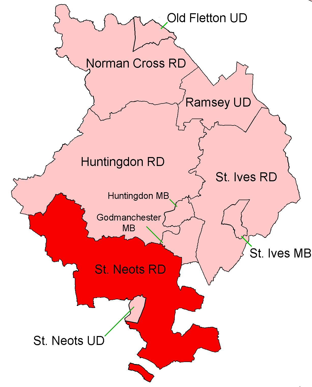
St Neots Rural District

St Neots was a rural district in Huntingdonshire, England from 1894 to 1974, around the northern and eastern sides of the urban area of St Neots. The district...
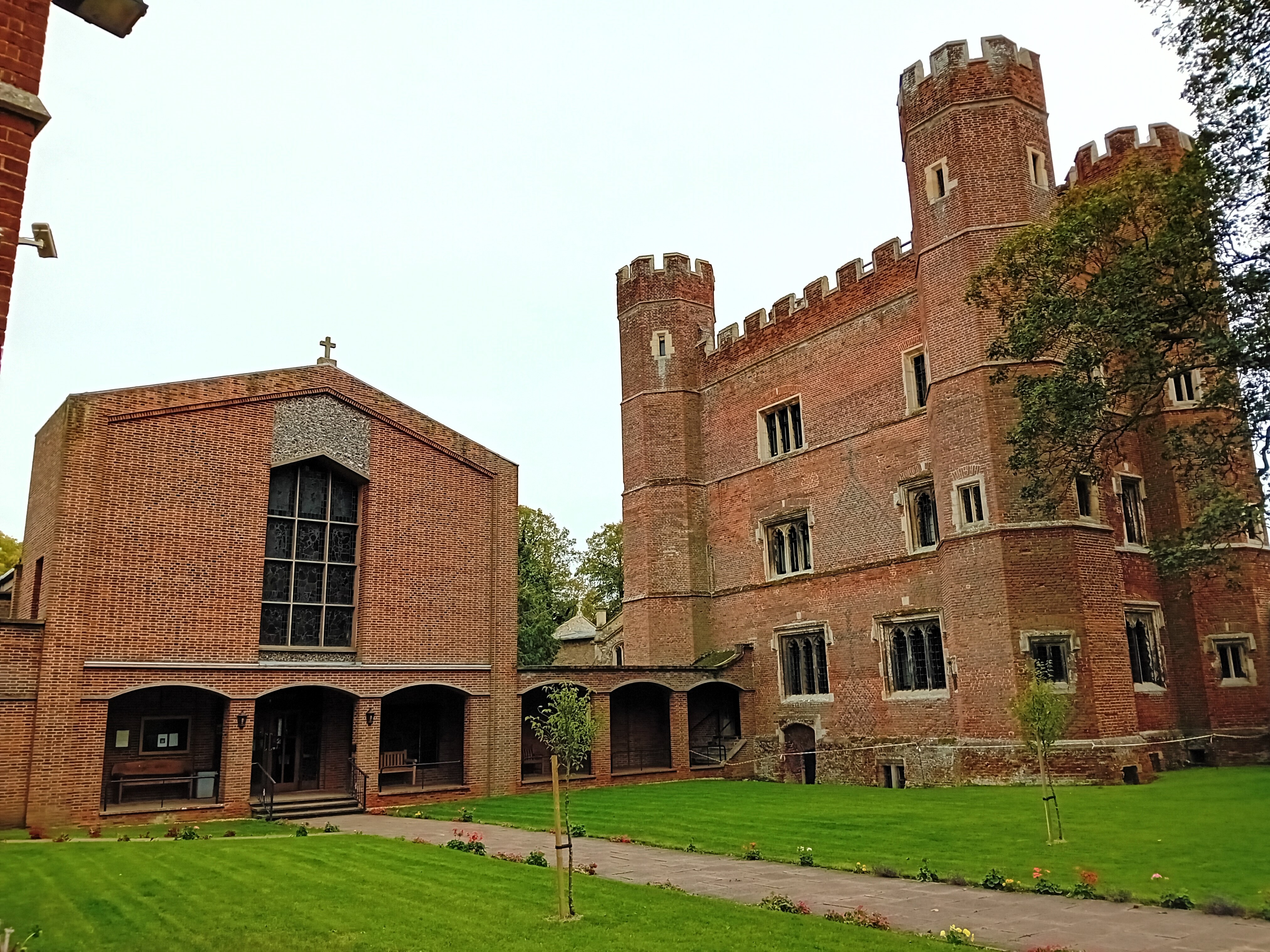
Buckden Towers

Buckden Towers, formerly known as Buckden Palace, is a medieval fortified house and bishop's palace in Buckden, Cambridgeshire, England. It is now a conference...

Nearby Amenities

Located within 500m of 52.27668,-0.25445
Created By: Merkaartor 0.12
Lat/Long: 52.2763029/-0.253189
Bus Stop
Diddington Road
Bus: yes
Naptan AtcoCode: 0500HDIDD001
Naptan Bearing: S
Naptan CommonName: Diddington Road
Naptan Indicator: near
Naptan Landmark: Diddington Road
Naptan NaptanCode: cmbdmwdt
Naptan ShortCommonName: Diddington Road
Naptan Street: Great North Road
Naptan Verified: no
Public Transport: platform
Shelter: no
Source: naptan_import
Lat/Long: 52.2766035/-0.2582542
Bus Stop
Diddington Road
Bus: yes
Naptan AtcoCode: 0500HDIDD002
Naptan Bearing: N
Naptan BusStopType: CUS
Naptan CommonName: Diddington Road
Naptan Indicator: opp
Naptan Landmark: Lodge Farm Road
Naptan NaptanCode: cmbdmwdw
Naptan ShortCommonName: Diddington Road
Naptan Street: Great North Road
Naptan Verified: no
Public Transport: platform
Shelter: no
Source: naptan_import
Lat/Long: 52.2769521/-0.2587242
Power: pole
Lat/Long: 52.2741255/-0.2512099
Power: pole
Lat/Long: 52.2744537/-0.252712
Power: pole
Lat/Long: 52.2747918/-0.2559523
Power: pole
Lat/Long: 52.2749559/-0.2575295
Power: pole
Lat/Long: 52.2752874/-0.2605979
Material: wood
Power: pole
Lat/Long: 52.2751297/-0.2591012
Power: pole
Lat/Long: 52.2746341/-0.2543696
Addr City: St Neots
Addr Housenumber: 26
Addr Postcode: PE19 5XU
Addr Street: The Street
Lat/Long: 52.2761516/-0.2531347
Addr City: St Neots
Addr Housenumber: 25
Addr Postcode: PE19 5XU
Addr Street: The Street
Lat/Long: 52.2761073/-0.2530448
Post Box
Post Box Type: lamp
Royal Cypher: EIIR
Royal Cypher Wikidata: Q33102113
Lat/Long: 52.2765188/-0.2537679
Addr City: St Neots
Addr Housenumber: 27
Addr Postcode: PE19 5XU
Addr Street: The Street
Lat/Long: 52.2761967/-0.2532205
Fingerpost: footpath
Lat/Long: 52.2772382/-0.2588564
Power: pole
Lat/Long: 52.2738199/-0.2496949
Crossing
Lat/Long: 52.2767815/-0.2581562
The data included in this document is from www.openstreetmap.org. The data is made available under ODbL.

Have you been to Diddington?

Leave your review of Diddington below (or comments, questions and feedback).