Victoria Spinney

Wood, Forest in Warwickshire Warwick

England

Victoria Spinney

The Green Man public house, Kenilworth
The Green Man public house, Kenilworth Credit: Ian S

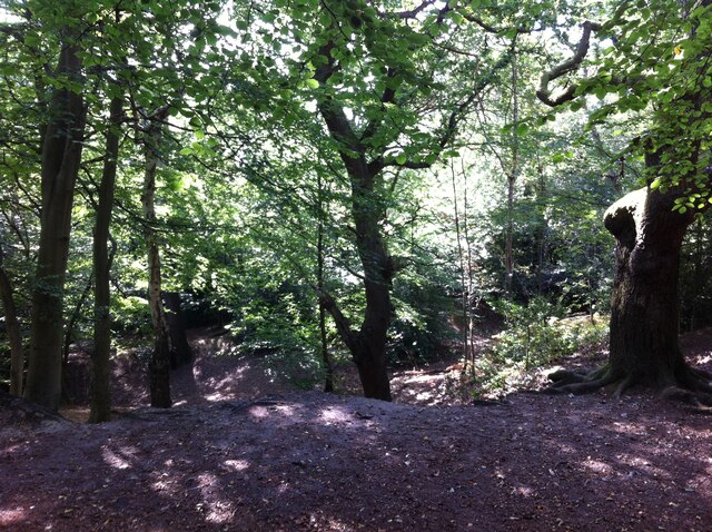
Victoria Spinney is a picturesque woodland located in Warwickshire, England. Situated in the heart of the county, this charming forest is a popular destination for nature lovers and outdoor enthusiasts alike. With its serene atmosphere and diverse range of flora and fauna, Victoria Spinney offers visitors a tranquil escape from the hustle and bustle of everyday life.

Covering an area of approximately 100 acres, the woodland is characterized by its dense canopy of towering trees, creating a shaded oasis perfect for leisurely strolls and picnics. The forest floor is adorned with a carpet of wildflowers and ferns, adding a splash of color to the otherwise green landscape.

The forest is home to a rich variety of wildlife, including rare birds, small mammals, and insects. Birdwatchers will delight in spotting species such as woodpeckers, owls, and songbirds, while nature enthusiasts may come across rabbits, squirrels, and even deer during their explorations.

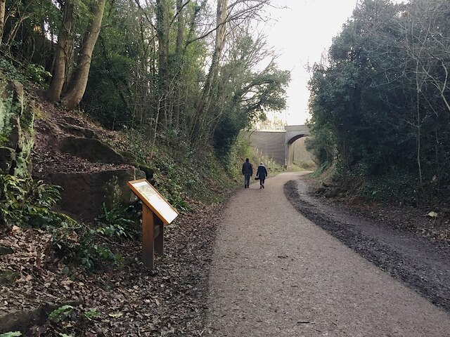
Victoria Spinney is also equipped with well-maintained walking trails that wind through the forest, providing visitors with the opportunity to fully immerse themselves in the natural surroundings. The paths are suitable for all levels of fitness, making the woodland accessible to individuals of all ages and abilities.

For those seeking a more adventurous experience, the forest offers opportunities for activities such as cycling, horseback riding, and orienteering. The expansive space and varied terrain make Victoria Spinney an ideal location for outdoor pursuits and team-building exercises.

Overall, Victoria Spinney in Warwickshire is a hidden gem that showcases the beauty of nature in the heart of England. Whether it's a peaceful walk, a family day out, or an active adventure, this enchanting woodland has something to offer everyone.

If you have any feedback on the listing, please let us know in the comments section below.

Victoria Spinney Images

Images are sourced within 2km of 52.345352/-1.5522496 or Grid Reference SP3072. Thanks to Geograph Open Source API. All images are credited.

The Green Man public house, Kenilworth
Clarke's Avenue, Kenilworth
Vicarage Gardens off Rouncil Lane, Kenilworth
Making a deck, The Engine public house, Mill End, Kenilworth In the later phase of the pandemic, pubs that had had to close invested in creating outdoor space so that they could safely serve socially-distanced patrons.
Making a deck, The Engine public house, Mill End, Kenilworth
In the later phase of the pandemic, pubs that had had to close invested in creating outdoor space so that they could safely serve socially-distanced patrons.
Kenilworth Greenway turns south, Crackley, Kenilworth The Greenway was created on a former railway line. The information board has accounts of the Kenilworth Sandstone, exposed here, and of the railway.
Kenilworth Greenway turns south, Crackley, Kenilworth
The Greenway was created on a former railway line. The information board has accounts of the Kenilworth Sandstone, exposed here, and of the railway.
Odibourne Allotments, Manor Road, Kenilworth The allotments were open to the public for the Heritage Open Days 2021 and Edible England events; members of the Kenilworth Allotment Tenants' Association (KATA) can be seen welcoming visitors. 

The Odibourne site was established in 1919, when Kenilworth Urban District Council bought land from the estate of the deceased William Thomas Pears. The council had recently decided to build on the 'Noah's Ark' allotments nearby, but was obliged under the 1908 Smallholding & Allotments Act to provide sufficient land for local people who wanted plots for growing food. The site is owned today by Kenilworth Town Council, but has been managed since 1983 by KATA (information taken from a notice board on the site).
Odibourne Allotments, Manor Road, Kenilworth
The allotments were open to the public for the Heritage Open Days 2021 and Edible England events; members of the Kenilworth Allotment Tenants' Association (KATA) can be seen welcoming visitors. The Odibourne site was established in 1919, when Kenilworth Urban District Council bought land from the estate of the deceased William Thomas Pears. The council had recently decided to build on the 'Noah's Ark' allotments nearby, but was obliged under the 1908 Smallholding & Allotments Act to provide sufficient land for local people who wanted plots for growing food. The site is owned today by Kenilworth Town Council, but has been managed since 1983 by KATA (information taken from a notice board on the site).
Plot 58a, Odibourne Allotments, Kenilworth These allotments, which to this city dweller appear impossibly idyllic, were open to the public for the Heritage Open Days 2021. Behind the idyll, of course, lies hard work and long term commitment, the challenge of group politics, the uncertainty of the weather and the threat, even here, of theft and vandalism. The Odibourne allotments were established in 1919.
Plot 58a, Odibourne Allotments, Kenilworth
These allotments, which to this city dweller appear impossibly idyllic, were open to the public for the Heritage Open Days 2021. Behind the idyll, of course, lies hard work and long term commitment, the challenge of group politics, the uncertainty of the weather and the threat, even here, of theft and vandalism. The Odibourne allotments were established in 1919.
I'm in the Green Zone A scarecrow, probably more decorative than functional, at the Odibourne allotments in Kenilworth, which were open to the public for the Heritage Open Days 2021.
I'm in the Green Zone
A scarecrow, probably more decorative than functional, at the Odibourne allotments in Kenilworth, which were open to the public for the Heritage Open Days 2021.
Apple Pressing at Odibourne Allotments, Kenilworth The allotment site was open to the public as part of the Heritage Open Days 2021 and Edible England events.
Apple Pressing at Odibourne Allotments, Kenilworth
The allotment site was open to the public as part of the Heritage Open Days 2021 and Edible England events.
'My Shed, My Rules' The sheds of the Odibourne Allotments, Kenilworth, are the subject of their own book, 'Odibourne Sheds: rural retreats in a Kenilworth allotment', by Peter James, published by the Bothy Press in 2020.
'My Shed, My Rules'
The sheds of the Odibourne Allotments, Kenilworth, are the subject of their own book, 'Odibourne Sheds: rural retreats in a Kenilworth allotment', by Peter James, published by the Bothy Press in 2020.
The Rules: Water butt on Odibourne Allotments, Kenilworth A water butt and rules governing its use, on the Odibourne Allotments, open to the public for the Heritage Open Days 2021 and Edible England events.
The Rules: Water butt on Odibourne Allotments, Kenilworth
A water butt and rules governing its use, on the Odibourne Allotments, open to the public for the Heritage Open Days 2021 and Edible England events.
Odibourne Allotments, Kenilworth, looking towards Lower Ladyes Hills Not normally open to the public, the allotments were welcoming visitors for the day as part of the Heritage Open Days 2021 and Edible England events. A scarecrow in the form of a Tokyo Olympics mascot can be seen to the right of the picture.
Odibourne Allotments, Kenilworth, looking towards Lower Ladyes Hills
Not normally open to the public, the allotments were welcoming visitors for the day as part of the Heritage Open Days 2021 and Edible England events. A scarecrow in the form of a Tokyo Olympics mascot can be seen to the right of the picture.
Bridge over the Finham Brook, Odibourne Allotments, Kenilworth No doubt flooding is another hazard of allotment life here, but the stream must have enriched the fertility of the valley over the years. Not normally accessible to the public, the allotments were open as part of the Heritage Open Days 2021 and Edible England events.
Bridge over the Finham Brook, Odibourne Allotments, Kenilworth
No doubt flooding is another hazard of allotment life here, but the stream must have enriched the fertility of the valley over the years. Not normally accessible to the public, the allotments were open as part of the Heritage Open Days 2021 and Edible England events.
Lower Ladyes Hills, Kenilworth, seen from the entrance to the Odibourne Allotments The allotments, which were established in the valley of the Finham Brook in 1919, were open to the public as part of the Heritage Open Days.
Lower Ladyes Hills, Kenilworth, seen from the entrance to the Odibourne Allotments
The allotments, which were established in the valley of the Finham Brook in 1919, were open to the public as part of the Heritage Open Days.
Kenilworth Common Once a heath used for grazing farm animals, the common was colonised by birch and oak trees once grazing stopped, and is now a wood with a few remnants of heathland. The land slopes down to the Finham Brook and is crossed by the Coventry to Leamington railway. The common is now a local nature reserve: see the website of the Warwickshire Wildlife Trust here <span class="nowrap"><a title="https://www.warwickshirewildlifetrust.org.uk/reserves/KenilworthCommon" rel="nofollow ugc noopener" href="https://www.warwickshirewildlifetrust.org.uk/reserves/KenilworthCommon">Link</a><img style="margin-left:2px;" alt="External link" title="External link - shift click to open in new window" src="https://s1.geograph.org.uk/img/external.png" width="10" height="10"/></span> .
Kenilworth Common
Once a heath used for grazing farm animals, the common was colonised by birch and oak trees once grazing stopped, and is now a wood with a few remnants of heathland. The land slopes down to the Finham Brook and is crossed by the Coventry to Leamington railway. The common is now a local nature reserve: see the website of the Warwickshire Wildlife Trust here LinkExternal link .
Upper Spring Lane Junction with A429 road from Coventry to Kenilworth.
Upper Spring Lane
Junction with A429 road from Coventry to Kenilworth.
Abbey End, Kenilworth The B4104 (not to be confused with the same numbered road in Meriden <a href="https://www.geograph.org.uk/photo/6983276">SP2482 :  Main Road, Meriden</a>) here meets the B4103 at a roundabout, dominated on the north side by the Holiday Inn.
Abbey End, Kenilworth
The B4104 (not to be confused with the same numbered road in Meriden SP2482 : Main Road, Meriden) here meets the B4103 at a roundabout, dominated on the north side by the Holiday Inn.
The Square, Abbey End, Kenilworth 
The B4103 into Kenilworth.
The Square, Abbey End, Kenilworth
The B4103 into Kenilworth.
Show me another place!

Victoria Spinney is located at Grid Ref: SP3072 (Lat: 52.345352, Lng: -1.5522496)

Administrative County: Warwickshire

District: Warwick

Police Authority: Warwickshire

What 3 Words

///living.resort.dating. Near Kenilworth, Warwickshire

Related Wikis

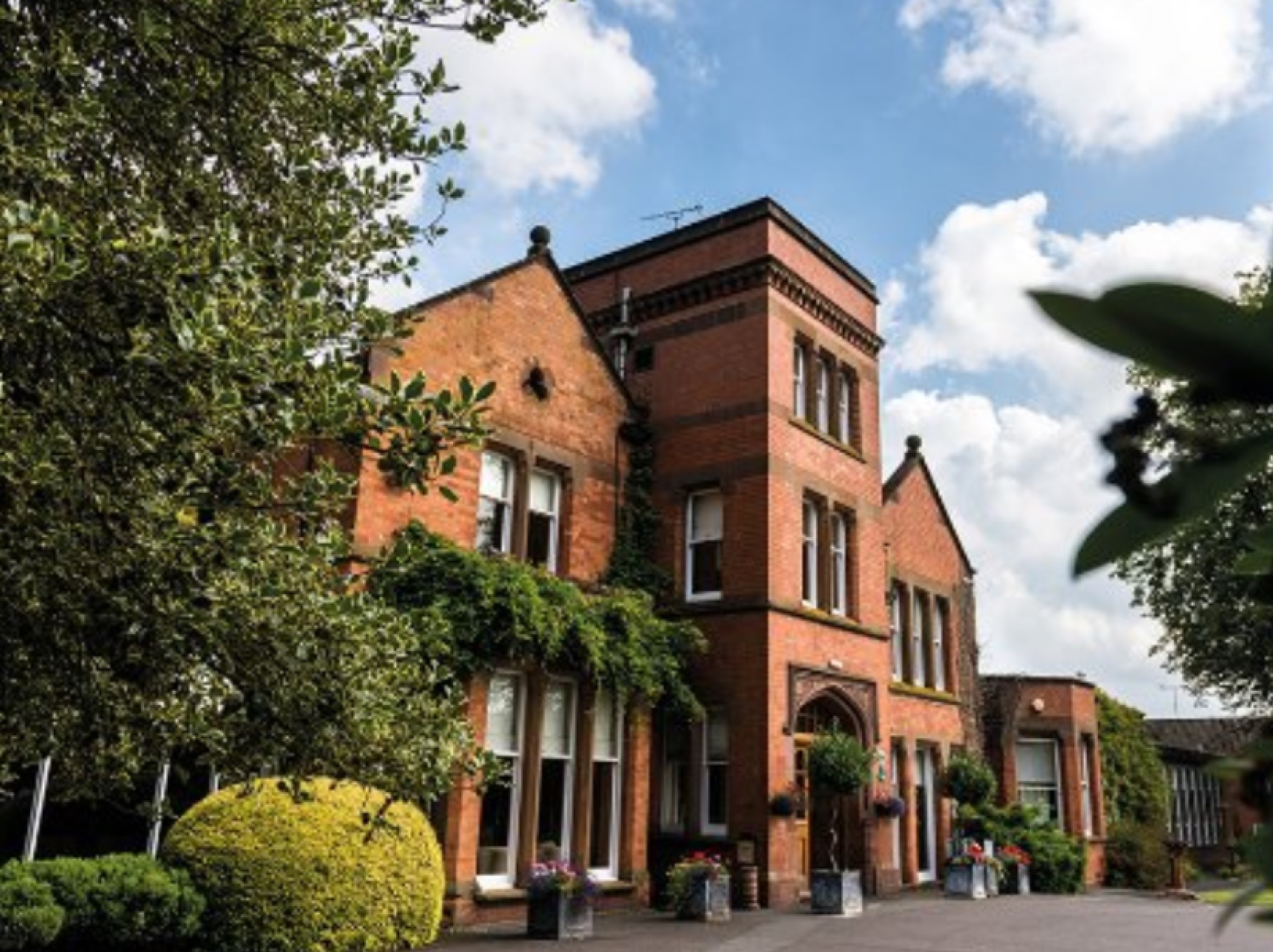
Woodside Hotel, Kenilworth

The Woodside Hotel is a building of historical significance in Kenilworth, Warwickshire, England. It was the residence of several notable people from about...

Kenilworth School and Sixth Form

Kenilworth School and Sixth Form, also known as Kenilworth School and Sports College, is a coeducational secondary school and sixth form based in Glasshouse...

Kenilworth

Kenilworth ( KEN-il-wərth) is a market town and civil parish in the Warwick District in Warwickshire, England, 6 miles (10 km) south-west of Coventry,...

Stoneleigh Abbey Gatehouse

Stoneleigh Abbey Gatehouse is the 14th century gatehouse to the medieval Stoneleigh Abbey which was established near Stoneleigh, Warwickshire in the 12th...

Kenilworth railway station

Kenilworth railway station serves the town of Kenilworth, Warwickshire, England; it is a stop on the Coventry to Leamington Line. The original Kenilworth...

Stoneleigh Abbey

Stoneleigh Abbey is an English country house and estate situated south of Coventry. Nearby is the village of Stoneleigh, Warwickshire. The Abbey itself...

Stoneleigh Park

Stoneleigh Park, known between 1963 and 2013 as the National Agricultural Centre, is a business park located south-west of the village of Stoneleigh, Warwickshire...

Priory Theatre

The Priory Theatre is an amateur theatre building and company located in Kenilworth, Warwickshire, England. There are 120 seats in a circle and stall layout...

Nearby Amenities

Located within 500m of 52.345352,-1.5522496
Bus Stop
Cornhill Grove
Bus: yes
Covered: no
Naptan AtcoCode: 4200F030700
Naptan Bearing: N
Naptan CommonName: Cornhill Grove
Naptan Crossing: Cornhill Grove
Naptan Indicator: Opp
Naptan NaptanCode: wardamap
Naptan Street: Dencer Crive
Naptan Verified: no
Passenger Information Display: no
Public Transport: platform
Source: naptan_import
Lat/Long: 52.3464417/-1.5559845
Bus Stop
Mayfield Drive
Bus: yes
Covered: no
Naptan AtcoCode: 4200F031200
Naptan Bearing: N
Naptan CommonName: Mayfield Drive
Naptan Indicator: Adj
Naptan NaptanCode: wardamdm
Naptan Street: Dencer Drive
Naptan Verified: no
Passenger Information Display: no
Public Transport: platform
Source: naptan_import
Lat/Long: 52.3418352/-1.5550912
Bus Stop
Leyes Lane
Bus: yes
Covered: no
Naptan AtcoCode: 4200F032100
Naptan Bearing: N
Naptan CommonName: Leyes Lane
Naptan Crossing: Leyes Lane
Naptan Indicator: Nr
Naptan NaptanCode: warapdwg
Naptan Street: Rawnsley Drive
Naptan Verified: no
Passenger Information Display: no
Public Transport: platform
Source: naptan_import
Lat/Long: 52.3479996/-1.5566589
Bus Stop
Rawnsley Drive
Bus: yes
Covered: no
Naptan AtcoCode: 4200F107501
Naptan Bearing: W
Naptan CommonName: Rawnsley Drive
Naptan Crossing: Rawnsley Drive
Naptan Indicator: Adj
Naptan NaptanCode: warapgmp
Naptan Street: Leyes Lane
Naptan Verified: no
Passenger Information Display: no
Public Transport: platform
Source: naptan_import
Lat/Long: 52.3471827/-1.55699
Bus Stop
Arlidge Crescent
Bus: yes
Covered: no
Naptan AtcoCode: 4200F129910
Naptan Bearing: N
Naptan CommonName: Arlidge Crescent
Naptan Crossing: Arlidge Crescent
Naptan Indicator: Opp
Naptan NaptanCode: warapgtm
Naptan Street: Dencer Drive
Naptan Verified: no
Passenger Information Display: no
Public Transport: platform
Source: naptan_import
Lat/Long: 52.3451731/-1.5557183
Turning Circle
Lat/Long: 52.3478587/-1.5578932
Turning Circle
Lat/Long: 52.3489564/-1.5564877
Turning Circle
Lat/Long: 52.3457122/-1.5568954
Turning Circle
Lat/Long: 52.3455156/-1.5575499
Turning Circle
Lat/Long: 52.3468127/-1.5574051
Turning Circle
Lat/Long: 52.3475281/-1.5554559
Post Box
Brand: Royal Mail
Brand Wikidata: Q638098
Brand Wikipedia: en:Royal Mail
Collection Times: Mo-Fr 16:00; Sa 08:30
Operator: Royal Mail
Operator Wikidata: Q638098
Post Box Type: pillar
Ref: CV8 465
Royal Cypher: EIIR
Royal Cypher Wikidata: Q33102113
Source: survey
Lat/Long: 52.3480805/-1.556532
Post Box
Brand: Royal Mail
Brand Wikidata: Q638098
Brand Wikipedia: en:Royal Mail
Collection Times: Mo-Fr 16:00; Sa 08:15
Operator: Royal Mail
Operator Wikidata: Q638098
Post Box Type: pillar
Ref: CV8 466
Royal Cypher: EIIR
Royal Cypher Wikidata: Q33102113
Source: survey
Lat/Long: 52.342122/-1.555162
Phone
Check Date: 2021-08-14
Emergency: phone
Lat/Long: 52.3444925/-1.5453739
Parking
Access: yes
Fee: no
Parking: layby
Lat/Long: 52.3445543/-1.5453525
Turning Circle
Lat/Long: 52.3436216/-1.5588424
Barrier: bollard
Lat/Long: 52.3439273/-1.5561641
Generator Method: photovoltaic
Generator Output Electricity: yes
Generator Source: solar
Generator Type: solar_photovoltaic_panel
Location: roof
Power: generator
Lat/Long: 52.3455337/-1.556561
Generator Method: photovoltaic
Generator Output Electricity: yes
Generator Source: solar
Generator Type: solar_photovoltaic_panel
Location: roof
Power: generator
Lat/Long: 52.3420172/-1.5563867
Generator Method: photovoltaic
Generator Output Electricity: yes
Generator Source: solar
Generator Type: solar_photovoltaic_panel
Location: roof
Power: generator
Lat/Long: 52.3463989/-1.5556034
Generator Method: photovoltaic
Generator Output Electricity: yes
Generator Source: solar
Generator Type: solar_photovoltaic_panel
Location: roof
Power: generator
Lat/Long: 52.3454714/-1.5569901
Generator Method: photovoltaic
Generator Output Electricity: yes
Generator Source: solar
Generator Type: solar_photovoltaic_panel
Location: roof
Power: generator
Lat/Long: 52.346371/-1.5569794
Generator Method: photovoltaic
Generator Output Electricity: yes
Generator Source: solar
Generator Type: solar_photovoltaic_panel
Location: roof
Power: generator
Lat/Long: 52.3464218/-1.5577358
Generator Method: photovoltaic
Generator Output Electricity: yes
Generator Source: solar
Generator Type: solar_photovoltaic_panel
Location: roof
Power: generator
Lat/Long: 52.3460974/-1.5578136
Material: wood
Operator: National Grid Electricity Distribution
Operator Wikidata: Q7988183
Power: pole
Lat/Long: 52.3484318/-1.5470599
Material: wood
Operator: National Grid Electricity Distribution
Operator Wikidata: Q7988183
Power: pole
Lat/Long: 52.3482267/-1.5479041
Material: wood
Operator: National Grid Electricity Distribution
Operator Wikidata: Q7988183
Power: pole
Lat/Long: 52.3481176/-1.5486523
Location Transition: yes
Material: wood
Operator: National Grid Electricity Distribution
Operator Wikidata: Q7988183
Power: pole
Lat/Long: 52.3480129/-1.5494475
Direction: forward
Maxspeed: 20 mph
Traffic Sign: maxspeed
Lat/Long: 52.3472996/-1.5565384
Direction: backward
Maxspeed: 20 mph
Traffic Sign: maxspeed
Lat/Long: 52.3491268/-1.5559574
Direction: forward
Maxspeed: 20 mph
Traffic Sign: maxspeed
Lat/Long: 52.3474384/-1.5549707
Direction: backward
Maxspeed: 20 mph
Traffic Sign: maxspeed
Lat/Long: 52.3460817/-1.5539684
Direction: backward
Maxspeed: 20 mph
Traffic Sign: maxspeed
Lat/Long: 52.3445731/-1.552783
Crossing
Crossing: unmarked
Crossing Island: yes
Crossing Markings: no
Traffic Calming: table
Lat/Long: 52.3485812/-1.5555235
Crossing
Crossing: traffic_signals
Lat/Long: 52.3465397/-1.5541695
Crossing
Crossing: traffic_signals
Lat/Long: 52.3476327/-1.5549093
Crossing
Crossing: uncontrolled
Crossing Markings: yes
Lat/Long: 52.3471182/-1.5537408
Entrance: yes
Lat/Long: 52.347354/-1.553017
Entrance: yes
Lat/Long: 52.3480306/-1.5537537
Leisure: playground
Lat/Long: 52.3453853/-1.5510124
Colour: red and white
Marker: aerial
Material: plastic
Utility: gas
Lat/Long: 52.3420288/-1.5474333
Generator Method: photovoltaic
Generator Output Electricity: yes
Generator Source: solar
Generator Type: solar_photovoltaic_panel
Location: roof
Power: generator
Lat/Long: 52.3475157/-1.5528165
Generator Method: photovoltaic
Generator Output Electricity: yes
Generator Source: solar
Generator Type: solar_photovoltaic_panel
Location: roof
Power: generator
Lat/Long: 52.3478131/-1.5529335
The data included in this document is from www.openstreetmap.org. The data is made available under ODbL.

Have you been to Victoria Spinney?

Leave your review of Victoria Spinney below (or comments, questions and feedback).