Icehouse Plantation

Wood, Forest in Hampshire New Forest

England

Icehouse Plantation

Footpath through Maize Crop at Lymore
Footpath through Maize Crop at Lymore Credit: Paul Collins

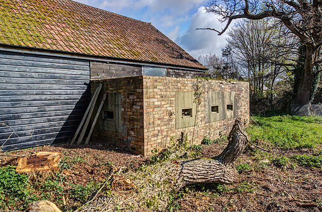
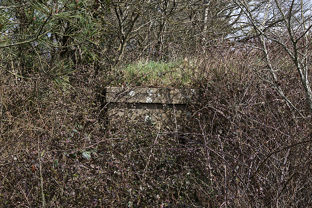
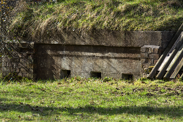
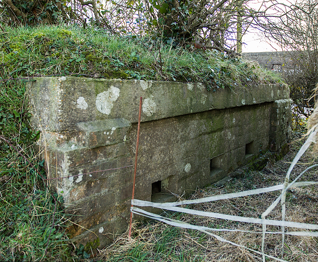
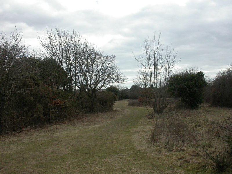
Icehouse Plantation is a historic woodland located in Hampshire, England. Situated in the heart of the New Forest National Park, this enchanting plantation covers an area of approximately 200 acres. The plantation gets its name from the icehouse that once stood on the grounds, which was used to store ice for the nearby manor house during the 18th and 19th centuries.

The woodland is predominantly composed of ancient oak and beech trees, creating a picturesque and tranquil atmosphere. It is home to a diverse range of flora and fauna, with bluebells, foxgloves, and primroses carpeting the forest floor in the spring months. Wildlife enthusiasts will be delighted to spot a variety of bird species, including woodpeckers and tawny owls.

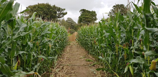
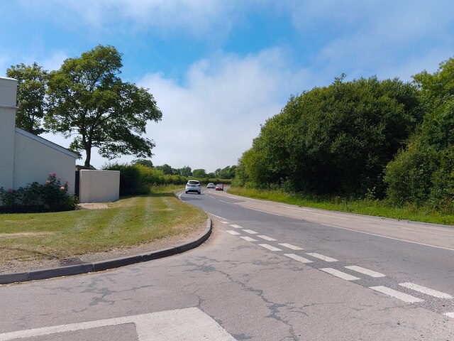
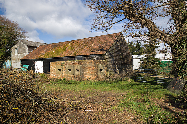
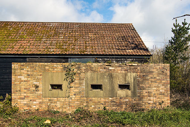
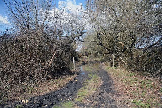
Icehouse Plantation offers an extensive network of well-maintained footpaths and trails, making it a popular destination for walkers and nature lovers. The paths wind through the woodland, providing stunning views of the surrounding countryside. Visitors can also explore the remnants of the old icehouse, which offers an intriguing glimpse into the past.

The plantation is managed by the Forestry Commission, ensuring the preservation of its natural beauty and heritage. It is open to the public year-round, with no admission fee. Icehouse Plantation is an idyllic escape from the hustle and bustle of everyday life, providing a serene environment for relaxation and exploration.

If you have any feedback on the listing, please let us know in the comments section below.

Icehouse Plantation Images

Images are sourced within 2km of 50.751248/-1.5940997 or Grid Reference SZ2894. Thanks to Geograph Open Source API. All images are credited.

Footpath through Maize Crop at Lymore
Christchurch Road (A337) Looking from Lymington Road (the B3058) at Christchurch Road (the A337).
Christchurch Road (A337)
Looking from Lymington Road (the B3058) at Christchurch Road (the A337).
WWII inland defences of SW Hampshire - defended building at Lymore (1) -
Pillbox (unclassified): DoB ID: S0007003

This rather unusual unclassified rectangular pillbox was a part of the network that extended inland from the coastal defences centred on Taddiford Gap to the south <a title="https://www.geograph.org.uk/photo/4878084" href="https://www.geograph.org.uk/photo/4878084">Link</a>. It has been disguised by being built into the adjacent barn, and can only be entered from within the barn itself.

<a href="https://www.geograph.org.uk/photo/4897271">SZ2993 : WWII inland defences of SW Hampshire - defended building at Lymore (2)</a>
WWII inland defences of SW Hampshire - defended building at Lymore (1)
- Pillbox (unclassified): DoB ID: S0007003 This rather unusual unclassified rectangular pillbox was a part of the network that extended inland from the coastal defences centred on Taddiford Gap to the south Link. It has been disguised by being built into the adjacent barn, and can only be entered from within the barn itself. SZ2993 : WWII inland defences of SW Hampshire - defended building at Lymore (2)
WWII inland defences of SW Hampshire - defended building at Lymore (2) -

Pillbox (unclassified): DoB ID: S0007003

The pillbox has pre-fabricated concrete embrasures, three on the front, including one double, and a single one at each end. All the sills are wood-lined, and retain their original iron shutters.

<a href="https://www.geograph.org.uk/photo/4897290">SZ2993 : WWII inland defences of SW Hampshire - defended building at Lymore (3)</a>
WWII inland defences of SW Hampshire - defended building at Lymore (2)
- Pillbox (unclassified): DoB ID: S0007003 The pillbox has pre-fabricated concrete embrasures, three on the front, including one double, and a single one at each end. All the sills are wood-lined, and retain their original iron shutters. SZ2993 : WWII inland defences of SW Hampshire - defended building at Lymore (3)
WWII inland defences of SW Hampshire - defended building at Lymore (3) -
Pillbox (unclassified): DoB ID: S0007003

The location of this south-facing pillbox is at a junction between the roads leading from the adjacent coastal resorts of Milford-on-Sea and Keyhaven.

<a href="https://www.geograph.org.uk/photo/4897296">SZ2993 : WWII inland defences of SW Hampshire - defended building at Lymore (4)</a>
WWII inland defences of SW Hampshire - defended building at Lymore (3)
- Pillbox (unclassified): DoB ID: S0007003 The location of this south-facing pillbox is at a junction between the roads leading from the adjacent coastal resorts of Milford-on-Sea and Keyhaven. SZ2993 : WWII inland defences of SW Hampshire - defended building at Lymore (4)
WWII inland defences of SW Hampshire - defended building at Lymore (4) -
Pillbox (unclassified): DoB ID: S0007003

<a href="https://www.geograph.org.uk/photo/4897317">SZ2993 : WWII inland defences of SW Hampshire - defended building at Lymore (5)</a>
WWII inland defences of SW Hampshire - defended building at Lymore (4)
WWII inland defences of SW Hampshire - defended building at Lymore (5) -
Pillbox (unclassified): DoB ID: S0007003

A close-up of one of the 5 embrasures showing the sill with its wood lining and internal iron shutter (with spy-hole) that's fitted to each loophole. Unfortunately the pillbox interior was not accessible, but is apparently in good condition with a number of artifacts still extant, such as a wooden gun support shelf, brick footrests, and a chain that opened an external steel shutter to an embrasure.

<a href="https://www.geograph.org.uk/photo/4897327">SZ2993 : WWII inland defences of SW Hampshire - defended building at Lymore (6)</a>
WWII inland defences of SW Hampshire - defended building at Lymore (5)
- Pillbox (unclassified): DoB ID: S0007003 A close-up of one of the 5 embrasures showing the sill with its wood lining and internal iron shutter (with spy-hole) that's fitted to each loophole. Unfortunately the pillbox interior was not accessible, but is apparently in good condition with a number of artifacts still extant, such as a wooden gun support shelf, brick footrests, and a chain that opened an external steel shutter to an embrasure. SZ2993 : WWII inland defences of SW Hampshire - defended building at Lymore (6)
WWII inland defences of SW Hampshire - defended building at Lymore (6) -
Pillbox (unclassified): DoB ID: S0007003

One of a number of surviving metal fixtures embedded along the edge of the roof for attaching camouflage netting.

<a href="https://www.geograph.org.uk/photo/4897344">SZ2993 : WWII inland defences of SW Hampshire - Everton pillbox (1)</a>
WWII inland defences of SW Hampshire - defended building at Lymore (6)
- Pillbox (unclassified): DoB ID: S0007003 One of a number of surviving metal fixtures embedded along the edge of the roof for attaching camouflage netting. SZ2993 : WWII inland defences of SW Hampshire - Everton pillbox (1)
WWII inland defences of SW Hampshire - Everton pillbox (1) -
Pillbox (unclassified): DoB ID: S0012876

I was assured of the existence of two pillboxes at this location, one a Home Guard section post (essentially hardened trench works), and a conventional pillbox. It was therefore disappointing to only find this specimen with just a corner peeping out at me from beneath the covering of brambles. I'm assuming this is the concrete faced pillbox listed on the Database of Britain Defence Archive. There was no sign of the section post.

<a href="https://www.geograph.org.uk/photo/4897370">SZ2993 : WWII inland defences of SW Hampshire - Everton pillbox (2)</a>
WWII inland defences of SW Hampshire - Everton pillbox (1)
- Pillbox (unclassified): DoB ID: S0012876 I was assured of the existence of two pillboxes at this location, one a Home Guard section post (essentially hardened trench works), and a conventional pillbox. It was therefore disappointing to only find this specimen with just a corner peeping out at me from beneath the covering of brambles. I'm assuming this is the concrete faced pillbox listed on the Database of Britain Defence Archive. There was no sign of the section post. SZ2993 : WWII inland defences of SW Hampshire - Everton pillbox (2)
WWII inland defences of SW Hampshire - Everton pillbox (2) -
Pillbox (unclassified): DoB ID: S0012876

Today this pillbox remains totally hidden in the vegetation to the right of the farm gate (and to the immediate left of the first chevron) on a bend in the main road between Lymington and Barton-on-Sea. Part of the network that extended inland from the coastal defences centred on Taddiford Gap to the south.

<a href="https://www.geograph.org.uk/photo/4897396">SZ2694 : WWII inland defences of SW Hampshire - Ashley pillbox (1)</a>
WWII inland defences of SW Hampshire - Everton pillbox (2)
- Pillbox (unclassified): DoB ID: S0012876 Today this pillbox remains totally hidden in the vegetation to the right of the farm gate (and to the immediate left of the first chevron) on a bend in the main road between Lymington and Barton-on-Sea. Part of the network that extended inland from the coastal defences centred on Taddiford Gap to the south. SZ2694 : WWII inland defences of SW Hampshire - Ashley pillbox (1)
Ford at Lymore This ford is found on Lymore Valley at Lymore.
Ford at Lymore
This ford is found on Lymore Valley at Lymore.
WWII inland defences of SW Hampshire - Section Post - east of Hordle (1) -
Section Post/unclassified pillbox: DoB ID: S0012874 

A small square brick and concrete section post or unclassified pillbox, with a style of construction that may be unique to this corner of Hampshire. There are at least 3 similar structures within a few miles of each other in the locality. For defence there are embrasures on two sides, a group of three at each end facing east and west respectively that covered the main Hordle to Lymington road in both directions.

<a href="https://www.geograph.org.uk/photo/5296800">SZ2795 : WWII inland defences of SW Hampshire - Section Post - east of Hordle (2)</a>
WWII inland defences of SW Hampshire - Section Post - east of Hordle (1)
- Section Post/unclassified pillbox: DoB ID: S0012874 A small square brick and concrete section post or unclassified pillbox, with a style of construction that may be unique to this corner of Hampshire. There are at least 3 similar structures within a few miles of each other in the locality. For defence there are embrasures on two sides, a group of three at each end facing east and west respectively that covered the main Hordle to Lymington road in both directions. SZ2795 : WWII inland defences of SW Hampshire - Section Post - east of Hordle (2)
WWII inland defences of SW Hampshire - Section Post - east of Hordle (2) -
Section Post/unclassified pillbox: DoB ID: S0012874

The entrance at the east end is currently sealed off with a covering of timber by the landowner, probably to protect the interior from flooding. The pillbox has been disguised by a covering of earth and turf on the roof.

<a href="https://www.geograph.org.uk/photo/5296801">SZ2795 : WWII inland defences of SW Hampshire - Section Post - east of Hordle (3)</a>
WWII inland defences of SW Hampshire - Section Post - east of Hordle (2)
- Section Post/unclassified pillbox: DoB ID: S0012874 The entrance at the east end is currently sealed off with a covering of timber by the landowner, probably to protect the interior from flooding. The pillbox has been disguised by a covering of earth and turf on the roof. SZ2795 : WWII inland defences of SW Hampshire - Section Post - east of Hordle (3)
WWII inland defences of SW Hampshire - Section Post - east of Hordle (3) -
Section Post/unclassified pillbox: DoB ID: S0012874

Three loopholes at one end face east along the Lymington to Hordle road.

<a href="https://www.geograph.org.uk/photo/5296802">SZ2795 : WWII inland defences of SW Hampshire - Section Post - east of Hordle (4)</a>
WWII inland defences of SW Hampshire - Section Post - east of Hordle (3)
- Section Post/unclassified pillbox: DoB ID: S0012874 Three loopholes at one end face east along the Lymington to Hordle road. SZ2795 : WWII inland defences of SW Hampshire - Section Post - east of Hordle (4)
WWII inland defences of SW Hampshire - Section Post - east of Hordle (4) -
Section Post/unclassified pillbox: DoB ID: S0012874

Three loopholes at the opposite end face west along the Lymington to Hordle road.

<a href="https://www.geograph.org.uk/photo/5299853">SZ2696 : WWII inland defences of SW Hampshire - Section Post - north of Hordle (1)</a>
WWII inland defences of SW Hampshire - Section Post - east of Hordle (4)
- Section Post/unclassified pillbox: DoB ID: S0012874 Three loopholes at the opposite end face west along the Lymington to Hordle road. SZ2696 : WWII inland defences of SW Hampshire - Section Post - north of Hordle (1)
Downton : The Old Barn A drive heading up to the house from Christchurch Road.
Downton : The Old Barn
A drive heading up to the house from Christchurch Road.
New Forest : Christchurch Road A337 A road heading through the New Forest District.
New Forest : Christchurch Road A337
A road heading through the New Forest District.
New Forest : Muddy Track A track heading off from Christchurch Road.
New Forest : Muddy Track
A track heading off from Christchurch Road.
Show me another place!

Icehouse Plantation is located at Grid Ref: SZ2894 (Lat: 50.751248, Lng: -1.5940997)

Administrative County: Hampshire

District: New Forest

Police Authority: Hampshire

What 3 Words

///issued.desktops.tiger. Near Milford on Sea, Hampshire

Related Wikis

Everton, Hampshire

Everton is a village in the civil parish of Hordle, 2+1⁄2 miles (4.0 km) west of Lymington, in the English county of Hampshire. == Overview == Everton...

Hordle

Hordle is a village and civil parish in the county of Hampshire, England. It is situated between the Solent coast and the New Forest, and is bordered by...

Downton, Hampshire

Downton is a hamlet in Hampshire, England, clustered around a crossroads on the A337 road (Lymington to New Milton) with a lane to the sea southwards whilst...

Pennington, Hampshire

Pennington is a ward (electoral and ecclesiastical) in the New Forest district of Hampshire, England, which is defined based on the boundaries of the earlier...

Milford on Sea LNR

Milford on Sea LNR is a 20.6-hectare (51-acre) local nature reserve in Milford on Sea in Hampshire. It is owned and managed by Milford On Sea Parish Council...

Priestlands School

Priestlands School is a Mixed-sex education secondary school located in Pennington, Hampshire in southern England. The school serves an area that includes...

Milford on Sea

Milford on Sea, often hyphenated, is a large coastal village and civil parish in the New Forest district, on the Hampshire coast, England. The parish had...

Solent Way

The Solent Way is a 60-mile (97 km) long-distance footpath in Hampshire, southern England. With the exception of a few inland diversions, the path follows...

Nearby Amenities

Located within 500m of 50.751248,-1.5940997
Everton Pavilion
Description: Sports pavilion and community hall for the recreation ground in Everton Hampshire
Note: Sports Pavilion and Community Hall
Lat/Long: 50.7479373/-1.5945308
Generator Method: photovoltaic
Generator Output Electricity: yes
Generator Source: solar
Generator Type: solar_photovoltaic_panel
Location: roof
Power: generator
Lat/Long: 50.7489762/-1.5899974
Generator Method: photovoltaic
Generator Output Electricity: yes
Generator Source: solar
Generator Type: solar_photovoltaic_panel
Location: roof
Power: generator
Lat/Long: 50.7486096/-1.5898499
Generator Method: photovoltaic
Generator Output Electricity: yes
Generator Source: solar
Generator Type: solar_photovoltaic_panel
Location: roof
Power: generator
Lat/Long: 50.7485995/-1.5899451
Generator Method: photovoltaic
Generator Output Electricity: yes
Generator Source: solar
Generator Type: solar_photovoltaic_panel
Location: roof
Power: generator
Lat/Long: 50.748882/-1.5922062
Generator Method: photovoltaic
Generator Output Electricity: yes
Generator Source: solar
Generator Type: solar_photovoltaic_panel
Location: roof
Power: generator
Lat/Long: 50.7489185/-1.5920439
Generator Method: photovoltaic
Generator Output Electricity: yes
Generator Source: solar
Generator Type: solar_photovoltaic_panel
Location: roof
Power: generator
Lat/Long: 50.7489109/-1.592107
Generator Method: photovoltaic
Generator Output Electricity: yes
Generator Source: solar
Generator Type: solar_photovoltaic_panel
Location: roof
Power: generator
Lat/Long: 50.7488608/-1.5922679
Generator Method: photovoltaic
Generator Output Electricity: yes
Generator Source: solar
Generator Type: solar_photovoltaic_panel
Location: roof
Power: generator
Lat/Long: 50.7488617/-1.5923135
Generator Method: photovoltaic
Generator Output Electricity: yes
Generator Source: solar
Generator Type: solar_photovoltaic_panel
Location: roof
Power: generator
Lat/Long: 50.7487844/-1.5926877
Generator Method: photovoltaic
Generator Output Electricity: yes
Generator Source: solar
Generator Type: solar_photovoltaic_panel
Location: roof
Power: generator
Lat/Long: 50.7489983/-1.5928245
Generator Method: photovoltaic
Generator Output Electricity: yes
Generator Source: solar
Generator Type: solar_photovoltaic_panel
Location: roof
Power: generator
Lat/Long: 50.7470686/-1.5962255
Generator Method: photovoltaic
Generator Output Electricity: yes
Generator Source: solar
Generator Type: solar_photovoltaic_panel
Location: roof
Power: generator
Lat/Long: 50.7475778/-1.591647
The data included in this document is from www.openstreetmap.org. The data is made available under ODbL.

Have you been to Icehouse Plantation?

Leave your review of Icehouse Plantation below (or comments, questions and feedback).