Barrows Copse

Wood, Forest in Hampshire New Forest

England

Barrows Copse

Ford at Hordle This ford is found on Agars Lane at Hordle.
Ford at Hordle Credit: John Walton

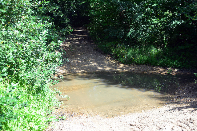
Barrows Copse is a picturesque woodland located in Hampshire, England. Covering an area of approximately 50 hectares, it is a popular destination for nature enthusiasts and outdoor lovers. The copse is nestled within the beautiful Hampshire countryside, offering visitors a tranquil retreat away from the hustle and bustle of urban life.

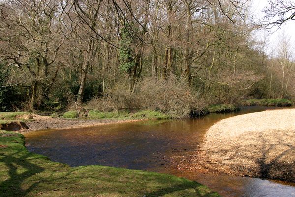
The woodland is predominantly made up of broadleaf trees, including oak, beech, and ash, creating a diverse and vibrant ecosystem. Walking through the copse, visitors can marvel at the towering trees, their branches forming a dense canopy that filters sunlight and casts a peaceful shade on the forest floor. The woodland is also home to a variety of wildlife, such as deer, squirrels, and a wide range of bird species, making it a haven for nature photographers and birdwatchers.

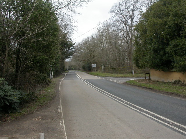
Barrows Copse features well-maintained walking trails that wind through the woodland, allowing visitors to explore its beauty at their own pace. The trails vary in length and difficulty, catering to both casual strollers and avid hikers. Along the paths, there are informative signs highlighting the flora and fauna found in the copse, providing educational opportunities for nature enthusiasts of all ages.

The copse is open to the public year-round, with no admission fee. It offers ample parking facilities and picnic areas, making it an ideal spot for family outings and group activities. Overall, Barrows Copse is a cherished natural gem in Hampshire, offering visitors a chance to connect with nature and immerse themselves in the beauty of the countryside.

If you have any feedback on the listing, please let us know in the comments section below.

Barrows Copse Images

Images are sourced within 2km of 50.765731/-1.6006247 or Grid Reference SZ2896. Thanks to Geograph Open Source API. All images are credited.

Ford at Hordle This ford is found on Agars Lane at Hordle.
Ford at Hordle
This ford is found on Agars Lane at Hordle.
WWII inland defences of SW Hampshire - Section Post - east of Hordle (1) -
Section Post/unclassified pillbox: DoB ID: S0012874 

A small square brick and concrete section post or unclassified pillbox, with a style of construction that may be unique to this corner of Hampshire. There are at least 3 similar structures within a few miles of each other in the locality. For defence there are embrasures on two sides, a group of three at each end facing east and west respectively that covered the main Hordle to Lymington road in both directions.

<a href="https://www.geograph.org.uk/photo/5296800">SZ2795 : WWII inland defences of SW Hampshire - Section Post - east of Hordle (2)</a>
WWII inland defences of SW Hampshire - Section Post - east of Hordle (1)
- Section Post/unclassified pillbox: DoB ID: S0012874 A small square brick and concrete section post or unclassified pillbox, with a style of construction that may be unique to this corner of Hampshire. There are at least 3 similar structures within a few miles of each other in the locality. For defence there are embrasures on two sides, a group of three at each end facing east and west respectively that covered the main Hordle to Lymington road in both directions. SZ2795 : WWII inland defences of SW Hampshire - Section Post - east of Hordle (2)
WWII inland defences of SW Hampshire - Section Post - east of Hordle (2) -
Section Post/unclassified pillbox: DoB ID: S0012874

The entrance at the east end is currently sealed off with a covering of timber by the landowner, probably to protect the interior from flooding. The pillbox has been disguised by a covering of earth and turf on the roof.

<a href="https://www.geograph.org.uk/photo/5296801">SZ2795 : WWII inland defences of SW Hampshire - Section Post - east of Hordle (3)</a>
WWII inland defences of SW Hampshire - Section Post - east of Hordle (2)
- Section Post/unclassified pillbox: DoB ID: S0012874 The entrance at the east end is currently sealed off with a covering of timber by the landowner, probably to protect the interior from flooding. The pillbox has been disguised by a covering of earth and turf on the roof. SZ2795 : WWII inland defences of SW Hampshire - Section Post - east of Hordle (3)
WWII inland defences of SW Hampshire - Section Post - east of Hordle (3) -
Section Post/unclassified pillbox: DoB ID: S0012874

Three loopholes at one end face east along the Lymington to Hordle road.

<a href="https://www.geograph.org.uk/photo/5296802">SZ2795 : WWII inland defences of SW Hampshire - Section Post - east of Hordle (4)</a>
WWII inland defences of SW Hampshire - Section Post - east of Hordle (3)
- Section Post/unclassified pillbox: DoB ID: S0012874 Three loopholes at one end face east along the Lymington to Hordle road. SZ2795 : WWII inland defences of SW Hampshire - Section Post - east of Hordle (4)
WWII inland defences of SW Hampshire - Section Post - east of Hordle (4) -
Section Post/unclassified pillbox: DoB ID: S0012874

Three loopholes at the opposite end face west along the Lymington to Hordle road.

<a href="https://www.geograph.org.uk/photo/5299853">SZ2696 : WWII inland defences of SW Hampshire - Section Post - north of Hordle (1)</a>
WWII inland defences of SW Hampshire - Section Post - east of Hordle (4)
- Section Post/unclassified pillbox: DoB ID: S0012874 Three loopholes at the opposite end face west along the Lymington to Hordle road. SZ2696 : WWII inland defences of SW Hampshire - Section Post - north of Hordle (1)
WWII inland defences of SW Hampshire - Section Post - north of Hordle (1) -
Section Post: DoB ID: S0012873

In an area that has quite a number of unique defensive structures, this one surely must rank among them as perhaps one of the more unusual. It's certainly a section post, made of reinforced concrete and brick, and has room for a 'section' of at least 8 - 10 men,  although this is not apparent in this view of the south side. It was built to cover the former Southern Railway line from London to the South, whose modern equivalent is just yards away to the right beyond the green fencing.

<a href="https://www.geograph.org.uk/photo/5299855">SZ2696 : WWII inland defences of SW Hampshire - Section Post - north of Hordle (2)</a>
WWII inland defences of SW Hampshire - Section Post - north of Hordle (1)
- Section Post: DoB ID: S0012873 In an area that has quite a number of unique defensive structures, this one surely must rank among them as perhaps one of the more unusual. It's certainly a section post, made of reinforced concrete and brick, and has room for a 'section' of at least 8 - 10 men, although this is not apparent in this view of the south side. It was built to cover the former Southern Railway line from London to the South, whose modern equivalent is just yards away to the right beyond the green fencing. SZ2696 : WWII inland defences of SW Hampshire - Section Post - north of Hordle (2)
WWII inland defences of SW Hampshire - Section Post - north of Hordle (2) -
Section Post: DoB ID: S0012873

The building can best be described as three narrow rectangular blocks joined together to form an irregular open square of three sides facing roughly north, south and east respectively. That description of it is apparent in this view of the structure which has outward facing loopholes or firing positions on all three main sides, in addition to a single one at each of the two west facing ends (13 in total). The length of the south block on the right is shorter than the north block on the left, and is slightly offset by less than 90 degrees to achieve a better angle of fire for its three embrasures on the south side. The longer north block has four embrasures, as has the east block whose lengths are probably equal to each other.

Modern wooden fencing now surrounds the steps leading down to the entrance in the north block, erected for H & S reasons by the owner of the holiday caravan park on whose site the section post is on.

<a href="https://www.geograph.org.uk/photo/5299861">SZ2696 : WWII inland defences of SW Hampshire - Section Post - north of Hordle (3)</a>
WWII inland defences of SW Hampshire - Section Post - north of Hordle (2)
- Section Post: DoB ID: S0012873 The building can best be described as three narrow rectangular blocks joined together to form an irregular open square of three sides facing roughly north, south and east respectively. That description of it is apparent in this view of the structure which has outward facing loopholes or firing positions on all three main sides, in addition to a single one at each of the two west facing ends (13 in total). The length of the south block on the right is shorter than the north block on the left, and is slightly offset by less than 90 degrees to achieve a better angle of fire for its three embrasures on the south side. The longer north block has four embrasures, as has the east block whose lengths are probably equal to each other. Modern wooden fencing now surrounds the steps leading down to the entrance in the north block, erected for H & S reasons by the owner of the holiday caravan park on whose site the section post is on. SZ2696 : WWII inland defences of SW Hampshire - Section Post - north of Hordle (3)
WWII inland defences of SW Hampshire - Section Post - north of Hordle (3) -
Section Post: DoB ID: S0012873

Some idea of the irregular open square design of the building is apparent in this shot of the concrete roof of the structure from the south east corner. Its plan view has also been described as a squared 'C'.

<a href="https://www.geograph.org.uk/photo/5299863">SZ2696 : WWII inland defences of SW Hampshire - Section Post - north of Hordle (4)</a>
WWII inland defences of SW Hampshire - Section Post - north of Hordle (3)
- Section Post: DoB ID: S0012873 Some idea of the irregular open square design of the building is apparent in this shot of the concrete roof of the structure from the south east corner. Its plan view has also been described as a squared 'C'. SZ2696 : WWII inland defences of SW Hampshire - Section Post - north of Hordle (4)
WWII inland defences of SW Hampshire - Section Post - north of Hordle (4) -
Section Post: DoB ID: S0012873

The south east corner showing the three embrasures on the south face, and the four on the east.

<a href="https://www.geograph.org.uk/photo/5299865">SZ2696 : WWII inland defences of SW Hampshire - Section Post - north of Hordle (5)</a>
WWII inland defences of SW Hampshire - Section Post - north of Hordle (4)
- Section Post: DoB ID: S0012873 The south east corner showing the three embrasures on the south face, and the four on the east. SZ2696 : WWII inland defences of SW Hampshire - Section Post - north of Hordle (5)
WWII inland defences of SW Hampshire - Section Post - north of Hordle (5) -
Section Post: DoB ID: S0012873

View of the east block with its four embrasures facing the railway line.

<a href="https://www.geograph.org.uk/photo/5299868">SZ2696 : WWII inland defences of SW Hampshire - Section Post - north of Hordle (6)</a>
WWII inland defences of SW Hampshire - Section Post - north of Hordle (5)
- Section Post: DoB ID: S0012873 View of the east block with its four embrasures facing the railway line. SZ2696 : WWII inland defences of SW Hampshire - Section Post - north of Hordle (6)
WWII inland defences of SW Hampshire - Section Post - north of Hordle (6) -
Section Post: DoB ID: S0012873

View of the blast wall protected entrance at the west end of the north block that also show the steps leading down to it. The modern wooden fencing and the boarded up opening of the entrance doorway are there as a H & S measure  by the owner, to prevent animals and inquisitive children on holiday at the caravan park from gaining access.

<a href="https://www.geograph.org.uk/photo/5299877">SZ2696 : WWII inland defences of SW Hampshire - Section Post - north of Hordle (7)</a>
WWII inland defences of SW Hampshire - Section Post - north of Hordle (6)
- Section Post: DoB ID: S0012873 View of the blast wall protected entrance at the west end of the north block that also show the steps leading down to it. The modern wooden fencing and the boarded up opening of the entrance doorway are there as a H & S measure by the owner, to prevent animals and inquisitive children on holiday at the caravan park from gaining access. SZ2696 : WWII inland defences of SW Hampshire - Section Post - north of Hordle (7)
WWII inland defences of SW Hampshire - Section Post - north of Hordle (7) -
Section Post: DoB ID: S0012873

The view north of both the north and south blocks. Both are joined at their east ends by the east block which is effectively an open ended corridor linking them together.

<a href="https://www.geograph.org.uk/photo/5299880">SZ2696 : WWII inland defences of SW Hampshire - Section Post - north of Hordle (8)</a>
WWII inland defences of SW Hampshire - Section Post - north of Hordle (7)
- Section Post: DoB ID: S0012873 The view north of both the north and south blocks. Both are joined at their east ends by the east block which is effectively an open ended corridor linking them together. SZ2696 : WWII inland defences of SW Hampshire - Section Post - north of Hordle (8)
WWII inland defences of SW Hampshire - Section Post - north of Hordle (8) -
Section Post: DoB ID: S0012873

Interior view from the west end of the entire length of the south block with its three embrasures that provided enfilade fire south along the railway. Points to note are the rather decorative arched blast wall at the far end with its opening leading off to the left into the south end of the east block. Also the built-in step or footrest for the gunners and the weapon support shelf above it that doubled up as reinforcement for the structure. One can imagine the two legs of a bipod mount at each embrasure being supported on the shelf.

<a href="https://www.geograph.org.uk/photo/5299898">SZ2696 : WWII inland defences of SW Hampshire - Section Post - north of Hordle (9)</a>
WWII inland defences of SW Hampshire - Section Post - north of Hordle (8)
- Section Post: DoB ID: S0012873 Interior view from the west end of the entire length of the south block with its three embrasures that provided enfilade fire south along the railway. Points to note are the rather decorative arched blast wall at the far end with its opening leading off to the left into the south end of the east block. Also the built-in step or footrest for the gunners and the weapon support shelf above it that doubled up as reinforcement for the structure. One can imagine the two legs of a bipod mount at each embrasure being supported on the shelf. SZ2696 : WWII inland defences of SW Hampshire - Section Post - north of Hordle (9)
WWII inland defences of SW Hampshire - Section Post - north of Hordle (9) -
Section Post: DoB ID: S0012873

A similar view to the previous one, but of the interior of the northern block. At the far end is the opening in the arched blast wall that leads off to the right into the  north end of the east block. It has four embrasures that face north along the railway, and a similar arrangement below them of footrests and weapon support shelving. Daylight from the entrance doorway can be seen on the right.

<a href="https://www.geograph.org.uk/photo/5300416">SZ2696 : WWII inland defences of SW Hampshire - Section Post - north of Hordle (10)</a>
WWII inland defences of SW Hampshire - Section Post - north of Hordle (9)
- Section Post: DoB ID: S0012873 A similar view to the previous one, but of the interior of the northern block. At the far end is the opening in the arched blast wall that leads off to the right into the north end of the east block. It has four embrasures that face north along the railway, and a similar arrangement below them of footrests and weapon support shelving. Daylight from the entrance doorway can be seen on the right. SZ2696 : WWII inland defences of SW Hampshire - Section Post - north of Hordle (10)
WWII inland defences of SW Hampshire - Section Post - north of Hordle (10) -
Section Post: DoB ID: S0012873

This opening in the arched blast wall is the point in the south block where it joins the south end of the east. A similar arrangement exists at the other end of the east block where it joins with the east end of the north. The east block whilst still a defensive position, effectively acts as an interlinking corridor between both the north and south blocks. The quality of the brickwork here is quite outstanding for such a building.

The section post is on private land, the site of a holiday caravan park. With thanks to Shirley Davis at 'Miranda' for granting permission to access the site. 

START: <a href="https://www.geograph.org.uk/photo/4897262">SZ2993 : WWII inland defences of SW Hampshire - defended building at Lymore (1)</a>
WWII inland defences of SW Hampshire - Section Post - north of Hordle (10)
- Section Post: DoB ID: S0012873 This opening in the arched blast wall is the point in the south block where it joins the south end of the east. A similar arrangement exists at the other end of the east block where it joins with the east end of the north. The east block whilst still a defensive position, effectively acts as an interlinking corridor between both the north and south blocks. The quality of the brickwork here is quite outstanding for such a building. The section post is on private land, the site of a holiday caravan park. With thanks to Shirley Davis at 'Miranda' for granting permission to access the site. START: SZ2993 : WWII inland defences of SW Hampshire - defended building at Lymore (1)
Footpath through field gate
Footpath on track south from Batchley Farm
Footpath through woods from Everton towards Batchley Farm
Show me another place!

Barrows Copse is located at Grid Ref: SZ2896 (Lat: 50.765731, Lng: -1.6006247)

Administrative County: Hampshire

District: New Forest

Police Authority: Hampshire

What 3 Words

///plunger.titles.chambers. Near Sway, Hampshire

Nearby Locations

Barrows Copse

Related Wikis

Hordle

Hordle is a village and civil parish in the county of Hampshire, England. It is situated between the Solent coast and the New Forest, and is bordered by...

Sway, Hampshire

Sway is a village and civil parish in Hampshire in the New Forest national park in England. The civil parish was formed in 1879, when lands were taken...

Sway railway station

Sway railway station serves the village of Sway in Hampshire, England. It is located on the South West Main Line from London Waterloo to Weymouth. It is...

Everton, Hampshire

Everton is a village in the civil parish of Hordle, 2+1⁄2 miles (4.0 km) west of Lymington, in the English county of Hampshire. == Overview == Everton...

Battramsley

Battramsley is a hamlet in the civil parish of Boldre, in the New Forest in Hampshire, England. == Overview == Battramsley is a hamlet located just west...

Ashley, New Forest

Ashley is a village located in the southwest of Hampshire, England. It lies on the eastern outskirts of New Milton in the New Forest district, and is two...

Avon Water, Hampshire

Avon Water is a small river draining some of the southwest of the New Forest in Hampshire to The Solent. West of the upper part of its archetypally dendritic...

Shirley Holms Halt railway station

Shirley Holms Halt was a railway halt in the New Forest district of Hampshire. Opened in 1860 it was closed in 1888 with opening of Sway on the South West...

Nearby Amenities

Located within 500m of 50.765731,-1.6006247
Bus Stop
Barrows Lane
Bus: yes
Naptan AtcoCode: 1900HA080721
Naptan Bearing: W
Naptan CommonName: Barrows Lane
Naptan NaptanCode: hamagmwm
Naptan Street: Silver Street
Naptan Verified: no
Public Transport: platform
Source: naptan_import
Lat/Long: 50.7629595/-1.603525
Bus Stop
Barrows Lane
Bus: yes
Naptan AtcoCode: 1900HA080722
Naptan Bearing: E
Naptan CommonName: Barrows Lane
Naptan NaptanCode: hamagmwp
Naptan Street: Silver Street
Naptan Verified: no
Public Transport: platform
Source: naptan_import
Lat/Long: 50.7630135/-1.6035245
Bus Stop
Malwood Nursery
Bus: yes
Naptan AtcoCode: 1900HA080723
Naptan Bearing: W
Naptan CommonName: Malwood Nursery
Naptan NaptanCode: hamagpgm
Naptan Street: Silver Street
Naptan Verified: no
Public Transport: platform
Source: naptan_import
Lat/Long: 50.7629545/-1.5994272
Bus Stop
Malwood Nursery
Bus: yes
Naptan AtcoCode: 1900HA080724
Naptan Bearing: E
Naptan CommonName: Malwood Nursery
Naptan NaptanCode: hamagpgp
Naptan Street: Silver Street
Naptan Verified: no
Public Transport: platform
Source: naptan_import
Lat/Long: 50.7629994/-1.5993985
Post Box
Operator: Royal Mail
Operator Wikidata: Q638098
Ref: SO41 104
Lat/Long: 50.7628815/-1.6048006
Lightfoot's Farm Touring Caravan Park
Tourism: caravan_site
Lat/Long: 50.762096/-1.5996266
Homefield
Tourism: caravan_site
Lat/Long: 50.7621469/-1.5971483
Power: pole
Lat/Long: 50.7675268/-1.5941092
Power: pole
Lat/Long: 50.768034/-1.5956059
Power: pole
Lat/Long: 50.7689823/-1.5982318
Power: pole
Lat/Long: 50.769788/-1.6013432
Barrier: yes
Lat/Long: 50.7621802/-1.5977142
The data included in this document is from www.openstreetmap.org. The data is made available under ODbL.

Have you been to Barrows Copse?

Leave your review of Barrows Copse below (or comments, questions and feedback).