Foxley Wood

Wood, Forest in Derbyshire South Derbyshire

England

Foxley Wood

Field of Oilseed Rape near Linton Crop field bordering onto the village of Linton. This picture is taken from a public footpath west of the village on a bright and breezy afternoon in early May.
Field of Oilseed Rape near Linton Credit: Jonathan Clitheroe

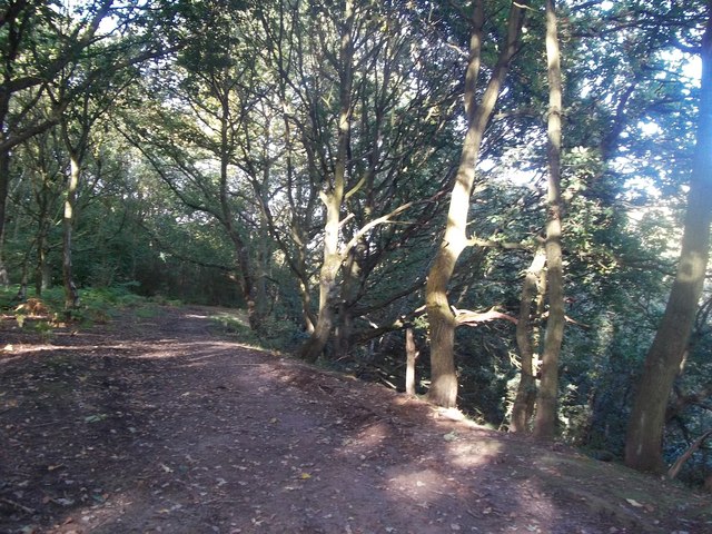
Foxley Wood is a picturesque woodland located in the county of Derbyshire, England. Spanning an area of approximately 25 hectares, it is known for its diverse range of flora and fauna, making it a popular destination for nature enthusiasts and hikers alike.

The woodland is predominantly made up of deciduous trees, with oak, birch, and beech being the most prominent species. These towering trees provide a dense canopy, casting dappled sunlight onto the forest floor, creating a tranquil and serene atmosphere. Springtime at Foxley Wood is particularly enchanting, as bluebells carpet the ground, transforming the woodland into a sea of vibrant blue hues.

Wildlife thrives in this natural habitat, and visitors may catch glimpses of various bird species, including woodpeckers, owls, and warblers. The wood is also home to a diverse range of mammals, such as badgers, foxes, and deer, which can often be spotted roaming through the undergrowth.

For those looking to explore the area, Foxley Wood offers several well-maintained paths and trails, allowing visitors to immerse themselves in the beauty of nature. The wood is also equipped with picnic areas, making it an ideal spot for a leisurely lunch amidst the tranquil surroundings.

Foxley Wood is cared for by the Woodland Trust, a leading conservation charity in the United Kingdom. The trust actively manages the woodland, ensuring its preservation for future generations to enjoy. It also organizes various events and activities throughout the year, providing opportunities for individuals to learn more about the importance of woodland conservation.

Overall, Foxley Wood is a natural haven, offering a peaceful retreat from the hustle and bustle of everyday life, and providing a valuable habitat for a wide range of plant and animal species.

If you have any feedback on the listing, please let us know in the comments section below.

Foxley Wood Images

Images are sourced within 2km of 52.748525/-1.5874185 or Grid Reference SK2716. Thanks to Geograph Open Source API. All images are credited.

Field of Oilseed Rape near Linton Crop field bordering onto the village of Linton. This picture is taken from a public footpath west of the village on a bright and breezy afternoon in early May.
Field of Oilseed Rape near Linton
Crop field bordering onto the village of Linton. This picture is taken from a public footpath west of the village on a bright and breezy afternoon in early May.
High Street in Linton High street viewed here on a bright and breezy afternoon in early May. Linton is mentioned in Domesday Book as being under the ownership of Henry de Ferrers.
High Street in Linton
High street viewed here on a bright and breezy afternoon in early May. Linton is mentioned in Domesday Book as being under the ownership of Henry de Ferrers.
Footpath Skirting Potter's Wood Public footpath heading in the direction of Grangewood Hall.
Footpath Skirting Potter's Wood
Public footpath heading in the direction of Grangewood Hall.
Northern Edge of Potter's Wood Gate and footpath leading out of Potter's Wood, close to Park Farm.
Northern Edge of Potter's Wood
Gate and footpath leading out of Potter's Wood, close to Park Farm.
Triangulation Pillar in Potter's Wood Trig Pillar near Park Farm, situated at 125 metres above sea level. There are excellent views over the Mease valley to the south from this position.
Triangulation Pillar in Potter's Wood
Trig Pillar near Park Farm, situated at 125 metres above sea level. There are excellent views over the Mease valley to the south from this position.
The Scotts bridge The Scotts as it passes over the disused railway line near to Castle Gresley.
The Scotts bridge
The Scotts as it passes over the disused railway line near to Castle Gresley.
Paddocks, Castle Gresley Paddocks off Mount Road near the railway line, Castle Gresley.
Paddocks, Castle Gresley
Paddocks off Mount Road near the railway line, Castle Gresley.
Linton Village sign Linton Village sign on approaching Linton Heath from the roundabout.
Linton Village sign
Linton Village sign on approaching Linton Heath from the roundabout.
Track near Swainspark A fairly freshly-laid path running alongside the Leicester railway line.
Track near Swainspark
A fairly freshly-laid path running alongside the Leicester railway line.
Woodland Path above Gresley Railway Tunnel Swainspark Wood, also known as Tunnel Woods in this area.
Woodland Path above Gresley Railway Tunnel
Swainspark Wood, also known as Tunnel Woods in this area.
RSA Fellows Wood near Castle Gresley An area of new woodland adjoining a footpath next to the Gresley Railway Tunnel.
RSA Fellows Wood near Castle Gresley
An area of new woodland adjoining a footpath next to the Gresley Railway Tunnel.
Castle Road in Castle Gresley
Westminster Drive
Westminster Drive
Salford Way
Salford Way
Salford Way
Salford Way
Site of Gresley station, 1995 View westward, towards Burton-on-Trent: ex-Midland Leicester - Burton line. The station, - mainly located off to the right, was closed 7/9/64 when the Leicester - Burton passenger service ceased.  However, the line has remained open for freight and may yet have a passenger service on the 'Ivanhoe Line'.
Site of Gresley station, 1995
View westward, towards Burton-on-Trent: ex-Midland Leicester - Burton line. The station, - mainly located off to the right, was closed 7/9/64 when the Leicester - Burton passenger service ceased. However, the line has remained open for freight and may yet have a passenger service on the 'Ivanhoe Line'.
Path to Swainspark
Path to Swainspark
Railway line to Burton
Show me another place!

Foxley Wood is located at Grid Ref: SK2716 (Lat: 52.748525, Lng: -1.5874185)

Administrative County: Derbyshire

District: South Derbyshire

Police Authority: Derbyshire

What 3 Words

///reference.mimes.generals. Near Swadlincote, Derbyshire

Nearby Locations

Foxley Wood Linton Linton

Related Wikis

Linton, Derbyshire

Linton is a settlement and civil parish in South Derbyshire, England, 5 miles south east of Burton-on-Trent. The population of the civil parish taken at...

Gresley railway station

Gresley railway station was a railway station at Castle Gresley, Derbyshire on the Leicester to Burton upon Trent Line. == History == The line was built...
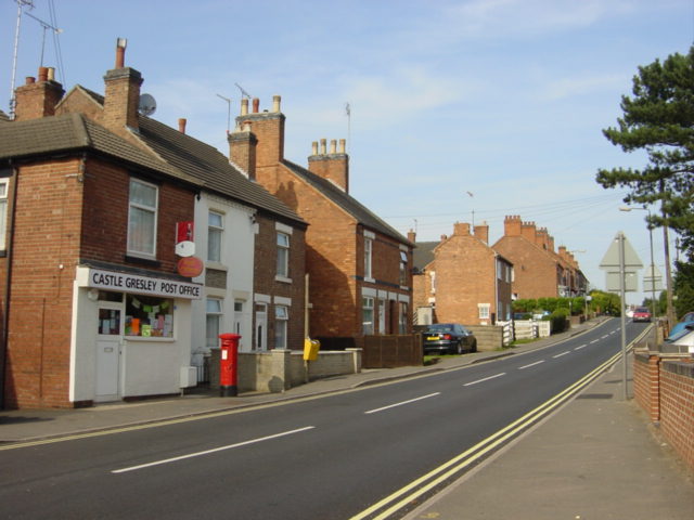
Castle Gresley

Castle Gresley is a village and civil parish about 1.75 miles (2.82 km) southwest of the centre of Swadlincote in South Derbyshire, England. The population...

St George and St Mary's Church, Church Gresley

St George and St Mary's Church, Church Gresley is a Grade II* listed parish church in the Church of England in Church Gresley, Derbyshire. == History... ==

Gresley Priory

Gresley Priory was a monastery of Augustinian Canons regular in Church Gresley, Derbyshire, England, founded in the 12th century. Following the Dissolution...

Church Gresley

Church Gresley is a large suburban village and former civil parish in the South Derbyshire district of Derbyshire, England. The village is situated between...

Overseal

Overseal is a village and civil parish in South Derbyshire district of Derbyshire, England. It is 3 miles (4.8 km) south of Swadlincote, 5 miles (8.0 km...

Gresley Rovers F.C.

Gresley Rovers Football Club is an English football club from Church Gresley, South Derbyshire. Gresley is a member of the Northern Premier League Division...

Related Videos

Hanging Toiletry Bag - Panther Travel

Hanging Toiletry Bag Perfect Travel bag for all your cosmetics and Toiletries.

Family Camping

In this video I take my mum and dog Bella camping to Conkers Camping and Caravanning Club. To be fair my mum had seen ...

Nearby Amenities

Located within 500m of 52.748525,-1.5874185
Linton
Is In Country: UK
Is In County: Derbyshire
Place: village
Wikidata: Q2091434
Wikipedia: en:Linton, Derbyshire
Lat/Long: 52.7466794/-1.5937243
Post Box
Brand: Royal Mail
Brand Wikidata: Q638098
Brand Wikipedia: en:Royal Mail
Operator: Royal Mail
Operator Wikidata: Q638098
Ref: DE12 1122
Lat/Long: 52.7457866/-1.5904072
Power: pole
Lat/Long: 52.7471356/-1.581232
Power: pole
Lat/Long: 52.7528926/-1.5891632
Power: pole
Lat/Long: 52.7518488/-1.5883237
Power: pole
Lat/Long: 52.7508032/-1.5875083
Power: pole
Lat/Long: 52.7504623/-1.5861028
Power: pole
Lat/Long: 52.7501214/-1.5847805
Power: pole
Lat/Long: 52.7499428/-1.5829888
Power: pole
Lat/Long: 52.749761/-1.5812051
Power: pole
Lat/Long: 52.7502789/-1.5813392
Power: pole
Lat/Long: 52.7502529/-1.5830746
Power: pole
Lat/Long: 52.7502237/-1.5847242
Power: pole
Lat/Long: 52.7505159/-1.585958
Power: pole
Lat/Long: 52.7507692/-1.5870309
Power: pole
Lat/Long: 52.752141/-1.5877417
Waterfallows Farmhouse
Building: yes
Lat/Long: 52.7476194/-1.5832471
Waterfallows Cottage
Building: yes
Lat/Long: 52.7474236/-1.5830333
Bus Stop
Red Lion
Naptan AtcoCode: 1000DLMS1401
Naptan NaptanCode: dbsdtjpt
Public Transport: platform
Lat/Long: 52.7474587/-1.5946269
Bus Stop
Red Lion
Public Transport: platform
Lat/Long: 52.7474368/-1.5943077
Bus Stop
Post Office
Naptan AtcoCode: 100052521
Naptan NaptanCode: dbsjawjp
Public Transport: platform
Lat/Long: 52.7462386/-1.5908128
Bus Stop
Post Office
Bus: yes
Public Transport: platform
Lat/Long: 52.7456735/-1.5901101
Bus Stop
School
Bus: yes
Public Transport: platform
Lat/Long: 52.7445791/-1.5884659
Generator Method: photovoltaic
Generator Output Electricity: yes
Generator Source: solar
Generator Type: solar_photovoltaic_panel
Location: roof
Power: generator
Lat/Long: 52.7475906/-1.5934709
Generator Method: photovoltaic
Generator Output Electricity: yes
Generator Source: solar
Generator Type: solar_photovoltaic_panel
Location: roof
Power: generator
Lat/Long: 52.7468161/-1.59147
Generator Method: photovoltaic
Generator Output Electricity: yes
Generator Source: solar
Generator Type: solar_photovoltaic_panel
Location: roof
Power: generator
Lat/Long: 52.7452671/-1.5909952
Generator Method: photovoltaic
Generator Output Electricity: yes
Generator Source: solar
Generator Type: solar_photovoltaic_panel
Location: roof
Power: generator
Lat/Long: 52.7478617/-1.5935031
Generator Method: photovoltaic
Generator Output Electricity: yes
Generator Source: solar
Generator Type: solar_photovoltaic_panel
Location: roof
Power: generator
Lat/Long: 52.7482611/-1.5947637
Generator Method: photovoltaic
Generator Output Electricity: yes
Generator Source: solar
Generator Type: solar_photovoltaic_panel
Location: roof
Power: generator
Lat/Long: 52.7523702/-1.5853304
Generator Method: photovoltaic
Generator Output Electricity: yes
Generator Source: solar
Generator Type: solar_photovoltaic_panel
Location: roof
Power: generator
Lat/Long: 52.7454298/-1.5918175
Generator Method: photovoltaic
Generator Output Electricity: yes
Generator Source: solar
Generator Type: solar_photovoltaic_panel
Location: roof
Power: generator
Lat/Long: 52.7457854/-1.5927885
Generator Method: photovoltaic
Generator Output Electricity: yes
Generator Source: solar
Generator Type: solar_photovoltaic_panel
Location: roof
Power: generator
Lat/Long: 52.7456337/-1.5905647
Generator Method: photovoltaic
Generator Output Electricity: yes
Generator Source: solar
Generator Type: solar_photovoltaic_panel
Location: roof
Power: generator
Lat/Long: 52.7456589/-1.590507
Generator Method: photovoltaic
Generator Output Electricity: yes
Generator Source: solar
Generator Type: solar_photovoltaic_panel
Location: roof
Power: generator
Lat/Long: 52.7456134/-1.5905285
Generator Method: photovoltaic
Generator Output Electricity: yes
Generator Source: solar
Generator Type: solar_photovoltaic_panel
Location: roof
Power: generator
Lat/Long: 52.7456305/-1.5904507
Generator Method: photovoltaic
Generator Output Electricity: yes
Generator Source: solar
Generator Type: solar_photovoltaic_panel
Location: roof
Power: generator
Lat/Long: 52.7455948/-1.5905084
Entrance: yes
Lat/Long: 52.7460218/-1.5918888
Waste Basket
Colour: red
Operator: South Derbyshire District Council
Waste: dog_excrement
Lat/Long: 52.7460045/-1.5929553
Waste Basket
Colour: red
Operator: South Derbyshire District Council
Waste: dog_excrement
Lat/Long: 52.7462665/-1.5907279
Waste Basket
Colour: red
Material: metal
Operator: South Derbyshire District Council
Waste: trash
Lat/Long: 52.7461788/-1.593638
Waste Basket
Colour: green
Material: plastic
Operator: South Derbyshire District Council
Waste: trash
Lat/Long: 52.7458593/-1.5919117
Waste Basket
Colour: black
Material: metal
Operator: South Derbyshire District Council
Waste: trash
Lat/Long: 52.7458661/-1.5903949
Waste Basket
Colour: black
Material: metal
Operator: South Derbyshire District Council
Waste: trash
Lat/Long: 52.7456286/-1.5901087
Waste Basket
Colour: green
Material: plastic
Operator: South Derbyshire District Council
Waste: trash
Lat/Long: 52.7442292/-1.5879577
The data included in this document is from www.openstreetmap.org. The data is made available under ODbL.

Have you been to Foxley Wood?

Leave your review of Foxley Wood below (or comments, questions and feedback).